Increased hydrothermal activity between Keilir mountain and Trölladyngja mountain

Rúv News is reporting today (10. September 2023) that there has been noticeable increase in hydrothermal activity east of Keilir mountain since end of least eruption close to Litli-Hrútur mountain. According to the news, this shows that magma is now close to the surface without erupting currently. This area is rather large, it is between Keilir mountain and Trölladyngja mountain (part of Krýsuvík-Trölladyngja volcano). There have been reports of increased SO2 vents that is killing moss in this area, along with new steam vents that have been appearing in the last few weeks.

According to Þorvaldur Þórðarson volcanologist, there is a magma shadow in the area around Trölladyngja and that appeared around the time the eruption close to Litli-Hrútur started. This area was noticed by Thomas Fisher earthquake expert from Czech Republic did notice this area having almost no earthquakes at all. Showing that magma has pushed it self into the crust at this location at shallow depth.

The result of this is that next eruption might have more eruption vents, it might erupt at more than one fissure at the same time in parallel. What happens next is unclear, but this large area has gotten really warm and seems to be continuing to expand.

Rúv news

Fylgjast vel með auknum jarðhita austan við Keili (Rúv.is, has map of the area)

Increasing hydrothermal activity and ground heat in Bárðarbunga volcano

It was reported in the news in Iceland few days ago that ground heat and hydrothermal activity in Bárðarbunga volcano is increasing and has been doing so for at least few months. Steam has been observed according to the news coming from one of the cauldron that is now in the rim of Bárðarbunga volcano caldera rim. It has also been observed that few areas that have been active for a long time are now expanding in size.

Current risk is large glacier floods from Bárðarbunga volcano as the heat is melting large amounts of glacier in this area and possible damage and danger from those glacier floods. This increase in ground heat suggests that magma is slowly pushing its way up in the caldera rim of Bárðarbunga volcano. It is not possible to know if this is the case in the caldera since that is full of glacier that is ~600 meters thick at the most deepest end. If it wasn’t for Vatnajökull glacier and the pressure it puts in Bárðarbunga volcano there would already be an eruption going on there today. It is only when the magma gets above the pressure of the glacier an eruption can happen and in the eruption of 2014 and 2015 that didn’t happen as the magma found a easier way out by forming a dyke that travelled ~46 km away from the main volcano before an eruption started. This option for the magma might be closed now since dyke like the that formed in 2014 and 2015 eruption normally only erupt once after the magma flow stops.

Icelandic News

Jarðhiti í Bárðarbungu sífellt að aukast (Rúv.is)

Donations

Please remember to support my work with donations. Thanks for the support. 🙂

Hard drive problems

I am currently dealing with failing hard drives in my main computer and that makes it really slow. This might slow down my response until Friday when I finally get replacement hard drives. I also had hard drive problems with my main earthquake computer but that issue has been resolved with new hard drives.

Minor earthquake swarm in Torfajökull volcano

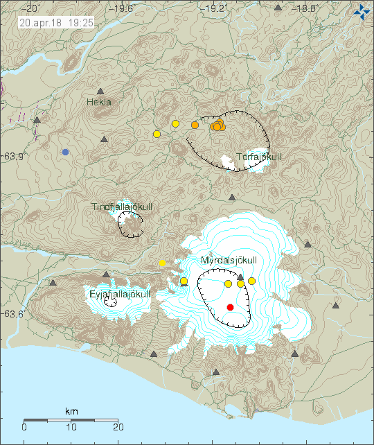
This morning (on 20-April-2018) an earthquake swarm took place in Torfajökull volcano. This was a minor earthquake swarm and largest magnitude was 2,4. All other earthquakes where smaller in magnitude.


The earthquake activity in Torfajökull volcano. Copyright of this image belongs to Icelandic Met Office.

There isn’t a lot happening in Katla volcano on this image. It is all quiet at the moment. In general it is also really quiet in Iceland at this moment.

Donations

Please remember to support my work even if it is quiet at the moment in Iceland. It is impossible to know when that changes. I also have the bill problem for May ongoing and that is explained here. Thanks for the support. 🙂

Hydrothermal activity creates dangerous ice cave in Hofsjökull volcano

Hydrothermal activity has formed a ice cave in Hofsjökull glacier (volcano details here). According to an announcement by Icelandic Met Office this ice cave is dangerous due to sulphur (SO2) pollution and that it goes above 60ppm. That can result in loss of breathing, loss of vision and damage to eyes and lungs. People should only enter this ice cave with gas monitoring hardware on them. One seven year old girl passed out due to sulphur poising some weeks ago in a trip to this newly formed ice cave. There is also a high risk of collapse from the roof of the ice cave as ice appears to be loose above it and can collapse down without warning at any time.

There is also a risk of hydrothermal activity increasing and that is going to result in more sulphur (SO2) gas in the cave and other dangerous gases coming up. This appears to the same location that had increased activity 15 years ago that also formed an ice cave. The reason for this increase in hydrothermal activity is unclear since no earthquake activity has been recorded in Hofsjökull volcano for the past 10 years. This means earthquake activity above background levels, one or three earthquakes are recorded each year in random part of the caldera or parts of Hofsjökull volcano outside of the caldera area. Höfsjökull volcano is on its own rifting zone (information here, related paper here) (marked as SRZ on some documents) along with Kerlingarfjöll volcano (it is now under GVP as Hreppar. I don’t know why that is).

Icelandic News

Veðurstofa varar við íshelli í Hofsjökli (Rúv.is, Picture, Icelandic)

Donations

Please see comment that I am going to leave on this subject.

Dyke intrusion in Öræfajökull volcano confirmed

Recent measurement of Öræfajökull volcano have confirmed a dyke intrusion, the dyke intrusion is located in south part of Öræfajökull volcano and that area is showing inflation. At the moment the amount of magma is now estimated at being close to the total of what erupted in 2010 eruption of Eyjafjallajökull volcano. At the moment the dyke is at depth of 2 – 6 km and that explains current hydrothermal activity in Öræfajökull volcano and why it is increasing. How long this is going to go on is not known at the moment. Öræfajökull volcano is a stratovolcano with everything that comes with it (information about this type of voclano can be found here and here).


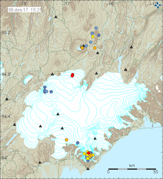
The earthquake activity in Örfæajökull volcano for the last 48 hours. Copyright of this image belongs to Icelandic Met Office.

Last week total of 160 earthquakes where recorded in Öræfajökull volcano and that is a first time record for Öræfajökull volcano having this many earthquakes since recording of earthquakes started in Öræfajökull volcano (~1995?). Earthquake activity seems to be stable at the moment, when that changes is impossible to know at the moment.

Web cameras

There are now two web cameras. The websites are based on non-dynamic folder settings so this links are going to expire rather quickly.

Fagurhólsmýri web camera (only valid for now)
Web camera bridge (only valid for now)

Donations

Please remember to support my work with donations. It helps me greatly. Thanks for the support. 🙂

Cauldron in Öræfajökull volcano continues to get deeper and wider

Latest news of the cauldron that has formed in Öræfajökull volcano is not good. According to the news on mbl.is the cauldron got larger by 20 meters over a 9 day time period. Current shape of the cauldron now is close to the one of water droplet (according to the news). The hydrothermal activity is expanding to the south at the moment.


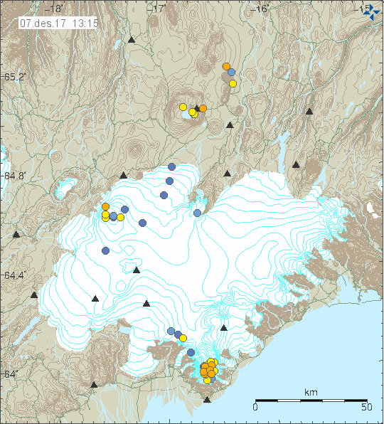
Current earthquake activity in Öræfajökull volcano. Copyright of this image belongs to Icelandic Met Office.

Earthquake activity in Öræfajökull volcano is constant, sometimes bad weather is preventing detection of earthquakes. There has been a small increase in magnitude of earthquakes being detected at the moment that change is not large as most earthquakes are below magnitude 1,0.

Icelandic News (in English)

Öræfajökull caldera has deepened considerably (mbl.is)

Donations

Please remember to support my work with donations. Everything helps me running this website. Thanks for the support. 🙂

Uncertainly level declared for Öræfajökull volcano, aviation code moved to yellow alert

Yesterday the Department of Civil Protection and Emergency Management declared uncertainty level for Öræfajökull volcano. Aviation colour code was also moved up to yellow alert level (can be viewed here).

Current status is that a ice cauldron has formed in the centre of the Öræfajökull volcano caldera. It is about 1 km wide and around 21 to 25 meters deep according to early measurements. This is the first time in documented history that such ice cauldrons has formed in Öræfajökull volcano. It is now believed that the ice cauldron has been emptying it self all week resulting in smell of sulphur in Kvíá glacier river. The glacier river can be viewed here on Google Maps Street View. Currently there is not a lot of earthquake activity happening in Öræfajökull volcano. This is to be expected (I guess). It is also worth noting that Öræfajökull volcano did do in few months what took Eyjafjallajökull volcano 16 years to do until an eruption happened.

There is not a lot of details on earlier eruptions from Öræfajökull volcano. Earliest eruption to our in time took place between 1727 and until 1728 (289 years). Before that an eruption took place in 1362 (655 years) and lasted for five months. Currently I don’t have a lot of information about the current status. This is due to lack of measurements as it was not expected that Öræfajökull volcano would do this even if earthquake activity was happening in the volcano. It was only from October (it seems) that it was figured out that something was going on in Öræfajökull volcano.


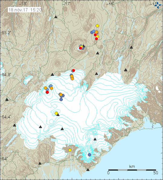
No earthquake activity in Öræfajökull volcano during the past 48 hours (blue dot in the south part of the image). Copyright of this image belongs to Icelandic Met Office.

Images of the new ice cauldron can be found here on Icelandic Met Office website.

I’ll post new information in this article as needed. If anything major happens I’ll write a new article.

Article updated at 16:26 UTC. Added information that I forgot.

Summer earthquake activity in Katla volcano

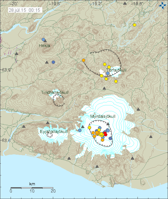
For the past few days there has been summer earthquake activity in Katla volcano. None of the earthquake have reached magnitude 2,0 so far.

150728_0015
Earthquake activity in Katla volcano. Copyright of this image belongs to Iceland Meteorological Office.

This earthquake activity appears to be normal in Katla volcano for the moment. The reason for this activity is melting of the glacier, that means less weight on the volcano, less pressure means changes to the hydrothermal activity inside the caldera of Katla volcano. It can be expected that this earthquake activity is going to continue for a while, at least until October at the longest, or to the time when it starts to snow again in Iceland.

Increased ground heat measured in Surtsey island

It was in the news yesterday (21-July-2015) that scientists have measured higher ground heat in Surtsey Island. The change is 10 degrees (Celsius) from measurements taken some two to three years ago. The theory is that the ground in Surtsey island started to warm up after an earthquake that happened last spring (2015). There have been few earthquakes in Vestmanneyjar volcano system during the past few years, no major swarms have taken place so far.

It is clear by the increased ground heat that magma is on the move in Vestmanneyjar volcano system. It’s too early to know if an eruption is going to take place in next few years. At the moment there is nothing imminent suggesting that is the case, volcanoes often warm up at the surface just too cool down. The largest risk now in Surtsey island are possible steam explosions. They are only risk to local bird and plant life in the summer time.

Icelandic News – in Icelandic

Nýjar tegundir finnast í Surtsey (Rúv.is)

Donations: Please remember to donate to support my work. I do have a summer job at the moment, yet I continue to broke (#$%&%$#) and having problems (#$$%&). Thanks for the support. 🙂

Long term plan: I’m currently building a new long term plan. I am going to write about it on a new site that I am going to set-up once I stop working. That is going to be by the start of November (I hope).

Alert level for Bárðarbunga volcano lowered

Today (1-June-2015) the alert level around Bárðarbunga volcano was lowered to uncertainty level from danger level. This means there are no longer any travel restrictions in the area. Besides normal spring closure in the highlands due to the snow melting (and creating mud areas). There is a risk of snap floods in the area due to hydrothermal activity in Bárðarbunga volcano. It remains high according to the latest news. The risk area for that melt water is in Jökulsá á fjöllum glacier river, since melt water can collect under the glacier and then flood the river days to weeks later. It is also not known what is going to happen when the summer melt period starts in Jökulsá á fjöllum glacier river. A new lake might from in the area next to the glacier where the lava blocked the glacier river path, the glacier water comes from Dyngjökuli glacier.

Icelandic News about this

Frá hættu­stigi á óvissu­stig (mbl.is, Icelandic)
Ekki lengur hættustig vegna Bárðabungu (Rúv.is, Icelandic)
Viðbúnaður vegna jarðhræringa við Bárðarbungu færður niður á óvissustig (Vísir.is, Icelandic)