
Latest news of the cauldron that has formed in Öræfajökull volcano is not good. According to the news on mbl.is the cauldron got larger by 20 meters over a 9 day time period. Current shape of the cauldron now is close to the one of water droplet (according to the news). The hydrothermal activity is expanding to the south at the moment.
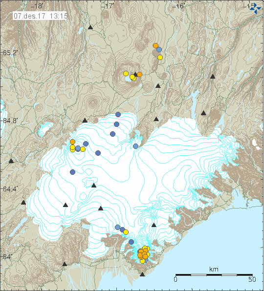
Current earthquake activity in Öræfajökull volcano. Copyright of this image belongs to Icelandic Met Office.
Earthquake activity in Öræfajökull volcano is constant, sometimes bad weather is preventing detection of earthquakes. There has been a small increase in magnitude of earthquakes being detected at the moment that change is not large as most earthquakes are below magnitude 1,0.
Icelandic News (in English)
Öræfajökull caldera has deepened considerably (mbl.is)
Donations
Please remember to support my work with donations. Everything helps me running this website. Thanks for the support. 🙂
Conductivity in Múlakvisl popped back up to over 300 Microsiemens/s over night. It correlates well with increased water level, so it shouldn’t be mud on the sensor.
https://i.imgur.com/iPgNnT0.png
Is there any webcam for Öraefajökull?
Some more webcams, the best should be “Gígjukvísl austur” – in case anything happens.
http://vegasja.vegagerdin.is/eng/
They say that there is Magma on the move from 2-6 Km 2000+ Meters, that is from the top Hvannadalshnjúkur and to sea level……It takes a lot of heat and magma to melt all that old glacier ice in this short time.
http://www.almannavarnir.is/frettir/fundur-visindarads-almannavarna-7-12-2017/
I was hoping for this to be English. That has not been the case, current evolution means there are major problems ahead.
What is to expect in this situation? What could be the development?
In the article, new webcams are mentioned.
This is what I could find.
From Fagurhólsmýri pointing north http://brunnur.vedur.is/myndir/webcam/2017/12/08/webcam_fagurholsmyri.html
River Kvíá (Ringroad 1) http://brunnur.vedur.is/myndir/webcam/2017/12/07/webcam_kvia.html
River Kotá (Ringroad 1) http://brunnur.vedur.is/myndir/webcam/2017/12/08/webcam_kota.html
River Virkisá (Ringroad 1) http://brunnur.vedur.is/myndir/webcam/2017/12/07/webcam_virkisa.html
Change date manually!
Jón, with changes of this nature and at this speed how long would you think before major issue requiring evacuation happens?
Difficult to say at this rate. I don’t observe many volcanoes like this in Iceland so I got limited data to work with. But the situation doesn’t look good.
http://www.almannavarnir.is/france/
google translate recognizes Icelandic and translated this:
Meeting of the Scientific Advisory Council on Civil Protection 7.12.2017
December 7, 2017, 17:31
Today a meeting was held in the Scientific Council on Civil Protection of Öræfajökull. The results of the meeting are as follows:
During the past week, small earthquakes that have occurred in Öræfajökull have increased. Last week there were 160 mini-jokes. So many earthquakes have not been detected there before.
The earthquakes are predominantly dispersed in and around the top 10 km of the Earth’s crust.
The latest measurements of the seabed in the Öræfajökull caldera show that it continues to deepen and expand in accordance with sustained increased geothermal activity and that water drains from the boiler.
Measurements in Skaftafellsá, Virkisá, Kotá and Kvíá show insignificant changes in recent weeks. Measurement of conductivity and chemical composition shows that geothermal water is present in Kvíá.
Further interpretation of the measurements of last year’s crust changes shows small amounts on the southern jetty of the glacier.
Scenarios and measurements in the area indicate a small particle penetration of about 2-6 km depth below the mountain.
Over the last few weeks, monitoring at Öræfajökull has been greatly increased, watermarks, earthquake meters, and GPS GPS devices as well as some webcams have been added. Research on the ground has been increased.
Last updated: December 7, 2017 at 17:31
What’s under the ice of Öræfajökull ?
A paper by the University of Iceland. Worth reading:
http://earthice.hi.is/sites/earthice.hi.is/files/Pdf_skjol/grein_jokull64_eyjolfur_magnusson_et_al_e2015.pdf
(sorry if posted already)
Here is an interesting article about the evolution of stratovolcano eruptions on Earth magazine shared by the University of Iceland Volcanology and Natural Disaster Group. They add that Öræfajökull is possibly on Stage 2 of the erupting phase described in the article.
https://www.earthmagazine.org/node/21527
One comment that was and is total nonsense moved from view.
1. Is anyone aware of an available image of the cauldron–even a graph–of the cauldron in profile. That is, showing the depth of the cauldron relative to the nearby surface of the ice cap and then the depth of the depression and then the distance between the bottom of the depression to the bedrock or soil of the volcano?
This link had some good graphics that would be great to compare side by side with an image like I tried to describe above.
2. I don’t recall seeing an image showing the current or most likely water runoff or flood-water routes as the heat increases. Is there such an image available?
3. Thanks for all you do, Jon. I trust you are keeping yourself safe, fed and healthy!
Flood maps are eg. on p. 34 in: Vulnerability to jökulhlaup hazards: A case
study of the Þjórsá floodplain, Southern Iceland by Jasmine Hayes (she talks also about other regions than the Þjórsá floodplain) https://skemman.is/bitstream/1946/28347/1/Hayes_Thesis_180617.pdf;
or M.T. Gudmundsson, etal., Öraefajökull melting scenarios. (Chapter III) in: E. Pagneux, etal., Volcanogenic floods in Iceland : an assessment of hazards and risks at Öræfajökull and on the Markarfljót outwash plain (2015) (https://rafhladan.is/handle/10802/11705)
Oooops, This link has good graphics that would be good to compare:
http://earthice.hi.is/sites/earthice.hi.is/files/Pdf_skjol/grein_jokull64_eyjolfur_magnusson_et_al_e2015.pdf