
This information is going to go outdated quickly.
This is the current information about the eruption in Bárðarbunga volcano.
Please note: Since I cannot go to the area that is erupting my self (it is closed and I also live in Denmark at the moment). I have to relay on what is being told in the news and released by Icelandic Met Office along with other data. This means that I spend most of the day collecting data and working out what is going on (my view in most cases). This means that in most cases I write post late in the day when daily observation is done.
Current status of the eruption in Bárðarbunga volcano
- New fissure did open around 2 – 3 km south of the eruption fissure that started erupting 31-August-2014.
- Comments on this website did notice the eruption around 04:00 UTC on 05-September-2014. At the same time there was an minor increase in harmonic tremor on SIL stations close to the eruption.
- The new eruption fissure is around 1 – 2 km long. It might get longer as time passes.
- The new eruption was first reported by the press around 06:00 – 08:00 on Rúv.
- New cauldron has formed some 6 km in Dyngjujökull glacier. The glacier in the that area is 300 to 350 meters thick. Last report was that this cauldron was getting deeper during the day.
- Higher conductivity has been reported in Jökulsá á fjöllum glacier river. That is currently continuing on that last check I did on Icelandic Met Office website.
- Smell of rotten eggs is now coming from Jökulsá á fjöllum. Normally there is no such smell of that glacier river.
- Inflation in the dyke continues, not on the same speed as before, but it is ongoing.
- The rift valley appears to continue expand were he is visible.
- The air around the eruption site is toxic due to release of SO2, CO, CO2, fluorine gases and other dangerous gases.
- The water vapour cloud goes up to 4,5 km according to latest measurements.
- The SO2 goes the way of the wind direction at any given time.
- The lava field has just 1 km to Jökulsá á fjöllum glacier river. Once the lava enters the river it might start to build a dam and the lava is going to explode and steam a lot in the process.
- Largest earthquake since midnight was magnitude 5,3 that took place at 01:19 UTC. It took place in Bárðarbunga volcano caldera rim. As other large earthquakes since this events started.
- Largest earthquake in the dyke area took place at 14:31 UTC and had the magnitude of 3,2. It was under the glacier were most earthquake activity is now taking place.
- Volcano eruption with ash cloud is now expected to take place. When and exactly where it is going to take place is not known at current time. I don’t think it going to have effects on international flight. But the local effects might be big if wind is in the direction of populated areas of Iceland.
GPS inflation
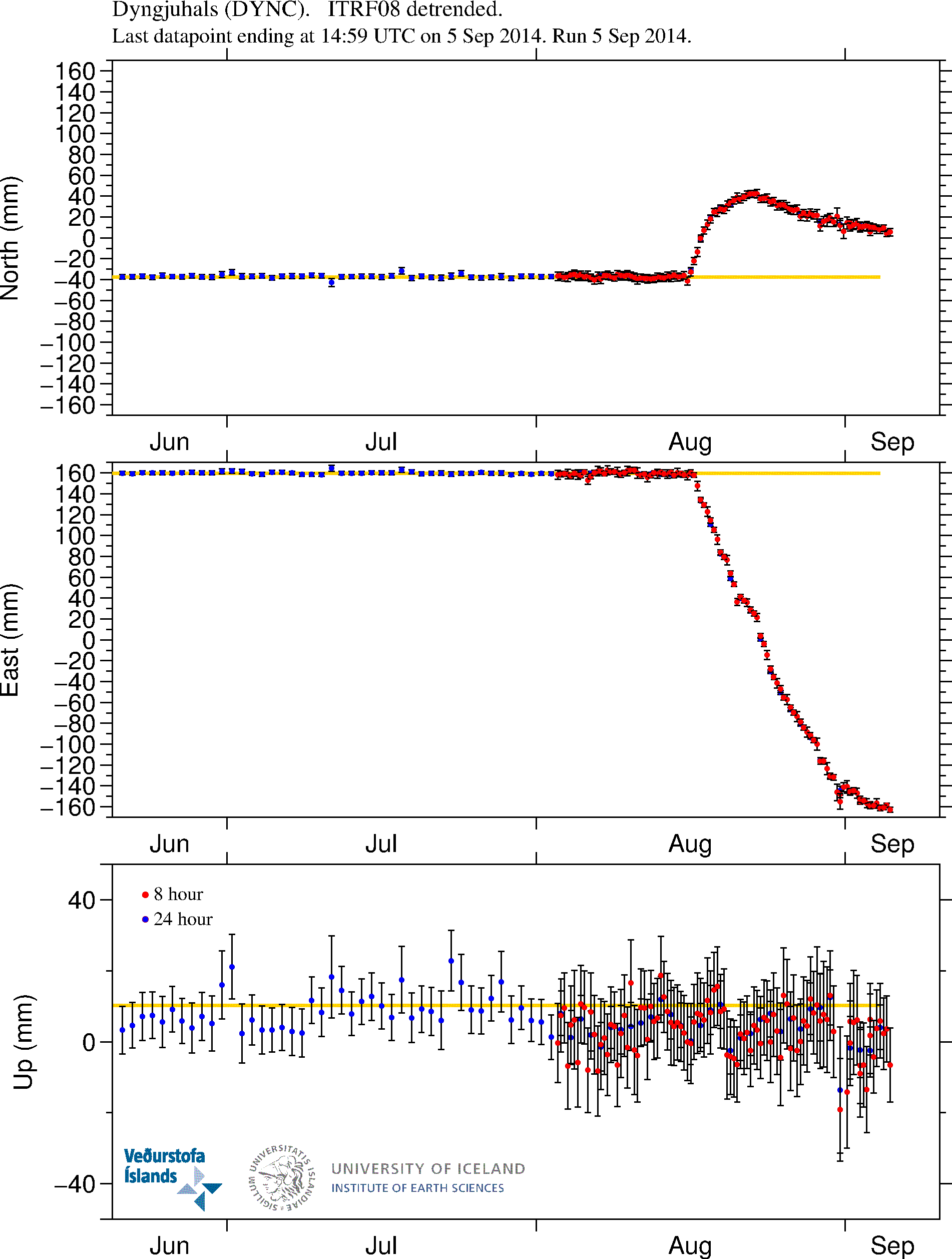
GPS measurements of the inflation that is currently taking place in the dyke. More GPS data can be found here. Copyright of this image belongs to University of Iceland.
Magma continues to flow into the dyke. It is at slower rates than before, but it still flowing into the dyke at rates that current eruption is not powerful enough to equal or drop the pressure inside the dyke. This is going to result in more eruptions as we have already started to see. When and where they are going to take place is something that is not known.
The eruption area is closed to the public
Due to risk of dangerous gases and flood the eruption area is closed to the public. Anyone that is found within the closed zone is going to get heavy fine. Going to this area is also extremely risky sine the area that is now eruption is extremely unstable with the risk of new eruption opening up without warning in the fault area and even outside it (if there is a weakness in the crust the magma is going to go that way). Police in Iceland have already spotted and fined two cars that were trying to enter the closed off area. This area of Iceland is also out in the middle of nowhere. The town is up to 10 hours away in a car (due to bad roads). Weather is also extremely unpredictable and can change without warning. So if you are thinking about going on car or foot. Don’t go!
The good news is that it is still allowed to fly over the area. So get one of those tours. I don’t know what they cost, but I know they take place if weather allows.
News bits
Arrested near the Holuhraun eruption (Rúv.is)
See the lava creeping forward at Holuhraun (Rúv.is, video)
The powers at play beneath the surface (Rúv.is, video)
More news in English can be found here (Rúv.is).
Updates for 06-September-2014
- As noted by many here there is now news report on how much Bárðarbunga volcano has lowered since 16-August-2014. Bárðarbunga volcano has lowered some 15 meters according to latest measurements. This does not reduces the risk of eruption in Bárðarbunga caldera, in fact, this might increase it by a large margin. Such large drop in a mountain has not happened in Iceland since Askja 1875 when that volcano dropped some 300 meters in one of the largest eruption in the 19th century. According to the news on Rúv the caldera crust is in fact floating the magma that is keeping it up. Part of that magma is now erupting just north of Dyngjökull glacier.
- Magnitude 5,0 earthquake took place in Bárðarbunga volcano at 05:40 UTC. It was in the NE Bárðarbunga in the caldera rim.
- The risk of large eruption in Bárðarbunga volcano has increased due the current activity and drop of the caldera (as explained above). When such eruption would take place is impossible to know at this time.
- The lava field is now just 900 meters from Jökulsá á Fjöllum glacier river. It is going to get into contact with the main stream sometimes in the next 24 hour period.
- The activity in the new eruption fissure has decreased a little over the past 24 hours. It is now only erupting in one or two craters at the moment.
- There is high risk of new fissures opening in the rift valley without warning. Both outside the glacier and below it. If an eruption takes place under the glacier there is going to be sudden glacier flood that is going to hit without warning.
- Possible minor eruption might have happened under Dyngjökull glacier in last few days. As there have been cauldron formations in it. One of the cauldron is some 6 km from the glacier edge. The deepest cauldron is 35 meter deep according to radar measurements.
- A new cauldron was also found some 10 km from the edge of Dyngjujökull glacier. This suggest that minor eruption took place there in past few days.
- Blue mist has been seen today in east Iceland. It is not clear what is happening, but there are clues that this blue mist is connected to the eruption. Sensors to measure this blue mist have been sent to east Iceland. This blue mist can also be seen on satellites that Icelandic Met Office uses for weather measurements.
News bits for 06-September-2014
Rannsaka bláa móðu á Austurlandi (Rúv.is, picture of the blue mist, Icelandic)
Eldstöðvarnar í Holuhrauni – Myndband (Rúv.is, Icelandic, video)
Updates for 07-September-2014
- Earthquake with the magnitude of 5,4 took place at 07:07 UTC. This earthquake took place in the caldera rim as other earthquakes in Bárðarbunga volcano.
- The flow of magma is currently 100 to 200 m³ every second.
- The new fissure has stopped erupting according to latest news.
- There is a high risk of new fissure opening up in the erupting area without warning.
- The lava field has reached Jökulsá á Fjöllum glacier river. This is going to increase conductivity in the river as the lava goes more into the glacier river. There is a lot of steam cloud being created following this. It is not clear when the lava field is going to dam the glacier river.
- There are now only 2 – 3 craters erupting in the main erupting fissure. The power of the eruption remains the same.
- Earthquake activity continues south of current eruption. Most of the earthquake activity now is taking place in the glacier, where minor eruptions have been taking place in past few days.
- There is no sign of this activity is about to end.
- Bárðarbunga volcano caldera continues to sink. There is a lack of earthquakes in the caldera it self. That suggest the heat below the crust is high enough to make the crust soft and that prevents earthquakes from happening. More on this tomorrow (Monday).
News bits on 07-September-2014
100 – 200 rúmmetrar úr jörðu á sekúndu (Rúv.is, video, Icelandic)
Svona hefur Bárðarbunga sigið (Rúv.is, picture of the lowering of Bárðarbunga caldera, Icelandic)
Article updated at 14:04 UTC on 06-September-2014.
Article updated at 14:11 UTC on 06-September-2014.
Article updated at 18:16 UTC on 06-September-2014.
Article updated at 18:18 UTC on 06-September-2014.
Article updated at 18:29 UTC on 06-September-2014.
Article updated at 19:43 UTC on 06-September-2014.
Article updated at 14:52 UTC on 07-September-2014.
I mean Mafl, stupid auto spell checker on the phone…
Article has been updated with new information.
The “lake” behind the fissure on the right seems tob in contact with lava. There is much steam in the moment…
Yes I’ve noticed that, I’m also interested in this blue mist in the East of Iceland that Jon has put on the update.
Water from Dyngjökull increasing?
I don’t know. The measuringstations which you can see in the net, are too far away. If they show the waterlevel rising, you see it first on the webcam… 🙂
It could be more meltingwater from the sun today.
Blue mist? This is new
Yes it is new hopefully we may get answers soon, I think Jon said they were analysing it.
This is the new bit Jon has added.Blue mist has been seen today in east Iceland. It is not clear what is happening, but there are clues that this blue mist is connected to the eruption. Sensors to measure this blue mist have been sent to east Iceland. This blue mist can also be seen on satellites that Icelandic Met Office uses for weather measurements.
Just googled “blue mist and volcanism” and surprisingly blue water and mist is rather common. Not making any comparison what so ever to Laki but one of the sites brought up by the search was the Laki wiki site. It is mentioned that the lLaki eruption “turned all the water tempid and blue”
Those so called secret meetings and not liking what other people are saying should get a life. This is modern times social media is alive and kicking, it’s never going to go away so they will have to live with it. Its thanks to people like Jon and Volcano Cafe that fill in the blanks that scientist won’t say. So I take my hat to the people that take time to gives us facts.
So what do the magmachamber of a volcano look like mattmabus. Are there any difference between a strato- and a shieldvolcano?
It’s a good question. As you probably know low viscosity shield volcano lava comes fairly directly from the mantle, whereas stratovolcano lava includes a lot of remelted rock and often has had time to separate into chemically different layers, and sometimes has continental plate between it and the mantle.
However, even shield volcanoes have magma chambers, at least according to this old webpage http://hilo.hawaii.edu/~kenhon/GEOL205/Ascent/default.htm I couldn’t google up any page making direct comparisons although no doubt there must be many.
Bárðarbunga however is something of a hybrid, as it’s the result of a battle between Iceland’s mantle plume hotspot and the splitting of the Mid Atlantic Ridge. It pushes through relatively freshly formed (but still already old and evolved) continental plate where the ridge is trying to open in a new place due to the presence of the hotspot. So unlike Hawaiian pure hotspot volcanoes its eruptions can start more like a stratovolcano but then settle into the hot spreading shield volcano type that accounts for its wide flat shape. Or so I’ve read, and partially understood.
All magma chambers are different.
Yes, but can one explain the general geography of one?
You can calculate the volume of a cylinder here
https://www.google.co.uk/?gfe_rd=cr&ei=N04LVOHMJe6q8wfP7YBo&gws_rd=ssl#q=calculate+volume+of+cylinder
If Bárðarbunga volcanic plug is say 10km across and lets say a very minimum of 10km deep, that is 785.4 km3. If that plug collapses, I think we would have been better just having a Laki style eruption.
Am I correct in the assumption that what drops into a chamber during a cone collapse, comes back out again? Krakatoa certainly did, but lots of water was involved, but we do have that situation here in ice. So could this not turn into a VEI 7-8 eruption !! based on the volumes of rock stated here.
http://en.wikipedia.org/wiki/Volcanic_Explosivity_Index
ie VEI7 such as Mazama (c. 5600 BC), Thera (c. 1620 BC), Samalas (Mount Rinjani) (1257), Tambora (1815)
or worse VEI8 such as Yellowstone (640,000 BC), Toba (74,000 BC), Taupo (24,500 BC)
One thing, if we get an eruption bigger than Krakatoa I will hear it here in Scotland, so maybe time to head south! “The final explosive eruption was heard 4,830 km (3,000 miles) away” and it was only a VEI6
http://en.wikipedia.org/wiki/1883_eruption_of_Krakatoa
Obviously I hope this never happens for us or future generations, but I think the people with knowledge and power should consider all options, it’s very easy to say it won’t happen. But has anyone recorded a 10km wide crater base dropping 15metres !!! am I reading that correct, or has the ice just melted at the base and the ice surface dropped 15 metres?
If you plot all the seismic points on this 3d page, you can see the quakes around the caldera are vertical from chamber to surface. In fact if you flip the plot upside down so you are looking up the core you can see no points in the middle. For me this suggests the quakes are taking place at the contact between the volcanic plug wall and the country rock. So maybe the plug has dropped. maybe it is just held in place by the pressures in the chamber and is moving like a piston, currently dropping, but that could change if pressure increases, or maybe it will just go one way and that’s down. Whatever I can only see one outcome and thats a very large eruption from Bárðarbunga.
I am not a qualified scientist (I dont have a degree) and these are just my ideas, they could be total rubbish, but this is how I read the current situation. For those who have different ideas please do explain them with science, rather than just ‘it won’t happen’ without explaining why it won’t. The hope that something won’t happen is not always a good policy unless you have some evidence.
I will ceratinly be keeping a very close eye on things.
Fantastic red sunset here in Scotland tonight.
GLA
3D plot in above post was from here
http://hraun.vedur.is/ja/quakes3d/
is it possible a powerfull explosion to occur and triger a jokulhaup to the nearby river so as to reach the fissure ?with tremendous results?
It all depends on the details. Some water/lava interactions are explosive, some are not. But yeah, that’s one reason so many of us remain glued to the cams.
Can the lahar cover tha fissure >?Could be hardly a possibility?
How to interpret that rumbling between 14h and 16 local time?
http://hraun.vedur.is/ja/drumplot/vatnajokull.html
In Iceland it could always be sheep, especially if it happens on only one monitor. Or cars or wind. At least that’s true for Jon’s webicorders — not sure for the official ones. Definitely some long period quakes on there though!
a lahar from bandabunga could cover the fissure?
Johan all magma chamber are different they. All have different shaped chambers. As for Volcanos, here is something for you.Strato volcanoes and shield volcanoes are different because of their shape and also because of the may they erupt.
Strato volcanoes have steep slopes, shaped like a tall narrow cone.. when a strato volcano erupts vast amounts of gasses such as sulphur dioxide, water and dust are thrown up into the atmosphere. This can cause global warming and pretty sunsets, magma obviously comes out too ( the magma in strato volcanoes is very thick ) . These eruptions are very violent, they can blow up to half of the volcano away leaving a massive crater in the middle of it.
Shield volcanoes have gentle slopes, shaped like a low wide cone ( or a shield -hence the name ) when a strato volcano erupts lava fountains can form as hot liquid lava is thrown into the air but these are not usually very high. The lava that comes from shield volcanoes is very runny ( unlike strato volcanoes ) so red hot rivers of lava run down the sides of the volcano.
I’m sorry it’s a bit long winded, but it’s what I remember learning at school and geology.
Goodnight.
Could someone explain to me why, for instance, the earthquake occured at ~18h44 UTC (in the low right corner http://hraun.vedur.is/ja/drumplot/IDYN.png) isn’t reported on 3dBulge ? It’s not the only one …
Thanks a lot
Just a guess but 3dbulge only shows quakes within a small rectangle (see the map), whereas the webicorders can pick up quakes at any distance (including really big ones on other continents, although these would show as long wavy lines). So most likely they’re just outside the area of the visualization.
Also, 3dbulge gives the option of toggling verified/unverified quakes. You may be seeing an unverified quake.
Or of course it’s not working right. Always a distinct possibility!
Blue mist is mentioned in this article about the 2000 Hekla eruption: http://earthice.hi.is/hekla_eruption_2000
‘The blue mist is caused by continuos degassing of the magma as it flows along the lava stream. Such blue mist was also observed farther east along the flank of the volcano. This is indicating that lava is still flowing from the crater close to the summit area.’
You are right Wial, and also the Hawiian volcano sits on a hot spot, but as the island moves the volcano dies and a new island is formed. Iceland is unique because it sits on top of two plates and a hot spot. That’s why Icleland is always under stress.
Thor, I picture you standing on top of a volcano with a Viking hat, and a hammer in one hand and a lighting bolt in the other and thunder booming all around you, don’t ruin my image by saying I’m wrong.
I added a new link to a news video showing the eruption as it is today.
Thanks Eddy. The differerences between the two types that you describe is the same facts as from my education. But it was sad that the volcano chamber of a volcano, probably a strato volcano isn’t a chamber or a room with connection down to the mantel. So what does ut look like in general? Bartharbunga being a mix of a hotspot and a stratovolcano has demonstrably formed a caldera. The volcano has plummit into something?
There is a new video from today. Not so spectacular, but it icludes a view from Askja and at the very end you can see for a short time the lava near the river and the “lavanado” :):
http://www.ruv.is/frett/eldstodvarnar-i-holuhrauni-myndband
Yes there is a small chance that the magma in the dyke is still making it’s way into the Askja system.
No. That has stopped completely. The reason is the eruption, there was also something in the crust that prevented the dyke from moving into Askja volcano. any effect that the dyke has on Askja volcano now are only tectonic effects due the stress the dyke is creating on the crust in this part of Iceland.
Does anyone have an idea how far the rift goes under the ice cap.
Is that a vehicle near the foreground of the camera on Bárðarbunga-2?
For anyone’s interest their has been a lot of over 5 mag earthquakes around the Easter Island area, better start keeping an eye on Rano Kau volcano.
Latest on The Easter Island Area their has been 5.8, 5.1, 5.4, 6.1 and 5.2 magnitude earthquakes around the Easter Island area.
Thats ineteresting. Rano Kau was assumed to be extinct, but then so was Chaiten….
Blue mist? Methane is a blue volcanic gas isn’t it? The distinct smell might be confused with SO2.
Methane itself is actually oderless. The “natural gas” one uses for a stove has been modified by adding sulfur so that leaks can be easily detected.
No I’m sure it is just. Dormant.
My mistake it is extinct though Easter Island sits on a hot spot and can come to life.
The eruption really has increased in strength today and right now looks incredible on the webcams
With a great lavastream…wow
Captcha says: How sugeedoo! (Whatever this means… 🙂
I think it because it’s dark now. It always looks better at night
But this lavaflow i haven’t seen yet…
Popcorn time 😀
Edited: Fixed the incorrect tags used. – Jón Frímann.
http://i58.tinypic.com/25hcr6e.jpg
*Gives up after 3rd attempt..No images allowed Jon ?
You have to use for pictures in WordPress and it has to be in html format. The code looks like this (without < > tags).
img src=”http://” alt=”” /
That is a beautiful pic 🙂
I am going to try jon’s code – wish me luck
Edit: You forgot the < > at the start and the end. Fixed. – Jón Frímann.
4.2 at 18:43 bardarbunga
It seems on Mila cams we have a much broader “lava-river” floating to lower grounds from the eruption tonight, compared to yesterday…. Does this mean more lava is erupting now than yesterday?
I was watching cam 2 and saw a sudden burst. Anyone else see it?
I can only imagine how awesome it would be to actually see this in person
If people want to add images to the comment. Please follow this guide on how to do so properly.
http://www.w3schools.com/tags/tag_img.asp
But please keep images limited or just links to them. Since many images in the comment section increase the load time of this website.
Testing pic
Sept 6 almost 5 pm edt – it just flashed brighter again.
http://tinypic.com?ref=jg5xf5
this has no edit to fix or delete my posts 🙁
Edit: I did try to fix the image. But the image did not work at the host end. – Jón Frímann.
Please see this comment for details on how to make images work properly.
http://icelandgeology.net/?p=4916&cpage=3#comment-57285
Thank you jon – this is the direct image
http://i62.tinypic.com/jg5xf5.jpg
Actually this is http://oi62.tinypic.com/jg5xf5.jpg
So you’d write (and here’s hoping this works)
Oh well 🙂
Edit: Standard text to fill into empty comment. – Jón Frímann.
All I see is empty comment.
Please house clean it..was another test HTML attempt with more recent image.Also have now seen your request so wont upload any more images unless its golden.
I did remove the other empty comment. But I just added a text to the parent of this sub comments. If I remove it, the comment chain gets messed up, so I rather don’t want to remove it because of that.
That is a mighty fine river of lava,it really rocks at night
Lava stream does look more prominent now than other nights. Not cooling as quickly away from fountains. Increased flow probably. Should hit river soon, being less than a click away.
Viewing the glacier today, that dark strip in the center of cam 1, I assume, was the rift they have been talking about. It was clear enough today to see it better. MODIS image I seen has it clearly shown. Right in line with the active fissures.
Someone has reported over at VC a question as to what that flickering light is on Cam2 to the very right of the screen on the fissure horizon. Been seeing it myself for about 10 minutes or so now and thinking just the same. Any ideas ?
n/m seeing an image from last night it almost certainly part of a lava flow 🙂
Seismic activity seems to have slowed down.