
This information is going to go outdated quickly.
This is the current information about the eruption in Bárðarbunga volcano.
Please note: Since I cannot go to the area that is erupting my self (it is closed and I also live in Denmark at the moment). I have to relay on what is being told in the news and released by Icelandic Met Office along with other data. This means that I spend most of the day collecting data and working out what is going on (my view in most cases). This means that in most cases I write post late in the day when daily observation is done.
Current status of the eruption in Bárðarbunga volcano
- New fissure did open around 2 – 3 km south of the eruption fissure that started erupting 31-August-2014.
- Comments on this website did notice the eruption around 04:00 UTC on 05-September-2014. At the same time there was an minor increase in harmonic tremor on SIL stations close to the eruption.
- The new eruption fissure is around 1 – 2 km long. It might get longer as time passes.
- The new eruption was first reported by the press around 06:00 – 08:00 on Rúv.
- New cauldron has formed some 6 km in Dyngjujökull glacier. The glacier in the that area is 300 to 350 meters thick. Last report was that this cauldron was getting deeper during the day.
- Higher conductivity has been reported in Jökulsá á fjöllum glacier river. That is currently continuing on that last check I did on Icelandic Met Office website.
- Smell of rotten eggs is now coming from Jökulsá á fjöllum. Normally there is no such smell of that glacier river.
- Inflation in the dyke continues, not on the same speed as before, but it is ongoing.
- The rift valley appears to continue expand were he is visible.
- The air around the eruption site is toxic due to release of SO2, CO, CO2, fluorine gases and other dangerous gases.
- The water vapour cloud goes up to 4,5 km according to latest measurements.
- The SO2 goes the way of the wind direction at any given time.
- The lava field has just 1 km to Jökulsá á fjöllum glacier river. Once the lava enters the river it might start to build a dam and the lava is going to explode and steam a lot in the process.
- Largest earthquake since midnight was magnitude 5,3 that took place at 01:19 UTC. It took place in Bárðarbunga volcano caldera rim. As other large earthquakes since this events started.
- Largest earthquake in the dyke area took place at 14:31 UTC and had the magnitude of 3,2. It was under the glacier were most earthquake activity is now taking place.
- Volcano eruption with ash cloud is now expected to take place. When and exactly where it is going to take place is not known at current time. I don’t think it going to have effects on international flight. But the local effects might be big if wind is in the direction of populated areas of Iceland.
GPS inflation
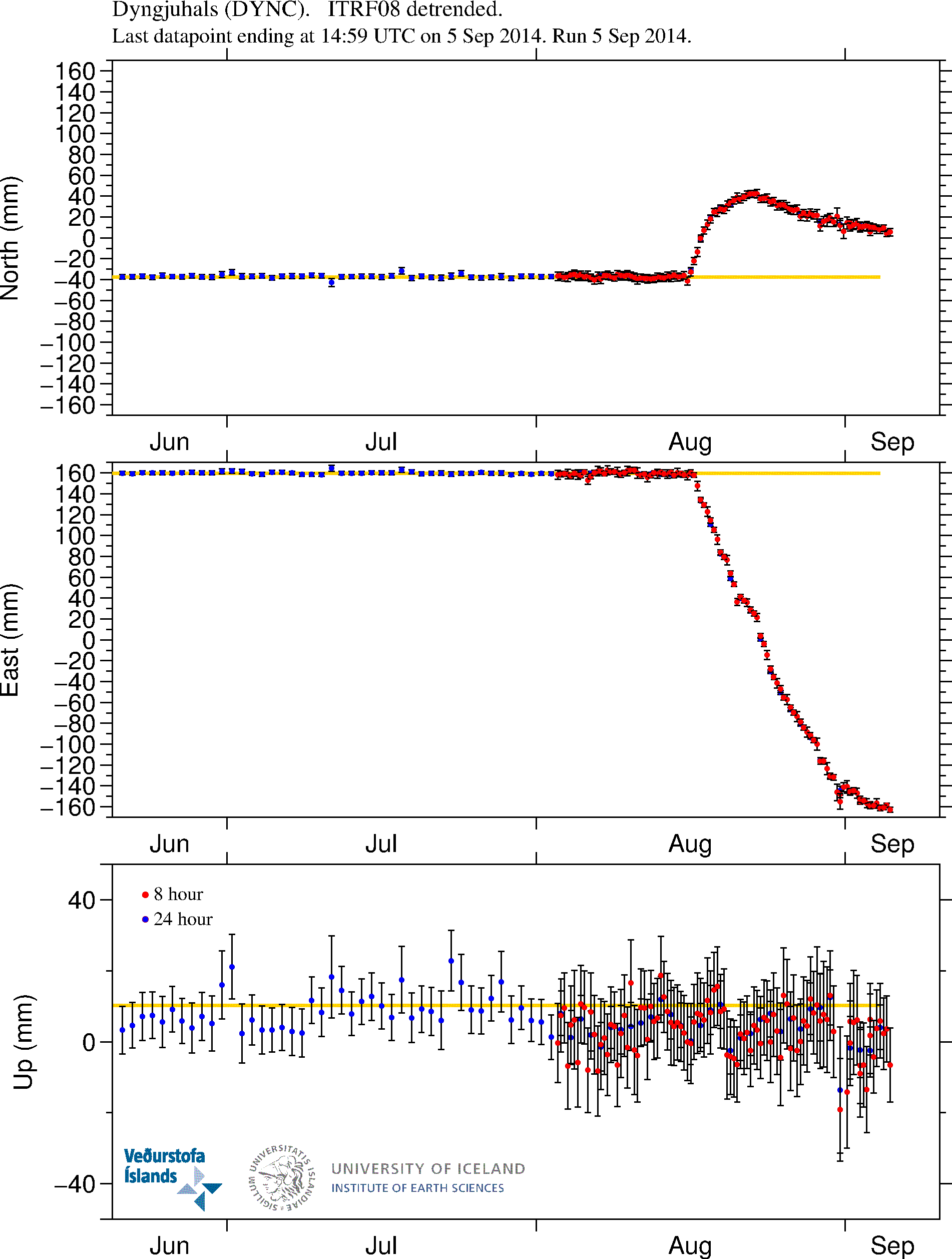
GPS measurements of the inflation that is currently taking place in the dyke. More GPS data can be found here. Copyright of this image belongs to University of Iceland.
Magma continues to flow into the dyke. It is at slower rates than before, but it still flowing into the dyke at rates that current eruption is not powerful enough to equal or drop the pressure inside the dyke. This is going to result in more eruptions as we have already started to see. When and where they are going to take place is something that is not known.
The eruption area is closed to the public
Due to risk of dangerous gases and flood the eruption area is closed to the public. Anyone that is found within the closed zone is going to get heavy fine. Going to this area is also extremely risky sine the area that is now eruption is extremely unstable with the risk of new eruption opening up without warning in the fault area and even outside it (if there is a weakness in the crust the magma is going to go that way). Police in Iceland have already spotted and fined two cars that were trying to enter the closed off area. This area of Iceland is also out in the middle of nowhere. The town is up to 10 hours away in a car (due to bad roads). Weather is also extremely unpredictable and can change without warning. So if you are thinking about going on car or foot. Don’t go!
The good news is that it is still allowed to fly over the area. So get one of those tours. I don’t know what they cost, but I know they take place if weather allows.
News bits
Arrested near the Holuhraun eruption (Rúv.is)
See the lava creeping forward at Holuhraun (Rúv.is, video)
The powers at play beneath the surface (Rúv.is, video)
More news in English can be found here (Rúv.is).
Updates for 06-September-2014
- As noted by many here there is now news report on how much Bárðarbunga volcano has lowered since 16-August-2014. Bárðarbunga volcano has lowered some 15 meters according to latest measurements. This does not reduces the risk of eruption in Bárðarbunga caldera, in fact, this might increase it by a large margin. Such large drop in a mountain has not happened in Iceland since Askja 1875 when that volcano dropped some 300 meters in one of the largest eruption in the 19th century. According to the news on Rúv the caldera crust is in fact floating the magma that is keeping it up. Part of that magma is now erupting just north of Dyngjökull glacier.
- Magnitude 5,0 earthquake took place in Bárðarbunga volcano at 05:40 UTC. It was in the NE Bárðarbunga in the caldera rim.
- The risk of large eruption in Bárðarbunga volcano has increased due the current activity and drop of the caldera (as explained above). When such eruption would take place is impossible to know at this time.
- The lava field is now just 900 meters from Jökulsá á Fjöllum glacier river. It is going to get into contact with the main stream sometimes in the next 24 hour period.
- The activity in the new eruption fissure has decreased a little over the past 24 hours. It is now only erupting in one or two craters at the moment.
- There is high risk of new fissures opening in the rift valley without warning. Both outside the glacier and below it. If an eruption takes place under the glacier there is going to be sudden glacier flood that is going to hit without warning.
- Possible minor eruption might have happened under Dyngjökull glacier in last few days. As there have been cauldron formations in it. One of the cauldron is some 6 km from the glacier edge. The deepest cauldron is 35 meter deep according to radar measurements.
- A new cauldron was also found some 10 km from the edge of Dyngjujökull glacier. This suggest that minor eruption took place there in past few days.
- Blue mist has been seen today in east Iceland. It is not clear what is happening, but there are clues that this blue mist is connected to the eruption. Sensors to measure this blue mist have been sent to east Iceland. This blue mist can also be seen on satellites that Icelandic Met Office uses for weather measurements.
News bits for 06-September-2014
Rannsaka bláa móðu á Austurlandi (Rúv.is, picture of the blue mist, Icelandic)
Eldstöðvarnar í Holuhrauni – Myndband (Rúv.is, Icelandic, video)
Updates for 07-September-2014
- Earthquake with the magnitude of 5,4 took place at 07:07 UTC. This earthquake took place in the caldera rim as other earthquakes in Bárðarbunga volcano.
- The flow of magma is currently 100 to 200 m³ every second.
- The new fissure has stopped erupting according to latest news.
- There is a high risk of new fissure opening up in the erupting area without warning.
- The lava field has reached Jökulsá á Fjöllum glacier river. This is going to increase conductivity in the river as the lava goes more into the glacier river. There is a lot of steam cloud being created following this. It is not clear when the lava field is going to dam the glacier river.
- There are now only 2 – 3 craters erupting in the main erupting fissure. The power of the eruption remains the same.
- Earthquake activity continues south of current eruption. Most of the earthquake activity now is taking place in the glacier, where minor eruptions have been taking place in past few days.
- There is no sign of this activity is about to end.
- Bárðarbunga volcano caldera continues to sink. There is a lack of earthquakes in the caldera it self. That suggest the heat below the crust is high enough to make the crust soft and that prevents earthquakes from happening. More on this tomorrow (Monday).
News bits on 07-September-2014
100 – 200 rúmmetrar úr jörðu á sekúndu (Rúv.is, video, Icelandic)
Svona hefur Bárðarbunga sigið (Rúv.is, picture of the lowering of Bárðarbunga caldera, Icelandic)
Article updated at 14:04 UTC on 06-September-2014.
Article updated at 14:11 UTC on 06-September-2014.
Article updated at 18:16 UTC on 06-September-2014.
Article updated at 18:18 UTC on 06-September-2014.
Article updated at 18:29 UTC on 06-September-2014.
Article updated at 19:43 UTC on 06-September-2014.
Article updated at 14:52 UTC on 07-September-2014.
Has the new Southern fissure closed Again or at least become much less active? I dont see smoke from there anymore on the webcam 2 ?
it seems the erruption calmed down quite signifficantly. So if even this small pressure vent will close, it will increase the chances of an eruption elsewhere. Lets see if we will see an increase in seismicity and tremors
They are reporting more power in the eruption. With lava fountains being up to half higher today than yesterday.
BBC Magazine article.
http://www.bbc.com/news/magazine-29065116
Whistler, how can you see or how do you know the eruption calmed down ?
Daylight will give him that impression. IMO says it has not chaged since yesterday.
34 minutes between earthquakes – is this the biggest gap for a long time? does it mean anything?
http://en.vedur.is/earthquakes-and-volcanism/earthquakes/#view=table
I know this is not related directly to the current Bárðarbunga event, but nevertheless absolutely breathtaking footage of the eruption of Mt. Tavurvur in PNG a couple of weeks ago, with the blast wave first visible in the clouds and a massive sonic boom ten seconds later! Truly amazing to watch Mother Nature in action! Njoi:
https://www.youtube.com/watch?v=Hx5UecbuYw8#t=51
Helmpflicht, That is an amazing video. Thanks for sharing.
Thanks for posting, that really is an amazing video, a must see!
Great information!
Do you have an idea what happens to the current fissure eruption if it would be struck by a glacial flood?
There would be a lot of steam and some explosions when the magma came into contact with water.
yup,the lava will cool down rapidly,and scatter,gass emission and some ash and explotions, but im there is large amounts of water it might start to cool down the lava so much it will start to crust,and might eventually stag the eruption at that area.Now water and lava dont mix very well and water usually dont stop an eruption ,it will continue a while underrwater. creating pillow formation of the rock. depends a little on the volume of water ofcourse.is it still abowe water level it will just change character and be more volatile and explosive,.
Yes there is more power in the eruptions, as for the seismic activity, it is properly just a pause,nothing has changed much since yesterday apart from more toxic gases. My only concern is the. Couldron that was reported yesterday, it was getting bigger and deeper, and also the rift.
According to me, it’s a wrong interpretation to assess the eruption’s activity level on the basis of the plume appearance … It’s just the effect of the light. If you think like that, tonight, you’ll think that the eruption will be going up again 😉
No nothing has changed much since yesterday, I still think there is more magma going into the dyke than what is erupting out so everything is very fluid, things could change without notice. It is still orange for Barda and Yellow for Askja.
Thanks Eddy. I have very limited knowledge but a massive interest in what is happening!
Same here Anne, I’ve always had a fascination with volcanoes and the power of them since I was a kid, there one of the most amazing things on this planet.
15m drop in the level of the Caldera sounds ominous, but I don’t really understand why.
Does it mean something big is going to happen, or that something big has happened, or am I am getting myself excited about a number that means nothing?
It”s due to magma flowing out of the magma chamber under Bardarbunga into the dyke, and the caldera lowering as a result. Those large earthquakes that keep showing up in the area show the ring faulting.
The concern (and increased risk in light of this news) is the lid cracking in this process and allowing ice to contact the magma chamber, causing a phreatic explosion.
Not sure maybe Jon or someone might have an answer, it does sound ominous.
I think first the caldera raised and when the dyke were formed it began sinking.
Iceland’s verdur.is site update mentions the Sept 6th scientist report is going to be reported ‘soon’. I think what that means is the scientists are arguing over what to say in the report…..Jon does such a good job here, and no conflicting reports!
It is already out in Icelandic at Almannvarnir. Orange and yelow like yesterday. Description i wat for english. (goole translate does not do a good work with icelandic),
Yes Jon does do a brilliant job,he fill in all the blanks that the scientists leave out, as for the scientists arguing over what to put down it could be true but I don’t think so.
Volcanoes and earthquakes are my passion too. Have a look at this if you have not seen it already, it’s awesome!
http://www.breakingnews.ie/discover/video-what-it-looks-like-inside-an-active-volcano-641205.html
A little risky?
Report is out on the MET site …
“In the surveillance flight yesterday the ice-surface at Bárðarbunga was measured with the radar system of Isavia’s aircraft. The measurements show large changes on the ice-surface. Up to 15 m subsidence has occurred in the centre of the caldera, which corresponds to a volume change of 0.25 km3. The shape of the subsidence area is in accordance with the elevation of the caldera floor having lowered by that amount.
Subsidence of this order has not been observed in Iceland since measurements of crustal movements started around the middle of last century.”
I don’t believe there is in any disparity in what is being reported.
Only there are multiple scenarios going forward and no one with any high degree of certainty can say which scenario is going to be played out.
Conspiracy theorists on the web say end of days where as rational scientific heads hedge their bets by listing 4 principal scenarios (and then not excluding the possibility of more others) but a fizzle event is just one potential outcome!
I would like to predict a colorful scenario (no not a doomsday event or even a potential scenario acknowledged by IMO etc) but the equivalent to a “Perfect storm” event in volcano terms. It depends a lot on “if something occurs it might have the following consequence” but it unfolds as a chain of geo dominoes toppling.
If the fissure underneath Dyngjujökull glacier erupts enough to create a massive amount of melt water then the resulting flood could potentially reach the active fissures at Holuhraun. This event could potentially trigger massive instability along the dyke (including more sub glacial eruptions and significant unzipping along the dyke). At this point EQ’s generated by such an event could well be the final straw for the big Bardarbunga to enter this volcanic affray.
If the Big B blows big then there is a further potential for Grímsvötn to join the party(albeit a lesser extent).
Then finally with with all those EQ’s and instability that this potential combined event would almost certainly produce then how safe will Askja be hiding behind her granite… Maybe a late gatecrasher to this bitchin’ geo party!
End of days event ?…hell no!
Historical geological event most definitely but then again a fizzle event is more probable (less dominoes to have to line up and fall for that one!) or the many other possible scenarios inbetween.
Now wonders what odds the bookies would offer on a multiple volcanic system event 😛
Its not doomy its just interesting, and we have to wait and see. For those who poo poo such scenarios please research the new info about what laki did to europe and the uk
And a Laki event with todays agrcultural methods, food distrubution and modern medical care would kill just a tiny bit of what the 1783 event did.
i am not sure we can assume being better off. In some ways we are still vulnerable, or even more vulnerable. One difference is, there are a lot more people living in the area now. Another thing is, we rely on a lot of technology (air traffic, combustion engines, fine electronics, mass agriculture) that can be severely damaged by dust and sulfuric acid. A fail of many elements in our supply-chain could have great economic consequences, apart from the health issues and the cost of dealing with it.
It can be an economical disaster, depending on the scale and weather circumstances.
I think I’ve said this before but India may be at greater risk now than it was back then, when 6 million people died. One would have to ask risk assessment experts in India, but you can’t just helicopter in food for tens of millions of people caught in a historic famine. Europe might be OK, except for the collapse of a few agricultural industries, and the gas mask industry would go gangbusters, but it’s other places, massively overpopulated and running out of green revolution resources even without a volcano, that I worry about.
I have added a update for today in this article. If there is a reason to do so. I am going to add a second update later today if anything major happens (in this type of situation, it often does so).
Thanks Jon, your explanations are always so clear and easy to understand.
I wonder whether someone has been out to the Mila webcam site. The little piece of debris that was on the lens has gone, and also all the electrical noise from the last 24 hours. I assume that was from a loose connector somewhere, after all the shaking sustained during that storm.
You people probly all find this a stupid question – but I DONT KNOW! I finally decided to ASK. LOL.
WHAT IS A DYKE?
A dyke or dam or levee to be holds back water.
Its a barrier.
You guys say – flowing into the dyke. I am old. Knowing what a dyke is is on my bucket list!
In volcanic terms, a dyke is an area of magma flowing underground, usually through existing fissures or between layers of lava from previous lava flows. Not at all related to the ‘dikes’ of Holland and other dams.
Think of it as a lateral tube of magma that is an extension from the central magma chamber.
You have 2 different kinds in volcanoes that are almost the same thing; sills and dykes – Sills are vertical, dykes run horizontal 🙂
Thanks for asking. I needed a little clarification on what a dyke in a volcano was too. 🙂
Updated information
6th September 2014 12:00 – from the Scientific Advisory Board
Scientists from the Icelandic Met Office and the Institute of EARTH SCIENCES and representatives of the Civil Protection in Iceland attend the meetings of the Scientific Advisory Board of the Icelandic Civil Protection.
Conclusions of the Scientific Advisory Board of the Icelandic Civil Protection:
In the surveillance flight yesterday the ice-surface at Bárðarbunga was measured with the radar system of Isavia’s aircraft. The measurements show large changes on the ice-surface. Up to 15 m subsidence has occurred in the centre of the caldera, which corresponds to a volume change of 0.25 km3. The shape of the subsidence area is in accordance with the elevation of the caldera floor having lowered by that amount.
Subsidence of this order has not been observed in Iceland since measurements of crustal movements started around the middle of last century.
No signs of eruption or increased geothermal activity in the Bárðarbunga caldera are observed.
The volume of the subsidence in Bárðarbunga is considerable portion of the total volume of the magma dyke.
The most probable explanation is that this subsidence is related to the recent high seismic activity and subsurface magma flow to the northeast.
In the surveillance flight yesterday a shallow, wide depression was observed on the surface of Dyngujökull, 10 km from the glacier edge. Another depression 6 km from the Dyngjujökull ice edge, which has been monitored over the last few days has deepened and is now 35 m deep.
It is likely that these depressions are sings of small and short sub glacial eruptions.
The eruptive activity at Holuhraun is the same as yesterday.
Two eruptive fissures are active. The main activity is on the same fissure that has been active since the eruption began. In addition the fissure that opened yesterday morning is still active.
The lava now extends 10 km ENE and has just under one km to reach Jökulsá á Fjöllum river.
Seismic activity has decreased since yesterday. Approximately 90 earthquakes have been detected since midnight. One earthquake, of magnitude 5 was located in the Bárðarbunga caldera at 05:40 UTC. 14 earthquakes of magnitudes greater than 5 have been located since 16 of August.
Deformation changes since yesterday, measured with GPS north of Vatnajökull are small.
Four scenarios are still likely:
The migration of magma could stop, resulting in a gradual reduction in seismic activity and no further eruptions.
The dyke could reach the Earth’s surface at different locations outside the glacier. Lava flow and/or explosive activity cannot be excluded.
The intrusion again reaches the surface under the glacier and possibly leads to a significant eruption. This would most likely produce a flood in Jökulsá á Fjöllum and perhaps explosive, ash-producing activity.
An eruption in Bárðarbunga. The eruption could cause an outburst flood and possibly an explosive, ash-producing activity. In the event of a subglacial eruption, it is most likely that flooding would affect Jökulsá á Fjöllum. However it is not possible to exclude the following flood paths: Skjálfandafljót, Kaldakvísl, Skaftá and Grímsvötn.
Other scenarios cannot be excluded.
Woah !
Jon, let me get my head around this. Big B has sunk 15 mtrs!! and the ice gap is just wedged in the caldera and sitting there within the rim of the volcano? So is it right the ice is resting above and the magma is coming up through from the mantle right underneath and heading off NE in the dyke?
The IMO have been very cool about this whole event but reading today’s article , it seems a bit more gloomy?
PS good work Jon
So i’m wondering, if the “lid” of the caldera has started to fall in, could heat be escaping from the magma and melting the glacier from within (hence the cauldrons)? What if this situation continues until water comes into contact with the magma chamber? – That’s not a good scenario is it? 😮
I think their will be a higher chance. Of big B erupting, but it will also depend if she drops even more, also if she does go, what effect will she have on Askja.
When it comes to Askja, she is conected to another branch of the same volcanic feature from the same hotspot, She has her own magmachamber, and has shown unrest for some time.
Now, there is a tiny chance she might be sirred up by all the comotion around her. But If Bårdarbunga erupts by it self, I dont think she will be more affected by that, than she is by the fissure eruption.
If the fissure eruption continues northward toward Askja and intrudes and breaks through the Granite rock, she might go of due to that. But My guess is that if she goes of is because the magmachamber underneath her has been stirred up and stressed up so much that it begins to fill and erupts by that. there is no indication at this moment that she is ready for any eruption.But that can change rapidly if things fall in to the right places. At this time Im more worried about Bårdarbunga it self, and if that caldera colapses and what that will turn into. It might become big, Some scientists say that if it colapses, (Big If!) it(eruption) can become as large as the pinutubo eruption.Now, This is just a worst case scenario, no one really knows what will happen, it might just fizzle out, or continue calmly as a fissure eruption, maybe the fizzure reaches the river and the lava comes in contact with the river, wich will lead to a minor ash cloud and some explotions. there is a lot of big ifs in this eruption, notting is set in stone or in this case lava hehe. we just have to sit and wait and see. Im still certain that Askja will go of soner or later, but not at this moment, even though we cant rule it out 100% either.Volcanoes are unpredictable once they start with what they do best.
From high school days…. A dyke was a verticle crack through the seams of the bedrock which allowed magma to flow into. A sill is a formed when magma flows between the layers of the bedrock.
isnt it oposite?
I’m not sure Askja is such a concern? I read somewhere (can’t find the link right now) that it’s magma chamber is nowhere near recharged since it’s last big eruption so unlikely to erupt again now.
Jon can you explain if more magma is going into the dyke than is erupting where is rest going.
It is not gone anywhere. Most of it is still in the dyke in the ground. It is either going to erupt or just stay there and cool down in the dyke as the time passes.
Good question Eddy!
Caboooom?????
Don’t understand. Apparently, there were two earthquakes (3M, then 4.4) but on the drumplots, it seems there was just an aerthquake around 14 UTC … Do the drumplots plot deep earthquake ? Thanks
16.8.2014
20:51 Seismic activity in Bárðarbunga volcano has increased. A seismic swarm has been ongoing since 03AM this morning, and near continuous earthquakes have been occurring since then. The depths of earthquakes in the present swarm are in the upper crust and their magnitudes are mainly around 1.5; a few earthquakes are of magnitude greater than ML3.
Long-term seismic and GPS data indicate that there is increased unrest in the northwestern region of Vatnajökull glacier, where Bárðarbunga is located:
Over the last seven years seismic activity has been gradually increasing in Bárðarbunga and the fissure swarm north of the volcano. This activity dropped down at the Grímsvötn eruption in May 2011, but soon after, the activity started to gradually increase again and has now reached similar level of activity to that just before the Grímsvötn eruption. Earlier this year, in the middle of May 2014, there was a small swarm of over 200 events and now the present swarm has already generated at least 300 earthquakes.
I have just pasted this from the IMO website that was posted on August 16th…seems ages ago now !! and a little reminder how all this started.
Since early June 2014, displacements at GPS stations around Vatnajökull (Hamarinn, Grímsfjall, Vonarskarð and Dyngjuháls) show an increased upward movement and away from Bárðarbunga.
Together, these two systems indicate magma movements in Bárðarbunga. Due to increased seismicity IMO has decided to turn volcano Bárðarbunga status to yellow on the aviation colour code map. In case of a sub-aerial eruption, an ash plume of potential concerns for aviation will be
I have just pasted this from the IMO website that was posted on August 16th…seems ages ago now !! and a little reminder how all this started.
There’s been a 4.0-4.5 mag around Bards, if she is subsiding, she may become more unstable, also there is still that swarm near Askja.
Yes we are more vunrable, than our predecessors, because we rely too much on Tech, even a solar storm can reek havoc, just look what happened to Canada when it got hit by a solar storm, parts of the country was hit by blackouts, have governments learned, he’ll no, they still build powerlines and transformers above ground. So if earth was to be hit by a full blown CME, back to the dark ages we go. It’s ignorance that is more dangerous than anything else.
Well, only half the planet would be affected by a CME, even if all the satellites get fried, so we’ve got that going for us. In a couple of years replacement transformers could be installed if sufficient military intervention by foreign powers could be brought to bear, so there’d be only a few months of full on mad max like conditions in the affected hemisphere. People with solar panels and electric cars would be fine until they turn into targets.
(Sorry I like science fiction)
As for Iceland it has been relatively quiet for quite some time, and sitting on top of two plates it is overdue a restless stage, could this be it, maybe only time will tell.
You know this site?:
https://twitter.com/subglacial
He explained with pictures and examples what can happen when basalt lava and water interact – sometimes explosive sometimes not.
If you go further down he answered the qustion ” ‘IF’ #Holuhraun eruption extends beneath nearby glacier, why would we expect explosive activity?”
From Volcano Café….it depends on the amount of water….
In this case we need to take into account that there are two large pools of water below the ice over the caldera floor, and that the ice in and of itself can rapidly transform into water. If that water finds a way down into the extremely hot magma reservoir the water will instantly transform into supercritical steam and a steam explosion will occur. In that case pure physics take over; if a small amount of water hits a small area of hot material a fairly benign explosive event happens. If a large amount of water hits a small area of hot material a prolonged event follows. If a small amount of water hits a large area of hot material a short rapid explosive event happens. And if a large amount of water finds a large area of warm material I would prefer to be more than 50 kilometers away.
I don’t think about a possible eruption under Bardabunga. My knowledge is to little, so I don’t speculate…(people from VC expect since 2011 that Hekla or Katla erupt “tomorrow”…)
But the Lavaflows interaction with the Jökulsa River is not only possible but is not so far away. What will happen? Much steam (so we see nothing at the webcam 🙂 )? And how does the landscape looks afterwards? Pseudocrater?
Volcano Café has been on top of this since BEFORE IMO was worried about it. If you go back and read their threads, they have pretty spot on this entire event, as has Jon. Jon said yesterday, that an eruption is now likely to happen….The earthquakes are cracking the glacier on top of the caldera. Won’t take much more pressure for there to be more cracks and that glacier to go tumbing into the Bardarbunga magma chamber, and it will be an explosive eruption. For what it is worth, I have yet to read a post where anyone has mentioned Hekla or Katla, unless it was for them to say, they are stable and any earthquake activity in the area over the last several weeks was ‘normal”
Sorry, I read there two or three times, years ago, and I don’t do it since then…it’s a personal thing…
I can’t speculate about things that I really not understand, even if I try it since years, so I don’t… and I don’t trust many others….
The lava is really near the river, that is sure, so I begin to think about it.
B. goes or goes not… we will see…
“tumbing (sic) into the Bardarbunga magma chamber” you do realize that it’s not like there’s some void that the roof is going to fall into, right? There’s a common misconception that a magma chamber is like a big room that gets filled up and when the magma erupts it is like a big empty cave down below.
I don’t like how they have their secret “dragons” discussions and then share the results with the public, only partially explaining what they’ve discussed, and putting people down for lack of knowledge, let alone scolding people for posting links they’ve decided to disapprove. I understand one has to be careful what one says about volcanoes and the general theory about not overloading important informational sites (although it does also seem like trying to control the weather), but some of it seems a bit silly and hierarchical. I participated in a social network similar to that on a different subject, and in the end felt it brought out some pretty ridiculous aspects of human nature.
Meanwhile, Jon despite his vastly greater knowledge and near-spooky intuition is always kind and patient with us.
On the other hand, VC got me interested in beachballs, and now I can generate them with Python even though I don’t yet fully grasp what they are and what they mean.
@ wial
You know that VC split from this blog years ago?
This my “personal thing”…it was something like bääh…
Jon has done his things over years so good without beeing sensationalist and since than I give him donations for his great work.
An here is one answer to me:
https://twitter.com/subglacial:
“So if/when the #Holuhraun lava reaches the river, what lava-water interactions might we see? Well, expect much steam but if water gets trapped and/or the lava ‘sinks’ into wet sediment, then there could be explosions. It could be amazing.”
I wonder if we’re witnessing the formation of some rootless cones already, where all those lavanados are spinning in the near distance.
I’ve seen this rootless cones this year in iceland and wondered what it is…now I’ve learned it. And perhaps I can go back to Iceland and see what this event has made with the landscape.
It will probably be down to the chemical composition of the lava itself to weather it would be explosive or not, or maybe vast amounts of water.
http://www.esa.int/Our_Activities/Observing_the_Earth/Bardarbunga_belches
Yes I have looked at that Kim sulphur dioxide level have been rising over the last couple of days so has some other nasty stuff.
On the reports that Bárðarbunga caldera has subsided some 15m, it is clear precisely what has subsided? Is it the rocky floor, rocky lip, ice surface, or what?
If the measurement is that the ice surface is subsiding, how is it clear that this is a change of the volcano, rather than a (very wide but shallow) cauldron?
I think it is both:
“According to the report, the shape of the subsidence matches the elevation of the caldera floor under the 7-800 meter thick ice having lowered by that amount. ”
http://www.ruv.is/frett/15-meter-subsidence-in-bardarbunga-caldera
The emissions from the fissures seem stronger, or is that caused by the sun setting in Iceland/shadows on the plumes? https://www.dropbox.com/s/5mdie1fqeyryj3u/baering%20gitbub%20io%2009062014.JPG?dl=0
This is from baering.gitbub.io site. Did not mean to critize the Met, used poor choice of words to reference difficult decision processes. This event is beyond experiences, a new presentation of volcanic activity.
The cameras are most likely automatically adjusting their apertures as the light changes, and some of that will be invisible to us. You know how it’s hard to see a flame in daylight? Apparently that’s true even for lava.
When looking at Mila cam 1 you can se water just to the right of the radar. The lake seems to be lager and larger for the last hours. Where is the water coming from?
There is no lake there (at least there should not be one, but one might have formed due to land changes without me knowing about it). The extra water comes from the glacier as it melts in the sun during the day.
There has not been any major volcano activity under the glacier so far. So that is not the reason why there is a lot of water in the glacier river.
I remember one of the videos in the last day, where you could see that the lava built a dam for one minor riverarm of Jökulsa. I think it was by Omar Ragnarsson.
Water seems to be in contact with lava at this point, much steam there…
http://vimeo.com/105277259
This is a really cool overview of the eruption
The soundtrack gave me shivers. Inevitable someone would think of it, but still perfect.
A very interesting read Mail and very interesting, I will be keeping a very close eye on what’s happening on Big B.
Wow, that is just breath-taking!