
This is short update on Bárðarbunga volcano. Due to ever changing nature of this events this information is going to get outdated quickly.
Icelandic Met Office has moved the warning level for air traffic up to Orange level (see here). GPS measurement have confirmed magma movements inside Bárðarbunga volcano and this movement is fast.

GPS data from University of Iceland. This data shows how fast the change has been in the past few days. More GPS data can be found here. Copyright of this image belongs to University of Iceland.
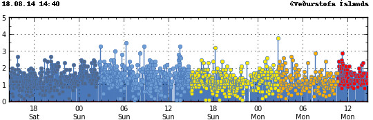
Earthquake activity has remained about the same, with regular fluctuation in activity. Overall however the activity has remained constant.
The earthquake activity in Bárðarbunga volcano. Copyright of this image belongs to Icelandic Met Office.
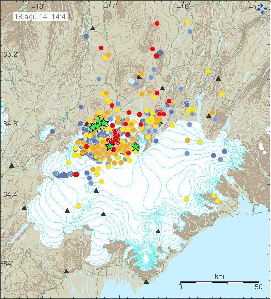
The earthquake activity in Bárðarbunga volcano has been migrating to the north-east over the past 10 to 18 hours. The activity close to Dyngjuháls appears to be stable at that location for the moment. Earthquake activity in other parts of Bárðarbunga have quieted down for the moment, that might change without warning.
Earthquake activity has remained stable in Bárðarbunga volcano. Copyright of this image belongs to Icelandic Met Office.
Harmonic tremor levels have remained stable since this started. They do drop a little in sync with the drop in earthquake activity.
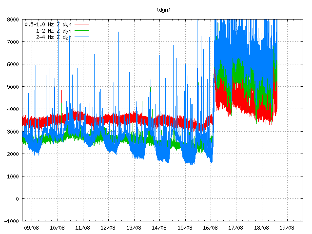
The harmonic tremor at Dyngjuháls SIL station. Copyright of this image belongs to Icelandic Met Office.
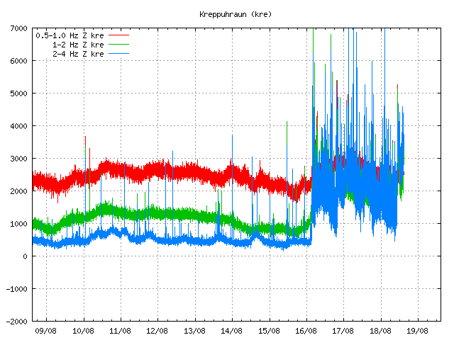
Kreppuhaun SIL station shows the harmonic tremor also. Along with interesting jump in the past hour of harmonic tremor activity. I am not sure why that is. Copyright of this image belongs to Icelandic Met Office.
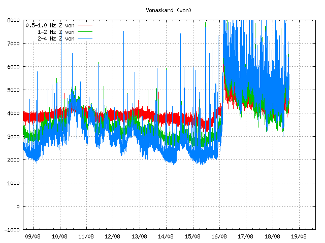
Vonaskarð SIL stations shows pattern that is close to what appears on Kreppuhraun SIL station. Copyright of this image belongs to Icelandic Met Office.
I am not sure why the harmonic tremor levels are what they are at the moment. Since no eruption has started. This might be due to changes in hydro-thermal areas under the glacier, or there might be some other reason for this that is not known to me.
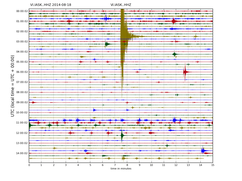
Drum plot that Icelandic Met Office has on-line are showing interesting activity. Around 11:00 UTC there is a string of earthquakes, following this activity a increase in harmonic tremor takes place. Copyright of this image belongs to Icelandic Met Office.
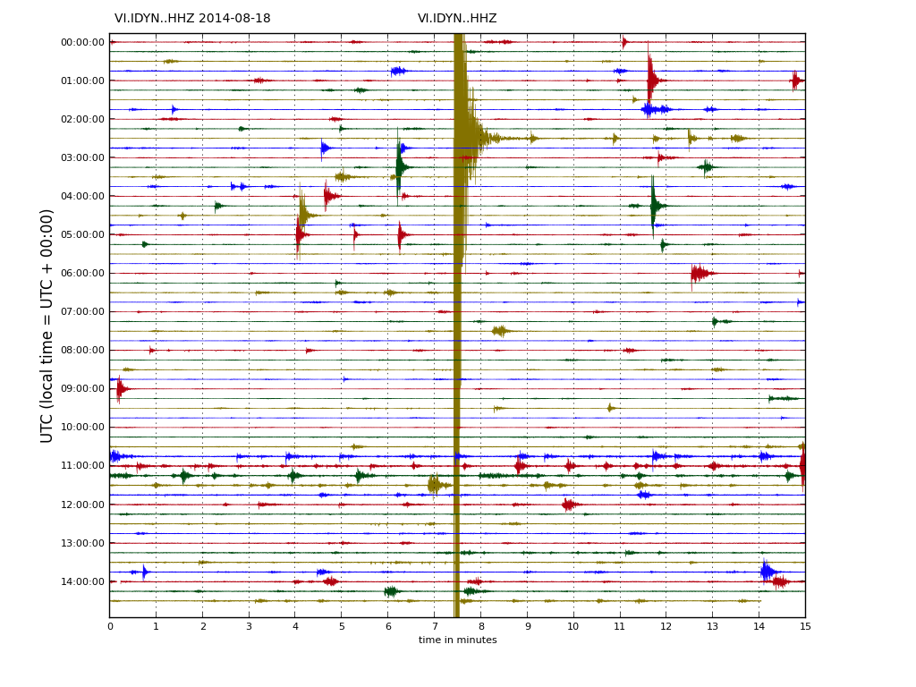
This can also be seen on Dyngjuháls SIL station. Copyright of this image belongs to Icelandic Met Office.

This also appears clearly on Kreppuhraun SIL station. Copyright of this image belongs to Icelandic Met Office.
As for amount of earthquake detected today, so far the amount recorded today is around the same as yesterday, might even be slightly higher.
Updated at 16:43 UTC.
Thanks for the update. You said the magma movement is fast. How long do u think it will take for it to reach the surfise? Thanks
It is impossible to know when the magma finds a pathway to the surface.
Thanks for the update. You said the magma movement is really fast. How long do you thik it will take it to reach the surfice? Thanks
Thanks for the update. You said the magma movement is fast. How long do you think it will take for it the reach the surfise? Thanks
So is in the phase for an imminent eruption?Is there available a webcam?
I don’t think there are any web-cameras for the public. You might try Grímsfjall web-camera to check if you see anything once a eruption has started.
The area is remote and there is no population in the area close to this volcano.
Live web cam for Bardarbunga Volcano set up today:
http://www.ruv.is/frett/live-webcam-of-bardarbunga-volcano
thanks
very odd situation all these days .I believe next days will show us interesting things. An explosion or a warning for a future situation
Jon what do you believe for this intense activity of the volcano?
Looks like the webcam view at Grimsfjall has been changed. Maybe now pointing towards Bardarbunga?
http://vedur2.mogt.is/grimsfjall/webcam/images//m140818173001915.jpg
Confirmed on Visir.is, the webcam has been pointed towards bardarbunga.
Looking at wx sat images, a major eruption would spread ash quickly over most of Europe. Keep this open all day and watch for a plume, if eruption happens.
http://www.sat24.com/en/eu?ir=true
What also seemed interesting to me when I looked at quakes across Iceland, is that there is really no other activity anywhere else except a little at Katla. Usually there is activity spread all over. Think something big is happening underground right now, and it’s focal point is around Bárðarbunga.
Hei Jon!
Thanx for your updates! I’m reading them everytime I’m online.
Please tell me the link of the drum-plots from IMO, you showed in this update.
I can’t find them at the IMO-page.
Best regards,
Daniel
ok, at least found it! 😀
You can find the drum plots here.
http://hraun.vedur.is/ja/drumplot/
so they are all ready for earth’s party
It’s like waiting for a kettle to boil!
Danish news speaks about possible eruption at Hekla… are they misunderstanding the situation or is something going on there as well?
Danish media got the wrong volcano. Far as I know, Hekla volcano is quiet and not doing anything at the moment.
I just posted this at Carl’s blog, and so I will also post here, because it might be of importance for people to read, and perhaps Jon can comment on it.
It is just some estimates using crude maths, so please consider my calculations are just approximate. Here it goes.
– – –
I can now tell you, at this level of activity, we still need to wait several weeks until we see a proper sized eruption. Unless a string of M5 quakes hits, then an eruption would just be hours away, if that number of M5 quakes is near 10 (or same equivalent cumulative seismic energy), or one M6 event or near that.
Why is this?
The GPS stations at both sides of the intrusion taking place at Bardarbunga show a lateral displacement of around 2cm per day (1cm/day in both directions).
During the last rifting event at Bardarbunga, the rifting displacement was around 1.5 meters (150cm) as the fissure opened, over some 15km. Let’s say we expect an event about half of it. To be on the conservative side. And 7km is just the same as Gjálp.
At this rate, we will need 35 days, to see a displacement of 75cm as the rift opens.
Total energy combined is probably equivalent to a M5. Until yesterday I calculated total energy to be about M4.5. Today it nears M5 (total cummulative seismic energy). That equates to a displacement of a few cms, which is what is actually taken place. Which is too little!
One M6 equates to a displacement of 50cm, so it is near what it is necessary to see such a fissure ripping apart of sufficient lenght; or a string of 10 quakes at M5.
Thus until this moment, only about 1/10th of the threshold energy has been released.
So this gives 10 times longer time, until we see an eruption of the type I assumed, if the current level of activity keeps.
But a few M5 quakes would quickly speed the process, to only a few days necessary.
So I predict to see either more 9 times of intrusions with the same sort of intensity (if such activity would now stop – which seems to be unlikely at the moment), or this intrusion continues for more 35 days (until mid September), or the energy increases until the level of several M5 or one M6 event (which at current level of increasing activity is just a few days ahead). If this intrusion continues for some more days but then dies down, then we would still need another one or few repeats of same intensity, until a fissure event.
Consider this the threshold.
Now, you know when to expect the start of the eruption.
Simple maths.
Steam at Kverkfjöll…
Daily business or something to have an eye on???
http://vedur2.mogt.is/kverkfjoll/webcam/index.php
Serious question!
There is always steam in Kverkfjöll, it has highly active hydro-thermal and hot-spring areas.
I am curious how they consider depth of these quakes. Considering that the actual surface of the volcano caldera is covered with 700 meters of ice, or 0.7km, I have noticed three quakes recently of >M2 at around 1 km deep. Is that depth measured from the surface of the glacier or from the bottom of it?
Hi Jon, I am watching all SIL station graphs and am noticing increased activity on some to the North and East of the current activity, whilst activity to the south and west falling. This would seem to be magma showing its movement over a widespread area whilst pressure is building in the bardabunga area. The askja SIL and Adalbol SIL show a distinct second jump in tremor around 11am yesterday – long after the M4.5 at 2.37am. The Vestari Asaudahnjukur SIL also shows this quite clearly.
How far can the magma travel from the chamber? Like, how far away from the active quakearea could a vent opens?
The fissure system in Bárðarbunga is up to 120 km long.
Is there a possible connection between the periodic earthquakes and tides?
http://www.tide-forecast.com/locations/Reykjavik-Iceland/tides/latest
No. There isn’t.