Update on the situation on Grindavík dyke intrusion

This is a short update, since the situation is changing quickly and without much warning. This just looks like it is quiet, it is not.

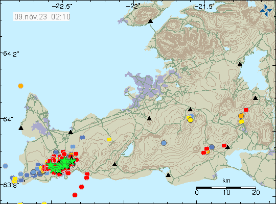
  • Grindavík town is sinking and parts of the town have lowered by as much 1 meter when this article is written. This is a large area, large enough to be called rift valley. This was reported by mbl.is here in Icelandic. This was just discovered today when some measurements where taken.
  • Magma might be as shallow as few dozen meters under the surface where it is the most shallow. This has been reported by mbl.is here in Icelandic. This is a live link and the news item in question might be removed or gone in few hours.
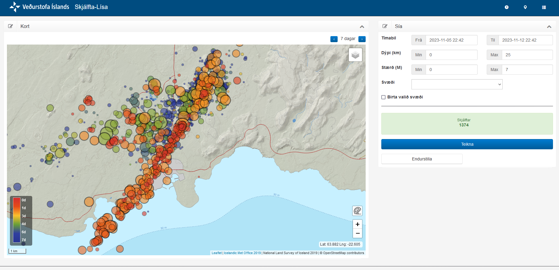
  • This is a event that was not expected. Most of the inflation until Friday 10. November 2023 had happened in Svartsengi (Reykjanes volcano) and in Fagradalsfjall volcano. There had nothing been happening at Sundhnúksgígar to the north-east of Grindavík. Until Friday 10. November at around 08:00 when a earthquake swarm started in that location. Originally it was though those where just tension related earthquakes, but that view (according to reports) changed early in the morning at Icelandic Met Office. Everything did go crazy in earthquakes between 16:00 until 19:00 on Friday. This earthquake swarm was really dense and many earthquakes with magnitude Mw4,0 took place inside Grindavík town.
  • There is damage in Grindavík, both roads and houses because of the displacement. Damages to pipes, electricity wires and other infrastructure.
  • The dyke seems to be few dozen meters wide and up to 1 meters deep. It might be different wide and deep at its 15 km length. I have not found any useful information about this. Just information on its length that was last time I checked, 15 km long.

This is not a small volcano event. What I don’t know and this doesn’t seems to be known. What volcano is causing this. This might be Fagradalsfjall volcano or this might be Reykjanes volcano.

String of earthquakes reaching from the ocean and under Grindavík town and to the north-east. This is the dyke that is causing a lot of problems in Grindavík. A lot of earthquakes to the west of this location. That is also having magma inflow. This is a map over seven day time period.
The earthquake activity over the last seven days. Copyright of this image belongs to Icelandic Met Office.

I’ll post more information about this when I know more or if anything more happens if I can.

Dyke has formed or is forming under Grindavík town, mandatory evacuation ordered

This is a short article. Its going to outdated quickly.

  • Dyke has or is forming under Grindavík town. This dyke starts at Sundahnjúkar in north-east of Grindavík town and is going to down to Grindavík. This is at the moment around 4 to 7 km long dyke. It might get longer and reach the ocean.
  • There’s a mandatory evacuation order in place. Everyone in Grindavík town has two hours (from around 23:00 UTC) to leave the town. Many people had already left because of the heavy earthquake activity today (10. November 2023).
  • Earthquake activity remains heavy, but is lower than it was at around 17:00 to 19:00 UTC. This might change again without warning.
  • GPS data suggests this is more magma than in all of last three eruptions combined.
  • This magma might be from Fagradalsfjall volcano. This is currently only an idea. That means the magma in Reykjanes volcano has not started to move to the surface. That might also happen without warning at any time, since that inflation continues.

I’ll post more information when I got them. The situation is unclear and there’s a lot of wrong information out there so check your sources.

Strong earthquake swarm in Reykjanes volcano

This is a short article. It might get outdated quickly.

Around midnight of 9. November 2023 an strong earthquake started close to Þorbjörn mountain, in the same area that has been having an earthquake and dyke intrusion since 25. October 2023. At the writing of this article, the largest earthquake had a magnitude of Mw5,0 and with a lot of smaller earthquakes taking place.

A lot of green stars and red dots close to Grindavík town on the Reykjanes peninsula in the volcano Reykjanes.
Strong earthquake activity in Reykjanes volcano. Copyright of this image belongs to Icelandic Met Office.

It is unclear if this earthquake activity is the start of the eruption or just normal inflation related earthquake activity. The magma is still at depth of 5 km. If it has started to move upwards trough the crust, it is going to take several hours to reach the surface. That means nothing might happen on the surface until late tomorrow or on 10. November at the earliest. Depending on how quickly the magma goes up through the crust.

I’ll post updates tomorrow if anything more happens.

Update on Reykjanes volcano activity

This is a short update and this information can go out of date quickly and without warning.

  • Earthquake activity continues in Svartsengi and close to Þorbjörn mountain. This earthquake activity is either tension earthquakes because of the dyke on either side (north-east and south-west) or in the dyke it self.
  • Inflation in Svartsengi and nearby area is extremely high and has been increasing much as 10mm a day in last few days.
  • There has been magma building up in the crust in the Reykjanes volcano since at least year 2020. It might have started few years earlier at more depth, but that is unclear.
  • There’s a risk of large eruption in this area, that might go on for few months in the worst case.
  • Largest earthquakes so far have had the magnitude of Mw4,7. Larger earthquakes remain a possibility.
  • It is impossible to know when a eruption starts or if it starts. But the likelihood of an eruption is extremely high.
  • Morgunblaðið reported that ground heat has been seen on thermal cameras. The news can be found about this here in Icelandic. There’s a YouTube video of this in both Icelandic and English (with more footage).

I’ll post new information about what is going on when it happens. As is, the situation does not change a lot from one day to another so I don’t have a lot to report on.

Magma movement close to Þorbjörn mountain this morning

Today (31. October 2023) at around 08:00 UTC an magma movement was detected by Icelandic Met Office. This started an earthquake swarm that had a largest earthquake with magnitude of Mw3,7. The magma seems to be at depth of 1,5 km where it is the shallowest. Few days ago, that magma was at depth of 5 to 8 km. This change is rather quick movement of magma, that suggests higher pressure compared the magma that erupted in Fagradalsfjall volcano. This might result in a larger eruption when it happens. The inflation at Fagradalsfjall volcano, south part of it has not lowered. The only thing that has happened there is that earthquake activity has dropped to almost nothing. Earthquake activity has moved to western part of Fagradalsfjall volcano. Eruption also happening in Fagradalsfjall volcano should not be ruled out, but the events close to Þorbjörn mountain might delay the progress of that magma.

Red dots and green stars north of Grindavík town, close to Þorbjörn mountain. There's also red dots west of Þorbjörn mountain and Grindavík town. Blue dots close to Reykjanestá on this map. Time on map is 31. Okt. 23 at 16:55 UTC.
Earthquake activity because of magma movements in Reykjanes volcano. Copyright of this image belongs to Icelandic Met Office.

It is difficult to know what is going to happen next. But an eruption is highly likely, when and where is almost impossible to know even if GPS data gives good clues on where it might happen. This situation is complex and it is uncertain what is going to happen next with this activity in Reykjanes volcano and Fagradalsfjall volcano.

I’ll post information soon as I know something. A list of web cameras of Icelandic volcanoes can be found on the YouTube page that I set up a while ago.

Inflation detected in Torfajökull volcano

Icelandic Met Office reported that inflation has been detected in Torfajökull volcano. This inflation started around middle of June. The inflation has now reached around 40mm.

Torfajökull volcano caldera. This image is purple to green from west to east. The centre of the Torfajökull caldera is shown with red colour to show the inflation.
The inflation of Torfajökull volcano. Copyright of this image belongs to Icelandic Met Office.

How fast this is going to evolve is difficult to know since last eruption took place in 1477 and that was probably an eruption as a result of magma injection from Bárðarbunga volcano. Last eruption in Torfajökull volcano it self might have happened last in the year 1170. Eruptions in Torfajökull volcano are almost always explosive eruptions with an dangerous ash cloud that drifts under the direction of wind.

Increased hydrothermal activity in Askja volcano

This is a short article about Askja volcano. Because I am getting information that are in my view slightly conflicting with each other.

It seems that an there has been a increase in gas and hydrothermal activity in Askja volcano and in nearby area because of inflation that is currently taking place. At the writing of this article the inflation in Askja volcano seems to have reached between 80mm to 100mm. The reports have been slightly difficult to place in a good picture of what is happening. That’s why I am limiting coverage about this until it becomes more clear to me what is going on.

The general advice from Icelandic Met Office is that people should not hike around Askja volcano or nearby area because of risk of gas and sudden eruption. There is no special earthquake activity at the moment and that makes it difficult to know what is going on. This might change without warning, as is sometimes the case with volcanoes.

Strong earthquake 1,4 km east of Keilir mountain

Today (9. July 2023) at 22:22 UTC an earthquake with magnitude of Mw5,2 happened 1,4 km east of Keilir mountain. This earthquake did shake Keilir mountain and resulting a small dust cloud. This earthquake is connected to inflation that is happening just south of Keilir mountain, rather than being connected directly to magma movements in this area.

A lot of green stars close to Keilir and Fagradalsfjall on Reykjanes peninsula map. Time on map is 9th July 2023 at 23:15 UTC.
Strong earthquake activity in Fagradalsfjall mountain and Keilir mountain. Copyright of this image belongs to Icelandic Met Office.

There’s a risk of more strong earthquakes like this in this area until an eruption starts.

Update on the activity in Fagradalsfjall mountain on 7th July 2023 at 14:28 UTC

This is going to be a really short article. Because an eruption might be about to start. Difficult to be sure, but there’s a chance. Eruption has not started at the writing of this article.

  • Largest earthquake in the last 24 hours seems to be a magnitude Mw4,3. I no longer can keep up with all this earthquake activity.
  • Inflation in area close to Keilir has reached 200mm (20cm) in less than 48 hours when this started.
  • Inflow of magma is estimated to be 88m3/s and that is a lot of magma moving and moving fast.
A lot of earthquakes in Fagradalsfjall mountain. Too many earthquakes too count and too many green starts.
Heavy earthquake activity in Fagradalsfjall mountain. Copyright of this image belongs to Icelandic Met Office.

It is unclear where the eruption is going to happen. But there has been a drop in earthquake activity that strongly suggest that magma is close to finding a path to the surface. According to measurements, the magma is now less than 1 km away from the surface.

Reykjanes peninsula might be one large volcano

It was in the news today (3. July 2023), since inflation has been detected from GPS data on Reykjanes peninsula since start of April. What was told in a interview on Bylgjan (radio channel) and later published on Vísir.is news website (link below, but the whole thing is in Icelandic) is that all of Reykjanes peninsula is inflating. What is also starting to show in the GPS data is that there might not be separate volcanoes on Reykjanes peninsula, this might also have happened in the year 2020 – 2021, before the first eruption in Fagradalsfjall mountain. All of Reykjanes peninsula might be one large volcano, extending from Hengill to Eldey or Eldeyjarboða, the south end might have uncertain location. This changes everything as that means that it can erupt at any location on the Reykjanes peninsula without warning and the whole area is now in an eruption cycle.

The current period of inflation started in April and is now at 2,5cm (25mm) and is centered at the last eruption location in Fagradalsfjall mountain. That means the most likely location of next eruption is going to be Fagradalsfjall mountain. This inflation is also going to trigger large earthquakes on Reykjanes peninsula in next few weeks to months until an eruption starts. Along with the normal amount of small earthquakes that have been happening since April on the whole of Reykjanes peninsula.

I don’t know when or how long it is going to take to change the official definition of the Reykjanes peninsula. Because this is going to require more research and data collection for the scientists in Iceland. This also means a lot of new science papers have to be published and peer-reviewed.

Icelandic news

Fólk á suð­vestur­horninu má búa sig undir reglu­lega jarð­skjálfta (Vísir.is)