
Today (20-May-2016) a magnitude 4,4 earthquake took place in Bárðarbunga volcano. This is the strongest earthquake so far since the end of the eruption in February-2015. This earthquake swarm also had two magnitude 3,3 earthquakes. Other earthquakes where smaller in magnitude.
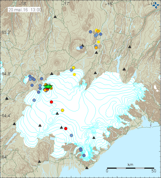
The earthquake activity in Bárðarbunga volcano. Copyright of this image belongs to Iceland Met Office.
Official statement from Iceland Met Office is that they are not sure what is going on. What is clear is that seismic energy being released from Bárðarbunga volcano has increased a lot since end of the eruption in February-2015 and current GPS data suggest rapid inflation. Both of are unusual after caldera collapse like Bárðarbunga volcano experienced in the 2014 – 2015 eruption. Due to lack of historical data it is hard to know for sure what is going on, whatever it is, it’s the first ever that is being monitored in great details.
Current events have not lead to an eruption so far. They however might do so in the future, when is difficult to know since the time frame of this development is unknown, it might be hours, it might be decades. Satellite images also show that cauldrons that have formed at the edge of the caldera are getting deeper and possibly larger, suggesting an increased hydrothermal energy at the locations where they have formed. This suggest that more magma is collecting at depth in the caldera, something as sad above is highly unusual due the recent caldera collapse in the last eruption. I’m expecting more earthquake swarms like this and growing magnitude of the earthquakes that take place. The weekly pattern is going to continue and I suspect it might increase soon, when is impossible to know for sure.
Donations
Please remember to support my work with donations (or by using Amazon). Currently my financial status is not so good (worse then what I was expecting). It will get better, just takes few months and I need to survive those months. Thanks for the help. 🙂
Hmmm it might be that bardarbunga is starting to preper it self for a magntiude 7 eruptioen mainly cause it was 15 kubick meter of magma left after the eruptioen end in 2015 and sicnes more magma is collectioencg will it be more likely that this eruptioen might cause icland to grow some meters and if its an ash eruptioen it woud be devesting espically if it woud be waves of pyroclastic flows and if an ash eruptioen does occure in the caldera locatioen and if the eruptioen is of magntiude 7 it woud be enough magma to producese a large ash field maybye even build new land masses along the easter and souther icelandic coastline pga ash downpore and pyroclastic flows doe its yust a theroye from me
That’s nonsense.
While VEI=7 eruption is not impossible, it’s highly unlikely to happen. Given that largest eruption in the past 10.000 years is a estimated VEI=6 (Veiðivötn, outside the main volcano in 1477). Your prediction is not realistic.
yur allowed to disagree jon frimann its wat i think
Looks like I look less of a fool with each passing week lol,some on the other blog must be choking on their cornflakes 😉
Easy JB lets wait until our chickens have hatched before get to carried away lol.
ON the other hand it is nice to get to gloat once in a while as well!
This does seem to be a fairly large jump in the activity at Bárðarbunga and the escalation of the strength definitely indicates something is up. Thanks Jon for keeping us informed.
I believe as soon as Iceland heading to summer ,the ice cap pressure reduces.It reminds me the pattern of 2014 eruption in the summer.There are more to come ,i guess .
I did record a earthquake on my geophone at Heklubyggð and Böðvarshólar. It appears to have happened on the Reykjanes Ridge.
Ok any idea what a – sign in front of an earthquake means for example this one in Nevada?
-0.2 58km N of Pahrump, Nevada 2016-05-22 19:49:19 UTC 4.2 km
What does it mean that the earthquake occurred at a depth of 0 km? How can an earthquake have a negative depth; that would mean it’s in the air. What is the geoid, and what does it have to do with earthquake depth?
An earthquake cannot physically occur at a depth of 0 km or -1km (above the surface of the earth). In order for an earthquake to occur, two blocks of crust must slip past one another, and it is impossible for this to happen at or above the surface of the earth. So why do we report that the earthquake occurred at a depth of 0 km or event as a negative depth sometimes?
First of all, the depth of an earthquake is usually the most difficult part of the location to nail down with great accuracy. Since most earthquakes are deep within the crust, an error of +/- 1 or 2 km is irrelevant; in other words, it is a small error when the depth is something like 13 km. If the earthquake depth is relatively shallow, however, it becomes more of an issue. A negative depth can sometimes be an artifact of the poor resolution for a shallow event.
For quarry blasts that are recorded by the seismic network, the depth is fixed at 0 km since we can never determine a precise depth for these, but we know they are very close to the surface.
Sometimes because of the density of the seismic network and the close proximity of the seismic stations to an earthquake epicenter, we are able to determine a very precise depth. When the earthquake depth is very shallow, it can be reported as a negative depth. This is where the geoid comes in; our earthquake depths are calculated using the geoid as a reference (or as the 0 km baseline) rather than the actual surface of the earth, which can vary. A virtual representation of the geoid looks rather like a misshapen rock instead of a perfect sphere or ellipse. The reference geoid that we currently use is called WGS84.
https://www2.usgs.gov/faq/categories/9828/3297
Sorry I think I should have been more clear with that readout it was the magnitude -0.2 that I was asking about I understand how a – can happen with distance readings but how do you get a negative reading on the magnitude reading?
The quake energy scale does not begin with a zero. A M0.0 quake is not zero in energy, it has a certain energy release, and as you go up on the scale, M0.3, M0.7, and so on, the released energy increases by a certain amount. It is the same when going below zero. The released energy reduces down by the same “percentage” in minus by which it increases in plus. So esentially, negative magnitudes release as much energy as a Big Mac, but can be detected with sophisticated equipment.
There was a post about this, earlier in the year. 0 km is sea level, so as Bard is several 1000 mt high you can get a negitive reading when the earthquake takes place near the surface
Big quake just now http://hraun.vedur.is/ja/drumplot/drumplot/dyn_highpass_2.0.png
Not 100% cheked yet:
Monday
23.05.2016 17:37:48 64.610 -17.349 1.1 km 3.0 90.07 9.2 km ESE of Bárðarbunga
Monday
23.05.2016 17:37:47 64.619 -17.413 0.3 km 3.4 99.0 6.0 km ESE of Bárðarbunga
Luisport, do you have a link for the live drumplots? I haven’t been able to find them
The complete list can be found here:
http://hraun.vedur.is/ja/drumplot/drumplot/
Thank you
There is going to be an article tomorrow about Bárðarbunga volcano. Not the normal earthquake article, since the activity is almost the same between weeks at the moment.
Computer problems are delaying the article for few hours. I ran into problems with KDE 5 and I’m removing it and re-installing KDE 4.
Anyone knows what’s going on in last hour? What is this sismic signal? http://hraun.vedur.is/ja/drumplot/drumplot/dyn_highpass_2.0.png
Dyke intrusion in Bárðarbunga volcano. It appears to be rather large. A storm in Iceland is making it difficult to locate any small earthquakes at the moment.
It’s interesting that the activity is concentrated 17.0 km ESE of Bárðarbunga and some on Grímsfjall http://en.vedur.is/earthquakes-and-volcanism/earthquakes/vatnajokull/#view=table
The activity in Grímsfjall volcano is not connected to the activity in Bárðarbunga volcano. It is interesting, due the fact that Grímsfjall volcano is highly active and its now five years since last eruption took place.
I am really starting to think that Grismfjall volcano is starting to wake up. Bardarbunga and Grimsfjall areas are very active currently. That is for sure.
This would seem to be a nasty time to have either Bárðarbunga or Grímsfjall volcano being active with the spring run off of snow melt happening, all that extra moisture is going to leave a greater chance of creating more havoc I would think!