
Bárðarbunga volcano continues it earthquake activity and it has now been a year since the eruption in Bárðarbunga volcano ended in Holuhraun (article I wrote about it can be found here). This activity (image) took place on 2-March-2016.
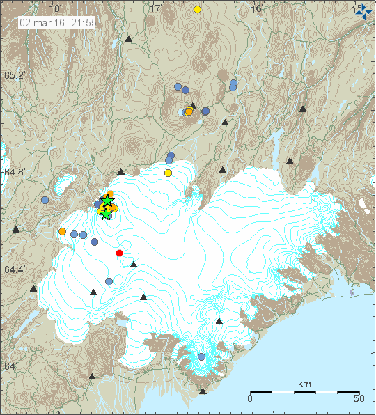
The earthquake activity in Bárðarbunga volcano. Green stars are earthquake with magnitude above 3,0. Copyright of this image belongs to Iceland Met Office.
Largest earthquakes in this swarm had the magnitude of 3,1, 3,3 and 3,6. Other earthquakes where smaller in magnitude. The reason for this earthquake swarm seems to be a developing weakness in the north and western part of the caldera. Activity in south part of the caldera seems to be crust adjustment to this weakness (stress changes). The weakest area is long one (I didn’t find information on how large the caldera is, but it is large). This weakness is going to continue to develop until an eruption happens or the magma finds it self a new path and that is more likely than an eruption taking place in the caldera rim, however I cannot rule out an eruption in the caldera at this point. This is all just wait and see situation at the moment. Interesting earthquake also took place in Hamarinn volcano, it had the depth of 13 km and magnitude of 0,7.
Deep earthquakes also took place in Tungnafellsjökull volcano. That earthquake had the magnitude of 0,8 but depth of 17,9 km. Suggesting that some stress changes at depth are taking place. In this case I doubt magma created the earthquake.
If an ash eruptions takes place in Bárðarbunga volcano, the resulting ash fall would be devastating (besides the following glacier flood). Last time larger eruption took place in 1477 half of Iceland got covered in volcano ash (that’s 50% of land), the volcano ash eruption in 1711 covered north Iceland and large parts of east Iceland. In 1711 to 1729 total of nine glacier floods took place and the source of them is believed to be Bárðarbunga volcano. Glacier floods from other volcanoes (Grímsfjall, Kverkfjöll, Þórðarhyrna, Hamarinn) are also highly dangerous. The volcano ash had thickness up to 100 meters next to the eruption area in 1477 (see map in link 1).
Source 1: Hvaða tjón gæti mögulega hlotist af gosi í Bárðarbungu? (Icelandic)
Source 2: Hvað eru mörg gos þekkt í Bárðarbungu og hefur orðið mikið tjón af þeim? (has gravity map of Vatnajökull glacier, Icelandic)
Lets hope that Bardy will hold off till you are safely in Denmark, I remember the chaos that Mt St Helen’s caused with only a few centimeters of ash. Speaking of ash fall do you have a good respirator/mask just in case. Living that close to the action you should have those kind of things close at hand, we lost both the elderly gentlemen neighbours within months of St Helen’s blast and we only got 2 centimeters of ash where we were living at the time. They refused to put masks on and it really compromised their already bad lungs ( both were former smokers but still ) it was not a nice way to go.
The map on source one has depth map of the volcano ash (estimated I guess). As you say, just few centimeters are a big problem. Few meters like the ash fall in 1477 must have been awful.
Whats Bardy? I didn’t know Iceland had a volcano or glacier by that name.
It would be nice if everyone had the courtesy to respect the language of the region theu are interested in reading and commenting about
Hey matt, are you a little hungry? Here have a sneakers bar. After all, long time posters use their pet nicknames, and everyone knows what they mean with no disrespect for any particular demographic.
Please remain calm. Not everyone has been here for a long time. I always use the proper names in my articles regardless of names used in comments.
So there is no reason to worry about this or to get upset about this.
I was only trying to be funny, no need for worry. 🙂
Sorry Matt I have enough trouble typing as it is without having to try and do Bárðarbunga every time so I have been using Bardy my fault got lazy didn’t take the time to copy and paste the full name.
Thanks Jack
Okay I understand. I just encounter enough destruction and corruption of the english language in my backward country of australia let alone us english speakers chewing up other peoples native tongues. Mountains and Volcanos are sacred and spiritual as their names.
Thanks Gary I don’t know what a sneakers bar is but yes I was hypoglycemic at the time. Incidentally I’ve been closely following this blog for a very long time just never got around to sharing my feelings about language before
Thanks Jon
@ Matt Australia:
I could imagine that a “Snickers” bar is meant in this case. 😉
It all depends on the wind direction at the time of such an ash eruption. Ashfall is likely to spread over a large part of the mainland due to the prevailing easterlies.
Was there ever an thorough scientific analysis of the events of 2014/2015,since 8ts been almost a year since the end of the eruption.It seems like this has not happened or maybe I missed it.
Yes. I’m going to write a article about it few hours. There was a news coverage about it at Stöð 2 (Channel 2) earlier this evening. Not all the details, just few of them.