
This is a short update. I am still a little sick (sigh) so it’s a bit hard for me to work properly.
Information here is going to get outdated quickly and without warning.
Few short points on current activity in Bárðarbunga volcano.
- Earthquake activity is high today (22-August-2014). There is less earthquake activity today than was yesterday (21-August-2014).
- Dyke formation continues at depth of 5 to 10 km. The push north seems to have stopped or slowed. Currently it is estimated that the dyke is getting wider. There also less resistance in the crust (appears to be), leading to fewer earthquakes taking place. This dyke is now estimated to be 25 km long.
- Bárðarbunga caldera appears to have given away due to less magma holding it up. As magma has flowed into the dyke. It is now estimated that 200 million m³ of magma has flowed into the dyke.
- Inflation so far is 20 cm according to news on Rúv with information from Icelandic Met Office.
- So far around 5000 earthquakes have been recorded since this activity started on 16-August-2014.
There are also signs that this might be a start of a new eruption cycle for Bárðarbunga volcano. Not all events in this cycle are going to lead to an eruption. This is the same pattern as took place in Krafla volcano during it’s eruption cycle [Wikipedia information, University of Iceland information]. It remains to be seen if this idea is true in part or whole.
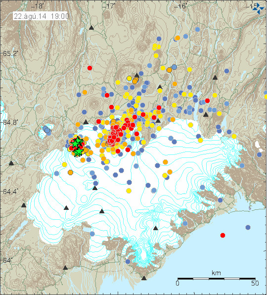
There is less earthquake activity today then yesterday. Copyright of this image belongs to Icelandic Meteorological Office.
Earthquake activity remains stable, it goes up and down and currently there has been less activity then yesterday (21-August-2014).
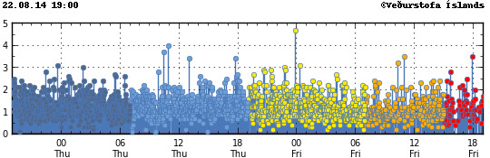
Less earthquake activity clearly shows on IMO earthquake graph. Copyright of this image belongs to Icelandic Meteorological Office.
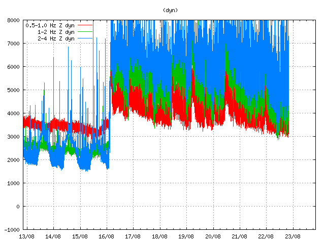
Harmonic tremor remains high even during less earthquake activity. The high harmonic tremor is most likely taking place due to magma inflow under ground. It does not appear to be connected with earthquake activity (for most part). Copyright of this image belongs to Icelandic Meteorological Office.
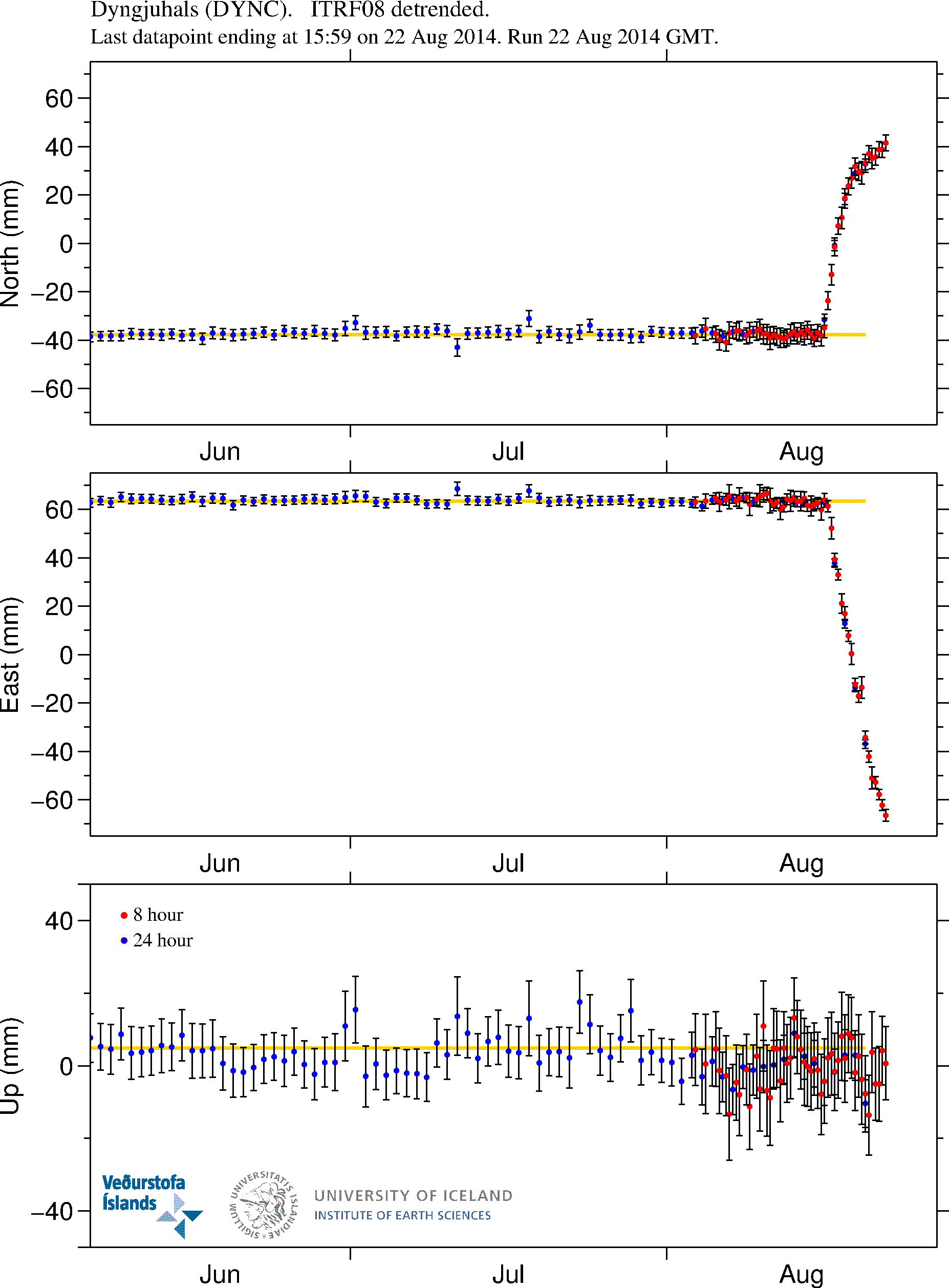
GPS data clearly shows the inflation that has been taking place in Bárðarbunga volcano. Inflation to the north has slowed down, while inflation to the west continues. More GPS information can be found here. Copyright of this image belongs to University of Iceland.
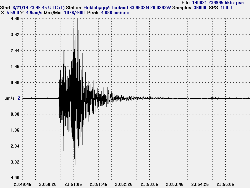
The magnitude 4,7 earthquake as it appeared on my geophone in Heklubyggð. This image is released under Creative Commons Licence. Please see CC Licence page for more details.
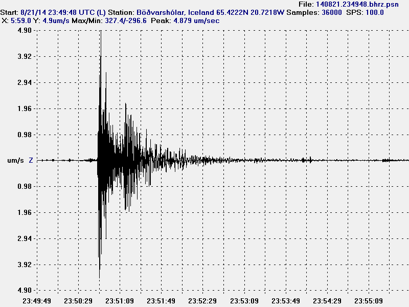
The magnitude 4,7 earthquake as it appeared on my geophone in Böðvarshólar. This image is released under Creative Commons Licence. Please see CC Licence page for more details.
Largest earthquake so far is an magnitude 4,7 earthquake (EMSC information here) that took place yesterday (21-August-2014). A magnitude 4,3 earthquake (EMSC information here) took place today (22-August-2014) at 15:41. This strong earthquakes happened due to the lowering of the caldera as explained above. If the dyke intrusion continues, more earthquakes are going to start happening. It is not known how much magma, if any is coming from depth (mantle depth) at current time with lack of deep earthquakes in all this activity, it is impossible to know if any magma is coming up from the mantle.
News in English
Met Office: 25 km long dike formed (Rúv.is)
Strongest earthquake yet in Bardarbunga (Rúv.is)
Updated at 21:17 UTC.
Updated at 21:19 UTC.
Updated at 21:41 UTC.
Updated at 23:22 UTC.
Many thanks for doing this when you are not feeling well, your efforts are greatly appreciated.
Yes – thanks for keeping us updated.
I guess such dykes are pretty normal and not a sign of a possible fissure eruption? I think, and hope, that the magma there isn’t as poisonous as Laki’s if such a thing were to happen.
Stay safe and get well soon!
G’day Jon,
I watch your site with a great interest. I am from Iceland originally and am therefore even more interested in these events.
Thank you for keeping us all informed and especially when you are not well.
I was wondering if the 20cm inflation of the glacier and the subsidence of the caldera under Bardarbunga are linked? It seems logical to me that if there has been a 20cm inflation, pressure may have dropped somewhat and therefore the bottom of the caldera would have subsided.
Do you think these events increase the odds of eruption or is it really too early to tell?
They are linked. As magma flows out from the magma chamber into the dyke it lowers the pressure inside the magma chamber. That means there is less to hold up the caldera floor, so less pressure means it drops a little. So far the drop is just few centimetres or less.
Thank you Jon for this clear and succinct update – much appreciated – best wishes
Quakes seem to have slowed a little. I wonder if pressure is building ?
Hi Jon,
The lunar cycle is putting a new moon up in two days when the gravitational pull on earth will be at its greatest (creating the highest tides). I am wondering if these cycles we are seeing in seismic activity are linked and whether the lunar/solar alignment in two days will make things worse. It is of course building towards that now as the tides increase so does the force.
Hi Scots John,
here are two really nice and interesting articles about the moon and earthquakes from Erik Klemetti (read them one after another 🙂 ):
http://www.wired.com/2013/05/looking-for-patterns-in-earthquakes/
http://www.wired.com/2013/05/earthquakes-patterns-and-predictions/
🙂
LOL yes, I could not see a pattern and was beginning to think my idea was rubbish until it revealed the ruse.
I brought the subject up since the clear harmonic tremor show at some SIL’s appears to coincide.
Whilst were on this have you looked at http://www.livefromiceland.is/webcams/bardarbunga today?
I know it’s common to see dust movements, but there are two areas to the righ and one in centre which appear to be issuing steam. Are these known hydrothermals? Ive been watching for ages and they are coming from the same areas of ground.
I think everyone is looking at this webcam…can’t get connection…
Hey John, appreciate your work ethic there. Two remarks:
(1) I struggled with the idea the caldera was actually sinking when first saw it suggested by Kristín Vogfjörð from the Met Office (good call!), but the CGPS does suggest a compressive and slight rotational and slightly north and easterly trend in the southern three sites. So I expect Kristin has this displayed in a 3-D model and it would be hard to miss the implications. Plus DYN has the southerly component now, and the drop can’t be due to net extension of the caldera. So yes, the caldera slumped a little. Hadn’t expected that.
(2) The quakes have gotten deeper, and the deeper quakes have gotten larger in the most plastic region, predominantly under the base of the fissure swarm, suggesting a pressure drop there after those recent quakes and material is now moving up from 15 km more freely. Hence the slight fall in quakes. It is making sense at this point (but probably proven wrong tomorrow)
I’m surprised by the volume involved and the apparent depth and width of it. Must go read you link on Krafla now. But thank you for your thoughts, observations and links, that’s quite a volcanic province you have there and the local data flow is outstanding.
John head’s up! There is a sudden swarm of significantly larger quakes in the fissures length. It looks like its going.
http://baering.github.io/
Looks like something is starting!! Nothing big I hope.
Can see lots of old ash blowing, but no obvious eruption yet.
Looking at Mila camera either the wind has got up and blowing more old ash, but I must admit it looks a bit more than that now!
Do we have an eruption?
Looks like steam from melt water!! All happened as I watched over the past 30 minutes. Amazing this internet technology.