Deep earthquakes in root of Eyjafjallajökull volcano

Today (30-June-2016) three earthquakes took place in the root system of Eyjafjallajökull volcano I think. The most depth for those earthquakes was 14,3 km and the most shallow one 1,3 km. The largest magnitude was 1,1 the other two earthquakes had the magnitude of 0,7. Nothing to worry about magnitude wise.
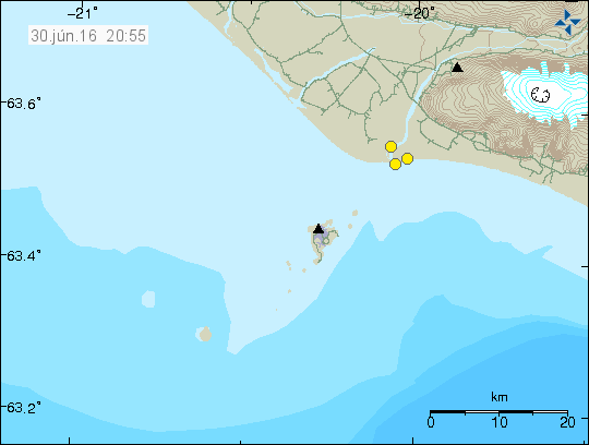
160630_2055
The earthquake activity close to Eyjafjallajökull volcano (three yellow dots). Copyright of this image belongs to Iceland Met Office.

Eyjafjallajökull volcano extends to this area, however at this area there are no surface craters. If there where they are long lost due to erosion. Unlike many other volcanoes, Eyjafjallajökull volcano does not have an extensive fissure swarm extending outwards for it, that should limit the path the magma can travel in theory. While I am not expecting any type of eruption from Eyjafjallajökull volcano in near future. If this earthquake activity continues I might have to review that outlook. I don’t expect this earthquake activity to continue, since next eruption in Eyjafjallajökull volcano won’t happen (based on my model) until the year 2199 at the earliest.

It is also question of this earthquake activity belongs to Vestmannaeyjar volcano system. Over the past few years deep earthquakes have been taking place there at regular time. Not many, just one or two at the time.

Strong earthquake swarm deep on the Reykjanes ridge

Few days ago an earthquake swarm started deep on the Reykjanes Ridge, this is as far as the Reykjanes ridge extends at the end of it. After that the north Atlantic ridge starts. It is close to impossible to know for sure what is going at this location, however the data suggests that an eruption is taking place there and it appears to be a big one. How big I don’t know and I’m not willing to guess it due to lack of data.

The earthquake activity has been interesting, with the largest earthquake having a magnitude 5,5 (EMSC info). Other earthquake magnitudes are 4,9 (EMSC info), magnitude 5,0 (EMSC Info), magnitude 4,9 (EMSC Info).

This earthquake activity is currently ongoing, since the distance from land is ~1100 km it is impossible to know for sure what is going on. There is also around 4 km deep ocean at this location. If an eruption is taking place at this location, it is not going to show in the surface of the ocean. I’m sure a lot of smaller earthquakes are taking place, they are just not being recorded by any seismic detecting network due to distance.

Something is going on in Bárðarbunga volcano

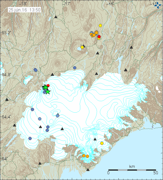
This is little short on details as of yet. There is clearly something going on in Bárðarbunga volcano. I don’t know what at the moment, several earthquakes have appeared, the strongest one with the magnitude of 4,0 so far. I’ll post more updates soon as I know more.

160625_1350
The earthquake activity in Bárðarbunga volcano. Copyright of this image belongs to Icelandic Met Office.

No volcanic harmonic tremor has been seen as of yet. That means no eruption for the moment.

Magnitude 3,2 earthquake in Torfajökull volcano

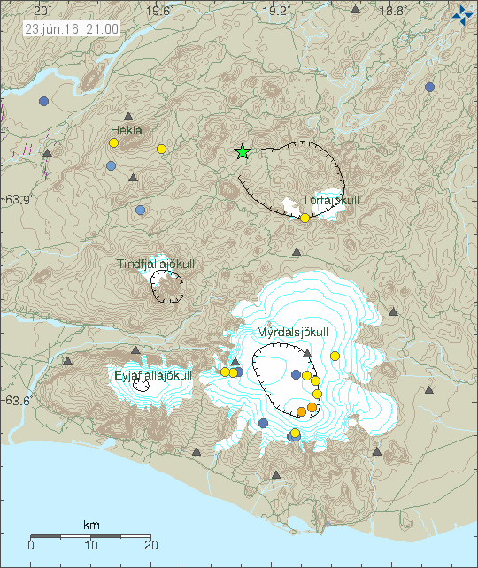
Today (23-June-2016) at 20:36 UTC an magnitude 3,2 earthquake (current data, might change) took place in Torfajökull volcano. The depth was 2,1 km.

160623_2100
Green star in Torfajökull volcano shows the location of the earthquake. Copyright of this image belongs to Iceland Met Office.

If anyone was close to this earthquake, it would have been felt. No other earthquake have so far followed this earthquake, that might change in few hours. It does happen once in a while that just one magnitude 3,0 earthquake happens and nothing more. I don’t know if there is any hydrothermal activity in the location where this earthquake took place.

Update at 22:24 UTC

According to an announcement from Iceland Met Office. This earthquake was felt in a nearby camping area.

Article updated at 22:24 UTC.

Bárðarbunga volcano continues to inflate, gas readings unchanged

According to news report on Vísir.is (Icelandic), it appears that Bárðarbunga volcano is continuing to inflate at the same rate as it has been doing since the eruption ended in Holuhraun in the end of February 2015. Gas measurements from cauldrons that formed on the caldera rim during the eruption in 2014 show that gas output from Bárðarbunga volcano have not dropped during the last year and continue to be high. The glacier drop that formed during the eruption is now almost full of new glacier and snow from last winter. Nothing suggest that water has been collecting at the caldera bottom during the last two years.

The research trip to Bárðarbunga volcano was taken during the days of 3 – 10th of June. A new seismometer was also installed on the caldera rim. I don’t know if it’s a SIL station or not. If it is, it is going to appear soon on Iceland Met Office website.

Minor glacier flood from western Skaftárkatlar cauldron

Few days ago a glacier flood started from western Skaftárkatlar cauldron. Due to how short time it is since last time glacier flood took place from the western cauldron a major glacier flood is not expected. No damage is also not expected from this glacier flood due to how small it is.

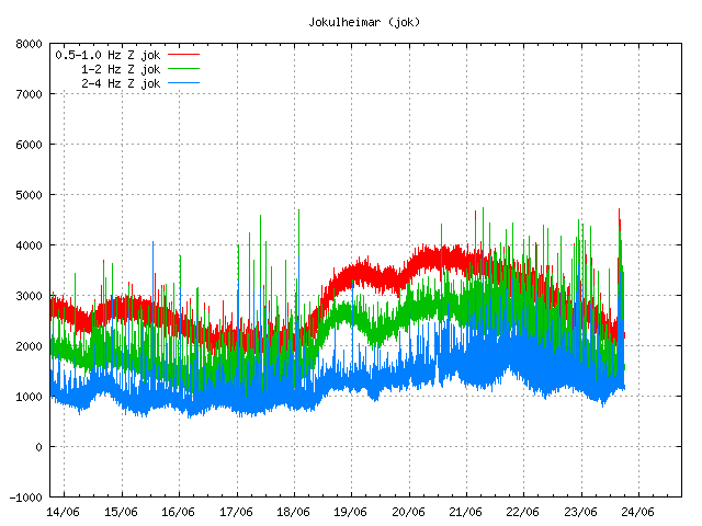
jok.svd.23.06.2016.at.19.57.utc
Harmonic tremor disturbance due to the glacier flood from western Skaftárkatlar cauldron. Copyright of this image belongs to Iceland Met Office.

When the water pressure is released from the hydrothermal area that powers this cauldron, a spike in harmonic tremor is normally seen on nearby SIL station. The reason for this is unclear, with leading ideas that magma moves in the hydrothermal system when the pressure drops. The image above shows such harmonic tremor spike taking place at Jökulheimar SIL station. Eruption is not expected to happen due to this glacier flood, what happens is impossible to know for sure. Normally nothing more than just harmonic tremor spike happens.

Deep earthquake activity in Katla volcano

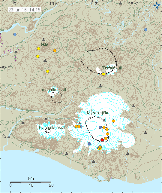
Today (23-June-2016) a deep earthquake swarm took place in Katla volcano. None of the earthquakes that took place where strong, but many of them where deep. The deepest earthquake had the depth of 28 km, at this depth it’s only magma that creates earthquakes.

160623_1415
The earthquake activity in Katla volcano. Copyright of this image belongs to Iceland Met Office.

Other interesting feature that showed up is a dyke intrusion in the caldera wall to the south, it is located almost directly north of Vík í Mýrdal village. This dyke intrusion appeared in 2011 after the minor eruption in July that year (this is my view, at the moment it has not been approved by scientists). It is unclear how this dyke intrusion is evolving, but there might be some risk of eruption from it if the pressure increases. Currently there is nothing that suggests an eruption is about to happen.

Minor earthquake swarm on the Reykjanes peninsula

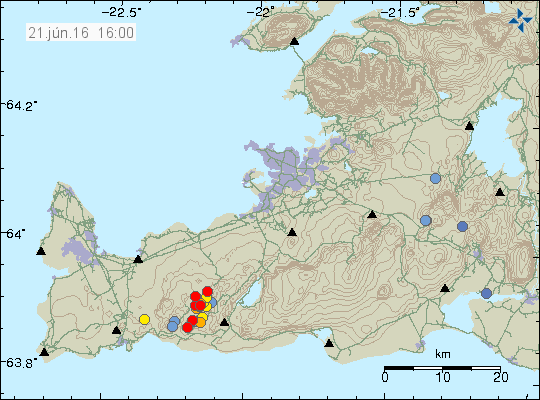
Today (21-June-2016) a minor earthquake swarm took place on Reykjanes Peninsula, this earthquake swarm was located close to a mountain called Keilir. This was not a large earthquake swarm, around 20 earthquakes took place.

160621_1600
The earthquake swarm on the Reykjanes peninsula. The earthquakes are the red dots. Copyright of this image belongs to Iceland Met Office.

None of the earthquakes that took place was strong, with the largest earthquake only having the magnitude of 2,2. Other earthquakes that took place had smaller magnitude. This earthquake activity appears to have died out (for now at least).

Increased activity in Öræfajökull volcano noticed

It has been noticed that earthquake activity in Öræfajökull volcano is slowly increasing. At the moment this increase is just in the form of minor earthquakes taking place in the volcano at 5 – 10 km depth (at the moment). This was covered in a Icelandic news two days ago (when this is written), the volcanologist in the news (Páll Einarsson) says this is nothing to worry about at the moment, that I agree with, mostly, he also put forward that idea this process, if it evolves into an eruption might take up to 18 years from start to finish, as was the case with Eyjafjallajökull volcano. This is where I disagree with the professor Páll Einarsson, the reason being that this process already started good 10 years ago, I also suspect that Öræfajökull volcano to be a volcano that erupts suddenly and with a lot of force once it does erupt.

The eruption in the year 1362 had the VEI of 5 and the eruption in 1727 had the explosive force of VEI=4. Both eruptions lasted several months. Öræfajökull volcano only makes ash rich, explosive eruptions, based on latest historical data and studies into the volcano history. The processes that power Öræfajökull volcano might also be different, since there is an slab of old continental crust (study: Continental crust beneath southeast Iceland) under Öræfajökull volcano, that is slowly melting due the nearby hotspot. This means the magma is mostly silica, not far from the magma found in volcanoes found at subduction zones around the world.

There is also a second volcano this same area that has been showing sign of increased activity. That volcano is called Esjufjöll, it has even less understood activity (if any) since people moved to Iceland ~1300 years ago. There is a chance of an unconfirmed eruption in the year 1927, but it didn’t last long, maybe up to five days, it was mostly noted due a glacier flood from the area this volcano is located (small according to historical documents).

Earthquake on the Reykjanes ridge

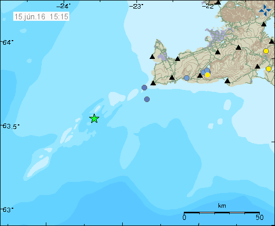
Today (15-June-2016) at 12:51 UTC an earthquake with the magnitude of 3,3 took place at Reykjanes ridge.

160615_1515
The earthquake on the Reykjanes ridge. Copyright of this image belongs to Iceland Met Office.

Only one earthquake happened and no other activity has appeared on the Reykjanes ridge following this event. There is a good chance that no further activity is going to take place in this area for the moment.