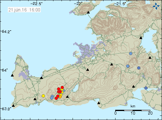
Today (21-June-2016) a minor earthquake swarm took place on Reykjanes Peninsula, this earthquake swarm was located close to a mountain called Keilir. This was not a large earthquake swarm, around 20 earthquakes took place.

The earthquake swarm on the Reykjanes peninsula. The earthquakes are the red dots. Copyright of this image belongs to Iceland Met Office.
None of the earthquakes that took place was strong, with the largest earthquake only having the magnitude of 2,2. Other earthquakes that took place had smaller magnitude. This earthquake activity appears to have died out (for now at least).

There’s a scary / sensationalist article about Hekla being ready for some action and airline
routes being at the wrong place. In Berlingske today.
http://www.b.dk/globalt/island-holder-vejret-porten-til-helvede-er-klar-til-at-aabne-sig-paa-ny
Any comments?
there seems to be some news about Helka according to Páll Einarsson
whats true about this story ?
https://translate.google.nl/translate?hl=nl&sl=is&tl=en&u=http%3A%2F%2Fwww.visir.is%2Fnyjar-maelingar-syna-ad-hekla-er-tilbuin-ad-gjosa%2Farticle%2F2016160618847
Seems to still be jumping around ! Good update thought thanks Jon!
In the Dutch media: Hekla is about to erupt according to an Islandic professor. I also read this somewhere on Facebook last week. But you are not mentioning it. Do you think they are wrong? I am really curious about your opinion, thanks!
I also wonder if you have any view on the news about Hekla? Perhaps you are still be at the information gathering stage, though.
There is no news about Hekla volcano. This is mostly media hype, Hekla volcano is ready to erupt, that is the same status on the volcano from few years ago.
Currently there have been no change since 2014. When I wrote this articles.
http://icelandgeology.net/?p=4337
http://icelandgeology.net/?p=4324
Hekla volcano is ready to erupt, but that is not really news since Hekla volcano has been ready to erupt since 2010.
There is now a minor glacier flood from Mýrdalsjökull glacier (Katla volcano). This glacier flood is due to cauldron emptying it self, this happens on a regular basis during the summer. This is also the result of heavy rain in the area for the last few days. Not worthy of special article at the moment.
Please remember to donate if you can. Thanks for the support. 🙂
But worth a reply with a link. 🙂
http://www.ruv.is/frett/minnihattar-jokulhlaup-i-mulakvisl
Earthquake at Trölladyngja, depth 17,4 km. This is my current most area of interest around Bárðarbunga volcano. Since my maths says it has the highest probability of erupting in the near future if this activity continues to develop as it has been doing for the last two years.
For those interested,
Up to date Iceland quake map highlighting the last 15 days
https://vatna.cartodb.com/viz/b765b472-3869-11e6-9b2c-0e31c9be1b51/public_map
Hey Jon and followers. Is there a map with all of these different volcanos spelled out
Yes, but its on paper and you have to order it from Iceland.
Map, http://www.eymundsson.is/nanar/?productid=ffe411f3-f33b-4d16-a20b-7f99b49aceb0
The price is $15,81 / 13,81€ and I think you can order it from Iceland and have it sent to your country with the mail.
Here is a web map, it needs Flash to work. Once it has loaded move cursor to ‘basemap’ and select ‘map with placenames’. http://atlas.lmi.is/kortasja_en/
Trölladyngja is just north of Bardarbunga.
And a minor intrusion under Katla?