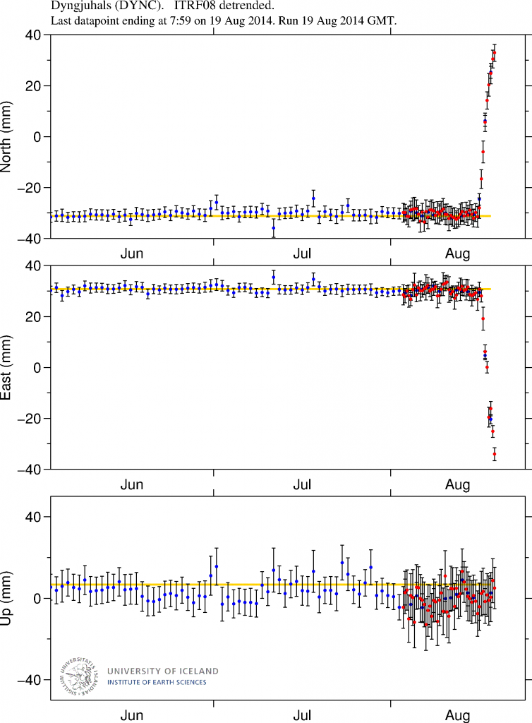
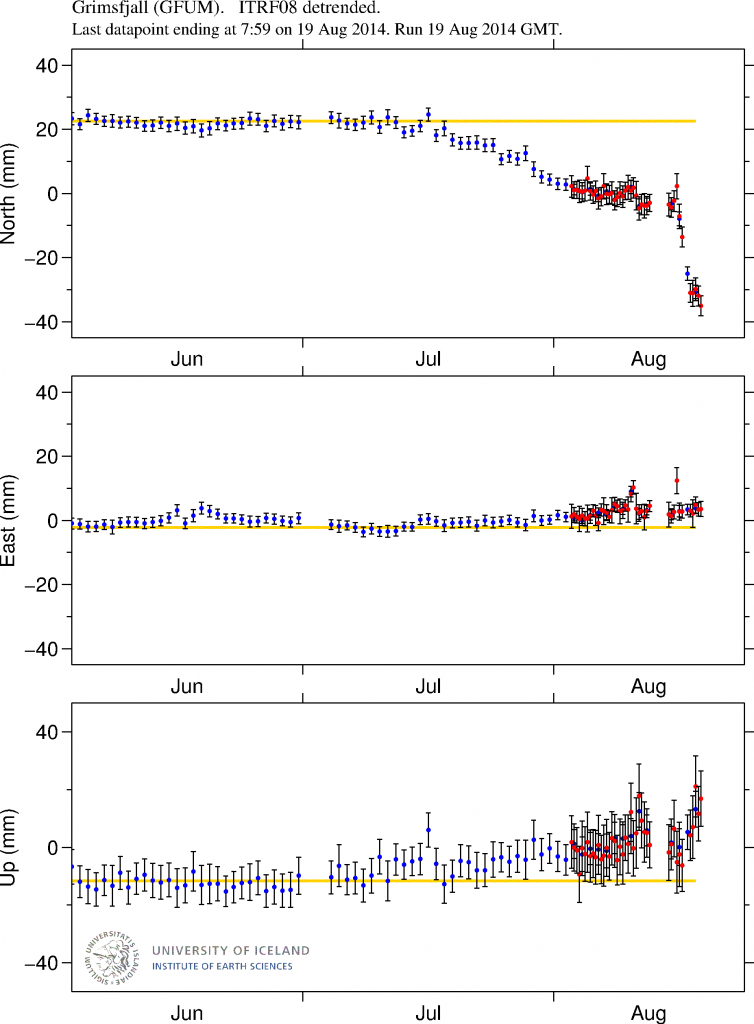
Short update Bárðarbunga volcano at 17:52 UTC

This is a short update on current status on Bárðarbunga volcano.

Uncertainty level has been declared on Bárðarbunga volcano and it status has been raised to yellow. There are fluxuation in earthquake activity, this is normal since earthquake activity in volcanoes is never close to constant in this type of situations. There is also a storm taking place in the area at the moment, that is lowering what is detected by the SIL stations that are close to Bárðarbunga volcano.

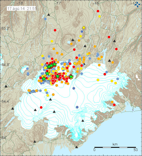
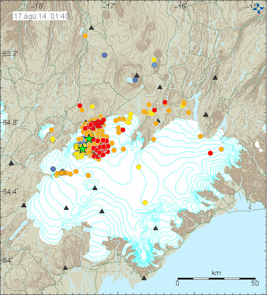
140816_1705
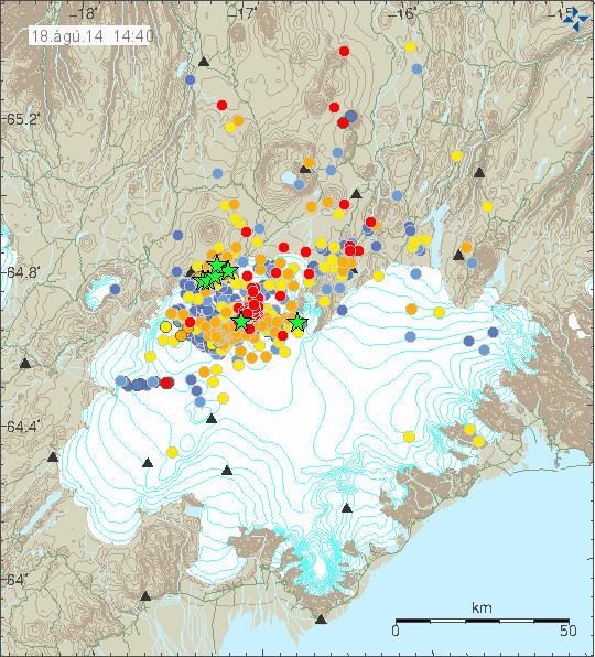
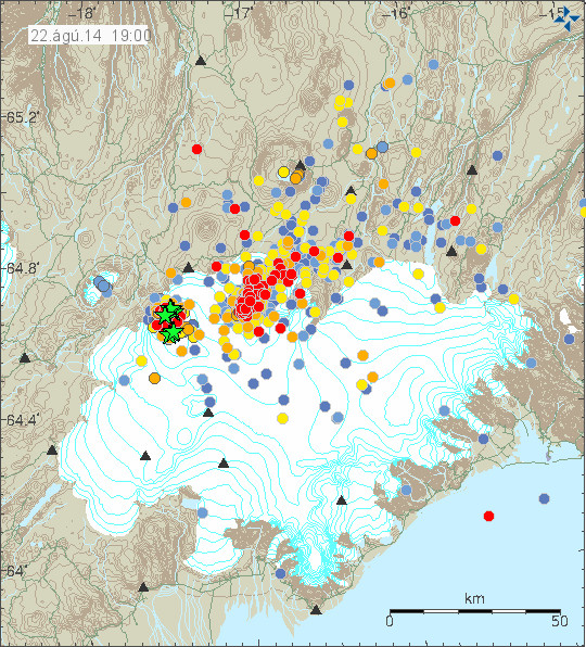
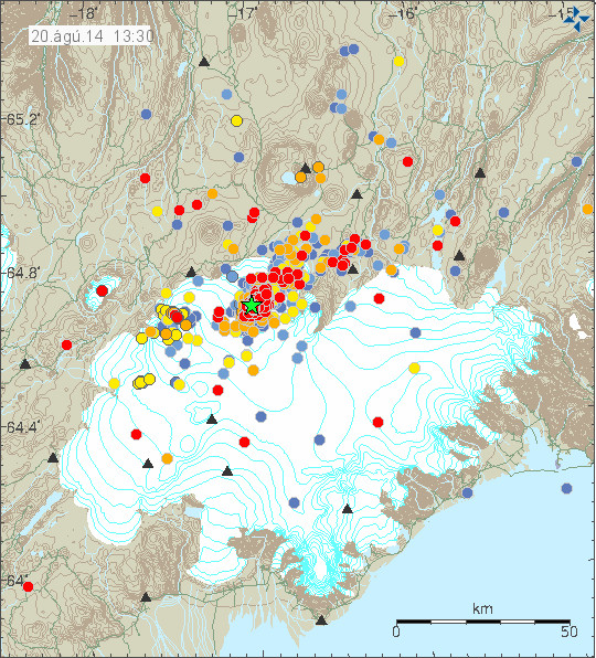
The earthquake activity in Bárðarbunga volcano. Green stars show earthquake larger than magnitude 3,0. Copyright of this image belongs to Icelandic Meteorological Office.

Largest earthquakes recorded so far have the magnitude of 3,1 and 3,5. There is a chance that more magnitude 3,0 have taken place but have not been reviewed yet by geologist at Icelandic Meteorological Office due the amount of earthquakes taking place at the moment.

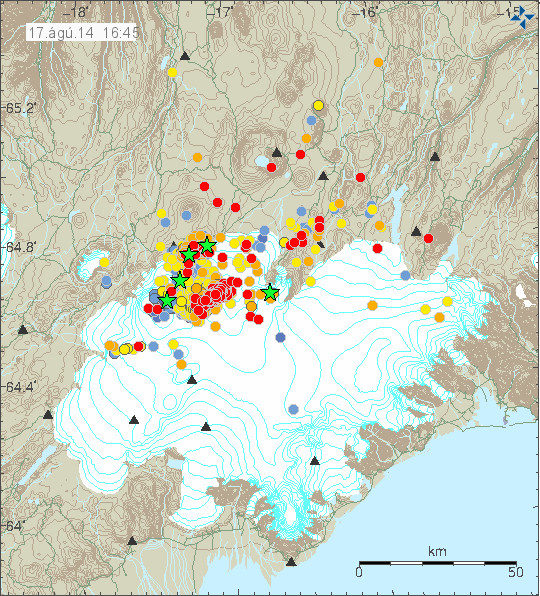
140816_1710_trace
As can be seen here the earthquake swarm is dense. Copyright of this image belongs to Icelandic Meteorological Office.

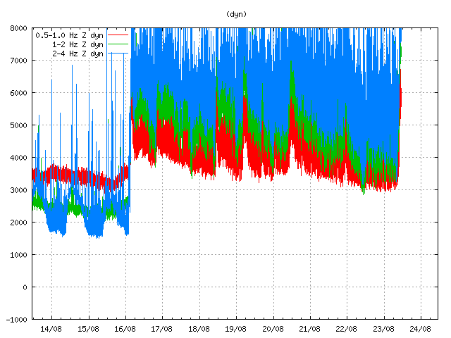
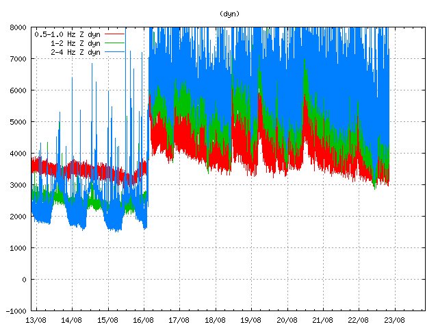
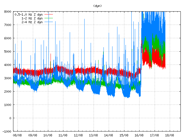
dyn.svd.16.08.2014.17.12.utc
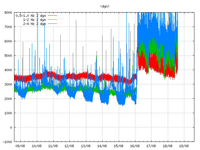
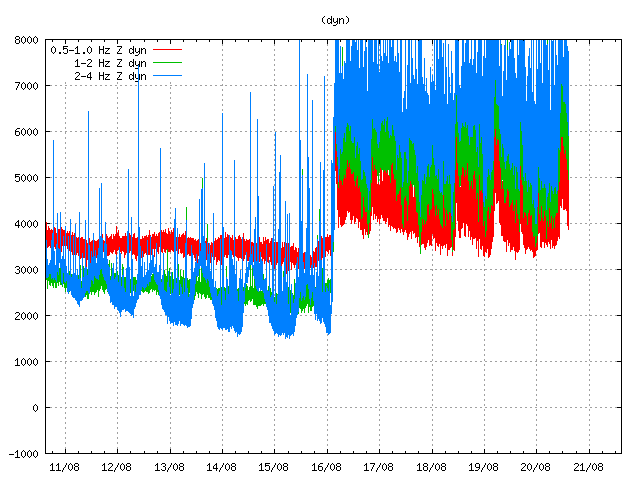
Harmonic tremor in Dyngjuháls SIL station. It has been dropping in the past few hours. Copyright of this image belongs to Icelandic Meteorological Office.

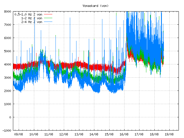
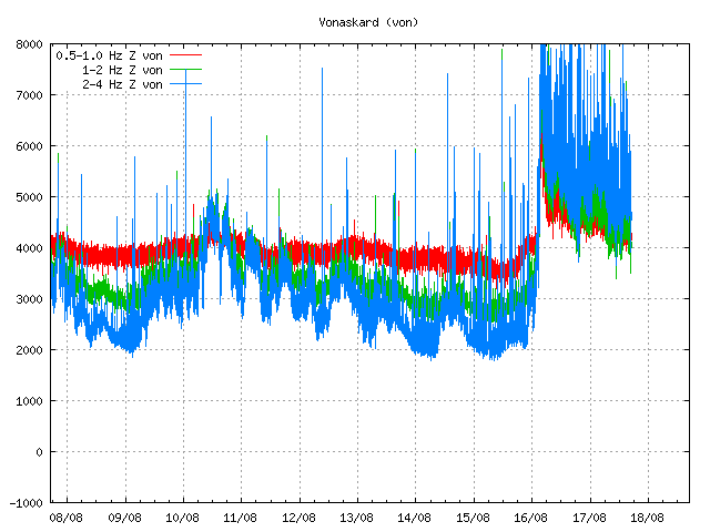
von.svd.16.08.2014.17.12.utc
Harmonic tremor in Vonarskarð SIL station. The drop in harmonic tremor also appears clearly here. Copyright of this image belongs to Icelandic Meteorological Office.

hus.svd.16.08.2014.17.13.utc
Harmonic tremor in Húsbóndi SIL station. The drop in harmonic tremor also appears here clearly. Copyright of this image belongs to Icelandic Meteorological Office.

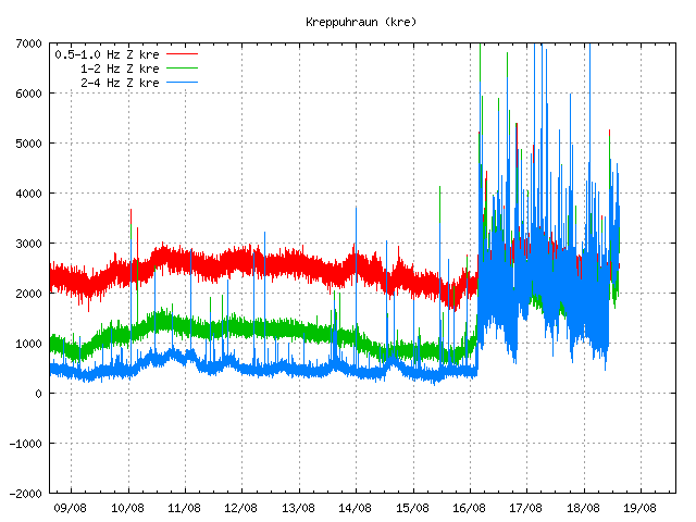
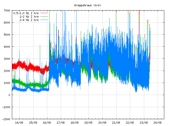
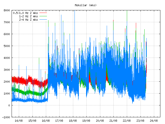
In the past few hours the harmonic tremors around Bárðarbunga volcano have been dropping slowly. The drop in harmonic tremor has not been followed by drop in earthquake activity. At least that is not the case when this is written. This means that the magma that is on the move there still has not yet found a pathway to the surface, even if some small part of it has done so in possibly in one or two eruptions vents under the thick glacier. If the harmonic tremor stops completely without the earthquake activity stopping it means that magma is still on the move there and it might look for a new pathway to the surface. When and where that might happen is impossible to know at current time, but once the magma has clear path to the surface, even if it is under a glacier all earthquake activity is going to stop (for most part).

I am going to post more information when more details are available.

Unconfirmed eruption in Bárðarbunga volcano

This information is going to get outdated quickly as more information is collected on this activity.

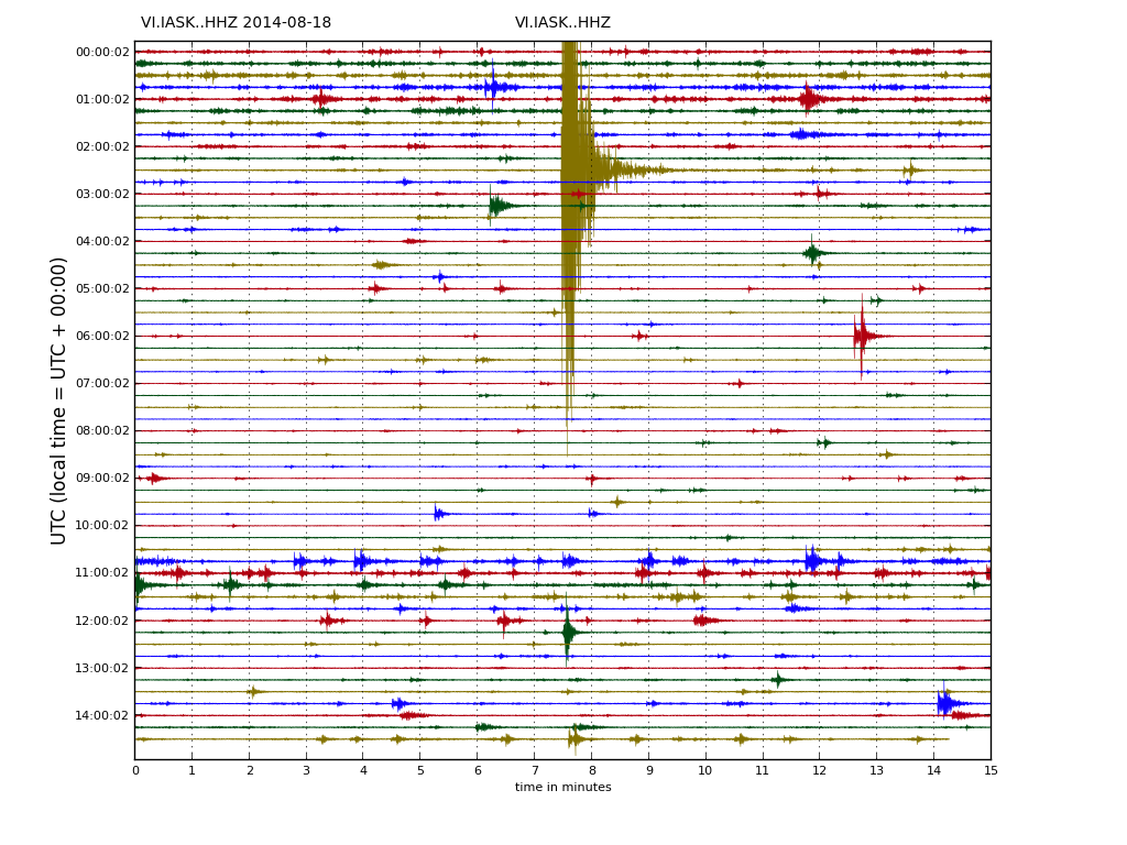
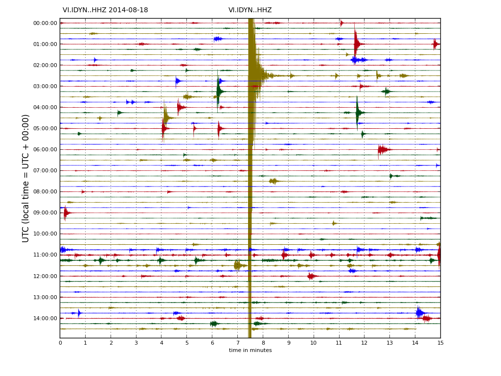
During all last week (Week 33) there has been a minor earthquake swarm in Bárðarbunga volcano. No other activity followed this minor earthquake activity during the week until last night (16-August-2014). During the night (around 02:20 UTC) a harmonic tremor started to appear on SIL stations around Bárðarbunga volcano. Following the appearance of the harmonic tremor earthquake activity started around 03:30 UTC. Largest earthquakes in this swarm have magnitude around 3,0 so far. Depth is around 5 to 10 km. During the night the earthquake swarm moved around in the volcano and is now more east then it first started. According to Rúv news the glacier around this part of Vatnajökull glacier is around 700 meters thick, so it going to take a major eruption to break the ice. This however also means that when a glacier flood starts in this area there is a high risk that is going to be large.

140816.040416.hkbz.psn
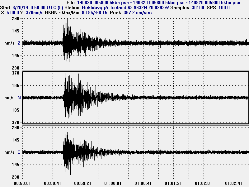
The largest earthquake that I did record during the night. This image is released under CC Licence. Please see CC Licence page for more details.

140816_1145
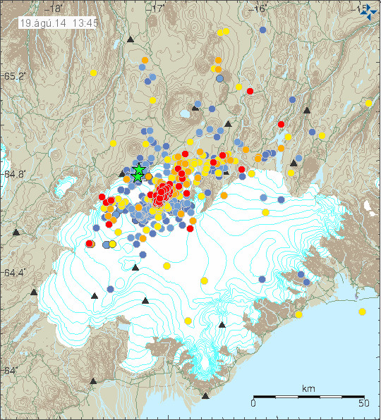
The earthquake swarm in Bárðarbunga volcano at 11:45 UTC. Copyright of this image belongs to Icelandic Meteorological Office.
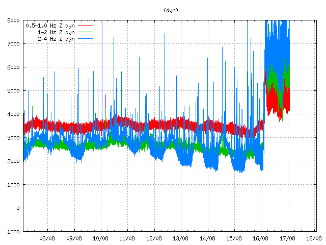
dyn.svd.16.08.2014.12.01.utc
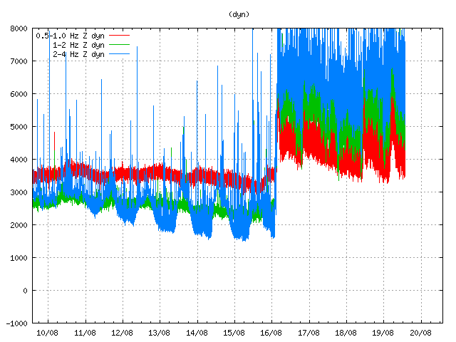
Harmonic tremor on Dyngjuháls SIL station. This SIL stations is closest to the area of activity in Bárðarbunga volcano. Copyright of this image belongs to Icelandic Meteorological Office.

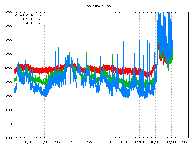
von.svd.16.08.2014.12.02.utc
Harmonic tremor on Vonaskarð SIL station. This is one of the SIL station that is closest to the area of activity in Bárðarbunga volcano. Copyright of this image belongs to Icelandic Meteorological Office.

Currently the activity in Bárðabunga volcano is not stable, it does fluctuate a little. Besides this minor fluctuation it seems stable. Based on harmonic tremor signal and its range this does not appear to be a large eruption so far. That might change without warning. I do however expect larger earthquakes before any major volcano eruption in Bárðarbunga volcano. What seems to have happened is that a dike intrusion got to the surface and started this eruption, even if it is just small one at current time.

I am going to post update soon as more information gets available. This situation is going to change quickly and without much warning.

Earthquake swarm in Hveravellir

Two days ago (13-August-2014) an minor earthquake swarm took place in Hvervellir (volcano). Largest earthquake in this swarm had the magnitude of 2,5. All the earthquakes that happened had depth less then of 10 km.

140814_2330
Earthquake swarm in Hveravellir (blue dots). Copyright of this image belongs to Icelandic Meteorological Office.

Earthquake activity is fairly common in this area. It however works in a short activity periods with long quiet period between them. So far nothing suggest that major earthquake activity is going to take place there, as has happened in the past. If that happens, the largest earthquakes can go up to magnitude 5,0.

Intra-plate earthquakes in north west Iceland

During the night of 12-August-2014 several intra-plate earthquake took place in north west Iceland. Largest earthquake in this swarm had the magnitude of 1,5. This earthquake activity did appear poorly on my geophone in Böðvarshólar. That is due to distance and small magnitude of the earthquakes, but my geophone at Böðvarshólar did detected this earthquake activity and from that I know that more earthquake activity took place than appears on Icelandic Meteorological Office maps.

140812_2130
The earthquakes in north west Iceland (yellow). This are intra-plate earthquakes. Copyright of this image belongs to Icelandic Meteorological Office.

This earthquake activity is not connected to any known fault zone or any known faults. That however does not mean they are not there. It is impossible to know if there is going to be more earthquake activity in this region. This is however second time this year a earthquake swarm takes place in this area, last one took place in week 28 (in Icelandic). That week the largest earthquake had the magnitude of 1,6.

Minor earthquake swarm in Krísuvík volcano

Yesterday (11-August-2014) a minor earthquake swarm took place in Krísuvík volcano. The largest earthquake in this minor earthquake swarm had the magnitude of 3,4 with the depth of 4,4 km. Only few minor earthquakes took place after the largest earthquake.

140811_2100
The earthquake swarm in Krísuvík volcano, the green star shows the location of the magnitude 3,4 earthquake. Copyright of this image belongs to Icelandic Meteorological Office.

There is a risk of more earthquake activity in this area. Since earthquake swarms are known to start with minor activity that slowly grows until it tops and then slowly drops over a period of days or weeks. It might not happen now, but this is a common pattern on the Reykjanes.

Minor earthquake swarm in Torfajökull volcano

Today (31-July-2014) a minor earthquake swarm took place in Torfajökull volcano. This was a minor earthquake swarm and no earthquake did go above magnitude 3,0. Strongest magnitude of this earthquake swarm had the magnitude of 2,3. Depth of this earthquake swarm was from 15,1 km to around 1,0 km.

140731_1820
The earthquake swarm in Torfajökull volcano. Copyright of this image belongs to Icelandic Meteorological Office.

This earthquake swarm appears to be over, at least at the moment. It might start again at later time. Earthquake activity is common in Torfajökull volcano and there are no signs of any other activity from Torfajökull volcano at the moment.

Earthquake swarm in Katla volcano

Few days ago the uncertainty level around glacier rivers that come from Mýrdalsjökull glacier have been cancelled. However the area remains dangerous due to gases that might collect in pockets in low lying areas. So it is not safe to go close to the glacier rivers from Mýrdalsjökull glacier even if the uncertainty level has been cancelled by the authorities.

140715_1525
Earthquake activity today in Katla volcano. Copyright of this image belongs to Icelandic Meteorological Office.

Today (15-July-2014) an earthquake swarm took place in Katla volcano. Largest earthquake in this swarm had the magnitude of 3,1. Other earthquake that happened where smaller. This earthquake swarm is one of the most dense in the past few weeks and it appears that earthquake activity is once again on the rise in Katla volcano. I am now expecting this earthquake activity to continue. I also think there is a high risk of small eruptions within the Katla volcano caldera. This eruptions would only last for few hours at the most and not even break trough the Mýrdalsjökull glacier. It has to be noted that scientist on duty at Icelandic Meteorology Office does not agree with my opinion. While there is a high risk of this (in my opinion) that this might happen, it does not mean it is going to do so. The best thing that can be done for now is to observe activity in Katla volcano.

If anything more happens. I am going to post update on it soon as possible. Any large earthquakes that happen in Katla volcano do appear clearly on my geophone at Heklubyggð and they can be viewed here. There is also a web camera of Katla / Eyjafjallajökull located here.

Uncertainty level declared at Katla volcano

Today (8-July-2014) a uncertainty level was declared at Katla volcano. This means that people should be aware of the activity that is now taking place in Katla volcano. The most dangerous areas at the moment are the glacier rivers that come from Katla volcano, due the extremely dangerous gases that are in the water coming from Mýrdalsjökull glacier. People should not stop at Múlakvísl glacier river and other glacier rivers that come from Mýrdalsjökull glacier due to this danger. It is also unclear if an larger glacier flood might take place, if it does it is going to happen with no warning at all. Tourist in the area also urged to have there mobile phones turned on in case emergency SMS needs to be sent to people in the area around Mýrdalsjökull glacier.

140708_2130
Earthquake activity in Katla volcano during the past 24 hours. Copyright of this image belongs to Icelandic Meteorological Office.

Currently [when I write this text] there is little earthquake activity in Katla volcano. That calm might not last, since earthquake activity has had the pattern of dropping off for few hours between peaks in activity. The largest earthquake during the past 24 hours had the magnitude of 3,0. Smaller earthquakes had the magnitude of 2,7 and lower magnitudes.

140708.091700.hkbz.psn
The magnitude 3,0 earthquake in Katla volcano this morning at 09:18 UTC. This image is released under Creative Commons licence. Please see CC Licence page for more details.
Earthquake activity has been in the same pattern as did happen in July-2011. So far no harmonic tremor has been detected. It is impossible to know if this is going to result in a eruption or not. The risk of an eruption is higher now then normal, but that does not mean that a eruption is going to take place. It is possible to see larger earthquakes from Katla volcano here on my webicorder website. It is possible to see Katla volcano here if it is not too cloudy.

Donations: Please remember to donate to support my work or buy from Amazon (select your Amazon store before you buy). I am getting awfully broke already (I am just on minimal income from Iceland and that is no good). Thanks for the support.

Update at 21:27 UTC on earthquake activity in Katla volcano

This is a short update on what is now taking place in Katla volcano. This information might go outdated quickly after it is being written.

Currently the earthquake activity in Katla volcano is increasing. However there are no signs of imminent eruption as is. However that might change without notice under my current estimate. It is impossible to know if this activity in Katla volcano is going to continue to increase or slow down again. It is my estimate that activity in Katla volcano is going to continue to increase (based on past experience) before it quiets down again. That might not result in a eruption, since this type of activity does not mean that an eruption is going to take place. This activity in Katla volcano has increased that risk at current time and until this earthquake activity stops or gets to lower levels, that risk is going to remain higher then normal. As things stand now there are no signs of that an eruption is going to take place in Katla volcano.

140707_2017
The earthquake activity in Katla volcano during the past 48 hours. Copyright of this image belongs to Icelandic Meteorological Office.

During the minor eruption in Katla volcano in July-2011 (I wrote about it here and here) a minor earthquake swarm like this was also detected in Katla volcano. Back then as now it did start about one month earlier before the minor eruption took place. That activity took place in different part of the caldera then the activity that is now taking place. Today the activity in Katla volcano is the area that might have erupted during the 1918 eruption in Katla volcano (I think).

140706.234343.hkbz.psn
The magnitude 3,0 earthquake in Katla volcano yesterday. This image is under Creative Commons licence. Please see CC Licence page for more details.

This earthquake clearly shows the sign of magma under pressure creating a earthquake. This is a possibly a tornillo event. Since it is a low frequency, monochromatic and with long tale in it’s end. I don’t know what is going to happen next in Katla volcano, if anything happens at all other then just this earthquake activity. More water has been reported in Múlakvísl along with higher conductivity taking place, that however might just be rain water in the area since it has been experiencing heavy rain for the past few days. I am going to continue to watch the activity in Katla volcano.

Donations: Please remember to donate to support my work. Thanks for the support.

Ongoing earthquake activity in Katla volcano

There is currently an ongoing earthquake activity in Katla volcano. So far this earthquake activity has been small in terms of magnitude, with the largest earthquake only having the magnitude of 2,7.

140703_2050
The earthquake activity in Katla volcano. Copyright of this image belongs to Icelandic Meteorological Office.

140703_2155
Updated image of the activity in Katla volcano. Copyright of this image belongs to Icelandic Meteorological Office.

The earthquakes that I have recorded so far are low period earthquake. Suggesting that they are being created due to magma or hydrothermal change inside the volcano. So far nothing suggests that an eruption is imminent. But I find this activity in Katla volcano suspicious and something that needs to watch, since I think this might be a risky situation and it might change on short notice.

Hekla volcano

A magnitude 2,3 earthquake with the depth of 9,9 km took place in Hekla volcano system on 02-July-2014 at 23:48:57 UTC. No other activity took place following this earthquake. It is not clear why this earthquake activity is taking place in Hekla volcano.

Donations:
Please remember to support my work by donations or by shopping on Amazon via the banners that I have here. I get 5% to 10% of each sale made on Amazon if it is trough my banners (what you buy does not matter). Thanks for the support.

Article updated at 22:05 UTC.