
Donations: Please remember to support my work by donating or by buying from Amazon. Please note that Amazon does not pay-per-click, they pay by sale. Each click on Amazon banner here is valid for 90 days. Thanks for the support.
This information are going to get outdated fast.
Please note that I have to split the coverage of Bárðarbunga volcano. The amount of information on what is happening is more then I can put into one post. This also allows me to post more detailed information on what this information means.
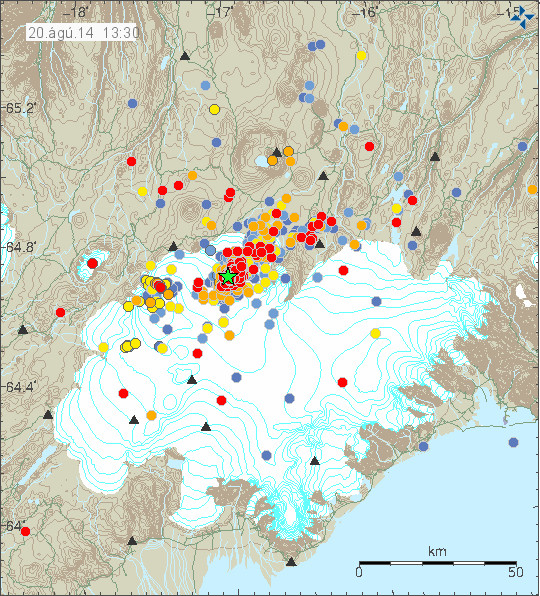
Earthquake activity in Bárðarbunga volcano for the past 48 hours. Copyright of this image belongs to Icelandic Met Office.
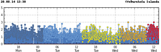
Earthquake activity did drop a little yesterday (19-August-2014). Today (20-August-2014) it increased again. What is also a interesting development is that earthquake activity has increased in Bárðarbunga volcano caldera. The caldera is filled with 700 meter thick ice so an eruption in it would be extremely bad. Largest earthquakes today (when this is written) have the magnitude of 3,0. Other earthquakes have been smaller. Over 500 earthquakes have been recorded since midnight (best number that I have).
Earthquake activity remains dense as it has been since the start of this activity on 16-August-2014. Copyright of this image belongs to Icelandic Met Office.
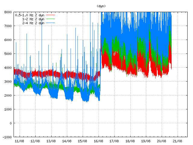
Harmonic tremor remains high as can be seen on Dyngjuháls SIL station. Copyright of this image belongs to Icelandic Met Office.
This high harmonic tremor means that magma continues to flow into Bárðarbunga volcano at same rate as before. There is a small fluctuation in the flow of magma into the volcano, other then this minor drop in harmonic tremor. Earthquake data shows that the magma is pushing north-east at slow rate. It is unclear how much magma the sill that is now forming can hold or how long it is going to fill up. I however see clues that magma is already looking for paths up to the surface.
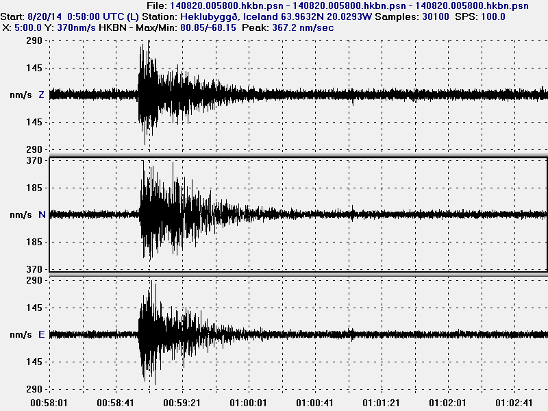
Long period earthquake that I did record today at 00:58 UTC. This image is released under Creative Commons licence. Please see CC Licence web site for more details.
This earthquake is a long period event. It is created when magma breaks into the crust and creates a pathway for it self. In doing so a gas is released under pressure, this also a creates earthquake and due to how this earthquake is created and due to influence of magma and gas the earthquake has long period signature. This means at some magma is breaking an path to the surface, if that magma is enough to start an eruption is not known at the moment. This magma is under high pressure, since the glacier on top of it is at least 600 meters thick.
Good synopsis. One that points to things getting hotter not cooler. Do you know what criteria might be used to raise the alert to Red? When the quakes are under 5km and migrating upward along with ground deformation? Could there be some pre-eruption flooding out the sides with gas and chemical evidence?
Remember the Gomer Pyle episodes on American TV. Gomer would tap the ground with his foot and would say, “its going to rain, its going to rain, rain rain”. I hear his echo now. Only now its ash.
When an eruption is about to start, they are going to change the colour code.
Where the all gas and steam go? There is 600 meters solid ice. If it goes surface, it would be a huge explosion? Am i right?
Great fan of your posts. For years now. You explain complex matters in a very simple way so we common folks can understand. Just observed a 3.2 earthquake in Bárðarbunga, 99% quality and around 3km deep. I suppose this supports your comments so far?
Just wanted to show this small film, which I am sure you have already seen. Interesting to see the 3d format.
http://www.mbl.is/frettir/innlent/2014/08/20/rividdarkort_af_bardarbungu/
Just for clarification, this 3D formatted film skews the depth of the earthquakes just to make it easier to see where the quakes are. The length of the base of the ground seen from above is 100 km x 70 km for the vs. the shallowest depth that is 500 meters to the deepest at 10 km.
This latest swarm seem to be somewhat shallower then the recent swarms. A sign of magma pushing up maybe??
Eric does the video suggest that the red dots being oldest?
Red dots are oldest, then orange, yellow, light-green and finally green dots represent the most recent earthquakes. A bit contradicting with vedur maps
A paper on Kistufell http://petrology.oxfordjournals.org/content/43/2/345.full states that this area is right on top of a mantle plume and has seen some of the hottest eruption temperatures (1240 ‘C) in Iceland. I would guess that such magma is rather fluid (ie. flows easily).
The authors also note “…P–T estimates suggest that the Kistufell magma last equilibrated at the base of the Icelandic crust and passed through the crust with minimum heat loss”. Would this suggest that once Kistufell magma started rising it erupted relatively fast?
Is this a special feature of the Kistufell area only or is it typical of Bárðarbunga in general, ie. is it typically erupting magma straight from the mantle or something which has resided in the crust for a longer time?
Just wondering why you think it’s going into a sill? I see no indication of this in vertical. It could be going into magma chambers or else hydraulically opening through-crust fissures (plenty of space) given the measured displacement.
As for why Grímsvötn is rising I’m guessing this could be a rotation or else minor compressive buckle due to extension in fissures. It’s that or its being pumped up again too. I’d like baseline distances between each station to see what’s moving relative to what more clearly with time. I read somewhere yesterday that more GPS sensors were being deployed around the active area. Maybe that data will be forthcoming soon.
PS: I’ve accidentally hot-linked two of your graphics elsewhere, I posted them only as links, plus gave your homepage as source but the blog software embedded them in-line as images anyway, my apologies – will not happen again.
This is getting exciting. I hope that the eruption does not hurt anyone, however I can barely contain my excitement that this volcano seems like it is about to erupt. Been a very long time since I saw a good fissure eruption!
Also, this is a really great 3D application to view the magnitude/depths in anywhere from 1-48 hours. Kudos to the developer who did this. http://baering.github.io/
I am on the North of Iceland now, and I am to find a safe place that I can wait a possible eruption. I am worred about the water flood generated by the activity and what direction that can go. Concidering your experience what suggestion can you give me?
Thanks
Please check with local tourist companies or authorities on safe locations if an eruption starts. I can not give an advice on this since I do not know this part of Iceland well in terms of good viewing areas.
Do you honestly believe it will erupt? Will the ice melt raise Atlantic Ocean levels?
buy a boat!!!
all the oceans are connected,,, And no it won’t raise the level..
If we are seeing any significant uplift in the zone under the glacier, I would expect to see surface cracks forming, even if the ice isn’t melting from any heat yet. Also, if there IS an active vent in the caldera area, the water might be dammed from getting out until it is of significant depth. I would be looking at ranging to the surface of the ice and see if we notice any changes in altitude.
The activity seems to drop back after larger earthquakes of groups in them, then slowly build again until the next big one. Perhaps the bigger ones release pressure which builds up between big ones.
Jon, do you still have a Paypal account?
Less earthquakes! Does that mean it is dying down or does that mean the magma has broken through?
Actually it looks like all the small earthqukes have been removed from the Icelandic Met office site, so probably nothing had happened and it is just that they are not all being displayed. Perhaps they will be put back when they have been revised.
Thought so, they have been put back now.
Moin from Bremen,
just made a small diagramm of the average depth of the quakes for the last 48 hours. quake depth is averaged over 1 hour.
http://www.image-share.com/ijpg-2667-38.html
I also marked interesting behaviour which seems at least to me to be repeating paterns of the process.
The overall average depth increase of 1 km / 48 hours seems not to indicate that a potential eruption could take place very soon. I belief its still a lot of process needed to take place until something happens.
Looks like the bigs one 3 or greater are getting nearer the surface though!
well the 1 hour average magnitude does not correlate with the 1 hour depth average, at least in the last 48 hours
http://www.image-share.com/ijpg-2667-134.html
Interesting !
I am sick today, so I don’t know what I can put up on the current situation in Bárðarbungua volcano. But I am going to do my best.
Just take it easy Jon. The IMO are keeping updates going and there are now webcams and more info coming on line. We will appreciate your analysis when you are able! Some interesting bigger eq’s and graphs to study too.
All the best mate.
Rest up, I think you’re going to need it I think we are about 2-4 weeks away.