Earthquake activity in Askja volcano

During the week there has been a swarm of minor earthquakes in Askja volcano. All of the earthquakes have been small and none have reached magnitude 2,0 far as I know.

150502_1850
Askja volcano is the volcano most south on this image (the volcano on the end). Copyright of this image belongs to Icelandic Met Office.

There is nothing suggesting that current earthquake swarms are due to magma movements at shallow depths. This is rather hydrothermal activity changes in the volcano due the it being warmed up by new magma entering it and warming up groundwater inside the volcano. That has happened before in earlier eruptions and is documented, the time scale of such changes is not documented far as I know.

Askja volcano started for prepare for an eruption phase in 2010, so far nothing suggest that an eruption is imminent, but it remains a question if the push from Bárðarbunga volcano has changed anything in Askja volcano.

Article updated at 18:56 UTC.

No lava flow visible in Holuhraun main crater

Today (27-February-2015) there was no visible lava flow from the main crater in Holuhraun. The eruption is not officially over, this however seems to be the end of this eruption in Bárðarbunga volcano. It appears that gas emission continue from the crater and Holuhraun at the moment, it can be expected those are going to end in next few weeks to months.

New video of the crater in Holuhraun can be found here.

Ekki glóð í gígnum í Holuhrauni – Myndband (Rúv.is, video)

It is not known what happens next in Bárðarbunga volcano or when it is going to happen. All that can be done is to wait and see.

Bárðarbunga volcano weekly update for 25-February-2015

There hasn’t been a lot of new information about the eruption in Holuhraun this week. Earthquake activity continues in Bárðarbunga volcano as before, but at slower rate and earthquake with magnitude 3,0 and larger have almost stopped at the moment.

150225_1415
Earthquake activity in Bárðarbunga volcano for the past 48 hours, no earthquake above magnitude 3,0 has been recorded for the past few days. Copyright of this image belongs to Icelandic Met Office.

Earthquake activity continues in Bárðarbunga volcano, but at far lower level than just few weeks ago. Subsidence has slowed down considerably at the moment. It has not stopped. There are earthquakes along the dyke from Bárðarbunga volcano, suggesting that pressure might be increasing in it. That in it self might not lead to a new eruption.

The eruption in Holuhraun continues, but at low level. The only remaining vent that is now open is building a new crater inside the big crater that has now stopped erupting. The eruption might continue at this low level for many more months. Current status of the eruption is not known due to extremely bad weather in Iceland at the moment. The eruption is not over, it is however really small at the moment.

Due to bad weather I am expecting that my geophones might go offline due to loss of power or other connection problems that might happen due to this bad weather. Information about the storm can be found here. This is not a weather to travel outside. If you are in Iceland, stay where you are and don’t travel until the weather has passed over Iceland.

Donations: Please remember to support my work with donations or by shopping with Amazon (select your area). Thanks for the support.

Article updated at 16:35 UTC.

Bárðarbunga volcano update for 30-January-2015

Since last update nothing major has changed in Holuhraun. There have been some changes in Bárðarbunga volcano it self and I am going to cover that later in this article. The magma flow from the craters in Holuhraun remains high at the moment, with latest flow measurements saying that flow of lava is now 100m³/sec. There seems to be uncertain or maybe changes in the flow of lava out of the crater. The volume is now ~1,4 km³. The lava-field has been getting thicker over the past weeks and closest to the craters it is now around 40 meters thick. New estimate of when the eruption might end are now 4 to 15 months.

150130_2050
Earthquake activity in Bárðarbunga volcano for the last 48 hours. Copyright of this image belongs to Icelandic Met Office.

Earthquake activity remains high, but it continues to drop at steady rate between weeks. Earthquake activity now also drops between peaks in activity. I still don’t know if a small eruption took place in Bárðarbunga volcano. Nothing has yet been confirmed and it might remain unconfirmed for a long time. I am also seeing small spikes in the harmonic tremor data due to hydrothermal activity in Bárðarbunga volcano (far as I can tell).

If anything major happens I am going to post update about it soon as I can.

Donations: Please remember to donate to support my work or support my work by shopping through Amazon links that I have here. Thanks for the support.

Possible minor eruption in Bárðarbunga volcano caldera

It appears that at 21:22 UTC (on 29-January-2015) a possible minor eruption might have taken place somewhere along the Bárðarbunga volcano caldera rim or in it slopes. I don’t have any confirmation yet, but this is what the tremor data suggest at the moment. This minor eruption appears to have lasted around 30 – 55 minutes in total. If there was an high amount of glacier melt the glacier water is going to start appearing in Jökulsá á fjöllum or other glacier rivers that come from Vatnajökull in next 8 – 18 hours. Depending on the router the water takes. I don’t know where it is going to go, but the highest chance is that it is going to appear in Jökulsá á fjöllum glacier river. This minor eruption was followed by a minor earthquake swarm, the largest earthquake in that swarm had the magnitude of ~4,5 according to automatic results.

150129_2350
The earthquake activity that followed this harmonic tremor (the red dots). Copyright of this image belongs to Icelandic Met Office.

dyn.svd.29.01.2015.at.23.55.utc
The harmonic tremor spike can be seen on Dynjuháls SIL station at the end of the blue line, where it spikes up. Copyright of this image belongs to Icelandic Met Office.

skr.svd.29.01.2015.at.23.45.utc
The harmonic tremor spike as it appears on the SIL station on Skrokkalda. The spike is clear based on other activity that appears clearly on this SIL station (earthquakes). Copyright of this image belongs to Icelandic Met Office.

dyn1_trem.svd.29.01.2015.at.23.58.utc High resolution image of the harmonic tremor on Dyngjuháls SIL station. This is the signature of eruption under the glacier. Even if it was just a small one. Copyright of this image belongs to Icelandic Met Office.

If anything more happens I am going to post update soon as possible. I am going to write about the earthquake swarm on the Reykjanes Ridge tomorrow.

Bárðarbunga volcano update Wednesday 12-November-2014

Eruption activity continued in Holuhraun at the same rate as on Monday (10-November-2014) and yesterday (Tuesday 11-November-2014). While bad weather has making observation of the eruption in Holuhraun difficult and close to impossible there are no signs of the eruption ending any time soon. A lava lake has now formed that is around 400 meters long and 100 meters wide. This is the first lava lake in Iceland in a long time. I don’t know when last lava lake existed in Iceland, but that was a while ago.

141112_2255
Earthquake activity in Bárðarbunga volcano for the last 48 hours. Copyright of this image belongs to Icelandic Met Office.

Earthquake activity in Bárðarbunga volcano continues as it has been doing for the past two and half months. This means that the caldera continues to subside at unchanged rate. I do not know how much the area has grown that is now subsiding, I think there is limited information on that due to limited access to this area in the winter time. At the moment nothing seems to be changing and GPS data is supporting that view of mine. Comments on this blog and blogs posts by people how have gone to the eruption site in recent days say that new fractures are appearing south of current eruption crater. This means that rifting is continuing, this also means that new eruption south of current crater might start at any time without warning. Since magma is at shallow depth at this location, with depth being only 1 – 2 km at most, it is possible that it might even be at shallower depth closest to the eruption crater (but has not erupted yet).

Tungafellsjökull volcano

There has been minor increase in earthquake activity in Tungafellsjökull volcano. At the moment this looks just like a tectonic stresses are adjusting to all the changes in Bárðarbunga volcano. Earthquake activity in Tungafellsjökull volcano might increase in next few days or weeks. I don’t expect any eruption to take place at this point in time.

Bad weather warning

For the next two days there is going to be bad weather in Iceland. This means that detection of earthquakes is going to be limited in Holuhraun and around Bárðarbunga volcano. This means that only largest of earthquakes are going to be properly detected. Visibility to the eruption site on web-cameras is not going to be awful to none due to the snowstorm that I expect might follow this storm in the highland (it might rain, but I am not sure on that detail yet). It is storm season in Iceland so expect a lot of storms all winter.

Bárðarbunga daily update on 29-September-2014

I am sorry for this late update. I did spend several hours trying to figure out a problem that does not appear to be on my end regarding my IPv6 tunnel connection. I hope this problem is solved by my tunnel provider (Hurricane Electric) soon. Now back to Bárðarbunga volcano.

Overview of the activity of 29-September-2014

  • Largest earthquake today had the magnitude of 5,5 and the depth of 5,6 km. Second largest earthquake had the magnitude of 4,9 and depth of 3,1 km. Other earthquakes where smaller. The largest earthquake was felt in Akureyri and surrounding area.
  • Due to bad weather it was close to impossible to make any observations about the eruption according to the news. Scientists where unable to go to there area today far as I know.
  • The eruption in Holuhraun continues as it has been doing for almost a month now.
  • 29-September-2014 means there is now one month since the first eruption in Holuhraun started and finished within few hours. The first eruption started and ended on 29-August-2014 and it erupted in craters that had last erupted in the year 1797.
  • Due to bad weather fewer earthquakes where recorded. Only earthquakes that did go above the wind noise where seen on the SIL network and my geophones.
  • The lava-field in Holuhraun is now larger than 44 square kilometres in size.
  • Bárðarbunga caldera continues to drop at same rate since that process started on 16-August-2014.
  • Nothing else to report far as I know

Images of the eruption

Here are few images of the eruption. Due to copyright I only link to them from this website.

Gengu á rauðglóandi hrauni í tæpa viku (People walking on red glowing lava for a week) – Vísir.is (Icelandic)

Winter arrives at Holuhraun (Rúv.is)

There are many pictures of the eruption on University of Iceland Twitter feed.

Minor increase in conductivity in Múlakvísl glacier river from Mýrdalsjökull glacier (Katla volcano)

Over the past few days there has been a minor increase in conductivity in Múlakvísl glacier river that comes from Mýrdalsjökull glacier. This is the glacier that is on top of Katla volcano. There is no unusual earthquake activity taking place in Katla volcano at the moment.

140908_1345
There is little activity in Katla volcano today. Copyright of this image belongs to Icelandic Met Office.

The reason why conductivity is higher in Múlakvíl glacier river over the past few days is that there are cauldrons in the glacier. Those cauldrons are created by hydrothermal areas in Katla volcano caldera. They empty them self on regularly during the year. There is no risk of eruption in Katla volcano at the moment. Activity is well below normal background activity fro Katla volcano.

Eruption update at 21:29 UTC

This information is going to go outdated quickly.

This is the current information about the eruption in Bárðarbunga volcano.

Please note: Since I cannot go to the area that is erupting my self (it is closed and I also live in Denmark at the moment). I have to relay on what is being told in the news and released by Icelandic Met Office along with other data. This means that I spend most of the day collecting data and working out what is going on (my view in most cases). This means that in most cases I write post late in the day when daily observation is done.

Current status of the eruption in Bárðarbunga volcano

  • New fissure did open around 2 – 3 km south of the eruption fissure that started erupting 31-August-2014.
  • Comments on this website did notice the eruption around 04:00 UTC on 05-September-2014. At the same time there was an minor increase in harmonic tremor on SIL stations close to the eruption.
  • The new eruption fissure is around 1 – 2 km long. It might get longer as time passes.
  • The new eruption was first reported by the press around 06:00 – 08:00 on Rúv.
  • New cauldron has formed some 6 km in Dyngjujökull glacier. The  glacier in the that area is 300 to 350 meters thick. Last report was that this cauldron was getting deeper during the day.
  • Higher conductivity has been reported in Jökulsá á fjöllum glacier river. That is currently continuing on that last check I did on Icelandic Met Office website.
  • Smell of rotten eggs is now coming from Jökulsá á fjöllum. Normally there is no such smell of that glacier river.
  • Inflation in the dyke continues, not on the same speed as before, but it is ongoing.
  • The rift valley appears to continue expand were he is visible.
  • The air around the eruption site is toxic due to release of SO2, CO, CO2, fluorine gases and other dangerous gases.
  • The water vapour cloud goes up to 4,5 km according to latest measurements.
  • The SO2 goes the way of the wind direction at any given time.
  • The lava field has just 1 km to Jökulsá á fjöllum glacier river. Once the lava enters the river it might start to build a dam and the lava is going to explode and steam a lot in the process.
  • Largest earthquake since midnight was magnitude 5,3 that took place at 01:19 UTC. It took place in Bárðarbunga volcano caldera rim. As other large earthquakes since this events started.
  • Largest earthquake in the dyke area took place at 14:31 UTC and had the magnitude of 3,2. It was under the glacier were most earthquake activity is now taking place.
  • Volcano eruption with ash cloud is now expected to take place. When and exactly where it is going to take place is not known at current time. I don’t think it going to have effects on international flight. But the local effects might be big if wind is in the direction of populated areas of Iceland.
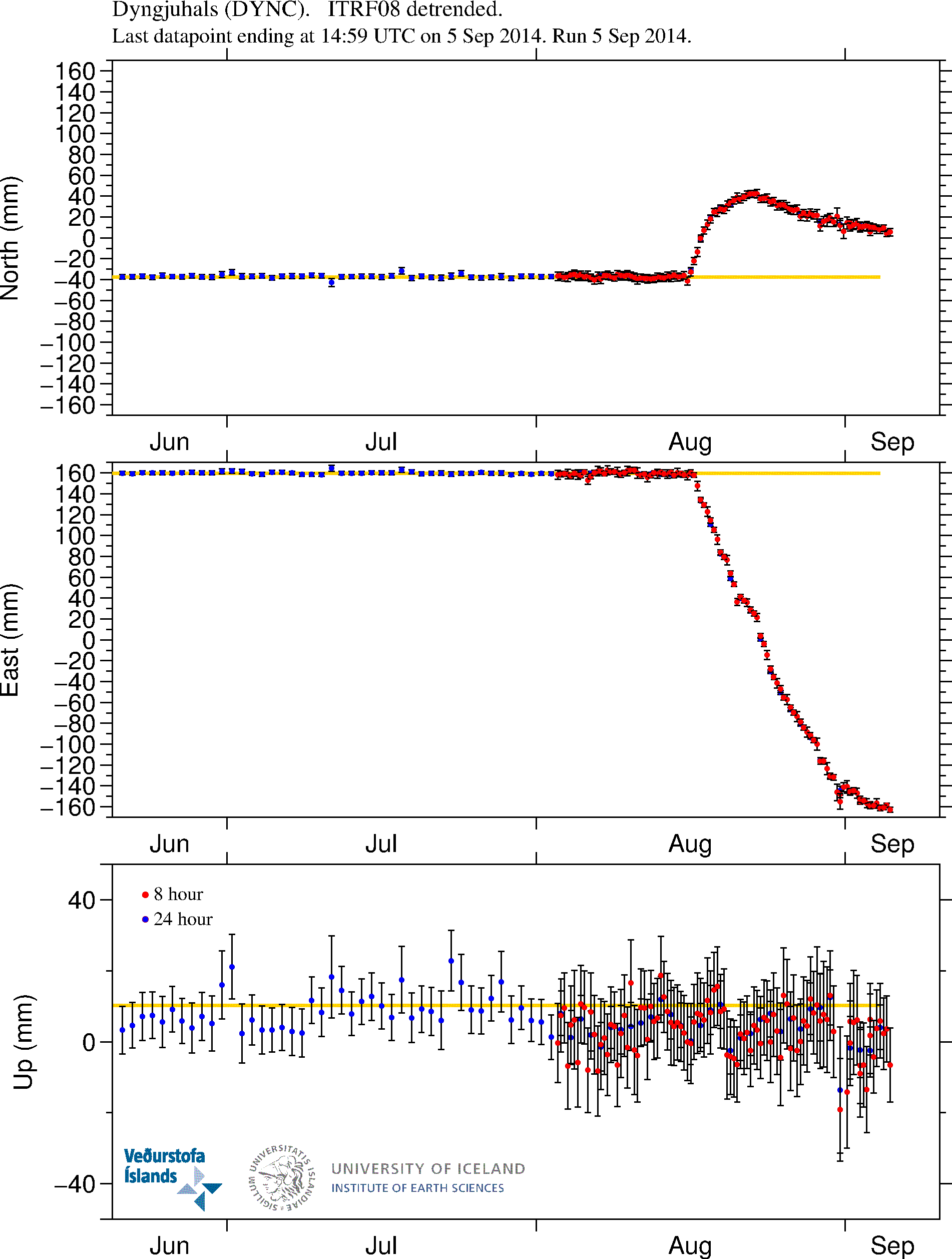
GPS inflation

DYNC_3mrap.svd.05.09.2014.at.20.56.utc
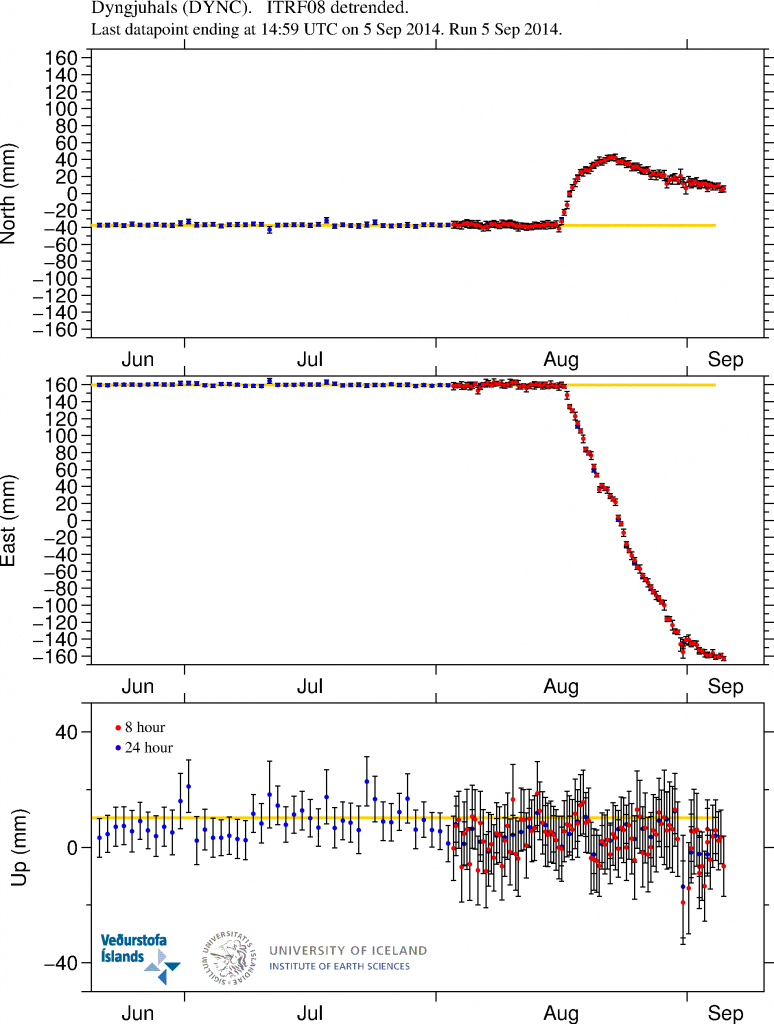
GPS measurements of the inflation that is currently taking place in the dyke. More GPS data can be found here. Copyright of this image belongs to University of Iceland.

Magma continues to flow into the dyke. It is at slower rates than before, but it still flowing into the dyke at rates that current eruption is not powerful enough to equal or drop the pressure inside the dyke. This is going to result in more eruptions as we have already started to see. When and where they are going to take place is something that is not known.

The eruption area is closed to the public

Due to risk of dangerous gases and flood the eruption area is closed to the public. Anyone that is found within the closed zone is going to get heavy fine. Going to this area is also extremely risky sine the area that is now eruption is extremely unstable with the risk of new eruption opening up without warning in the fault area and even outside it (if there is a weakness in the crust the magma is going to go that way). Police in Iceland have already spotted and fined two cars that were trying to enter the closed off area. This area of Iceland is also out in the middle of nowhere. The town is up to 10 hours away in a car (due to bad roads). Weather is also extremely unpredictable and can change without warning. So if you are thinking about going on car or foot. Don’t go!

The good news is that it is still allowed to fly over the area. So get one of those tours. I don’t know what they cost, but I know they take place if weather allows.

News bits

Arrested near the Holuhraun eruption (Rúv.is)
See the lava creeping forward at Holuhraun (Rúv.is, video)
The powers at play beneath the surface (Rúv.is, video)

More news in English can be found here (Rúv.is).

Updates for 06-September-2014

  • As noted by many here there is now news report on how much Bárðarbunga volcano has lowered since 16-August-2014. Bárðarbunga volcano has lowered some 15 meters according to latest measurements. This does not reduces the risk of eruption in Bárðarbunga caldera, in fact, this might increase it by a large margin. Such large drop in a mountain has not happened in Iceland since Askja 1875 when that volcano dropped some 300 meters in one of the largest eruption in the 19th century. According to the news on Rúv the caldera crust is in fact floating the magma that is keeping it up. Part of that magma is now erupting just north of Dyngjökull glacier.
  • Magnitude 5,0 earthquake took place in Bárðarbunga volcano at 05:40 UTC. It was in the NE Bárðarbunga in the caldera rim.
  • The risk of large eruption in Bárðarbunga volcano has increased due the current activity and drop of the caldera (as explained above). When such eruption would take place is impossible to know at this time.
  • The lava field is now just 900 meters from Jökulsá á Fjöllum glacier river. It is going to get into contact with the main stream sometimes in the next 24 hour period.
  • The activity in the new eruption fissure has decreased a little over the past 24 hours. It is now only erupting in one or two craters at the moment.
  • There is high risk of new fissures opening in the rift valley without warning. Both outside the glacier and below it. If an eruption takes place under the glacier there is going to be sudden glacier flood that is going to hit without warning.
  • Possible minor eruption might have happened under Dyngjökull glacier in last few days. As there have been cauldron formations in it. One of the cauldron is some 6 km from the glacier edge. The deepest cauldron is 35 meter deep according to radar measurements.
  • A new cauldron was also found some 10 km from the edge of Dyngjujökull glacier. This suggest that minor eruption took place there in past few days.
  • Blue mist has been seen today in east Iceland. It is not clear what is happening, but there are clues that this blue mist is connected to the eruption. Sensors to measure this blue mist have been sent to east Iceland. This blue mist can also be seen on satellites that Icelandic Met Office uses for weather measurements.

News bits for 06-September-2014

Rannsaka bláa móðu á Austurlandi (Rúv.is, picture of the blue mist, Icelandic)
Eldstöðvarnar í Holuhrauni – Myndband (Rúv.is, Icelandic, video)

Updates for 07-September-2014

  • Earthquake with the magnitude of 5,4 took place at 07:07 UTC. This earthquake took place in the caldera rim as other earthquakes in Bárðarbunga volcano.
  • The flow of magma is currently 100 to 200 m³ every second.
  • The new fissure has stopped erupting according to latest news.
  • There is a high risk of new fissure opening up in the erupting area without warning.
  • The lava field has reached Jökulsá á Fjöllum glacier river. This is going to increase conductivity in the river as the lava goes more into the glacier river. There is a lot of steam cloud being created following this. It is not clear when the lava field is going to dam the glacier river.
  • There are now only 2 – 3 craters erupting in the main erupting fissure. The power of the eruption remains the same.
  • Earthquake activity continues south of current eruption. Most of the earthquake activity now is taking place in the glacier, where minor eruptions have been taking place in past few days.
  • There is no sign of this activity is about to end.
  • Bárðarbunga volcano caldera continues to sink. There is a lack of earthquakes in the caldera it self. That suggest the heat below the crust is high enough to make the crust soft and that prevents earthquakes from happening. More on this tomorrow (Monday).

News bits on 07-September-2014

100 – 200 rúmmetrar úr jörðu á sekúndu (Rúv.is, video, Icelandic)
Svona hefur Bárðarbunga sigið (Rúv.is, picture of the lowering of Bárðarbunga caldera, Icelandic)

Article updated at 14:04 UTC on 06-September-2014.
Article updated at 14:11 UTC on 06-September-2014.
Article updated at 18:16 UTC on 06-September-2014.
Article updated at 18:18 UTC on 06-September-2014.
Article updated at 18:29 UTC on 06-September-2014.
Article updated at 19:43 UTC on 06-September-2014.
Article updated at 14:52 UTC on 07-September-2014.

Earthquake swarm in Katla volcano

Few days ago the uncertainty level around glacier rivers that come from Mýrdalsjökull glacier have been cancelled. However the area remains dangerous due to gases that might collect in pockets in low lying areas. So it is not safe to go close to the glacier rivers from Mýrdalsjökull glacier even if the uncertainty level has been cancelled by the authorities.

140715_1525
Earthquake activity today in Katla volcano. Copyright of this image belongs to Icelandic Meteorological Office.

Today (15-July-2014) an earthquake swarm took place in Katla volcano. Largest earthquake in this swarm had the magnitude of 3,1. Other earthquake that happened where smaller. This earthquake swarm is one of the most dense in the past few weeks and it appears that earthquake activity is once again on the rise in Katla volcano. I am now expecting this earthquake activity to continue. I also think there is a high risk of small eruptions within the Katla volcano caldera. This eruptions would only last for few hours at the most and not even break trough the Mýrdalsjökull glacier. It has to be noted that scientist on duty at Icelandic Meteorology Office does not agree with my opinion. While there is a high risk of this (in my opinion) that this might happen, it does not mean it is going to do so. The best thing that can be done for now is to observe activity in Katla volcano.

If anything more happens. I am going to post update on it soon as possible. Any large earthquakes that happen in Katla volcano do appear clearly on my geophone at Heklubyggð and they can be viewed here. There is also a web camera of Katla / Eyjafjallajökull located here.