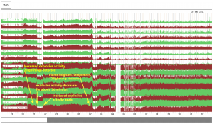
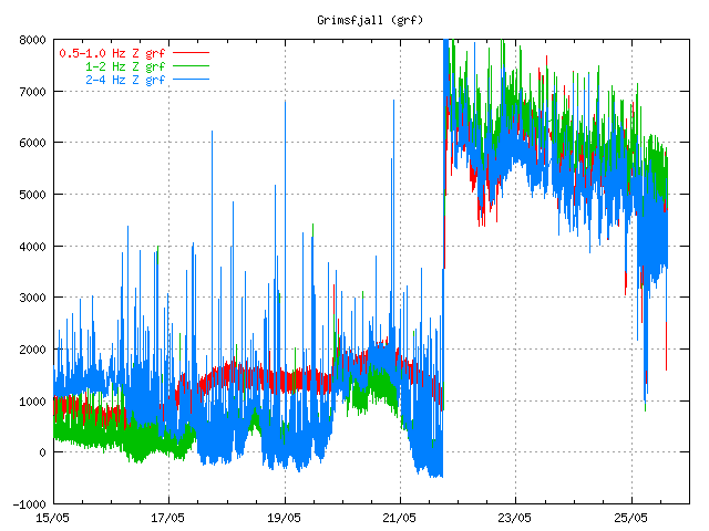
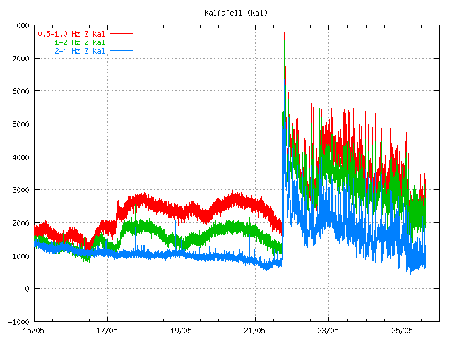
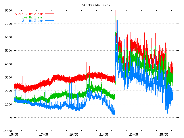
Here is a interesting paradox. While the eruption it self has currently stopped in Grímsfjall volcano. The tremor chart around Grímsfjall volcano is still acting like there is a eruption ongoing. I do not know why this is like this. But because of that I don’t think that geologist that monitor Grímsvötn eruption in Iceland are not ready to call off this eruption at current time. At least that is what the news did say at 12:20 UTC on Rúv.
They are also issuing warning to people not going to close to the volcano. As explosions due happen and they can throw up rocks that weight up to 1 ton. If anyone gets hit by that rock, that person does not have to worry about what happens next. The save distance for viewing the crater is estimated to be 2 km or more.
I have no idea what happens next. But I am guessing that this eruption might resume soon and without an any warning at all.
The tremor plot at 15:00 UTC. Pictures are from Icelandic Met Office.
This pattern of tremor is interesting. I am yet unsure what it means. But my guess is that this eruption is not over. Even if it has just stopped for now. I normally consider eruption over when the tremor has gone back into background noise (wind, ice, ocean etc..). That has not yet happened with Grímsfjall volcano eruption at this moment.
Update 1: Here is an tremor plot that Icelandic Met Office has released. The article where this picture is from Icelandic Met Office can be read here, it is in english.

Click on the picture for full size. I must point out that this picture is big. Copyright of this picture belongs to Icelandic Met Office.
Blog post updated at 20:46 UTC.


There are big fears that the melting from ash covered areas might be hazardous for locals.
http://www.ruv.is/frett/ottast-ad-vatnajokull-bradni-hradar
No dangers to the locals. But this means that Vatnajökull glacier is going to melt faster this summer then before due to the ash.
But the ash it self is going to create problems when it is blown with the wind out to the ocean.
If the layer is very thin, then yes – that would lower the albedo and hence melt the ice faster. It doesn’t require much tephra before the situation gets the other way around though – a few centimetres is enough to protect the ice beneath and lower the rate of melting. That’s the way dirt cones (or ash cones in Iceland) are made – by protecting the ice beneath the dirt (ash) as opposed to melting the surrounding ice. With that being said – I have no info on how much ash that has fallen in the different part of Vatnajökull. If one do have a tiny layer in the adjacent areas though – especially in ablation areas prone to melting during the season anyways – one should expect enhanced melting.
Well, it has been snowing, so perhaps the dark ash will soon be covered in a reflective white coating and make no difference.
The snow falling now will be ablated eventually during the summer anyways, but it may provide a buffer for the ash, hindering the wind blowing all of it away. It may provide some additional cohesion for the ash when it do melt, but I’m no expert on the grain properties of ash particles.
No mention of hazard to locals, it’s just expected that the glacier will melt faster which of course affects water levels in rivers.
The Grímsvötn / Grímsfjall volcano activity may connect with the sun’s activity.
Recently the sun has occurred in two C-class flares at UTC 20:00-21:00, May 25. The flare flux may arrive on the earth in 8-24 hours, and cause earth crust move, then further re-activate the Grímsvötn / Grímsfjall volcano activity.
The answer to that is no. It is always going to remain no.
Refreshingly brief and to the point, Jón.
😉 But there was a lady who used a New Dawn Tarot and predicted that a volcano would erupt “with fire and ice between Witches Night and All Hallows Eve”. Surely that’s proof of a connection! 😉
But when is witches night?
Witching Night is the night of April 30 to May 01, when all the witches fly to the Blockmountain . (This is the Broken in the Harz, Germany)
Now the tremor charts are acting like I have never seen it before (which actually doesnt mean much) but have a look below.
Can someone please explain why the width are so varying?
http://i54.tinypic.com/29zpgxz.jpg
What I mean is that the bands are so wide…Compared to when it was erupting violently.
That’s the amplitude I was talking about, perhaps a strange word in the context.
Wide bands mean teh amount of tremor is unstable and constantly changing. I have no idea what would cause that.
The Gfm tremor plot ( http://hraun.vedur.is/ja/vatnajokulsvoktun/grf_trem.html) shows remarkable similarities to the one from Eyjafjallajökull in 2010 if you take into account a rather compressed timescale. After the initial blast, there was a period of decline (G ~15h, E ~3½ days) after which tremor rose significantly again. This second phase of a slower rise and an even slower decline lasted ~60 h in G and ~14 d in E after which there was a break~, or rather, a period of low tremor (G ~13 h, E ~5~6 d). Then tremor rose again and in E there was a renewed eruption that slowly declined and dwindled away to nothing over a period of ~4~ 5 weeks. How long this phase lasts in G is anyone’s guess.
The differences are that the range as measured in output (ton/s) is far more extreme in the case of G (~10,000 to 0 tons) as opposed to E (~100 to ~5) and that after the second phase, G ceased to eject magma whereas E didn’t.
Is this a coincidence or is it an intrinsic property of Icelandic subglacial eruptions?
I believe the wide tremor bands could be explained by this “pulsating” bit.
Quote from IMO:-
“The activity is pulsating with explosions producing ash clouds that rise up from the craters, some reaching a few kilometers. The eruption plume is not continuous and all the material falls out nearby.”
The cams show dark skies and there still seems to be very much ash fall, especially at Grim’s cam. Is it possible that there was some more ash ejection at night?
What web camera are you watching ?
Grimsfjall sure likes to shroud it’s secrets in a veil of perpetual fog and rain. http://live.mila.is/grimsvotn2/ I haven’t seen a single frame where I can safely say I’ve seen the plume since the cam came online a few days ago. I guess that’s the kind of weather you would have on a glacier.
Too bad we haven’t got an IR camera like Vodafone had at Eyafjall last year.
Wind should be coming at a steady pace from the south though, which should make the camera be somewhere to the east of the caldera if you look at the direction the clouds are traveling. Which should make any potential venting from the volcano appear in the middle and towards the top left of the camera.
The IR-cam was also on the Mílawebpage. And this doesn’t help much when there is to much water (either vapor or rain) or dust on the air.
Yeah, that is a good point. There’s also a steady forecast of snowdrifts over Grimsvotn according to Norwegian Met. http://www.yr.no/place/Iceland/Suðurland/GrÃmsvötn/long.html
I guess the only way of getting better data would be to have a camera at Grimsfjall itself. Which is hardly an ideal location to be in at the moment…
Fixed url for forecast: http://www.yr.no/place/Iceland/Suðurland/Grímsvötn/long.html
http://en.vedur.is/about-imo/news/2011/nr/2188
Boris published this link on the Eruptions thread. Could it be that when the smaller vents opened the main force was dissipated? Would this then lead to subsequent ‘burps’ to follow, as per Renato’s question above, or will they all perhaps need to fill before a lava flow reaches the surface? Apologies if these questions just show my general ignorance.
What happens tremor wise if a large igneous intrusion like the formation of Dartmoor (UK) occurs? The plume which formed Dartmoor was after all, the same one as is now under Iceland.
Look at the formations . Are you sure its the same plume? The formations in devon/cornwall, and that of the Côte de granite rose In France and the Giants causeway in Ireland are all probably linked but http://upload.wikimedia.org/wikipedia/commons/a/ad/Europe_geological_map-en.jpg shows you more.
http://books.google.fr/books?id=-6gqvAbdS-MC&pg=PA266&lpg=PA266&dq=dartmoor+granite+source&source=bl&ots=cxvVQqTpVa&sig=PIFMSvKeDdjRg-lfHbREwg4LCb8&hl=en&ei=HkXeTaOeC9Sp8AO4grmVCg&sa=X&oi=book_result&ct=result&resnum=4&ved=0CCoQ6AEwAw#v=onepage&q=dartmoor%20granite%20source&f=false
Yes, but not recently. It was 300 million years ago and since then the plume has gradually drifted and so have the continents, so we have some of it’s giant pluton, but Iceland has the plume, not us any more. Your plumes are where Britain’s minerals and tin ore came from.
What I’ve read is that Icelands hypothetical plume was previously located beneath west Greenland and moved eastward. None of these theories has been proven and it’s even been discussed if Iceland is caused by a mantle plume.
See pdf article:-
a href=”http://www.celtlore.co.uk/dartmoorgranite.pdf”>Iceland Plume formed Dartmoor granite
Whoops! – trying to get the anchor right this time:-
Iceland Plume formed Dartmoor Granite
It’s not the best article on it as it covers the whole UK and not specifically Dartmoor, but it is the only one I can find quickly. I have read better though.
This article states that:
‘This suggests that an arm of plume material has extended, or is extending, from Iceland’
That’s something different than the idea of the plume drifting from the UK to the current location..
Just had a better look at that one. OK, I will try to find the article I originally read, but it looks like as you say, there are lots of clashing theories around and everyone is guessing anyway.
Your helicorder is more busy now…
Me think that is wind. 11 m/s at the mo. I might be wrong. give 30 mins and Hekla will go up. (:
It is the wind. It has been going up to 17m/sec.
How we can see the difference between wind and tremor signal?
It is not easy to see it on my sensors. But you can see the wind information for Heklubyggð geophone on my web site.
It is useful to figure out what type of noise is going on.
Dont forget flattr John! ( http://flattr.com )
Its famous in germany and growing rapidly im sure you will get something out of it,
its a good project that aims at the field of Many a little makes a mickle.
Just a small and very sad news,
that shows again that this world is on the wrong way
Italian seismologists to be tried for manslaughter – May 25, 2011
http://blogs.nature.com/news/2011/05/italian_seismologists_to_be_tr.html
Would be nice, if somebody could share it with Boris and get an hint of its true, and when it is to get some support for them.
Sad sad news, I heard its very political and because some “important people” was affected.
The sueing culture is out of control!!!!!!
Some things are just natural, not anyone’s fault.
Well… what do you expect the lawyers to do? Find and go after corrupt politicians?
My how bizarre that would be
How on earth would they have known the earthquake would happen, no one can predict when or where or how big or anything else about them.
damned if you do and damed if you dont. Now who do you think is going to want to be a seismologist in Italy anymore? You can quantify any risk and predict with even the slightest confidence level and yet your being told to predict and warn which if you do and nothing happens, you look like a fool and are discredited. If you don’t warn, you go to jail. Bastards.
spelling correction: “You CANT quantify”
My God, these are scientists – not clairvoyant !!!!!
If the school will soon make all seismologists and volcanologists are sitting in prison
A big Thank You to all of you for the quality info (but for the “2 VEI 6” mentioned a couple of days ago, that happened to be… 4000 yrs apart 😉
A trial makes sense if you read the second reply on “nature.com”:
the scientists will have to explain for whom they worked when asking the population to stay at home; this happened a century ago on the Island of Martinique, when the authorities wanted the population to stay because of the elections and the sugar cane was ripe… 30.000 dead.
In the area of l’Aquila, many followed the advice of the other scientists and slept in their cars, which saved their lives. Jehovah’s Witnesses, for example, instructed their members to do so following the declarations of Giampaolo Giuliani. Others must have done the same. A trial will tell if they were honest scientists or if they were manipulating the population for the politicians.
quote from http://blogs.nature.com/news/2011/05/italian_seismologists_to_be_tr.html:
“A lot of the story is missing here. There was another scientist, Giampaolo Giuliani, telling instead that a big earthquake was approaching.
People started to complain, and De Bernadinis, likely following Bertolaso and Berlusconi orders, simply picked a bunch of scientist with opposite prediction and told the population that no risk was present.
The phrase “the scientific community tells me there is no danger” is simply a lie. No scientist would ever said that. It would have been a lot different telling that no one could be sure of what would have happened. But the political order was to make population calm. ”
End of quote
The GPS data is interesting to say the least.
http://hraun.vedur.is/ja/gps/predorb/gfumpred.html
Can you explain please? I can’t understand it… 🙁
Excuse me jon, which site is this data coming from? is it normal to be like this after what has happen in the last week?
This the web site of Icelandic Met Office. This is uncorrected data, there might be errors in it. But I do not think that is the case now.
What it tells exactly?
It has been like that since the first day of the eruption. Has it been blown over in the wind? Gales are bad enough, but if the air is heavier, i.e. dense with thick ash and crash into it, can’t it or at least it’s aerial get blown over?
I guess part of a glacier could slump after an eruption too.
The GPS station is not blown over by the wind or by the ash. This appears to be how much the GPS station did move during the eruption.
GPS stations in Iceland so appear to be quite securely fixed to the ground : http://geo.arizona.edu/~sigrun/iceland/hvel/myndir/hvel3.jpg
If it has moved that far, how far away is the GPS station from the eruption site?
It is on the top of the volcano. Just few km away from the eruption site.
Is it broken?
No. It is not broken.
Has the measuring equipment fallen over? Was it 30 to 40cm high?
No. The equipment has not fallen over.
Heya, again thank you for all your hard work in here, it is much appreciated. You must be exhausted watching it day and night.
Can you please explain this GPS data for a layman. plain speak if you know what I mean.
Thanks 🙂
The GPS station just shows how much the Grímsfjall has deflated during this eruption. While this is preliminary data based on automatic process it is fairly accurate.
In this case it shows that Grímsfjall did drop 250mm (about) down during this eruption. But 250mm are about 25cm. Grímsfjall did move about 250mm north during this eruption. But that means that it did deflate in that direction. I do not know how far it did move west during this eruption. Because the plot did stop at 300mm west.
Here is a good USGS article on this subject, http://volcanoes.usgs.gov/activity/methods/deformation/gps/index.php
Thanks
🙂
So there may be some extra left in S or SE of Grimsfjäll…
The latest datapoint appears to show again slow ground inflation, but the displacement difference from the preceding one is probably within the measurement’s margin of error.
It will be interesting to see how this will develop in the forthcoming weeks or even days.
Excuse me Jon, what area is this data coming from? Is it normal to look like this after what happen last week?
I think it is normal if the equipment is trashed/burried in ash or whatever by the eruption.
If the equipment is buried in ash/ice, it would show false inflation, not deflation.
Please delete the post i log this under, it was a double posting. Thank you Jon. J
Just to keep things neat.
I am sorry. But I can’t do that now. It has been commented on already.
Thursday
26.05.2011 15:36:03 64.294 -17.157 7.4 km 1.3 32.13 13.5 km SSE of Grímsfjall
Thank you guys for the feedback and comments.
It was very dark when I posted my comment last night, and it was probably snow what I saw, but since it was darker than the other cams over Iceland, I took it for ashes.
But I can see how bad the weather is now. 🙂
New blog post is up!
Can somebody experienced in volcanology say anything about consequences of this eruption for amount of water in Grimsvotn caldera lake? Originating out of simple considerations, eruption has added a lot of heat to this under-ice lake, so a lot of ice supposed to get melted. Are there any fresh data about the level of water in caldera lake and about perspectives of new jokulhlaap anytime soon?
Or more likely we can just disinguish them again against the background noise now Grmvotn is quietening down
What is IMO doing with the Grimsvotn tremor plot? It was OK earlier, then a version was put up which ended on 25th May with nothing beyond. Their other vatnajokull plot also suddenly ended it 25th May too. Now they have put it back properly at the moment. It seems to be rising quite fast, but probably just the upward phase of it’s typical normal peaks and troughs – unless it keep climbing at that rate or course.