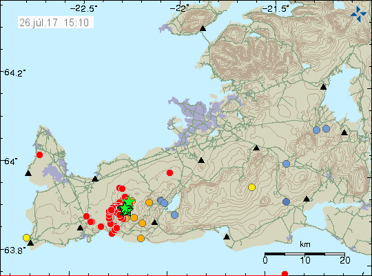
Currently there is a strong earthquake swarm on the Reykjanes peninsula. Largest earthquake so far was a magnitude 4,0 with second largest earthquake having magnitude of 3,8. This earthquake swarm is currently ongoing. Over 150 earthquakes have been detected so far (this number is going to get obsolete soon).

The earthquake swarm on Reykjanes peninsula at 15:10 UTC. Copyright of this image belongs to Icelandic Met Office.

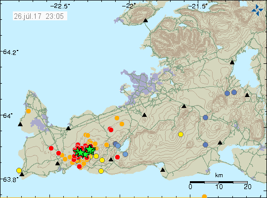
The earthquake swarm is highly active at the moment. Copyright of this image belongs to Icelandic Met Office.
According to the Icelandic Met Office (news at 12:20, Rúv) this earthquake swarm is a mixture of tectonic forces and magnetic (magma) forces in the ground. It is currently too early to know if this is going to result in a eruption.
Update 1 at 00:04 – 27-July-2017
Over 300 earthquakes have happened so far on the Reykjanes peninsula. Largest earthquake so far had the magnitude of 3,8 and second largest had the magnitude of 3,3.

Earthquake activity remains heavy on Reykjanes peninsula. Copyright of this image belongs to Icelandic Met Office.

Earthquake activity is heavy as is shown here. Copyright of this image belongs to Icelandic Met Office.
Earthquake activity is ongoing and strong when this is written.
This article is going to be updated as needed.
Donations
Please remember to support my work with donations. It helps me writing articles like this one about current event taking place in Iceland. Thanks for the support. 🙂
Article updated at 00:04 UTC on 27-July-2017.

If this is the beginning of the next eruption, it is a small surprise, even if we have seen some activity in this area lately.
Activity is slowing down a bit now, but is still loud…
It is a common feature in earthquake swarm like this that they drop in activity before it increases again. I don’t know if that happens now.
I am well aware of that. Interesting to see how authorities react as this is so close to populated areas. Especially Grindavík.
I do not understand. Are there any known active Calderas in this vicinity? Or maybe as you say, this is a genuine earthquake of tectonic ramifications. Iceland is an intriguing place.
The earthquake that this area is between two volcanoes. There doesn’t seems to be any volcano in this area according to my maps.
https://volcano.si.edu/volcano.cfm?vn=371020 (Reykjanes)
https://volcano.si.edu/volcano.cfm?vn=371030 (Krýsuvík)
Comment has been updated with correct information.
Might get interesting then.
Looks like some larger quakes coming through!
A Pleistocene Volcano:
Fagradalsfjall
250 quakes with 9 stars! I belive that when IMO review them the stars will grow…
One more star:
Wednesday
26.07.2017 21:40:55 63.877 -22.302 7.9 km 3.6 90.01 3.1 km SSW of Fagradalsfjall
Large earthquake appearing on my geophone now. Location is possibly in Katla volcano.
Wednesday
26.07.2017 22:15:30 63.660 -19.130 5.6 km 3.6 50.5 6.3 km ENE of Goðabunga. – but note quality; unreviewed as yet. Interesting place and depth if accurate; most stronger Katla quakes have been very shallow.
Katla!
http://www.volcanocafe.org/volcanic-unrest-in-iceland/
Updated:
Wednesday
26.07.2017 22:18:13 63.663 -19.084 0.1 km 4.5 99.0 8.6 km ENE of Goðabunga
Wednesday
26.07.2017 22:15:30 63.660 -19.130 5.6 km 4.4 50.5 6.3 km ENE of Goðabunga
wow what on earth is going on! the iceland met office EQ graph looks crazy
I bet that IMO has a tough time prioritizing and validating earthquakes right now. How many are working the night shift right now? More than usual…
Hi Jon. I just wondered if you or anyone noticed this one? It’s on the N-Atlantic page and happened at the same time as a few others nearer to Fagradalsfjall. Could they be related?
Wednesday
26.07.2017 21:40:04 64.031 -26.540 1.1 km 4.7 90.01 147.1 km WNW of Eldeyjarboði
Wednesday
26.07.2017 21:40:55 63.899 -22.293 6.0 km 3.3 99.0 1.0 km WSW of Fagradalsfjall
Wednesday
26.07.2017 21:40:32 63.899 -22.287 6.0 km 3.1 99.0 0.7 km WSW of Fagradalsfjall
Looks like IMO have now reviewed it and removed it.
It goes on. 438 quake in 48 hours.
Thursday
27.07.2017 14:31:35 63.903 -22.302 5.7 km 3.0 99.0 1.4 km W of Fagradalsfjall
Magnitude more than 3 in all: 13
Total: 466
This earthquake swarm continues. It has been at slower phase today. This activity might increase again. Largest earthquake in this area was a magnitude Mw6,0 in the year period 1960 – 1970. I don’t have the exact year of that at the moment.
Looks like the lava is trying to find a path, right now it is stuck 5km below.
Updating hourly:
http://hraun.vedur.is/ja/arg/png/reykjanes_15d.png
Interesting to look at the Reykjanes peninsula using this map: http://baering.github.io/earthquakes/visualization.html
Looks like two separate events.
This shows that there are two faults active in this swarm. Not a lot of magma on the move at the moment.
*facepalm*
http://www.independent.co.uk/travel/news-and-advice/iceland-volcano-eruption-biggest-ever-fagradalsfjall-reykjavik-a7865431.html
Typical “news”paper website misusing scientific quotes…