
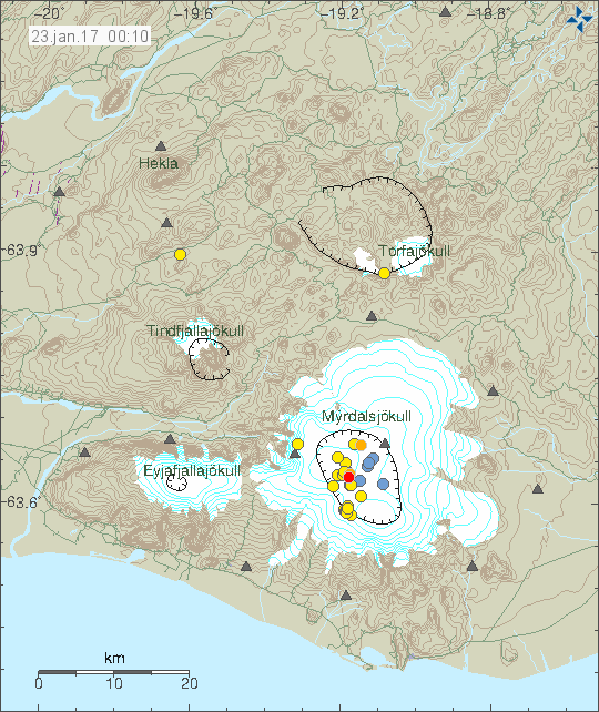
Since Saturday 21 of January 2017 there has been unusual earthquake activity taking place in Katla volcano (for this time of the year). Small earthquake swarms have been scattered all over the caldera, largest earthquakes so far have only reached magnitude of 2,4. Other earthquakes have been smaller in magnitude.
The earthquake activity in Katla volcano. Copyright of this image belongs to Icelandic Met Office.
This earthquake activity is unusual since normally Katla volcano is quiet in January and until June and often until mid-July when earthquake activity starts again. Current activity is unusual since snow has been adding on the glacier since it started snowing in Iceland this winter (November I think it was). Higher areas get snow sooner then lower areas, so it started earlier on Mýrdalsjökull glacier that is on top of Katla volcano. Currently the earthquake activity is ongoing, even if it has slowed down a little for the past few hours.
Donations
Please remember to support my work with donations. It helps me at current time with the money issue. Thanks for the support. 🙂
Wooouhhh,
Katla worries me a bit this morning…
http://hraun.vedur.is/ja/Katla/
Indeed another swarm this morning with largest magnitude M3.0
doesn’t the shallow depth of these earthquakes rule out magmatic causes?
Something is also triggering the shallow (likely hydrothermal) earthquakes, and I feel fairly sure magma has a fundamental role in the ongoing drama.
On Saturday and Sunday there seems to have been quite a few a bit deeper (between 2.6 and 7.8 km) earthquakes. To me it looks like things are moving upwards in that volcano. How deep the magma is, and how fast/to what direction it is moving inside the system, I wouldn’t dare guess.
It seems safe to say, though, that this bear isn’t sleeping very well this winter.
A tectonic green star from Bárðarbunga this morning (Source:IMO) Monday 23.01.2017 09:37:32 64.617 -17.412 5.4 km 3.9 99.0 6.1 km ESE of Bárðarbunga
Another EQ of significance in Katla caldera. And once again there is an absurdly strong reading from the ADA station. I don’t understand why this keeps happening.
http://hraun.vedur.is/ja/alert/2017/jan/23/028.html
One possibility could be that the signals showing up as ADA is somehow ‘wired’ together with AUS station somewhere along the way, because AUS is missing all together on that early warnings page. And the M3.3 in question should have looked ‘absurdly strong’ at AUS given the earthquake’s short distance to the measuring station.
I sent IMO a mail about it, so hopefully I can lay this question to rest soon.
Could the very high PGV be a result of the propagation of the earthquake’s movement through ice rather than rock? Does rock dampen the movement more than ice? I don’t know. And perhaps I’m thinking along completely the wrong lines. Anyone else?
I don’t know, the numbers would perhaps make perfect sense for Austmannsbunga, but Adalbol station is located far NNE of Vatnajökull. The easternmost station in the entire network, even. Any natural causes to this can be ruled out, I’m sure. There must be something buggy in among the signals.
Ah! I assumed it must be in the Katla area, near the maroon square. Must be an error; certainly can’t be anything to do with propagation media.
Monday 23.01.2017 18:14:56 63.660 -19.073 0.1 km 3.3 99.0 9.0 km N of Hábunga
I think it’s time we sat back and had a think about what may be happening here in Katla.
The explanation given for these very shallow quakes is generally ‘hydrothermal’. And yes – Katla does have a large and active hydrothermal system. I would however expect the quakes to be concentrated in particular parts of the caldera – coincident with the most active hydrothermal area. And there IS some concentration yes. But looking at the big picture there are some quakes in literally every part of the caldera; an area roughly 10km in diameter. And I don’t have a good explanation or even a likely model for that. Could there be very shallow hydrothermal quakes in literally every corner of the caldera?
Has there been any overflight of the caldera looking for cracking or cauldrons or changes in the ice surface?
Could it be that there is a truly massive hydrothermal system at fairly shallow depth and the hydrothermal ‘boiler’ is behaving a little like a swelling magma chamber and cracking the ‘lid’ over it?
Interesting questions that I have no answers to.
The only data I can find suggesting any swelling or ground deformation would be the Austmannsbunga and Enta GPS stations. Both of which appear to have shifted to the north(east) over the last 6-7 years, and I figure this should also to be expected if the magma chamber expanded, pressing the surrounding ground away from it.
https://notendur.hi.is/runa/eyja_gps.html
Data from overflights of the cauldrons can be found here:
http://jardvis.hi.is/myrdalsjokull_eftirlit_med_sigkotlum
Great link. Thanks!
This activity is clearly connected to magma. Its too big for any hydrothermal activity, few earthquakes might be due to hydrothermal or gas pressure changes, but this is way out of that range in terms of number of earthquakes and magnitude (mostly).
There is clearly something going on and a reason to worry I think.
If the shallow EQs are not hydrothermal in nature, then what is the possibility? Rock and ice literally cracking? All EQs show like short sharp shocks, and no harmonic tremor worth mentioning, right?
I’d also like to ask the same questions! it’s very interesting.
Ice doesn’t crack this way (the signature is different). Harmonic tremors won’t happen until after an eruption has started. At the moment this is just earthquake activity.
Okay, thank you, Jon!
Another M3 just now!