
Today (17-October-2016) and yesterday (16-October-2016) small earthquake swarms have happened in Katla volcano. Most of the earthquakes that happened where small, with magnitude 1,0 or less. Three earthquakes had magnitude above 2,0.
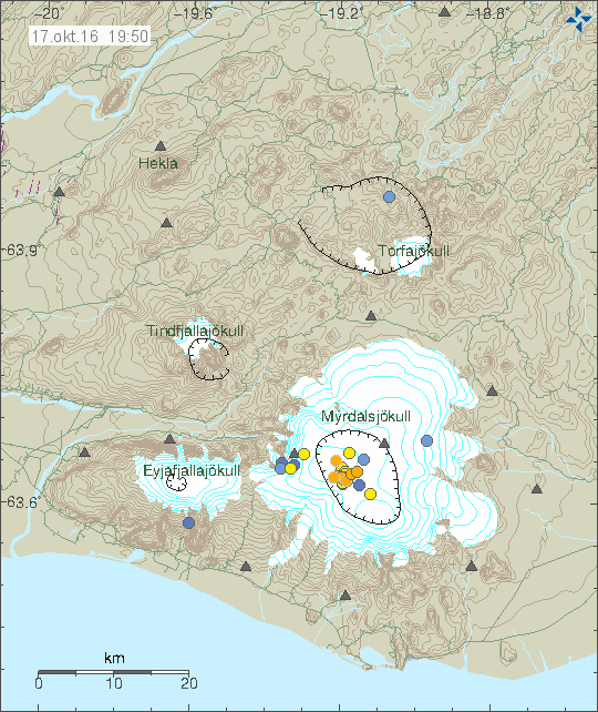
The earthquake activity in Katla volcano. Copyright of this image belongs to Icelandic Met Office.
In the news in Iceland today it was mentioned that this earthquake activity was due to heavy rain last week in south Iceland. I don’t agree with that assessment, since I recorded the strongest earthquakes and they show a clear sign of being volcano earthquake. I’m not able to record glacier quake activity at distance of 56 km (Heklubyggð geophone). The problem with volcano like Katla is the constant earthquake activity, over time there is a risk that geoscientists start to look at it as the normal pattern of the volcano and there is nothing to worry about. Current earthquake activity is of this nature and in my view its highly dangerous activity, while it has yet not resulted in a eruption there is nothing saying it is not going to do so soon. I remind people that is not possible to know when a eruption starts and it’s not known how an eruption in Katla volcano starts, besides what is know for historical recordings after the eruption has started (magma pushing towards the surface).
Conductivity is also up to 210µS in múlakvísl.
That is extremely high value for Múlakvísl during this time of the year and there is a lot of rain water in the river at the moment.
Conductivity is still rising. Over 220 as we speak.
Gauging station called ‘Múlakvísl, Léreftshöfuð; V414’ also shows significant rise in water level since 16:00 this afternoon. About 8 meters!? Why is this?
http://i.imgur.com/l3bdGqb.jpg
Sorry, my bad. that is CENTIMETERS, and is nothing out of the ordinary. I must be tired.
Here’s what it looks like with the time axis set to 2 months. Perhaps we can atleast see some significant changes in waterflow since late September.
http://i.imgur.com/8bvIv3t.jpg
Z, could you provide a link to the source of this conductivity/Múlavísl information please.
Kay Tina Cook:
Of course. It’s not possible to link directly to the specific Mulakvisl pages. You need to log in yourself using the provided login/pass on the right.
http://vmkerfi.vedur.is/vatn/index.html
You can also go here and click on the station and then select stations around Mýrdalsjökull. No login required.
http://en.vedur.is/#tab=vatnafar
But still, almost all earthquakes are only 100m down. That is not lava movement.
Jon, you said earlier that it might be gas expanding, which could make sense. Especially as conductivity in the rivers is high as well. But why would the gas come in clusters? Freed up due to rifting? But then why only in the caldera?
Something interesting is happening ere, we just don’t know what it is.
Rain making the glacier crack and fall is not likely either, the heavier earthquakes are a bit too large for that.
I’m not sure why this is, the data suggests this is connected to magma movements at more depth (no earthquakes). The rest has something to due with the volcano plumbing system and I’m even less sure how that works.
Article, https://www.sciencedaily.com/releases/2012/03/120330111023.htm
Three of the earthquakes listed for Oct 17 are 1.0 or 1.1 km depth. I assume the “Goðabunga” reference puts them in the Katla caldera.
https://www.volcanodiscovery.com/earthquakes/iceland.html
The notorious behaviour of Katla. About the types of eruptions (7), the view of a volcanologist who happens to be also a blogger (non peer reviewed but with listed sources):
https://davemcgarvie.wordpress.com/2012/11/06/katlas-next-eruption/
Interestingly under type 1 a comment is made that the probable 1955 and 2011 ‘events’ could also be geothermal based.
There are still no signs of caldera deformations or gas releases
https://www.wired.com/2016/09/earthquake-swarm-icelands-katla-raises-alert-status/
so this more than background noise could all also very well be the proverbial storm in a glass of water.
Thanks for the update Jon. Is this the same sequence of events which happened about 5years ago ?. Also small point is the number of quakes at depth in Askja ?.
It’s close, but larger at the moment and has been going on for longer time.
Another swarm this morning with max magnitude of 2.3 so far
Would you still visit iceland or is the risk to great heave the chance to go in 2 weeks. Sorry for the stupid question
I would always visit Iceland, no matter what.
A bigger risk is maybe a terrorist attack by IS!
They do seem to be everywhere lol
Go, my gosh if I had the chance I would be there in a heart beat!
*thumbsup*
😀
Hi, Could someone explain the mechanism behind river conductivity and what the significance is? thanks.
When minerals or gases come in contact with water will dissolve. As example , fresh water has little or no conductivity, but sea water has verry high !! In volcanic regions, the increse water conductivity occurs when gases (SO2 or CO2) will dissolve. And high level of those is a good sign of fresh magma inbound.
Looks like a couple of more heavy thumps, 2.3 and 2.9 less than an hour apart.
http://brunnur.vedur.is/gps/katla.html
Could someone explain what these graphs mean (North, East, Up, the numbers)? I remember someone saying AUST is the station to pay attention concerning Katla, so what does it mean when the “Up” graph is going up?
Negative is the other direction then what it says on the image. For instance, north is positive and south is negative.
Note: I think it works like this and I learned this after the 2010 eruption in Eyjafjallajökull volcano.
Thanks, that makes sense. So what kind of changes can we expect in gps graphs when/if an eruption is imminent? Is there gps data available of the Eyjafjallajökull eruption somewhere online?
After a sudden dip in conductivity, the levels jumped back up to over 220 uS/cm.
http://i.imgur.com/dw3nl26.jpg
I did speak to the Icelandic Met Office. They where cleaning the sensor today in the time period the conductivity was low.
Ok, great! That explains it. Did they have anything to say about the high conductivity levels in general?
They say that more hydrothermal water is getting into the glacier river. That is the only thing they know at the moment.
More rain is in the forecast later this week, as the remnants of Hurricane Nicole move in. In fact, another weather warning is in place.
When the Katla area was shut down recently, one of the concerns was the gases in the rivers and glacial meltwater. So if it is correct that the gases are causing earthquakes now, it seems to me that all this rain is indeed a problem. This is not a typical fall. The once-hurricanes have brought a lot more rain. Than normal. A lot! Extreme rain, gases moving, glacial melt, eruption?
If you look at the earthquakes, they have moved from East to West. What is this implying?
Opening of the plug? Rifting below the ice?
If my memory recalls, a large-ish 2+ quake at depth of over 30km depth happened about a month to 6 weeks ago. Do you think this had an impact on the overall situation
isn’t this odd? an earthquake swarm spread over the entire island….
https://s6.postimg.org/780u8vcs1/181016.jpg
Here’s the kind of thing I’m curious about WRT all the rain and melting in Iceland right now.
http://www.newsweek.com/nepal-earthquake-could-have-been-manmade-disaster-climate-change-brings-326017
Fall is Katla’s time. What will the heavy rains and melting bring?
The largest climate changes that the earth has had lately came from the removal of the ice-cap. That must have impacted much more than further global warming.
Typical alarmist article.
Is it just me or are we now seeing a slight trend towards deeper seismicity in Katla?
It seems to me that we’re seeing more quakes in the 1-3km depth range where previously they had almost all been in the 0-1km range…
Yeah Mike I was thinking that also
Mike, William,
this plot confirms you! http://hraun.vedur.is/ja/Katla/myr_allt.html
Scroll down to focal depth.
The newest quakes have been a little deeper than before.
There was one earthquake at depth of 15,8 km. That is not a good sign, as it suggests that magma pressure inside the system is getting close to a critical point (based on the earthquake activity so far).
Is there a connection between Hekla and Katla because there has been eathquake activity as well ?
*earthquake
Jon which part of Katla do you think will let go and what kind of magma will that vent produce? Sorry I know it’s maybe a million dollar question Jon
From what we’ve seen in the last few days I would say it will happen near the caldera centre, most likely it will be basalt with a small possibility of dacite or rhyolite.
It is not possible to know where the eruption is going to happen. It is going to be an basalt eruption, but explosive one due to the glacier.
Today there have been two deeper earthquakes of 1 magnitude, at 1.2 km and 3.6 km depth near Godabunga area. Any thoughts?
Study into Bárðarbunga volcano rift activity, http://www.nature.com/articles/ncomms12352
In hardware failure news, the UPS battery that I have on my Böðvarshólar geophone station has failed. It costs 95,08€ (11.950 ISK) to replace it. I don’t think I’ll be able to do so until December at the earliest.
Jon isn’t it funny how Katla seems to run in pulses with her activity
It’s not funny, she is just very impolitely laughing you in the face.
And the earthquake activity continues to go around the center of the Calder and have now come to the northern part of it (East to South to West to North).
Is the plug loose soon?
Actually, I have no clue regarding the last part, it just seems peculiar that it goes in a circular motion around the center…
I also woonder perhaps if the whole plug might not pop but perhaps a portion of it breaks loose what effect that would have ie would that reduce the size of any event ?
There is no plug in Katla volcano, rather a roof that leaks.
Image of the magma system as they think it looks like, https://en.wikipedia.org/wiki/Katla_(volcano)
Study (1993/1994), http://gji.oxfordjournals.org/content/119/1/277.abstract
I think katla’s taking the beeeeeep!
Small swarm on the Icelandic Reykjanes peninsula this afternoon I see.
So 4 more 2 + quakes since Sunday morning!
Jon there seems to be a lot of activity around Iceland over the weekend
This is just normal background activity. At the moment it is quiet in Iceland when it comes to earthquakes. Nothing interesting happening and it has been like this for days.
I’m using the time to attend to my other writing works and such things.
Came just home from a week long journey to Iceland. I’m very impressed about the fantastic landscape and nature. We stayed in different places where there were during our stay some earthquakes up to 3 magnitudes, but we never noticed any of them. When can you really feel them? (I’m really not disappointed but only curious…)
We also saw a short but impressive documentary film about the eruption of Eyjafjallajökull. At the visitor centre of a nearby farm we could also read about the lava, magma, stones and about the volcanic prosesses. All of that was very interesting for a non-geologist. I’d be interested to know if the Islandic volcanos have a very own geological nature, I mean is the lava much different from the lava types of other volcanos in the world or do they share about the same consistence?
That is quite a question. There isn’t one single type of lava in Iceland, because lots of things can happen before the below-ground molten rock (magma) erupts to the surface to become lava. For example, it can sit several miles below the surface, some rock components crystallize out and settle upwards or downwards, and the remaining liquid portion can then erupt. Or it can melt some of the walls of the chamber and become different as this source of rock is incorporated. The basic source of magma for Iceland is the mantle, and this magma does have a distinctive mix of elements if I am not mistaken.
I think it’s generally reckoned that earthquakes lower than magnitude three aren’t felt by human beings unless they are shallow and you are right on top of where they actually occurred.
Icelandic geology is fascinating. A couple of books I (a complete amateur) have found useful are Thordarson and Hoskuldsson’s Iceland book, and for more the more general geomorphological context, “Living Earth”: https://www.amazon.com/dp/178046021X/ref=pd_lpo_sbs_dp_ss_1?pf_rd_p=1944687702&pf_rd_s=lpo-top-stripe-1&pf_rd_t=201&pf_rd_i=1903544068&pf_rd_m=ATVPDKIKX0DER&pf_rd_r=10KY6WXP96NZCKMBTM8M
https://www.amazon.co.uk/Living-Earth-Outline-Geology-Iceland/dp/997933360X
The former is the better, clearer of the two but the latter complements it.
Thank you mudpot and Andrew!
Since nothing much is happening in Iceland at the moment, I thought that I would share this. It’s relevant in a way.
https://watchers.news/2016/10/23/earthquake-gakkel-ridge-volcano-north-pole-october-2016/
Thanks Gary I noticed the quake on the USGS site but could not find a way to tilt the map they use to actually see its true location.