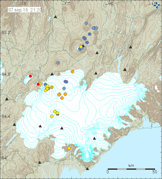
Yesterday (06-September-2016) and today (07-September-2016) deep earthquake activity happened in Bárðarbunga volcano system. Most depth was at 25,9km in Trölladyngja, it is one of several deep earthquakes that have happened in that area. Few earthquakes at depth of 20,8 km took place in Bárðarbunga volcano (outside of the caldera).

The deep earthquakes on this image are at south-east to Bárðarbunga (in the direction of Grímsvötn, north-east of Grímsvötn) and in Trölladyngja (one blue dot). Copyright of this image belongs to Icelandic Met Office.
In Iceland earthquakes at this depth only happens due to movement of magma. Crust stresses do have effects at this depth far as I know. At the moment no magnitude 3,0 earthquakes have happened in Bárðarbunga, that might be unusual since normally after a swarm of deep earthquake few strong earthquakes happens in Bárðarbunga. That has at time of writing of this article not happened. If that happens remains to be seen. I got the feeling there might be something more in the works, but I’m going to wait and see what is going on now. At least wait for a word from Iceland Met Office about what is going on, if anything is going on at all.
All that can be done now is to wait for what happens next. (This is what geology is mostly about, endless waiting for something to happen.)

Small flood in Skaftá river and EQs right now.
normal summer activity
Could be another green star for Bardarbunga. Let’s see what the manual check makes of it. I’m mostly curious about the depth and location. Right now it looks like the little swarm took place in Tungnafellsjökull.
Thursday
08.09.2016 08:41:30 64.776 -17.842 2.2 km 2.9 99.0 12.1 km ENE of Nýidalur
http://en.vedur.is/earthquakes-and-volcanism/earthquakes/vatnajokull/
On the IMO site:
During the last 24 hours, the level of the Skaftá river at Sveinstindur has risen significantly. This suggests that a glacial outburst flood (jökulhlaup) is in progress. It is likely that the flood originates from the western Skaftá ice cauldron, which last drained in June 2015; however this is unconfirmed until visual observations are made. The discharge of Skaftá at Sveinstindur is presently 270 cubic metres per second. The flood is not expected to cause any downstream disruption.
Written by a specialist at 08 Sep 11:12 GMT
What’s up with the tremor graph at slysaalda??
And I see a nice swam at tunga
Loss of connection.
http://hraun.vedur.is/ja/drumplot/drumplot/sly.png
I have no idea what I am looking at here with this link Jon – I’m sorry.
The white space between the coloured lines shows the drop in the connection to Icelandic Met Office of this SIL station. It is creating a fake tremor reading on the tremor plot.
Is this a weather issue with the equipment due to the storm? Good call on the prediction of the quake!!
Thursday
08.09.2016 22:09:13 64.645 -17.365 0.7 km 2.9 99.0 7.8 km E of Bárðarbunga
Tuesday
13.09.2016 08:15:40 64.662 -17.490 2.8 km 3.3 99.0 3.0 km NE of Bárðarbunga