
Today (19-August-2016) a magnitude 3,5 earthquake took place in Katla volcano. It was followed by several earthquakes, both before the strongest earthquakes and after it.
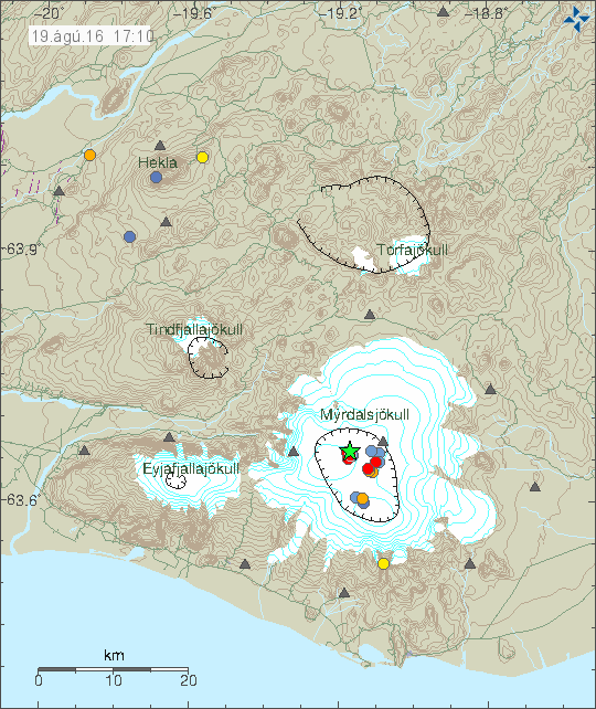
The earthquake activity in Katla volcano. The green star shows the location of the magnitude 3,5 earthquake. Copyright of this image belongs to Iceland Met Office.
This doesn’t seems to be an activity connected directly to magma movements. This might however be a gas under pressure breaking rock, since clues this summer suggests that heat is now increasing in the caldera. At least for now, it might cool down again in coming months. The most common months for Katla volcano to erupt are from July until November, eruptions in other months are less common, they do happen every few hundred years.
The magnitude 3,5 earthquake as it appeared on my geophone in Heklubyggð. This image is under Creative Commons licence. Please see the CC Licence page (above) for more details.
I really feel that Iceland will offer us some volcanic activity in the coming years because pressure does seem to be on the rise in a few of the Usual Suspect volcanoes and I watch a 45 minute video on Mr. Sigurdsson’s volcano museum last night and he mentioned that many Icelandic eruptions occur in unexpected locations. Activity inside Grimsfjall volcano is on the increase as well within the last 30 days or so.
I would be surprised if there isn’t at least one eruption before 2020, could easily be two. Grims, Bard, Hekla, Katla and let’s not forget Oraefajokull- I wonder which will go first! Is there a particularly high chance something could happen this year?
Not that it means anything special, just saying; M3.5 is the strongest EQ to occur within the Katla caldera since the start of this graph (January, 2011).
http://hraun.vedur.is/ja/Katla/katla_qu_rate.png
Great article.
Good to see you back Jon.
Some type of noise on the Grímsfjall SIL station. Not sure what it is. Might be melt water from the glacier.
The level of the Bláfjallakvísl glacial river is unusually high. Bláfjallakvísl originates from the northern side of Mýrdalsjökull glacier. Is there a chance that this was caused by Katla?
It is warm in Iceland at the moment. This means high melt from the glacier.
Sunday
28.08.2016 15:55:18 63.604 -19.105 0.1 km 2.5 99.0 2.7 km N of Hábunga
http://en.vedur.is/earthquakes-and-volcanism/earthquakes/myrdalsjokull/
4.5 overnight.