
Today (28-March-2015) there has been deep earthquake activity in Bárðarbunga volcano. This suggest that there is a fresh injection of magma into Bárðarbunga volcano system. If this is going to result in new eruption remains to be seen. It is not impossible at current time to happen. So far however nothing has happened. Deepest earthquake had depth of 21,1 km, others earthquakes are shallower.
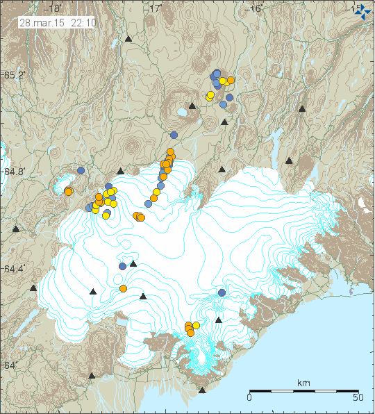
Earthquake activity in Vatnajökull glacier today. Copyright of this image belongs to Icelandic Met Office.
Öræfajökull volcano
Today (28-March-2015) there has also been deep earthquake activity in Öræfajökull volcano [Wikipedia link here]. This activity is not new and has been taking place every few months for the past 10 years or so. Quiet times are different in length. Each earthquake swarm that takes place is different in both magnitude and length, current activity appears to be deep, but mostly small earthquakes, less then magnitude 1,5 for most part. Deepest earthquake in this swarm had the depth of 25,0 km. This earthquake activity is only due to fresh magma entering Öræfajökull volcano system, not tectonic activity in this area due the depth of the earthquakes are taking place.
Based on historical accounts of earlier eruptions (1362 and 1728). It appears that eruptions in Öræfajökull start with powerful earthquake swarm (magnitude 4,0+ earthquakes). The following eruption is an ash cloud one with glacier floods taking place, with that phase lasting up to 48 hours. What happens after that is unclear, since it was not documented properly by historical records (at least not properly mentioned or lost due the old age of the historical records in question). Eruptions can last for up to 45 days, based on earlier documented eruptions. Current earthquake swarm is inside Öræfajökull volcano, since it is not round volcano, but goes a little to north where the earthquake swarm is taking place. There is no fissure swarm connected with Öræfajökull volcano, it does not rule out that one exist, it is at least not known at the moment. At the moment there are no clear sign that there is increased eruption risk from Öræfajökull volcano. That might change without warning, as is always the risk with volcanoes.
Donations: Please remember to donate to support my work or shop with the Amazon banners that I have here. If you don’t know you region, please check the site called “Amazon Webstore”. Thanks for the support.
Thank you Jon for the update. I looked at the map earlier today and saw red dots, yellow dots, and gold dots everywhere. It was a little unnerving, and peeked my curiosity. Others noted the upswing in activity and commented. I am wondering if the magma that is on the move is a warning of an eventual eruption, or if all will quiet down, keeping us in suspense.
Thank you for the update, Jón. 🙂
BTW: The coulour of the dots on IMO earthquake charts resp. maps tells us about the timespan that has passed since the event.
Red dots: within the last 6 hours, golden/orange: between the last 6 and 12 hours, yellow: between the last 12 and 24 hours; light blue: between 24 and 36 hours, dark blue: between 36 and 48 hours.
And what we see at the moment, is just normal activity in Iceland. It would be more weird when there were no quakes to be seen – except on some weekends when the IMO has reduced its staff during normal operation, and the checked quakes just appear later on Monday morning.
The geologist Agust Gudmundsson (Ágúst Guðmundsson) explains in some of his papers why eruptions in stratovolcanoes like Öræfajökull are much less probable than in volcanoes like Bárðarbunga which seems to have more of the properties of a shield. Stratovolcanoes – as indicated by the name – are built up from a lot of different layers of volcanic (ash, lava) and sometimes also sedimental rocks. For dykes, which are injected from magma chambers, it is much more difficult of propagate (ie. advance) through layers which have different mechanical (geologic) properties than through homogenous ones (ie. layers of the same consistence, which are more often found in shield volcanoes). So that intrusions like the one going on at the moment at Öræfajökull normally just get arrested (ie. stopped) somewhere. It is interesting to see the earthquake activity there, but the probability of an eruption in this volcano is really very low.
Sorry, I meant “to propagate” here.
Some more information on Öræfajökull and his 1362 eruption http://volcano.oregonstate.edu/oraefajokull and
http://folk.uio.no/rtronnes/Publ-sci/JVGR07-Selbekk-RhyoliteMagma-Or-1362AD.pdf
Thank you IngeB for the information on the latest quake swarm. I did some research on Oreafajokull, and did gather a little information. It is one big volcano! Here in the states we have many stratovolcanoes, and I have had the pleasure of visiting several in Oregon and Washington. They were very impressive, and fortunately they do not do their explosive thing often. However, these big boys do operate on time schedules, and it would seem that Oreafajokull has been resting for quite a while. Oreafajokull did not reach it’s huge size by not having repeated eruptions. My question is: What is this volcano’s schedule? Does it have a history of eruptions every 300-400 years, every 500-800 years, or is the interval between eruptions even longer? Has there been much research done on this volcano from perhistoric times?
Good question, Louise.
Stratovolcanoes on the west coast of the US are from the remelt of subsided tectonic plates under the edge of the continent. Hawaii is more similar to the circumstances in Iceland.
o/t
http://www.ldeo.columbia.edu/news-events/seafloor-volcano-pulses-may-alter-climate
Seafloor Volcano Pulses May Alter Climate:
“A new study shows that they flare up on strikingly regular cycles, ranging from two weeks to 100,000 years—and, that they erupt almost exclusively during the first six months of each year. The pulses—apparently tied to short- and long-term changes in earth’s orbit, and to sea levels–may help trigger natural climate swings.”
There’s nothing new about the myriad of complexities that affect earths climate, articles like this are interesting to read, but they always manage to slip in a what if scenario.
I’ll add my own what if, what if they took into account the billions of algae and microorganisms, phytoplankton, that break down co2 in the oceans. Then add that they produce more than half the earths oxygen supply and you have a different picture.
Earth is an extremely complex jigsaw of influences, each of which compensates for variables.
Is this weather related?
http://hraun.vedur.is/ja/drumplot/grf.png
I think we should perhaps see a green star once IMO has checked the data, in the vicinity of Hamarinn/Vonaskard/Husbondi stations. Around 5:50 this morning.
http://hraun.vedur.is/ja/drumplot/hus.png
http://hraun.vedur.is/ja/drumplot/ham.png
IMO has is as a 1,9
Monday 30.03.2015 05:49:22 64.491 -17.545 3.2 km 1.9 99.0 12.7 km E of Hamarinn
If it really is a 1,9 then most 4+ quakes during the eruption were false. Or the scaling is totally changed. I don’t think so, because I don’t seem to remember any 1,9’s lasting over a minute… And if you look at the quake at 00.44.04 rated at 1,1 it does not make sense at all.
Agree?
http://hraun.vedur.is/ja/drumplot/von.png
Well, I don’t agree
This is a shallow EQ, that triggered VON and HUS quite heavily, but only short.
The other two functional stations close to the EQ only show a light rumble.
Check out the rest of the stations further away and the EQ diminishes in the backround
http://hraun.vedur.is/ja/drumplot/
I thought about the possibility that the seismographs have been set to a higher sensitivity. Can’t think of any other option.
This 1.9 looks huge
Still doesn’t quite make sense to me Gwen. The dyn.plot is “frozen” on feb. the 5th and shows the drumplot with fairly the same amount of hours from midnight as the live von-plot does now. When reseaching the size of the quake showing in the drumplot from feb. 5th it seems to be a 4+. At BB.
See here: http://hraun.vedur.is/ja/Bardarb/bbbeginman24h/images.html
(if anyone has a searchable list over the quakes during the eruption it would be easy to search and compare)
This link gives (me at least) the drumplot of DYN at 2015-02-05:
http://hraun.vedur.is/ja/drumplot/dyn.png. Ofcourse the quake is at BB (von being closest) but still during the eruption the drumplots von/dyn didn’t show that much of a difference.
Feel I am very much still speculating here, but a 1 min. 20 sec.-ish quake like the one we see beeing a 1,9? I check the plots daily and nothing close to this has beeen observed in “after-erupton”-time ? And 2+ quakes obviously showing as smaller has been reported? Hmm. No big unanswered question that prevails me from sleep but still.
A scientific explaination would be very nice. 🙂 Simply because I can’t see the logic. 😉
I have to agree. The results shown were either wrong before or they are wrong now.
I agree with Atle. This is not the first time that IMO put 99 and revise later. And this is not first time when eq was wrongly estimated in after eruption period. Check this http://hraun.vedur.is/ja/alert/2015/mar/30/018.html
I’ve been puzzled by quite a few quakes since the eruption finished that have been recorded as being of a smaller magnitude than they looked relative to when the eruption was ongoing. This is the one that has most struck me as anomalous.
However, I too had wondered about recalibration by IMO, and have read on VC a post stating – how authoritatively I don’t know – that this is indeed the case. Here is the same page to which flaq linked, but for the big eq on 5th Feb that we’ve been discussing. http://hraun.vedur.is/ja/alert/2015/feb/05/012.html. I *think* that this points towards a recalibration: the figures in the mag column are much larger than for today’s “big” eq.
Maybe flaq can shed further light on the correct interpretation of these pages?
Ok, first of all I’m just observator like you guys. I might be wrong. During eruption it was enough for earthquake to pass one time line to be classified as mag 3.
We can estimate eqs by how many SIL stations felt it. I think that 1.9M eq wouldn’t trip 34 stations. If recalibration didn’t happend i would estimate that eq to be around 4M.
First parameter I look for is pgv peak ground velocity – the bigger the closer eq is probably, I dont trust dist parameter much it was wrong many times. Then I look for mag – it would be around 3.5M. I’ve noticed that automatic system tends to underestimate eqs, usually IMO estimate was bigger then automatic system. So for me it was under 4M eq.
And again thats just assumptions 🙂
Thanks, flaq, that’s helpful – at least I now know what PGV stands for! Armed with your surmises, and comparing the two charts, I’m now more confident that the drumplots have been re-calibrated.
And this morning a manually checked 2.6 that is barely visible in any of the stations close to the EQ.
I don’t understand it and it’s frustrating.
2.7 now. It was very deep, it was quite long, and it shows on a lot of the nearby seismographs, which seems to me to make sense.
Ah, I forgot to think about depth. Oops.
Thanks for pointing it out. 21.5 km, yes that’s very deep
think that was the earthquake 7.7 quake strikes off Papua New Guinea this morning
Interesting article about the area (off topic, Fragment of Jan Mayen Microcontinent discovered beneath Iceland points to ‘lost continents): http://www.ibtimes.co.uk/fragment-jan-mayen-microcontinent-discovered-beneath-iceland-points-lost-continents-1494187
They say that rocks at the Öræfajökull volcano are evolved, and that ~ ” there is a piece of continental crust there. This plume on the way up is tapping this crust and contaminating the lava.”
Grimsfjall tremor graph showing increased activity. Don’t think it is caused by weather conditions?
http://i.imgur.com/WVPzsnq.gif
This is something… low freq are rising too.
Now similar increased activity at Von. Seismograph picks it up as small spikes.
http://i.imgur.com/j2V3omr.png
http://i.imgur.com/2mB1y05.png
I wrote a post on my Spacewatch website. At the moment it’s more speculation then fact.
http://www.jonfr.com/spacewatch/?p=241
Jon there are also white holes,maybe this universum came from a white hole?=))
imri
It’s impossible to know of course, but the LHC could prove that we are still light years away from time traveling.
http://www.strangerdimensions.com/2014/12/22/cerns-large-hadron-collider-actually-star-gate/
At least CERNs research results in great usefull applied science:
http://home.web.cern.ch/about/updates/2015/04/cern-researchers-confirm-existence-force
I am finding it very difficult to make sense of the EQs when comparing the map / table to the drumplot. The times match up but the scale of EQs shown on the plot does seem strange.
URH, at a slightly greater distance, is more objective
See the discussion a bit higher up this page (iirc). And note the differences, if it’s possible now to get at the drumplots, between the readings for the very deep M2.7 that we were discussing, and today’s very shallow M1.5 at 12.23. The opinion seems to be that the IMO have recalibrated their seismographs.
A lot of information about the depth and location of eqs is contained on the drumplot traces, so we are now able to see more of that information displayed. I don’t know how to interpret the drumplots at all (I can’t tell the difference between P and S waves, for example), but/so I am prepared to believe what the IMO’s experts reckon.
SteveG, what is the URH?
URH is the geophysists’ abbreviated name for the seismometer at Urðarháls, which is more or less due south of the Holuhraun lava field and a bit west of Kverkfjöll.
Thank you, Andrew. The fog has now been lifted. 🙂
The von drumplot shows a fairly significant shake but I don’t see it on the IMO map
http://hraun.vedur.is/ja/drumplot/von.png
compare
http://hraun.vedur.is/ja/drumplot/von.png
http://hraun.vedur.is/ja/drumplot/urh.png
http://hraun.vedur.is/ja/drumplot/grf.png
These are progressively more distant from the big-looking earthquake
The drum record is exaggerated for nearby quakes
Thanks SteveG,
I see that the sensitivity has been adjusted to sense the smaller earthquakes.
Comparing the size of EQs and the drumplots on the Hekla pages and the Vatnajokull ones seems to me to be pretty conclusive in favour of the latter having been recalibrated.
http://hraun.vedur.is/ja/drumplot/hekla.html; http://en.vedur.is/earthquakes-and-volcanism/earthquakes/southerniceland/#view=table
http://hraun.vedur.is/ja/drumplot/vatnajokull.html; http://en.vedur.is/earthquakes-and-volcanism/earthquakes/vatnajokull/#view=table
Hi Jon. Is it me or has the activity picked up around Bards.