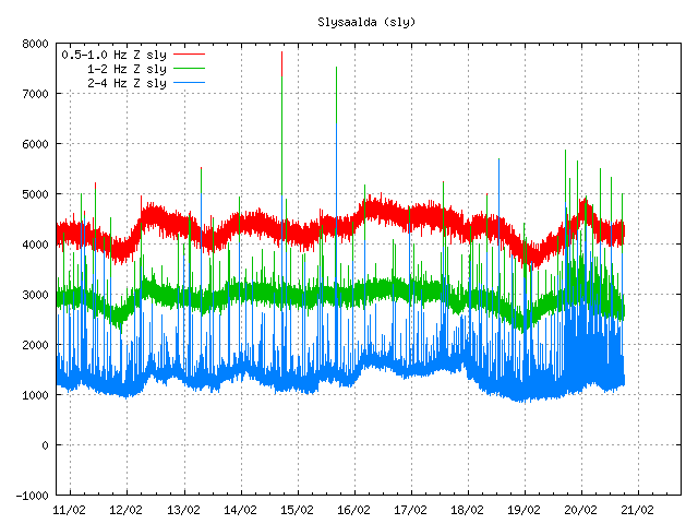
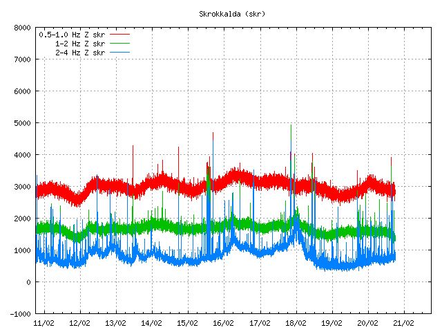
The harmonic tremor that started yesterday in Katla volcano continues. It is however at less strength then yesterday. Often there are small earthquakes following it. They can be poorly observed on my Heklubyggð geophone. Few earthquakes have happened during this unrest. GPS data is unreliable, as it has not been updates since mid December 2011 (why that is I do not know). At current time it seems that this harmonic tremor is dropping down at the moment. It is impossible to know for sure if this is the end of this tremor in Katla volcano for the moment or not.

The tremor noise as seen on Slysaalda SIL station. Copyright of this picture belongs to IMO.

The harmonic tremor noise as seen on Skrokkalda SIL station. Copyright of this picture belongs to IMO.
There are now two possible reasons why this is happening. This might be an increase in hydro-thermal activity in north part of Katla volcano. Second reason might be that this is magma moving around inside Katla volcano at depth, then out visible effects on the surface. That is earthquakes have not happened following this event to any extent. There have only been two registered earthquakes so far. There location is both poor and depth poorly located. It has been my experience that following smaller event of this type there is generally an earthquake swarm in Katla volcano caldera. The time is is from from this type of event to take place until the earthquake swarm takes place differs a lot.
Last minor eruption that took place in Katla volcano was on 6. September 2011. My blog posts about it can be found here. It was believed at the time this was water. But today I now think this was an small eruption rather then water flooding under Mýrdalsjökull glacier.
Strong harmonic tremor pulse starting in Katla volcano
Most likely water creating harmonic tremors in Katla volcano (for the moment)
Both blog posts are from 6. September 2011.

Interesting indeed.
How your geophone finds that some fragments of Helicoders minds earthquakes (marked in red) but others not?
Noise can also trigger red lines to appear on my geophones plot. It is normal and should not be confused with earthquakes. It is the strength and location of the earthquake that can trigger an red response on my geohones. Sometimes it does not happen at all, or just one of the other channels that are not published on the internet.
It’s Snaebyli I find particularly interesting, as well as Slyssalda:
http://hraun.vedur.is/ja/oroi/snb.gif
I notice it’s been quite lively in general recently, but this seems to be a more concerted effort. Just out of curiosity, isn’t this the closest to the beginning of Katla’s fissure swarms?
Thanks for the tech Jon.
Are there any profile monitors on Katla? I realise the glacial ice is an obstacle to measuring that, but I dont know if there is any kind of monitoring of it by other means?
Jon…erupção Hekla? http://eldgos.mila.is/hekla/
Tremors (or noise) from Jon’s heliocorders has increased. Building up a movie from webframe grabs. Still can’t say one way or other.
No. It is just increased wind in the area where my geophone is located.
http://www.volcanodiscovery.com/view_news/5564/Katla-volcano-Iceland-harmonic-tremor-could-indicate-a-small-eruption.html
Thanks for the link! 🙂
http://i42.tinypic.com/fp73w9.gif
Sorry for the delay. Technical difficulties
Moon is not a geologically dead place! Now they have found graden under the process of forming in Moon, see http://www.space.com/14632-moon-dead-geologic-activity-monitored.html
Helicorder Skeiðflöt (Katla) plot is allmost black. Continous tremor started? Activity can also be seen at Eyrarbakki plot, but not that strong.
This is just wind noise on both geophones. Nothing more.