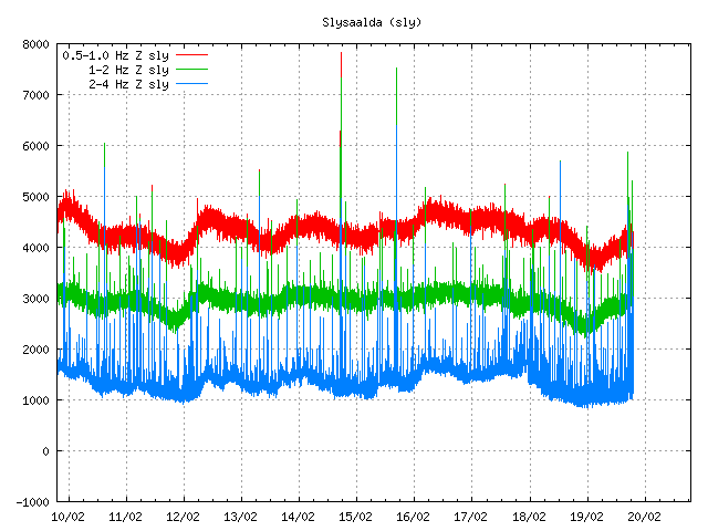
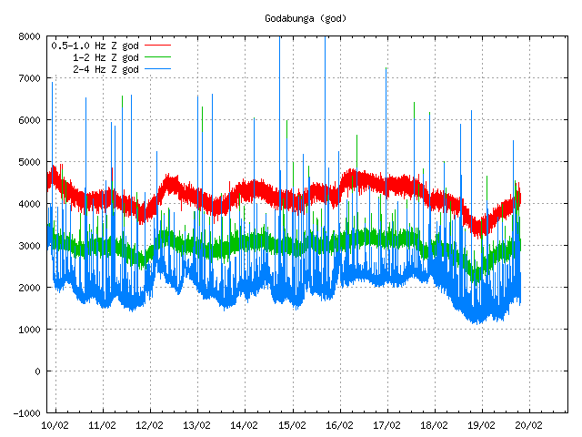
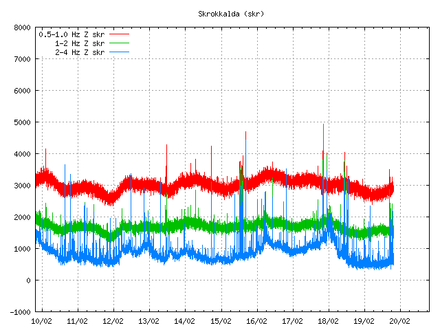
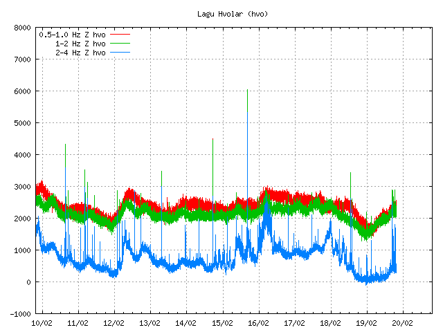
Today there was an harmonic tremor pulse in Katla volcano. I am not sure when this harmonic tremor pulse did start. But I am guessing around 15:22 UTC or maybe around 16:00 UTC. It seems that this harmonic tremor pulse was small, considering the activity in July 2011 in Katla volcano (an minor eruption). This harmonic tremor pulse seems to have happened in the north part of Katla volcano, outside the caldera from my best estimates but might well be inside it in the north part of it. But it hard to be sure on that detail. From what I can tell, this harmonic tremor pulse does not appear on my geophones clearly. But it might have appeared on Hekla geophone poorly. But it is hard to be sure on that due to wind noise. When this is written the harmonic tremor pulse appears to be dying down. But there is still an possibly that it might pick up again or an new one might start without warning. It is impossible to know for sure how long this is going to stop after this harmonic tremor pulse. This harmonic tremor pulse is due to dike intrusion in Katla volcano at depth, so earthquakes might not happen until it reaches shallower surface in the crust. If the dike intrusion gets that far to start with.

The possible location of the harmonic tremor marked by the poorly located earthquake in Katla volcano. Copyright of this image belongs to IMO (Iceland Met Office).

The harmonic tremor on the Slysaalda SIL station where it is the strongest. But that means it is closest to this SIL station. Copyright of this image belongs to IMO (Iceland Met Office).

The harmonic tremor pulse on Goðabunga SIL station. The harmonic tremor pulse is weaker here then on Slysaalda SIL station. Copyright of this image belongs to IMO (Iceland Met Office).

The harmonic tremor pulse on Skrokkalda SIL station. One of the SIL station that have the most distance from Katla volcano area where the tremor pulse is taking place. Copyright of this image belongs to IMO (Iceland Met Office).

The harmonic tremor pulse can clearly be seen on Lágu Hvolar SIL station. Copyright of this image belongs to IMO (Iceland Met Office).

The harmonic tremor on Smjörgil SIL station, it is located in the flanks of Eyjafjallajökull volcano. This SIL station is close to Goðabunga SIL station. Copyright of this image belongs to IMO (Iceland Met Office).
What happens next in Katla volcano is hard to know. It all comes down to wait and see what happens next in Katla volcano. Eruptions in Katla volcano in January – February time period are not common, but due happen at times. So this harmonic tremor pulse might be an advance warning of what is to come. But that is just speculation on my part. It is impossible to know for sure what happens in Katla volcano until it happens.

This might not be only Katla, but also something in the fissure systems…
The harmonic tremor is increasing again. So what ever this is, it is on the move and has not yet stopped.
I think this happens sooner, around 13:30 o’clock today. I can see the swarm on Mjóaskarð, Hekla (hraun.vedur.is/ja/hekla/oroi_mjo.html & hraun.vedur.is/ja/hekla/Stadsetning_stodva_31052011.jpg ) north of Katla (Slysaalda & Snæbýli hraun.vedur.is/ja/Katla/Myrdalsjokull.jpg) og GPS measurements on Austmannsbunga shows an interesting steady uplift. (hraun.vedur.is/ja/Katla/gps_austmannsbunga.html).
The quakes at Torfajökul were deep, ca. 8 km and that is another system of groundwater than at Tindfjallajökul area.
Yes, the earthquakes and tremor seem to be happening more to the north of Katla. I still have a small idea that this could also have been Torfajokull but it is a much less likely suspect. Yesterday there was also some signs of what look like tremor in SILs of Katla. So, I agree with you Jon, I think something is happening under Katla. We also had some poorly located earthquakes to its northwest today.
I think Katla now seems so close to eruption that an eruption in plain winter can happen. The rule that in summer ice melts and lifts pressure, but I think now lots of ice has already melt, so Katla can erupt at any time. However, I do expect first some deep earthquakes, so I still dont call for an eruption.
I know think that Torfajokull could be a likely suspect.
Torfajokull tremor would show up in north of Katla, southeast of Hekla, and in stations around Veidivotn. And would show probably easier in your Hekla geophone rather than the one south of Katla.
The last quake at 22:06 shows up clearly at Slysaalda and Mjóaskarð, less so at Godabunga and not at all at Gýgjarhólskot – suspect Torfajökull area
Sorry, but this gps measurement seems to End 2011?
hraun.vedur.is/ja/Katla/gps_austmannsbunga.html
Last minor eruption in Katla volcano took place on 6. September 2011 according to harmonic tremor plots that I saved from IMO that day. That event was small, in fact I only see on just handful of SIL station around Katla volcano.
Events like the one that is currently in progress have regularly taken place since July 2011. When an minor eruption took place in Katla volcano.
Could this perhaps be relieving the pressure in the volcano?
No. It is most likely increasing it. As new magma might be flowing into the volcano at depth. But it is hard to know that for sure at this point.
Looks like the harmonic tremor pulse is still going.
http://hraun.vedur.is/ja/oroi/sly.gif
This harmonic tremor continues. Second small earthquake took place close the location of the earlier one. But like before it is poorly located in both location and depth.
Hello, Jon. I just want to say that finally I am getting the real story on predicting the future Katla eruption — from you. For example, I learned that first there have to be some earthquakes deep below Katla, and then moving upwards closer to the surface. I would like to point out also that you use the word “but” a lot. I hope you don’t mind, your blog is good to read and does explain things about volcanic eruptions. Thanks, Wendy
Thanks for the tip on that language issue. This is due to my Icelandic language background. I will try to do better on this.
Is this noise on the god-station (http://hraun.vedur.is/ja/oroi/god.gif) or has the tremor increased?