This is a short update on Bárðarbunga volcano. Due to the fast change that is now taking place in Bárðarbunga volcano this information is going to get outdated quickly.
- Earthquake activity now is extremely dense. With 3 to 5 earthquakes taking place every second (best estimate that I have made).
- Earthquakes have increased in magnitude.
- General activity appears to have increased in Bárðarbunga volcano. Even if no major eruption has yet taken place.
- There is currently no signs of this activity stopping any time soon.
- The dyke in Bárðarbunga volcano continues to get longer and wider, it is now over 40 km long (I think). Formation of this dyke has slowed due to more difficult crust in the area he is now in (that means more earthquakes).
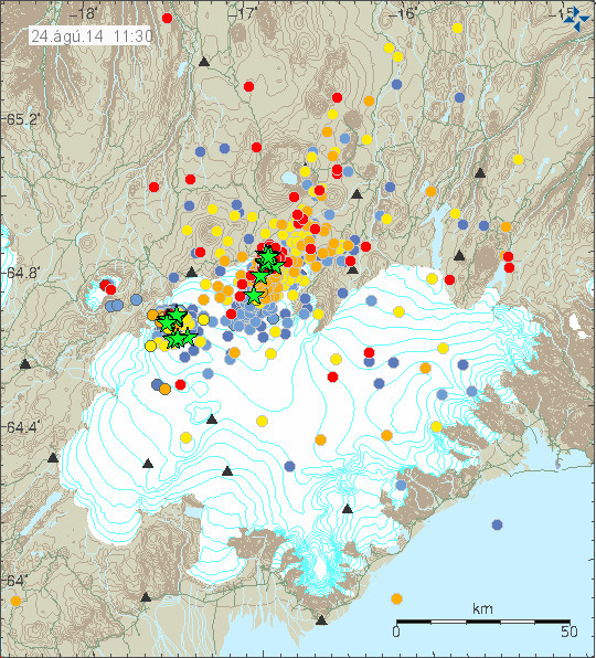
The current earthquake activity in Bárðarbunga. Copyright of this image belongs to Icelandic Met Office.

The extremely dense earthquake activity in Bárðarbunga volcano. Copyright of this image belongs to Icelandic Met Office.
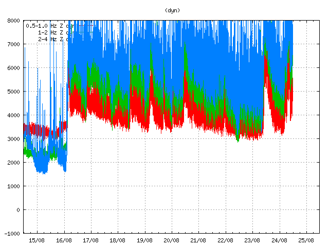
Harmonic tremor is getting off the tremor plot that Icelandic Met Office has on its website. This is the harmonic tremor at 11:33 UTC. This is Dyngjuháls SIL station. It is closest to the dyke at the moment. Copyright of this image belongs to Icelandic Met Office.
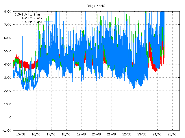
The SIL station in Askja volcano is also showing the massive activity in Bárðarbunga volcano. This is the harmonic tremor at 11:33 UTC. Copyright of this image belongs to Icelandic Met Office.
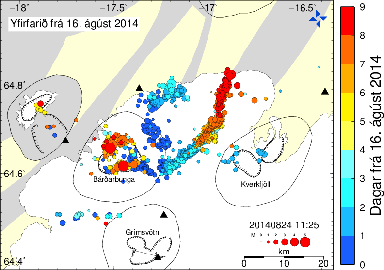
Current length of the dyke from Bárðarbunga volcano. Blue dots are the oldest and the red ones are the newest. This shows the earthquakes from 16-August-2014. Copyright of this image belongs to Icelandic Met Office.
The harmonic tremor seems to increase when there is a new flow of magma at depth into the dyke. Large earthquakes happens in Bárðarbunga caldera when it adjust to this flow out of the magma chamber above it. There are clues that magma at depth might have triggered this, but there is a lack of deep earthquakes in Bárðarbunga volcano so it is difficult to say for sure.
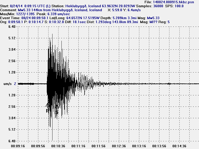
This is the magnitude 5,3 earthquake that took place today (24-August-2014) at 00:09 UTC. This is my geophone in Heklubyggð. This image is released under Creative Commons Licence. Please see CC Licence page for more details.
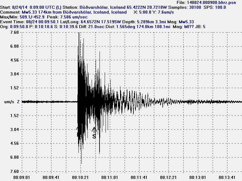
This is the magnitude 5,3 earthquake that took place today (24-August-2014) at 00:09 UTC. This is my geophone in Böðvarshólar. This image is released under Creative Commons Licence. Please see CC Licence page for more details.
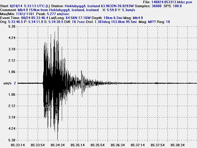
This is the magnitude 5,1 earthquake that took place today (24-August-2014) at 05:33 UTC. I use data from EMSC that explains different magnitude in the image. This is my geophone in Heklubyggð. This image is released under Creative Commons Licence. Please see CC Licence page for more details.
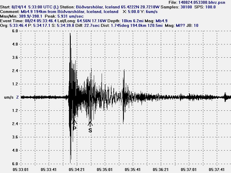
This is the magnitude 5,1 earthquake that took place today (24-August-2014) at 05:33 UTC. I use data from EMSC that explains different magnitude in the image. This is my geophone in Heklubyggð. This image is released under Creative Commons Licence. Please see CC Licence page for more details.
As explained above the earthquake activity is dense under Dyngjujökull at the moment. The dyke is also now in part on glacier free area, so if any minor eruptions happen they can be seen on the surface. The dyke seems to be under high pressure, but I don’t know yet if that is going to result in an eruption. But I find it highly likely at this point and given current data.
My geophones can be seen here. Some of the activity that is now taking place in Bárðarbunga appears on them. Larger earthquakes (magnitude 3,5 and above) appear always at this distance. Wind appears on my geophones if weather is bad in Iceland.
Updated at 14:12 UTC.

IMO confirms 30 km length of dyke
Excellent reporting Jón, good work 🙂
Thumbs up for your excellent reporting Jon.
(hope you are getting a decent amount of sleep).
John, I know you read them all but here’s the deal old boy. Its time to start thinking relocation. If this goes it will shut travel down for sure. Next, the cold. I am not talking a 5 degree drop. I am talking a potential 30 F drop and I am talking almost immediately.
Global weather is going to shift and we are going to possibly hit a new Dark Ages. You are talking Wow, and I am talking adaptability. Dont get caught anywhere in the EU when this thing goes. It will go and go big and I dont know if many will survive it on Iceland for a multitude of conditions. Cold, blow out, acid and gas. Its a relatively small island it its going without a doubt now.
Start thinking.
We don’t have any indication of catastrophic eruption, so far, except the fact that Bardarbunga is a large caldera.
This might lead into something big, if and when the magma can find a way to push through,but I am wondering if this event is related somehow with what happen at Askja,earlier? what do you think Jon?
Is it possible that the thicknes of the ice was ti much for it to break through, an a dyke formed and when that reach the thinner ice areas or outside the glacier it will erupt?
No, an extra km thickness of ice is not going to make a difference to magma that has pushed through 10’s of km of rock.
I can see that the Icelandic met office have downgraded the aviation colour from red to orange. What does this mean? Is it now less likely for an eruption?
I think it means that they have found no evidenceod eruption under the ice, andwhat led them to think there was has stopped.Also they were criticised by the UK aviation for the red classification.
A strong quake also on the other side of the ocean > California
2014/08/24 10:20:46 38.15 -122.33 10.0 M 5.8 GFZ automatic Northern California
http://edition.cnn.com/2014/08/24/us/california-earthquake/index.html?hpt=us_c2
What happens if the Dyke reaches askja. Does it erupt as askja?
Hi Jon
The maps are as you describe them showing that the dyke is moving N or NNE. Do one know how far Bárðarbungas volcanic system of previous eruptions has gone to the NNE? Are there any geological clues on the surface indicating the end of the fissure swarm. Like the one in SSW at Torfagökull?
I don’t think that is known. The fissure system of Bárðarbunga does not extent into Askja volcano system according to a map that I have.
Here’s an older map that seems to illustrate this. According to the data they’re two different volcanic systems
http://hraun.vedur.is/ja/viku/2009/dec/vatnajokull_allt.png
However, looking at the location of the current dyke, it seems to be in the fracture zone of the Askja
I find it interesting that the quakes at Bárðarbunga are almost forming a circle at the edge of the caldera. What does this mean ? Is the magma chamber flowing into the dyke ? Is the caldera rising or subsiding ?
This is what I belive is happening. I belive he at Chua magma chamber is venting out into the dye intrusion and the caldera is deforming because of the rapid deflation
Mag Depth Time
4.1 11.6 km 12:19:22
3.7 5.8 km 11:57:17
4.3 12.4 km 11:40:20
3.8 14.3 km 11:36:40
In fissure.
DaveS: it means that the edges of the caller are falling down due to less pressure from below. If the caller collapses, then a major eruption might take place at the caller itself.
So if the dyke reaches beyond the ice and it breaches the surface due to no pressure from ice, more magma may come out of the cladera chamber, then it may collapse causing the main event.
If may collapse anyway due the the magma that has already gone.
Watching the web cam with the lake, here’s the link… http://vefmyndavelar.mogt.is/ for a couple days now and what I’ve noticed is the ice on the lake is melting. Lots of steam too. Not sure where this lake is exactly. Keep an eye on it through the day as the process has been slow. But most certainly happening.
The lake is in the Kverkfjöllmountains. It’s an geothermal area and the lake could overflow.
But I do not think that there is a direct correlation with Bardarbunga.
In Iceland are so many volcanos and geothermal areas and sometimes even the far aways have a connection, but also some nearby areas have none…
It’s really difficult… 🙂
I think you meant to post this link
http://vedur2.mogt.is/kverkfjoll/webcam/index.php
Looks like fog and snow blowing.
Picture from 2013:
http://www.planiceland.com/myflug/gallery/985/
http://icelandicvolcanoes.co.uk/pages/icelandic-volcanoes-kverkfjoll.html
Looking at the links and maps of the kverkfjoll mountains you provided, then comparing them to the IMO earthquake map… it seems this lake and area is located above the dyke that is forming. Am I right? The cam view is blocked right now by weather, however that lake ice is melting rather quickly when watching it over a period of hours.
No, it is south east of it. In the mountains of Kverkfjöll at ca. 1.800 m.
I would go there 2011, but failed long time before reaching the point 😉
Look here:
http://en.ja.is/kort/?type=aerial&q=kverkfj%C3%B6ll&x=605693&y=472921&z=4
The dyke is under the black glaciertongue NE.
Or look in the above posted map:
http://icelandgeology.net/?p=4776&cpage=1#comment-54736
Sorry, not NE, better NW.
Jon, your Donate button won’t let me send other than euros I want to sent £20 GBP. I know you can use them. I will either send you £20 GBP on Tuesday when I am at work (bank holiday here on Monday) or euros if you can tell me what the equivalent is. Diffiult with only an iPad, PC at work.
I’m pretty sure Iceland uses Krona (ISK) anyway, they’re not actually a part of the EU proper, but rather a Schengen state.
EDIT: Nevermind, mis-read you
I won’t get a new PayPal account until December when I move back to Iceland.
According to the currency exchange website xe, 20GBP is equal to 25€. I only have euro for donations. Even if Denmark uses DKK, but I find it simple just to use euro rather then complicating matters.
Donated
Mag 3.1 at 1.1 km depth
17.4 ANA Kistufelli Mag 3.1 33 minutes ago 1.1km 90.07%
It can’t be far off if that keeps up.
:16
I realise records were not so good then, but is there any historic indication that bardabunga earthquaked around the time of historic Asjja eruptions?
Jon,
As I am un educated on volcancanism….am I right in saying…the magma that is coming up is filling the dyke that runs NE, and as it has momentum it is elongating the dyke because that is the easiest path for the magma to take? And the ice sheet above is too strong/heavy ? What in your opinion will a major eruption happen ? 20% ? 60% ?
I am sure the eruption is going to happen. I however do not know when that happens. When the magma has more resistance in the crust then now, it is going to move up on the surface. Since there seems to he a lot of pressure on this magma at the moment.
Has there ever been recorded any characteristica in recent times for an event like Laki in 1783 ?. Just for comparison of what’s going on now.
Another 5.0 quake under Barðarbunga.
This is what is bothering me. It is as if the entire rift zone is active across nearly all if Iceland:
http://tinypic.com/view.php?pic=2rr4g0z&s=8
yeah!
Like GeoRaving suggests( I think) , the worst case is another Laki type eruption …
I meant Randolph Kruger, sorry !
I’m really often on the IMO-Site over the last three or four years. And sometimes it looks like confetti in a row – but nothing happens. Yes, I think the riftzone is active like sometimes. But is that a sign for some disaster? I don’t think so.
It’s enough to think about Bardabunga or Dyngjujökull.
I hope it will be a nice “tourist eruption”, but who knows.
I guess my question is how minimal could a caldera collapse eruption be? I’ve read about Yellowstone and they talk about varying degrees of that, from a few volcanoes around the rim to a big pancake that coats most of North America in tons of ash — but that’s a much bigger caldera. In this case, are there specific predictions as to what a collapse or various types of collapses could do?
I was poopooed for that theory around two years ago. When you look at Iceland from above, the fault dog legs where it has continually created new land, my thoughts were what if it tries to straighten the line again SJ’s shortest distance between two points theory lol)? I’m just a daft scots laddie though wi’ loads of nutty theories.
The rift zone is alwat moving apart, in lots of very gradual events such as this. Each on slowely adds up over a geological timescale, so yes, but not significantly in any individual event like this.
Jon:
Any chance this is more that just dyke emplacement ? ie Could it be plate separation at depth (along the plate boundaries?) ??
Cheers;
Robert Somerville
This is just dyke injection into the crust. This is not plate separation at depth (what is that?). This activity is feed by a new magma coming from deep underground from the mantle plume.
Anyone have a link to river flow data? Another thing that is concerning to me is the elevated tremor showing at every single monitor in Iceland:
http://hraun.vedur.is/ja/oroi/allarsort.html
I guess this, but its in Icelandic. It asks username and password, which should be visible. I had to try them multiple times before they worked.
http://vmkerfi.vedur.is/vatn/index.html
It worked, thanks. Now I just need to know which stations reflect outflows from the area of the current unrest.
Actually IMO has a great page that links off to that site as well, although it’s not where you might first look, under hydrology — it’s their home page with its own internal hydrology tab: http://en.vedur.is/ Previously they had a statement there saying Jökulsá á Fjöllum (north of the volcano) was most at risk but it’s been replaced now. http://vmkerfi.vedur.is/vatn/vdv.php?p=0&station_id=222&page_id=342&direct=1
Yeah, look like this time is different. In the same way Aug 16th was also different. And I think the same factor is involved – magma volume.
Out of curiosity, but is that kind of thing normal in icelandic volcanism, is it expected for the harmonic tremor to be noticeable across the entire island>
Not that i know to much about it, but it was pretty much the same during Eyjafjallajökull and Grímsvötn, and also the minor subglacial eruption on Katla. So when one volcano is shaking, the rest feels it as well it seems.
It appeared to be all over Iceland when Grimsvotn went up. That is normal.
Yet no volcano “went up”, so it’s not normal.
Thus it’s showing a mad gush of non-erupting magma pumping up a rift zone.
Which is not the most stable place to put it.
It appeared to be all over Iceland when Grimsvotn went up. That is normal.
@crosspatch
yeah, Deccan Traps here we come. Iceland is indeed a failed rift (triple junction) located atop a 64MA deep mantle plume. Geochem have proven that the injecta is completely different to the rest of the mid-atlantic ridge.
Iceland splits and all bets are off.
Yes, but on a geological timescale. Not suddenly.
agreed, but still, it has been postulated that at the initiation stage of the eruptive cycle (1MA long) each of the Deccan Trap eruptions ejected 30 x the average Hawaii flood basalt eruptions. Even over 1-2 years (if Iceland did indeed “flood erupt”) this would be catastrophic in our historic terms.
However, there’s a pretty interesting theory the Deccan Traps and the Siberian Traps were caused by antipodal resonance. When an asteroid sufficiently large hits the ocean such that it’s still intact when it reaches the sea floor, it rings the Earth like a bell, and a hot spot forms on the opposite side of the Earth. In the case of the Siberian Traps, which caused the Permian extinction, the asteroid hit where Antarctica now is. In the case of the Deccan Traps, it was the asteroid that killed the dinosaurs — and at the time India was sitting further south as an island, but the shockwave melted its continental keel, causing it to shoot north and crash into Asia, raising the Himalayas etc etc.
You can see evidence of similar events on other planets, e.g. the relationship of the Hellas Basin on Mars and the giant shield volcanoes on the other side.
The point being, nothing like that has happened recently. Traps are associated with and may even require oceanic asteroid impacts.
an interesting retort to antipodal resonance
http://www.solvingthemajorextinctions.com/chapter6.html
@AleaJactaEst Great stuff, thanks much!
Can someone point to an article on harmonic’s, magma and Volcano’s? The harmonic comments are interesting sounding, but what do they really mean?
Here are details on harmonic tremor.
http://earthquake.usgs.gov/learn/glossary/?term=harmonic%20tremor
What would happen if or when this dyke makes it’s way to askja?
I don’t think it is going to go that far north. But that would start an eruption in Askja volcano. It would also start eruption in the dyke.
Do we know this isnot what normally causes Askja to erupt. Maybe Askja is a vent of bardabunga’s. Is there evidence it can erupt when bardabunga is quiet erthquake wise?
No. Askja is a volcano in its own right. Volcanoes crossing into other volcano doesn’t happen that often in Iceland, at least not in the past 600 years or so.
Would be interesting if it did. Do you think it’s possible now for this to stop without an eruption?
Must be possible, otherwise I think IMO would still have a red warning.
Serious question Jon – How do they know the magma is flowing from the caldera into the dike, and not being supplied from deeper down? I know the caldera is dropping, but the magma surely cannot sustain fluid temperatures all by itself, it has to be getting heat from somewhere?
They know by the earthquakes that the magma comes from the magma chamber in Bárðarbunga volcano. If it comes from more depth is a good question. There has been lack of deep earthquakes in all of this so that is a unanswered question so far.
It is however highly possible that magma is flowing from deep in the mantle. It has to come from somewhere and I am not sure that Bárðarbunga volcano magma chamber has all the magma for what is happening now.
There’s a stack of mid to high mag 3s popping off in the fissure swarm now
This is the largest that’s close to the surface. Quality is still low
16.8 km east of Kistufelli Mag 3.5 depth 2.3km
“Harmonic tremor describes continuous rhythmic earthquakes that can be detected by seismographs. Harmonic tremors often precede or accompany volcanic eruptions.” You could say that Tremor is a contiguous process that gives vibrations like streaming magma and an eathquake is a more sudden event in time with a clear begining and end like a break through of magma. The two events should then be connected with some possible delay.
Unfortunately uk gov can only think in terms of money , not common sense or safety. Which is why they constantly down play any real risk in any scenario. God forbid people thought about themselves and loved ones as opposed too going merrily to work lol !!
Common sense dictates that the only really significant risk to the UK is some minor disruption to air traffic due to ash.
The risk of spews of poisonous gas clouds heading over the UK and mainland Europe are very low. Just as much chance as laacher see volcano in Germany going off.
Worst case from my point of view would be a large stratospheric injection of SO2. With a rather mild eruption where little SO2 makes it to the stratosphere, it is quickly washed out of the troposphere by rain.
Big eruptions disrupt the climate for a couple of years too. Laki caused millions of deaths globally that way, in 1783.
Most recent estimate is 270 million cubic meters of magma intrusion in the current event. But that increases with every passing hour.
http://en.vedur.is/media/jar/Bardarbunga_daily_status_report_en_24082014.pdf
Thankyou. I missed that. I wonder what the other explanations for yesterdays non eruption are?
It LOOKS like movement of magma within the system at this point. It would appear the formation of the dike has relieved pressure at the caldera causing some deflation there. Once the dike formation meets resistance, the inflation would be expected to begin again in the caldera.
Problem is the quakes we see directly under it are down to the mush under the rift and also lower. Thermal source is clearly not an issue, the country rock is hot, magma chambers stay molted of millions of years, rock is a poor thermal conductor and cooler of magma, while the volume of fresh magma is vast (not quantifiable).
That much pressure being pumped that far from Bardarbunga? Consider pumping frictional losses down a smooth straight pipeline.
Mr. Occam of Razor suggests it’s accounted for via magma rising from below, just as the seismic observations very strongly suggest. i.e. note the almost complete lack of quakes linking the caldera and fissure/dike complex now. If there’s excess pressure transfer across that fissure there’s no unambiguous observational evidence of it. But a gush of evidence is coming from vertically below the crust. Why the many quakes from 35 km to 15 directly under the fissure and dike if the magma comes from Bardarbunga?
Nah, whatever is going on at the caldera, I think has little to do with that dike growth or ongoing fissure priming, except to provide the dynamic back-pressure to maintain a head of pressure on the caldera’s end.
If it is deflating at all, it’s only because the head of pressure in the fissure from material rising from 15km down is now moving back into Bardarbunga, and trying (unsuccessfully) to go back down there, hence the pressure build up and these bigger quakes.
Such are my 2c suppositions.
Ok 240 million cubic meters… thats 96000 (thousand) olympic sized swimming pools (@ 2500 cubic meters each pool).
Sorry, just wondered how many it would be!
Doh, 270 million cubic meters ( 108000 olympic swimming pools).
or 0.27 cubic km
For comparison: Grímsvötn eruption of May 2011 ejected ~0.7 cubic kilometres (700 million cubic meters) of tephra:
http://all-geo.org/volcan01010/2012/04/an-icelandic-eruption-100-times-more-powerful-than-eyjafjallajokull/
Jökulsá á Fjöllum, Upptyppingar; V289
Jökulsá á Fjöllum, Grímsstaðir; V102
But update is always a little late…so it’s in the news before you can see it here.
Thank you.
Sorry, the answer goes to crosspatch
http://icelandgeology.net/?p=4776&cpage=1#comment-54774
What about the low frequency peak today. Looks much like yesterday.
@ian @crosspatch without any over dramatisation or ” panicking ” of the populous. The point is potential, I dont have a clue and in point of fact nor does anyone else what will or willnot occur. As of tomorrow we might not see another hiccup from bardarbunga in next hundred years
but unlightly. Equally unlightly but perfectly possible (which cant be said for many other volcanos, is massive eruption eclipsing anything modern humans have seen with all of the effects that would follow discounting this is somewhat naive and silly. Which is what most people in order to feel “safe and comforted” in there day to day cosseted lives.
“The most dangerous things in life are those that we know to be true that just aint so!”
Second guessing what will or wont happen is futile! Watch wait and see .Hope for the best prepare for the rest.
So true, absolutely no point in panicking. Whatever happens will happen whether we are smart or daft, cool or nerd.
On that note I am currently building a ark since we’re all doomed. The magma wont get me on an ark.
Who said tsunami….
Better line the bottom with asbestos, just in case! 🙂
I wonder why the earthquakes have stopped being udated on imo and other site, have they stopped for real. I dont think it would suddenly stop like that would it?
Appears it’s still moving north.
http://www.ruv.is/frett/dike-intrusion-now-north-of-dyngjujokull
Ebol……….
Finished mine last week 🙂
Last 48 hrs
Earthquake count:
Magnitude less than 1 in all: 308
Magnitude 1 to 2 in all: 1198
Magnitude 2 to 3 in all: 533
Magnitude more than 3 in all: 55
Total: 2094
This seems like a lot with no eruption. The tip of the dike intrusion is now not under the ice.
Just get a mail from EMSC
A magnitude 4.9 earthquake has occurred ICELAND at:
64.73N 16.52W Depth 10km 24/08/2014 at 20:39:17 (Universal Time)
Did not see it on IMO?!
The IMO site is not real time, its 15 minutes delayed. It did show up on the screen i look at tho and you can see things seem to be going through the roof currently. USGS is reporting it as 5.3 btw.
on which url u looking at?
Because they are basically drip feeding the earthquakes dont know why
if you want to learn more about Bárðarbunga and rifting eruptions
http://volcanocafe.wordpress.com/2014/08/24/bardarbunga-nature-of-the-beast/
I am not sure how correct this is at this website. You also did not have to double post this, since I approve all comments in the moderation queue and I only need to approve you once.
Unless if you post more then three links, then your comment goes back into the mod queue. It’s just a spam prevention that I have in place.
sry tought it didnt worcked the first time 🙂
interesting post here
http://volcanocafe.wordpress.com/2014/08/24/bardarbunga-nature-of-the-beast/
Nice green star has appeared in another area.. new developments maybe?
I think the scenario on the volcano cafe site may be correct. I don’t know about the sensationalist stuff, but a rift gradually splitting open fed from below would account for how it could go so far without solidification of the magma from the surrounding rock cooling it preventing further flow.
If the magma was only travelling along a conduit from bardabunga magma chamber I would expect it to have solidified on route.
I seems heading for the east side of Askja if it gets that far.
It takes magma in the crust hundreds of years to solidify. Rock is a good insulator.
I’m going fishing tomorrow (for 3 days) 70km SW of Bárðabunga, I will probably not see anything if it erupts but I’m most likely gonna feel the earthquakes.
http://ja.is/kort/?type=map&q=vei%C3%B0iv%C3%B6tn&x=585122&y=450729&z=3
I believe there are some things that we can say with some basis in logic:
1: The tremor is caused by movement of magma.
2: Greater tremor means it is more likely a larger amount of magma is moving.
3. The more magma injected into the system, the larger the potential size of any eruption.
4: The longer the unrest continues, the higher the probability of an eruption.
5: The longer the unrest continues without eruption, the more likely any eventual eruption will be larger than it would have been had it erupted earlier when less magma was in the system.
Sound logic. Ascertaining the where and where to of the magma is kind of a big deal for sure. The beauty of it all is that we’re able to do some of that, and the beast is that even if we knew everything, the outcome of the chaos underground would still be a guess.
Gotta love guessing. All we’ve got, really.
If I take a board and begin to apply stress by bending, I can not know exactly when or exactly where it will break. And even if I measure that and record it, there is no guarantee another board will break at the same place or under the same amount of stress.
Same is true for rock. We can not know with any certainty exactly where or exactly when it will fail. We can only work with probability.
It is so extremet morse complex. Think if a medical dockor only could measure on the outside of the body to find which blood vessel is blocked.
After a minor drop in activity around 02:00 UTC. Earthquake activity has increased again (around 02:50 UTC). The dike north end is now on glacier free zone, so if it breaks the surface it is going to be a lava eruption that is going to take place.
I will write about this when I wake up. This crazy time in earthquake activity is clearly not over yet.
Green star on Tindfjallajökull volcano?
It’s looking for a way out.
I think Bárðarbunga is creating stress changes in nearby volcanoes. Tungafellsjökull glacier is a volcano. It has not erupted in the past 10.000 years far as anyone know.
http://www.volcano.si.edu/volcano.cfm?vn=373040
Another strong earthquake on Earth: After the 6.1 in California now a 7.0 in Peru.
A magnitude 7.0 earthquake has occurred CENTRAL PERU at:
14.64S 73.53W Depth 60km 24/08/2014 at 23:21:42 (Universal Time)
Strong accelerating extension of crust, WSW at DYNC and ESE at GSIG, in the past 24 hours.
This represents a 3 to 4 times faster rate than previous.
Combined extension between the sites (ignoring GSIGs hiatus), over the last 3 months, is now about 40 cm, most in the past week.
And about 10 cm of that 40 cm has occurred in the past 24 hours.
With those rates and the relative vectors, the northern end of the current crustal swarm is continuing to hinge open the crust, as it propagates, with the dilation accelerating, hence these rapid movements in the past 36 hours.
There is also a chance that a new volcano will arise.
This constructive energy will really be released, looking where least resistance. is.
For who are interested, I also have a nice site with a list of the world.
http://hisz.rsoe.hu/alertmap/index2.php