Here is a short overview of the Hamarinn volcano activity this summer. From what I can gather in the current data this is most likely not over. During the past few days there have been at least suspected two minor eruption in Hamarinn volcano. But it hard to confirm it due to glacier that is covering this area.
This all starts on 12. July 2011 at 07:30 UTC with this event here.

The tremor spike on 12. July 2011 at 07:49 UTC. Copyright of this picture belongs to Icelandic Met Office.
When the clock is around 19:10 UTC the same day the tremor chart looks like this.
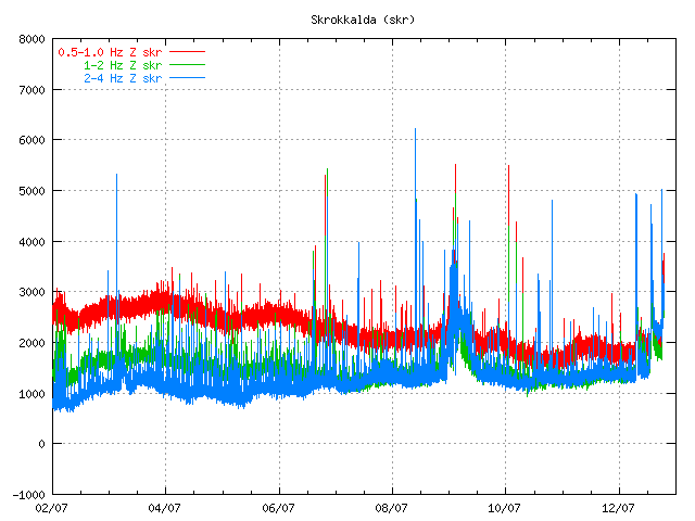
The tremor spikes are now three on 12. July 2011 at 19:09 UTC. Copyright of this picture belongs to Icelandic Met Office.
On the 13. July 2011 the tremor plot looks like this. But at that time the glacier flood had started and broken from the Vatnajökull glacier.
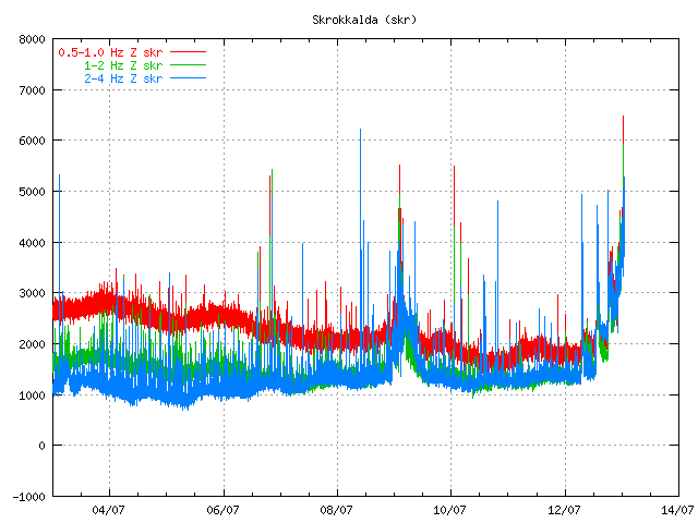
The tremor chart at 13. July 2011 at 01:10 UTC. Copyright of this picture belongs to Icelandic Met Office.
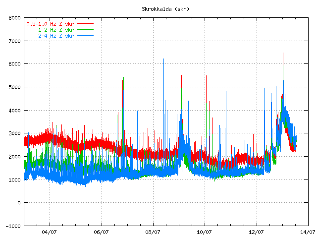
The tremor chart at 13. July 2011 at 12:59 UTC. Copyright of this picture belongs to Icelandic Met Office.
Then there was a short period of break when nothing interesting happened in Hamarinn volcano. That break did last until 16. July 2011 when a new, but smaller spike did appear on Skrokkalda SIL station.
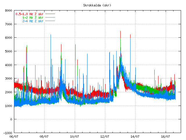
The tremor at 16. July 2011 at 15:22 UTC. It is not fully clear what did happen at this time. But this was most likely a earthquake in Hamarinn volcano. But that is yet unconfirmed at this time. Copyright of this picture belongs to Icelandic Met Office.
Then there is a new break that lasts until 1. August when a earthquakes happens deep under Bárðarbunga volcano. But the deepest earthquake had the depth of 25.2 km. But it is also important to notice this earthquake that took place on 13. July 2011 and it is from Hamarinn volcano.
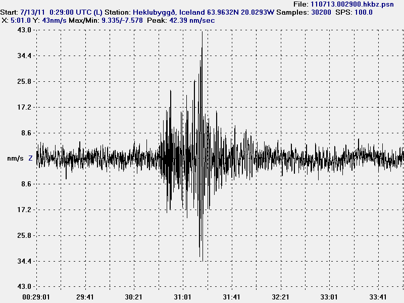
The earthquake from Hamarinn volcano. This picture is released under Creative Commons licence. Please see licence web page for more details.
On the 3. August 2011 around 02:00 UTC a new harmonic tremor spike starts to be visible on Skrokkalda SIL station.
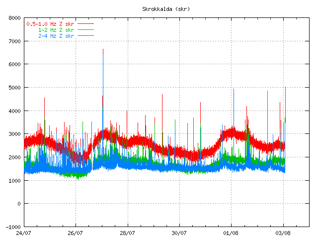
The tremor plot at 01:55 UTC on 3. August 2011. Copyright of this picture belongs to Icelandic Met Office.
This day two minor harmonic tremor happens. A change in Skaftá glacier river is noticed. That is higher conductivity and slightly more water. It was announced in the news that a Skaftá glacier river flood was about to start from the eastern glacier cauldron that is formed above the Hamarinn volcano. Today however that does not seem to be the case. As no glacier flood has taken place so far.
Today (5. August 2011) there was a new harmonic tremor spike on Skrokkalda SIL station. It did follow the same pattern as before. It started and lasted for about 20 to 60 minutes or about that long.
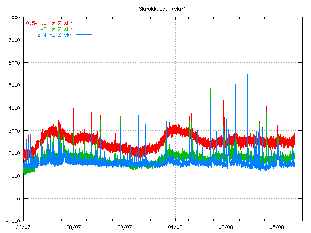
The tremor chart 5. August 2011 at 17:38 UTC. Copyright of this image belongs to Icelandic Met Office.
So far today only one harmonic tremor has been detected. But given the past experience that is unlikely to hold for a long time now. But it is impossible to know when a new event starts or how big it is going to be.
The original event on 12. July 2011 did create new cauldron in the glacier. This map from Icelandic Met Office shows the location of those new cauldrons. But it has been marked with a star on the map. The coloured dots are earthquakes in this area over the past few years.

Map of the area that is currently active in Hamarinn volcano. Copyright of this image belongs to Icelandic Met Office.
Given the current data I am expect a full scale eruption in this area soon. When is hard to know for sure. But until that happens there are going to be more smaller eruptions in this area. I do not know why there is a lack of earthquakes following this events. I cannot explain it. But because of that this can only be seen after it has started on the tremor charts.

Very Interesting read, thanks Jon! 😀
Let’s see the following points:
– Bardarbunga has the longest fissure region in Iceland, almost reaching Torfajokull, and including Veidivotn and Hamarinn regions to its southwest.
– Bardarbunga system does not have a visible eruption since 1862 and 1910.
– Nearly always past eruptions have happened in fissures to the southwest and rarely in the caldera. This could be in Hamarinn, or in Veidivotn (a little bit further southwest outside the glacier). Some of these eruptions have produced incredibly massive amounts of lava (and also ash, suggesting that they can occur in simultaneously in glacial and ice-free locations) such as in 1477; other occurred were much smaller (VEI2) as in 1862 or 1910.
– Except for often earthquakes in Bardarbunga and recently in Hamarinn, the whole fissure region to the southwest is nearly without earthquakes. Why, it is unknown. It could be that earthquakes only happen when eruptions are about to happen. Even now, few earthquakes happen in Hamarinn.
So, as you say, Jon, it could be that Bardarbunga will have a fissure eruption in the near future. This could range from relatively small as in 1910, to massive global-impacting as in 1477. It seems it depends how long will the fissure reach, how far from the central volcano and into the ice-free highlands. I don’t know whether there is a way of knowing this. We would expect activity to be confined to Hamarinn, unless earthquakes start happening to further southwest.
– To complicate things, the cauldrons seems to form a line (fissure) from Grimsvotn western side. We do know that magma from both Bardarbunga and Grimsvotn can feed an eruption as in 1996, after which it seems there was also a very minor eruption right in Bardarbunga which actually cut through the glaciar, and produced some ash. But this was much minor than the 1996 eruption in Grimsvotn/Gjhálp.
What I think we do know; the whole are southwest of Hamarinn is full full of ridges, crater rows and very long fissures, all parallel to each other, a geological record of massive lava eruptions happening there. But these fissures are not volcanoes per se. They belong either to Bardarbunga, Grimsvotn or Katla. And earthquakes almost always never happen there (and this is a rift zone). This has always intrigued me in Icelandic geology., because it is an exception to all the rest of the Icelandic rift and volcanic zones, which are usually full of earthquakes happening.
Very Nice Irpsit. Cogent, to the point and informative. You should have been an analyst for management 🙂
All seems quiet… Too quiet…..
Forgive me the offtopic. There is a severe geomagnetic storm at the moment. If you have good weather, please have a look at your north horizon!!!!
That is if you are not inside a city and you have a dark north horizon. You might see the northern lights tonight, almost from anywhere in Europe, if the forecast is correct.
Auroral activity is extreme at the moment but here is Iceland is still day and overcast.
Nothing to see here in urban-Holland little overcast, cell phone is also functioning normally.
Thank you Jon and Irpsit. Two very interesting Posts. Is there a map showing the topography of the area with the Ice cap removed anywhere? As you say the lack of earthquakes here is strange.
All we can do now is watch and wait.
OT. Has anyone ever seen the Aurora Borealis on any of the Iceland cams? I have had an amber alert from the Aurora watch site based at Lancaster University . A large CME is presently hitting Earth so chances of seeing the aurora are possible from tonight.
There is an orange glow on the lagoon Web cam, but I don’t know if it is aurora because I thought that they were green. I also don’t often look at that web-can at night, so it might always be there. I’ll try to grab a screen-shot and upload it.
One thing I can confirm is that there is definitely no aurora here in the Midlands, UK!
If any would become visible it will probably at one of these webcams since these have relatively high quality and relatively little overcast:
Isafjordur
http://webcam.isafjordur.is/home/JViewer.html
Blonduos
http://212.30.214.249/view/index.shtml
http://img.photobucket.com/albums/v255/cathy_c/lagoon.jpg
http://live.mila.is/lonid/
Probably nothing! 🙂
This is probably the setting sun. Remember that there is hardly any night during summer in Iceland. This glow is probably the setting sun behind the mountain. Around this time of the year it only really gets dark in valleys which are in the shadow of a mountain on the westside. I remember being in the Landmannalaugar hotsprings untill like 12pm-1am without needing any flashlights to get out and make my way back to the mountain hut. Also it was kinda weird getting up at 4am for my flight and waking up with the sun in my eyes!
Ok, thanks. A web-cam is likely the closest I will ever get to seeing an aurora in real life (I refuse to fly in aeroplanes – too scary!), but I guess that I’ll have to wait for another time!
Try the ferry to Iceland!
http://www.ferrylines.com/en/europes-ferry-booking-portal/
From Harwich to Denmark, and from Denmark to Iceland!
I am watching the northern light right now. It started about 15min ago, but the sunset sky is still too bright. There is only one faint star visible, but the aurora makes well visible arcs, quite bright even to lighten when seen through the clouds.
I think this will only be visible in South Iceland. In North Iceland it is even more brighter the sunset sky.
Well how about this:
http://www.vestmannaeyjar.is/?p=100&id=2258&u=2258
Wow! 🙂
Pics, please!
@ Cathy thanks for that. No Aurora here either 🙁
I thought the orange glow could be lights from the airport or Reyjavik .I have only seen the aurora once in UK. I lived in Devon then and the sky in the north was red and turned a deep crimson. that was in 1956!!! It scared me!
@ Pieter. Yes! Must be odd having sunshine so early. It happens here only towards the end of June . I notice early mornings as my husband goes to work at 4.30 am.
No problems here with cell phones or internet.
Its still too much light in Iceland. Besides that: Try the webcam at the “Imagine Peace Tower”, which is sensitive enough to show northern lights:
http://www.earthcam.com/cams/iceland/reykjavik/
Thanks Chris I have saved that link for future. Lovely sky.
@Jon Freyr, what are your thoughts on Hengill volcano.. it is an active volcano and the only one classified with the Reykjanes peninsula that has a magma chamber and is closing in on a due-date (~2000 years) as the rest of Reykjanes. Have you seen any signs lately of suspicious activity there?
I have wondered about this too as there has been a little group of Quakes close together there.
That’s probably either tectonic faulting or a result of a hydrothermal installation. I remember we had quite an impressive man-made earthquake swarm there some time ago.
@Jón Frímann, afsakið forlåt exscuse me….
Have a look at etna*** wow***
Irpsit:
We have had I major black-out here in Rio, around 15:00 UTC. Electricity, internet, cell phones… everything went off for a couple of hours.
Is it possible to be related to this solar flare? Can they reach such low latitudes?
Yes they can and our power grids are very vulnerable to these strong solar events
Due to the Van Allen belt shielding earth there are normally no effects above 40 degrees south and 40 below north. So your power outage has nothing to do with it as long as nobady has moved Rio during my absence.
To be correct here, in the southern hemisphere it is aurora australis, not aurora borealis. Normally solar storms only affect degraded or otherwise neglected powergrids like the north american. Sturdier and more well keapt systems are not affected. As always, money talks. But since few countries are affected due to the Van Allen shielding, about the only two countries affected negatively are Canada and the US, the rest have to sturdy grids.
Carl! Glad to have you back!
Well, I think the state of our powergrids are way worse than those in Canada and the US.
I bet if you strike a match in Sweden, it may cause some disturbs here.
And I understand there is a hole in Earth’s magnetic field somewhere over the South Atlantic, so…
Yepp, that hole is called the south pole;)
I think your poweroutage was quite simply just an ordinary poweroutage… Boring, I know:)
A week ago I saw a rapid series of lightning bolts eradicate a power substation. Spectacular show when the transformers blew up. Less spectacular hour without electricity… 🙂
That hole is not the magnetic pole, it is the south atlantic anomaly: http://en.wikipedia.org/wiki/South_Atlantic_Anomaly
@Carl,
Been missing ya! Happy to see you back…
In 1989 Quebec had no electricity for 9 hours, because of a big solar flame. The closer to the poles, the easier the charged particles can enter the earth atmosphere.
Short after in 1859 a telegraph connection was established between Europe ans the U.S., it was allready out of order, because of a short-circuit, caused by a major solar flame. There was even a fire. The “northern” lights were then visible even in Rome!
Henk Weijerstrass
Holland
Etna is very active
http://www.etnaweb.net/nunziata/webcam.php
Correct Carl but this storm is very strong and all latitudes are affected.
This one is 100 times smaller than the one that caused problems in the nineties in Canada and the US. This is by far not strong enough to even affect below the fiftieth.
The Van Allen Belt is comparatively so much stronger than the solar storms hitting earth since measurements started that nothing sofar has been able to punch through and cause problems below the fiftieth. That would take a hard plasma burst. We are talking tens of orders of magnitude greater.
What I am trying to say is that if all latitudes would ever be affected, we would be gone due to radiation.
If you guys want to have fun, set a radio to the oxygen band, normally it is dead quiet, during a really powerfull solar storm you can here a wee bit of static. Remember that we are talking about fractions of a watt per square metre.
What happens when a solar storm hits is that the power grid starts to act like an antenna, and collects a bit of surplus energy, only grids working at the margin of peak capacity with sub-capacity transformers will be affected.
Let us say that a normal powerline carries 700 000 volts at 1048 amps (normal north european powerline) that would be about 700 000 000 watts. And then we add the solar storm power at 0.01 watt per sqaure metre of surface. And the cable is one decimetres wide so… 0.001 watts per metre of cable. A normal cable is anything between 1000 to 2000 kilometres long so the total added wattage would be… …between 1000 to 2000 watts. Not much really… Now, take a tv-antenna cable that is 100 metres long, loop it and put that under the powerline and connect a lightbulb and watch it glow happily and brightly with about 50 watts. Ie, the loss of power is greater than the surplus energy comming from the sun. So, when the north americas had its poweroutage, well I have a hard time understanding how it actually happened. It should never have been physically possible. I now the grid was really bad, but still…
Nice post, Carl. Plenty of realism to wash out any fear-mongering hype… Hopefully!
And Burfell had a small hickup… And no, solar storms does not affect analogue strainmetres… 🙂
http://hraun.vedur.is/ja/hekla/borholu_thensla.html
Wow, I’ve never seen the scale measuring thousands “strain counts -1”. Or have the changed the scale? It is sometimes nanostrain. Can someone explain what we are measuring, what the unit is, I think I’ve asked before, but not really grasped.
The strains now seems to have been lost completely and the scale is now measured in increments of 100000.
The BUR analogue strain meter has had many faults recently.
Carl,
good to see you back and active again on the blog. I always enjoy your considered contribution to discussions.
A quick comment on the aurora, it was seen very well in Germany, so people from the UK on here wern’t looking hard enough or the clouds/town lights ruined the display 😀
Great post Jon! Great log of all recent events at Hamarinn
We had heavy cloud and we are near the huge conurbation of Manchester. The orange sodium lights here reflect horribly off cloud so we have often a nasty glow in the sky. When it is clear it’s not too bad and hopefully we would be able to see the aurora. I keep looking!!!
Not a lot even in the darker parts of North Yorkshire … gave up looking at 0100
Some of us in the UK had our eyes open, saw a few short displays of pale aurora here in the south west of the UK tonight
I live to the south of London so I didn’t even bother trying to see them. My north view is light polluted sky.
It was cloudy where i live in Somerset for a large part of last night, so nothing for us!
Inflation at Hekla keeps going strong:
http://hraun.vedur.is/ja/gps/predorb/haud_enu_p.png
http://hraun.vedur.is/ja/gps/predorb/isak_enu_p.png
A few tremors occuring now north of kverkfjoll.
I’ll be interested to see what happens today.
People seemed to have missed what appeared to have been a small swarm of earthquakes around the Vatnajokull area, only mentioning it because of there size (one reaching over 2.0) However they are so spread out they are probably nothing to worry about! 😛
Three sleeping mountains gather breath
And spew out mud, and ice and death.
And earthquakes swallow town and town,
In lands as yet to me unknown.
just look at this
http://hvo.wr.usgs.gov/kilauea/update/archive/2011/Mar/PuuOoCollapse_03Aug2011.mov
Spooky! what is happening? Is this rare? and what does it mean?
Awesome!!! Thanks Inka!!!
this is really uncomfortable to watch… like someone pulled a plug somewhere.
this has happened numerous times before.
http://www.bigislandvideonews.com/2011/08/04/video-hawaii-volcano-update-dramatic-puu-oo-collapse/
Please note that there is a noise on a SIL seismometer close to Dalvík. It is creating false earthquakes on the automatic earthquake list on Icelandic Met Office web page.
Thanks for explaining Jon – did wonder what was going on ! Also one of them was nearly a 4 but they weren’t marking it with a star..
It is not marked with a star, if the quality is not adequately high. I do not know what is the limiting value, but I think it may have to be at least 0,70 to get a star…
A quick way to check is to look carefully at the earthquake dots on the map. According to the IMO website the dots with a light gray circle indicate that the earthquake source is from automatic processing. The dots with a black circle around them have been reviewed and corrected.
Looking at another error.
http://hraun.vedur.is/ja/oroi/allarsort.html
Check out hella station, Blue is off the chats.
and it is not recording this morning!
Carl le Strange a warm welcome back.
Thank you Jon for explaining this. I looked at the SIL stations around Dalvik and only one had a quake. I really started wondering how this could be with a potential 4M!.
Carl is back!?! Great!
Right now we have Aurora Borealis (northern light) over the Oslofjord here in Norway. Amazing phenomenon
Beautiful day on Hekla Webcam!:
http://www.ruv.is/hekla
😀
Looks like activity around Askja is stirring up. 1.2M quake at 2km with 99.0% quality in the caldera.
Ok, this is getting strange now, there is * DEFINITELY* something going on at that particular spot at the bottom of the Myrdalsjokull glacier, my theory is it is a weak spot where magma is finding a way to the surface, or perhaps… it is just ice quakes?
Although I still do not expect an eruption at Katla in the next few months!
The earthquakes occurred in that spot in the last 60 days appear to be mostly concentrated at two different depths:
http://i.imgur.com/qK8dG.png
Correct me if i am not correct, maybe not Magma related after all. For me, the EQ’S at 0.1 KM and 5.0+KM are to far apart and there is no EQ’S in between. Now maybe they are and its not getting picked up.
Would we not see a raise in some of the stations around the area and have harmonic tremor spikes on GOLA too? Thanks Moho for doing the plot.
Well Alftagrof (ALF SIL station) has been showing some activity. And that is the closest one i think.
The Mila and RUV webcams are showing Iceland at it’s absolute best, glorious; eruptions or not, long may it remain so!!
I am going to be off-line today from 90:00 UTC and until tomorrow around 20:00 UTC. I got things to do and I won’t be in good internet connection during that time.
I am going to have my mobile. But I won’t be able to comment or post here with it. So if something happens, just talk about it here in the comment until I an make a blog post about it.
That’ll mean surely something will erupt!
Which volcano will erupt next? There’s so many threatening to at the moment! My moneys on Hekla or Askja!
Askja will not erupt in the near future (at least not within a few years), as it has been deflating for several years now.
I just returned from a amazing weekend over Kerlingarfjoll, a geothermal area between Hofsjokull and Langjokull, of a central volcano long dormant. The view from there is staggering (1500m high), I could see all the way from the West Fjords to Vatnajokull. The weather today was extremely clear. Over Vatnajokull, which is both black (ash) and white I could see the new depressions in the ice cap, above Hamarinn, with Bardarbunga nehind, further east (it is the second tallest peak in Iceland). From grimsvotn I could see the ash being blown way westwards until above Hekla which towered over the South and is very prominent against any other mountains in the South. Eyjafjallajokull, 1600m is also very prominent. This makes today one of the best hikes and views I ever had in my life. I seriously recommend it to everyone. Just to share this off-topic, which is volcano related anyways.
The reading itself fantastically and when I look at it now imagine …. I green with envy
I like the thought of seeing the new depressions in the ice cap, above Hamarinn, Vatnajokull part black part white, etc.
I love the scenery where I live and am out walking most days.
A very lucid description there Irpsit, almost transported me there. Nice.
Irpsit,
Thank you very much for sharing your impressions with all of us! You are a good writer. Wish I could see all the wonderful views you describe. So my question is: Did you take pictures, and if yes, would it be possible to see them on the internet?
Irpsit:
What a great depiction of your trip!
Did you grab some shots to show us? I would love to see. 🙂
Unfortunately my camera just died two weeks ago. And died in a funny way. I used it when Grimsvotn erupted to go to Kirkjabaerklustur, 50 away from the volcano, during that day’s volcanic night. I thought the camera would die right that day, but surprisingly it survived after May’s eruption, although the zoom never worked again. A couple of weeks ago, the camera just stopped working (the lens are stuck due to ash inside). I tried many times but it doesn’t work anymore. So, I was unlucky, having the best view and could not take a single photo from it, but I asked another guy that also hiked up there to mail some pictures, so I will wait for it. To have an idea, you can go google earth, Kerlingarfjoll and browse the pictures from those tops.
Looks interesting!! any ideas?
http://live.mila.is/eyjafjallajokull-fra-thorolfsfelli/
I see the plume!
Sheep alert!!!
http://www.ruv.is/katla
http://hraun.vedur.is/ja/hekla/oroi_hau.html
Any thoughts on the small spike today?
How about the recent one, mayby from the recent earthquake near Katla?
http://hraun.vedur.is/ja/hekla/oroi_hau.html
http://hraun.vedur.is/ja/Katla/oroi_esk.html
Whatever it was, it was surely caused by magma, because of the unclear P and S waves at Jon’s helicorder, and the low-frequency component of the tremor spike.
Mag 2.2 depth 1.1 Habunga
Jon’s helicorder recorded a strong, and/or nearby earthquake.
http://www.simnet.is/jonfr500/earthquake/tremoren.htm
My first thought was the M2.7 at Langjokull, but that occured 3 minutes before it appeared on the helicorder..
We were up at Laugafell today- not too far away from you Irpsit?! Was an exquisite blue day. Not close enough to see the area you’re talking about but think our view took in Hofsjokull & a bit of Vatnajokull. Water in the hot spring certainly smelt quite sulphuric but expect this is typical.Am holding my breath all the eruption predictions here don’t come to pass in the next month! Have my Iceland geology book to read now and a geological map so starting to put more info together to understand the terms being thrown around on this blog… heading near Krafla, & Myvatn geothermal areas in a couple of days… hoping for more quiet 🙂
No, this is correct quake on Jons geophone, the 2,7 was 22:50.52, the small one before is from Katla
http://hraun.vedur.is/ja/skjalftar/skjlisti.html
(meant at Pieter);
BUT THERE seems be FLURRY of QUAKES tonight, best watch for a while …
http://hraun.vedur.is/ja/skjalftar/skjlisti.html
While Jon’s away the volcanoes will play! 😉
(And Irpsit, great description, thank you! I too would love to see some photos, preferably annotated if you have the time, to get a sense of scale with your hikes).
It’s probably just clouds on the far side of Eyjafjallajokull but there is some strange white effect on the very left of the live cam from Þórólfsfelli – it doesn’t appear on the right hand side so I’m ruling out some sort of chromatic aberration on the lens
08.08.2011 10:09:20 63.642 -19.218 4.3 km 0.5 46.95 1.6 km E of Goðabunga
Climbing up?
There is a line of earthquakes all the way from Reykjanes peninsula, along Langjokull, Blonduós, and then to Dalvík, in the north. This is interesting as it is to be the supposed old rifting belt. I don’t think it is a coincidence that these earthquakes close to Langjokull and Husafell happen more or less at the same time as in Blonduós. It is I think the second time I see this happening, and now at the same time as those earthquakes in Dalvík.
Interestingly, this occurs only a few days after some stronger quakes in both extremities of Iceland, in Tjornes and offshore of Reykjanes. Could there be a relationship? I have seen this pattern before, more than a couple of times.
I know that accordingly to geological theory, there should not be this causal link, but scientists have made bigger causal links on the past, for example in Indonesia and Chile, with earthquakes triggering other nearby faults (and even volcanic eruptions) some hundreds of kms away. So why not assume the same causal link along the same tectonic-volcanic belt in Iceland. As I say, I see this pattern happening in Iceland and other parts of the world, more than often to be assumed as a mere coincidence.
I also don’t think this happens always. It is probable that sometimes nearny tension in one side of a tectonic fault, can affect or trigger earthquakes in another close by fault or volcanoes (and geologically speaking, 150km is very little distance). I think this causal link can happen sometimes, not always, and that is the problem why it has been not confirmed by mainstream scientists; if it does not happen too often it cannot be reproducible theory.
Jon said that the quakes in Dalvik are caused by noise..
The rest of the quakes do indeed line up nicely.
I agree with you that it’s probably not only coincidence that this happens. Imagine you have 3 points between the plates, A and C at the ends and B in the middle If the plates move apart in place A and C it makes sence that the plates will also move apart at place B.. Because at place B the plates are still “most connected” and at this place it is likely that the plates will move next..
Sander
The Grimsvotn Cam hasn’t worked for ages (for me, anyway) but it seems to be back on-line now. Only thing is, the scene looks very different – can anyone identify if they have moved it?
Thanks!
http://live.mila.is/grimsvotn2/
Answered my own question… from the cloud similarities, I think it is now pointed at Katla. Hmm!
Seems new view of Katla Volcano (only direction seems changed. Previous posts had this camera located not close where it actually was). Previously it showed part of Múlakvísl river and Hafursey. Now it points North or North-West (an change of 45 to 60 Deg I think).
Strong inflation at Solheimaheidi (Katla)
http://hraun.vedur.is/ja/gps/predorb/soho_enu_p.png
Really? Does this mean anything? And over how long a period of time?
P.S: Sorry for the mound of questions! 🙂
Well the current inflation is really sudden and therefor it could be due to instrument failure. I can’t exactly tell what it means, but as always with uplift, it could indicate a magmatic influx in the magma chamber, which because of this expands. However mostly this is accompanied by earthquake swarms and/or tremor, which isn’t the case. So just wait and see.
My best guess? Data glitch.
Still 4o+ mm is highish. for me, i recall its added under 10mm this year.
It could mean Reykjavik is sinking – just teasing
Found this link, 3 months of data.
http://strokkur.raunvis.hi.is/~sigrun/KATLA11.html
By the way:
Hamarinn GPS data long term
http://strokkur.raunvis.hi.is/~sigrun/HAMAdet.png
Very interesting ;D
Very interesting – Any bets when it will erupt?
Activity at Katla seems to be slowly but surely increasing almost unnoticed! :O
LAgu Hvolar is showing a long period, isn’t it?
Irpsit:
I agree with you. I have already placed many comments about this “pattern”.
No idea whether it is a scientific statement or not, but it has been a year or more that I have seen it repeated.
And the explanation provided by Sander makes sense to me.
I’m concerned about this spike in Lagu Hvolar. It is really noticeable. A new hlaup underway?
Sorry to be off topic, but if anyone wents to see a good helicorder response to a quarry blast, log on to the BGS helicorder site for today, drop list to CWF – Charnwood Forest and short period – ie close range plot, and at 12.46BST blast response. For those not local, Charnwood is an area of Pre-Cambrian intrusives – diorites and granodiorites extensively quarried for roadstone.
http://www.earthquakes.bgs.ac.uk/helicorder/heli.html
Also 2x mag2 earthquakes in UK on 04/08/11
Barnard Castle select Keswick
Leominster select Longmynd HLM
both short period
I live just over half a mile from Bardon quarry, I don’t need any recording equipment to feel the daily blasting!
I remember it well – much more peaceful in Yorkshire than NW Leics!
I am back. New blog post after I have just cached my breath so to speak.