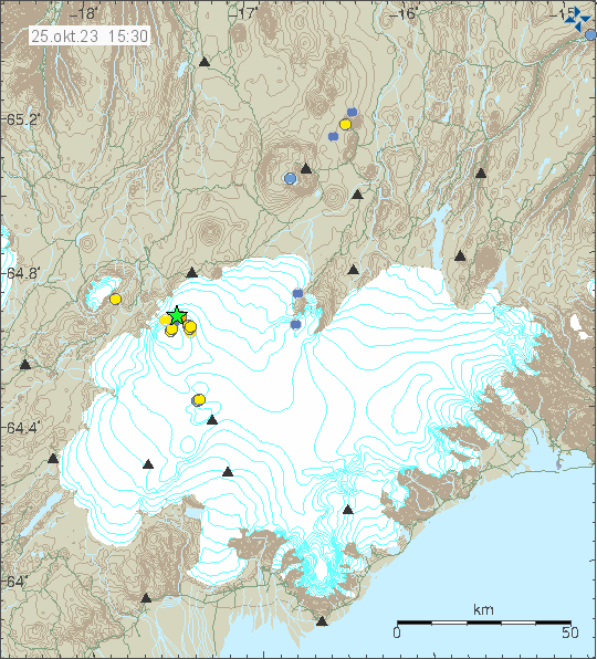
Yesterday (24. October 2023) at 22:19 UTC an earthquake with magnitude of Mw4,9 took place in Bárðarbunga volcano north eastern part of the volcano. This time it was not in the caldera as is the most common location for this earthquake activity.
Earthquake activity in Bárðarbunga volcano. Copyright of this image belongs to Icelandic Met Office.
This is a inflation connected earthquake activity in Bárðarbunga volcano. This is the second earthquake this year that reaches magnitude of Mw4,9. There is no risk for an eruption in Bárðarbunga volcano at current time.
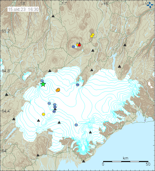
Yesterday (14. October 2023) an earthquake with magnitude of Mw3,6 took place in Bárðarbunga volcano. This is one of many inflation earthquakes that have taken place in Bárðarbunga volcano since end of the eruption in 2015. This earthquake activity is going to continue for the next 50 to 100 years if nothing changes, but with rate of earthquakes getting lower as the time passes.
The activity in Bárðarbunga volcano. Copyright of this image belongs to Icelandic Met Office.
This earthquake activity is normal and won’t result in a eruption. This type of earthquake or larger happen currently every two to three months in Bárðarbunga volcano.
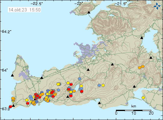
Icelandic Met Office reported today (14. October 2023) that an new eruption in Fagradalsfjall volcano or nearby is now expected to happen before or close to Christmas. After the end of the eruption on 6th August 2023 the inflation that has been happening is now faster then before earlier eruptions. At the writing of this article, an earthquake with magnitude of Mw2,7 took place north of Grindavík town and was felt in Grindavík.
Earthquake activity north of Grindavík town and in Fagradalsfjall volcano. Copyright of this image belongs to Icelandic Met Office.
In the last two eruptions, after the first eruption ended. There have been around ten months between eruption. That does not seem to be the case now. Since it seems that next eruption is going to happen at four to six months time. A half or close to it from when the last eruption took place. This situation is dangerous, because this means that an eruption can start without much warning and not a lot of earthquake activity. Icelandic Met Office advice is that people travel around and in Fagradalsfjall volcano carefully.
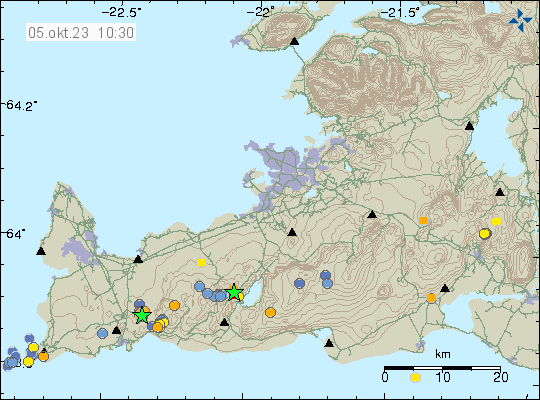
Today (5. October 2023) two earthquakes took place that are connected to Fagradalsfjall volcano inflation. The first one was a magnitude Mw3,3 in Krýsuvík-Trölladyngja volcano. This was a tectonic earthquake because of inflation in Fagradalsfjall volcano. The second earthquake was north of Grindavík town and had a magnitude of Mw3,2. That earthquake was part of an earthquake swarm and dyke intrusion in that area. That area north of Grindavík town has been seeing a lot of earthquake activity in recent weeks, all connected to dyke intrusion activity.
Two green stars on Reykjanes peninsula. Copyright of this image belongs to Icelandic Met Office.
The increase in activity in recent weeks strongly suggests that an eruption is going to happen soon. When is impossible to know and earthquake activity is too low at the writing of this article for an eruption to be happening today. This might change without warning, as has happened in the last two eruptions. There is a possibility that something has changed after the last eruption, but the answer to that question won’t happen until next eruption. All that can be done now is to wait and see what happens.
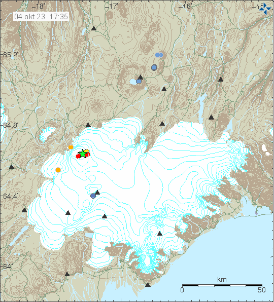
Today (4. October 2023) at 16:11 UTC an earthquake with magnitude of Mw4,7 (Icelandic Met Office) or Mw5,0 (EMSC) took place in Bárðarbunga volcano.
Earthquake activity in Bárðarbunga volcano. Copyright of this image belongs to Icelandic Met Office.
This is normal inflation earthquake in Bárðarbunga volcano and large earthquakes like this happen every few months. This means that Bárðarbunga volcano continues to inflate after the eruption in 2014 to 2015. This earthquake activity is not going to result in a eruption and won’t result in a eruption for a long time.
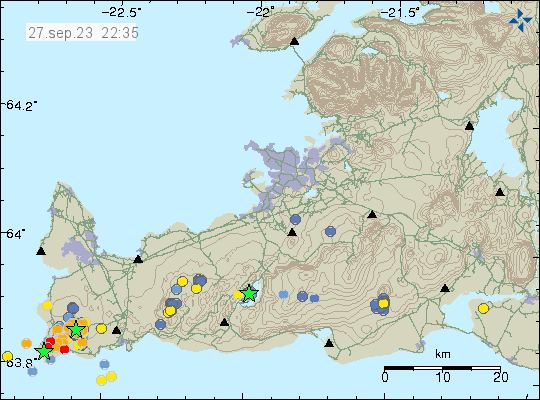
Today (27. September 2023) an earthquake swarm took place in Reykjanes volcano on Reykjanes peninsula. This earthquake swarm is ongoing at the writing of this article. At the writing of this article, the largest earthquake had a magnitude of Mw3,3 and the second largest earthquake had a magnitude of Mw3,1.
Earthquake activity in Reykjanes volcano. Copyright of this image belongs to Icelandic Met Office.
The source of this earthquake swarm seems to be magma intrusion into this part of Reykjanes volcano. I don’t know if this is going to result in a eruption, this earthquake activity seems to be too low for that to happen. That might change without warning, as sometimes happens with volcanoes. This is at least highly active time period now and what is going to happen is unclear.
I am sorry that I am late on writing this article. I was moving from Denmark to Iceland and that was a lot of effort and I’ve been tired after this move.
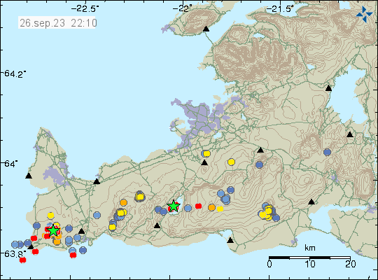
On Sunday, 24 September 2023 an earthquake swarm took place in Brennisteinfjöll volcano, in a area called Geitarfell (Goat Mountain) in Brennisteinsfjöll volcano. Largest earthquakes had a magnitude of Mw3,0 to Mw3,2. A lot of smaller earthquakes took place at this same location.
Yellow dots show the Sunday earthquake activity. Copyright of this image belongs to Icelandic Met Office.
This earthquake activity didn’t have any short term signs that an eruption is about to happen at this location. I don’t know when last eruption took in this location, but it was clearly more than 6000 years ago.
Earthquake webicoders
Since I have moved back to Iceland. I am now recording earthquakes again. The webicoders are going to go online tomorrow (if no delays). They can be found here once they are back online.
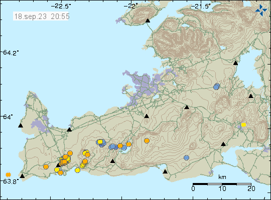
Today (18. September 2023) there was an earthquake swarm north of Grindavík town. Largest earthquake had a magnitude of Mw2,7 and was felt in Grindavík town according to Icelandic Met Office. This earthquake activity has the direction of SW to NE and is under the road to Grindavík town.
Earthquake swarm activity north of Grindavík town. Copyright of this image belongs to Icelandic Met Office.
This is clearly a dyke intrusion taking place at this location. This location is bad, because this area has infrastructure that is important to Grindavík town. In this area both hot and cold water is transported along with electricity wires (I think, they might have a different path, but it is at most nearby). Eruption at this location would be a major hazard and a problem. Currently there are no signs that this magma is looking for a path to the surface.
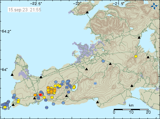
Yesterday (15. September 2023) an earthquake swarm took place on Fagradalsfjall volcano. This earthquake swarm wasn’t in the news because it was only small earthquakes, that is earthquakes with magnitude less of Mw1,0. It was not even felt by the people standing on the volcano because of depth. If this earthquake swarm has stopped I don’t know. Since most of this earthquakes don’t show up in the automatic earthquake list at Icelandic Met Office website. They only appear after a manual review by Icelandic Met Office.
High earthquake activity in Fagradalsfjall volcano. Copyright of this image belongs to Icelandic Met Office.
In my view, this means that next eruption might happen between November to February 2024 if this earthquake activity and dyke intrusion activity continues as it is currently doing. It has happened before earlier eruptions that a high period of activity is followed by a period of quiet until an eruption happens. Why that is I don’t know, that is a pattern I’ve observed. I don’t know if there has been change after last eruption in Fagradalsjall volcano. That is a possibility that should not be ruled out.
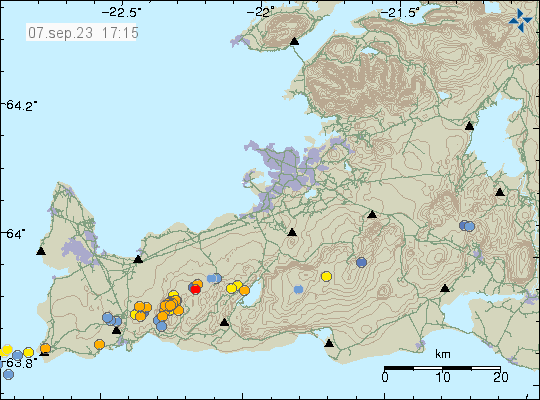
Today (7. September 2023) an tyke intrusion took place in Fagradalsfjall volcano. The main depth of the dyke intrusion is at around 7 km depth. All earthquakes following this dyke intrusion where small in magnitude, from Mw0,1 in magnitude and up to Mw1,0 in magnitude. This seems to be a rather large dyke intrusion, since part of it does not create any earthquake activity at all because of earlier dyke intrusions at this depth in this part of Fagradalsfjall mountain.
Earthquake activity in Fagradalsfjall volcano. Copyright of this image belongs to Icelandic Met Office.
Morgunblaðið (link below) is reporting that inflation has now reached 15mm in this area. This is really soon after the end of the eruption, since in last three eruptions, dyke intrusions and other early signs of activity that an eruption is about to happen starts around three to six months earlier before an eruption happens at the ten month time, as has been the case in the last three eruptions. It is possible that next eruption is going to happen earlier than last three eruptions. It is possible to know when next eruption is going to happen.