Strongest earthquakes in Bárðarbunga volcano since February 2015

Yesterday (26-October-2017) and today (27-10-2017) two strongest earthquake took place in Báðarbunga volcano since end of the eruption in February 2015. The magnitudes of earthquakes so far are two Mw4.7, One magnitude Mw3,9 and one Mw3,2 earthquake. So far other earthquakes have been smaller in magnitude. No harmonic tremor has been detected so far, but given the location an eruption might start in other part of the caldera without warning even if the earthquake swarm activity is happening in the northern part of the Bárðarbunga volcano caldera.


The earthquake activity in Bárðarbunga volcano. Copyright of this image belongs to Icelandic Met Office.


The magnitude 3,9 earthquake as it appeared on my geophone in Dellukot. This image is under Creative Commons Licence, please see CC licence for more details.


The magnitude 3,9 earthquake as it appeared on my geophone in Böðvarshólar. This image is under Creative Commons Licence, please see CC licence for more details.


The second magnitude 4,7 earthquake as it appeared on my geophone in Dellukot. For some unknown reason (maybe bad weather) I was unable to properly record the magnitude 4,7 earthquake at 23:26 UTC. This image is under Creative Commons Licence, please see CC licence for more details.


The second magnitude 4,7 earthquake as it appeared on my geophone in Böðvarshólar. For some unknown reason (maybe bad weather) I was unable to properly record the magnitude 4,7 earthquake at 23:26 UTC. This image is under Creative Commons Licence, please see CC licence for more details.

At the moment no eruption has been detected. But this strong and increasing earthquake activity suggest that magma pressure inside Bárðarbunga volcano might be reaching critical point. If it has not reached critical point already. For the next 24 – 36 hours really bad weather is forecasted in Iceland. With wind gusts forecasted up to 45m/s in the highland and in northern Iceland. This bad weather is going to cause problems in detecting earthquakes in Bárðarbunga volcano and elsewhere.

Donations

Please remember to support my work with donations. Thanks for the support. 🙂

Earthquake activity in Öræfajökull and Kverkfjöll volcano

Since this volcanoes are in the same part of Iceland I am going to write about them in the same article.

Öræfajökull volcano

I don’t think this was a glacier earthquake activity happening in Öræfajökull volcano. I don’t know how many earthquakes took place this time around. Largest earthquakes had magnitude of 2,0 and 1,8 all other earthquakes where smaller in magnitude. Currently there is no GPS monitoring for Öræfajökull volcano that I know of.


The earthquake activity in Öræfajökull volcano and Kverlfjöll volcano. Copyright of this image belongs to Icelandic Met Office.

It is noticing how this time the earthquake swarm is all on the east side of the volcano. This earthquake activity is interesting and this also seems to signal an increase in earthquake activity in Öræfajökull volcano at least for the time being. It remains a question if this activity slows down again. Earthquake activity in this part of Iceland only happens due stress changes in Öræfajökull volcano. This is most likely influx of magma into Öræfajökull volcano but it might not erupt right away or at all (at least for a long time).

Kverkfjöll volcano

A minor earthquake swarm took place in Kverkfjöll volcano today (23-September-2017). Largest earthquake in this swarm had the magnitude of 2,1 and the second strongest earthquake had a magnitude of 1,4. The earthquake swarm was in the central part of the volcano. This is the first earthquake swarm since 2015 in Kverkfjöll volcano and the activity that year was mostly due the activity happening in Bárðarbunga volcano next to it (the dike from Bárðarbunga volcano did disturb Kverkfjöll volcano). Since this earthquake activity took place everything has been quiet in Kverkfjöll volcano.

Donations

Please remember to support my work. At the moment my fridge is getting close to be empty and it is the first time since I moved to Denmark that happens. I hope that next month (October) is slightly better. Thanks for the support. 🙂

Glacier cauldrons at top of Bárðarbunga volcano caldera rim

During the eruption in Bárðarbunga volcano and the collapse of the caldera. A hydrothermal activity was seen on top of Bárðarbunga volcano caldera. Since the eruption in Holuhraun ended in February-2015 this hydrothermal activity has dropped, it has increased if anything. At the moment there are several depressions in the Vatnajökull glacier that is on top of Bárðarbunga volcano. Largest of them are 400 meters wide, I am not sure about their length. This cauldrons are around 100 meters deep and for the first time in several hundreds of years have exposed a bed rock that is normally under the glacier. Hydrothermal activity in Bárðarbunga volcano is now such that is able to melt 100 meters of glacier in several months.

This high amount of hydrothermal activity in the main volcano increases my suspicion that Bárðarbunga volcano is far from over. Since this also means that fresh magma is reaching up to 1 km in the crust in the Bárðarbunga volcano caldera rim. I don’t have any map of the locations of the calderas at the moment since none exist or at least has not yet been published. The main concern now is that this is going to increase the risk of sudden glacier floods from Bárðarbunga volcano. This might also increase the risk of sudden short volcano eruptions in Bárðarbunga volcano, either in its slopes or close to the caldera rim. As it is clear that magma has rather clear access to that part of the volcano.

Rúv News article (in Icelandic)

Gat í gegnum jökulinn (Rúv.is, Icelandic, video)

Donations

Please remember to support my work with donations. Everything helps. Thanks. 🙂

Article updated at 23:51 UTC. Text fixes.

Katla volcano update article of 29-July-2017

This article is going to be updated as activity continues in Katla volcano today on 29-July-2017. If an eruption starts (big one) a new article is going to be written for that event.

Overview of the activity during the night and today

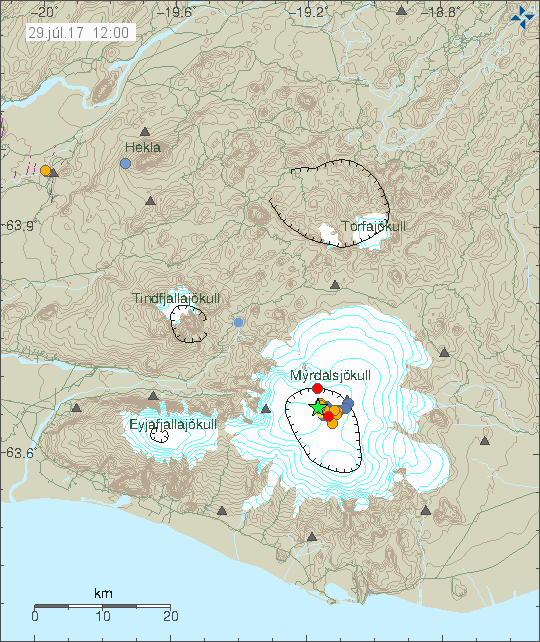
It seems that during the night a minor eruption took place (this is just my view). This based on harmonic tremor pulse that appeared in Katla volcano after midnight, the source of the activity seems to be north-west part of the caldera. Possibly where a magnitude 3,0 earthquake had taken place at 00:48 UTC. Harmonic tremor remains unstable and above background levels, at the moment however it seems that current harmonic tremor when this is written is due to glacier flood pushing it self from under the glacier. The water that is moving under the glacier is few hours away from (at best) from appearing in glacier rivers that come from Katla volcano.


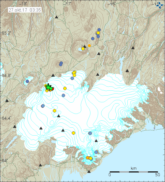
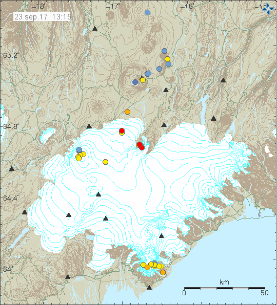
The earthquake activity in Katla volcano during the last 48 hours. Copyright of this image belongs to Icelandic Met Office.


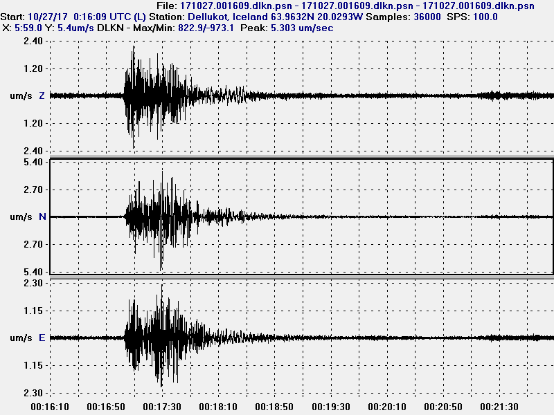
Harmonic tremor in Austmannsbunga in Katla volcano at 12:09 UTC. It clearly shows the minor eruption and ongoing harmonic tremor pulse. Copyright of this image belongs to Icelandic Met Office.


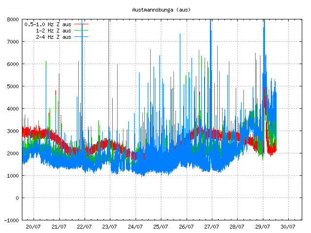
Harmonic tremor in Austmannsbunga in Katla volcano at 13:04 UTC. This image shows ongoing activity in the tremor. This is mostly high frequency tremor and that is interesting. What that is not known. Copyright of this image belongs to Icelandic Met Office.


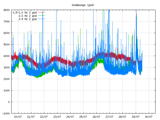
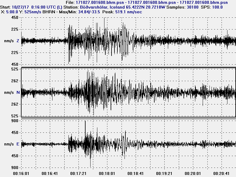
Harmonic tremor in Goðabunga at 12:09 UTC. It clearly shows the night minor eruption and ongoing harmonic tremor. The harmonic tremor is however a lot less visible now on Goðabunga. Copyright of this image belongs to Icelandic Met Office.


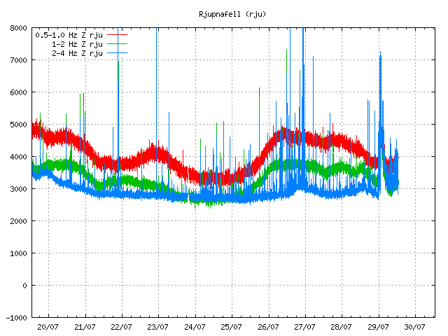
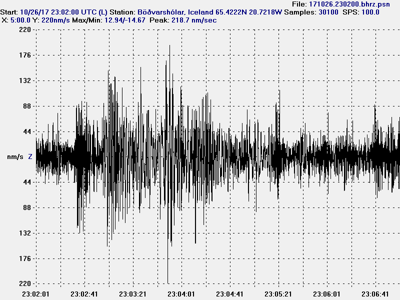
Harmonic tremor as it appears on Rjúpnafell (SIL station). This station is at more distance from the source of the harmonic tremor pulse and shows a weaker signal as a result. The night minor eruption is also clear on this SIL station but current harmonic tremor is less visible, it does appear but at much lower level. Copyright of this image belongs to Icelandic Met Office.

Katla volcano has been moved to yellow alert. It is now possible to watch the glacier flood live from here (Rúv.is). Currently the glacier flood is getting smaller, but that might only be a temporarily thing if more water is on its way from Mýrdalsjökull glacier. There has also been a drop in conductivity for now in Múlavísk glacier river.

Announcement in English on Rúv

People advised to stay away from Múlakvísl (Rúv.is)

This article is going to be updated as needed today.

Update on Reykjanes peninsula earthquake swarm (Fagradalsfjall mountain)

Since 26-July-2017 there has been a earthquake swarm on Reykjanes peninsula close to a mountain called Fagradalsfjall. This earthquake swarm has been one of the larger ones in the area in recent years. Total number of earthquakes that have been detected so far is well over 600 at the writing of this article. There is some magma involved in this earthquake swarm, it has stayed deep in the crust and there are currently no signs of it moving upwards more then it already has at this point. This makes an eruption extremely unlikely, unlike what some news reports about this earthquake swarm might suggest an eruption is not imminent in this area of Iceland.


Earthquake activity close to Fagradalsfjall mountain for the last 48 hours. Copyright of this image belongs to Icelandic Met Office.

Largest earthquake during the last 24 hours is a magnitude 3,2 earthquake that took place at 05:56 UTC. In 1968 a magnitude 6,0 earthquake took place in this same area. I don’t know if that is going to happen now, what is a risk is this earthquake swarm increasing again from current drop in activity. This area is in part a rift valley and plate interaction can get complicated and last for a long time. With quiet period between high periods of activity. At this moment the earthquake activity in this area is decreasing, that does not mean it is over yet, just that a decreasing in activity is currently happening.

Donations

Please remember to support my work with donations. It helps me keep this website running and to report on activity in Iceland. Thanks for the support. 🙂

Ongoing earthquake activity north-east of Flatey in Skjálfanda fjord (north-east Iceland)

Earthquake activity that started in March 2017 in TFZ (Tjörnes Fracture Zone) is ongoing. I don’t know yet how many earthquakes have happened so far, but at last check Icelandic Met Office reported that the mark was at 800 and that was more then a month ago. The fluid that is pressuring up at this location between fault lines is most likely a magma in my view. If that results in a eruption is harder to say, at the moment the magma seems to be stuck at 10 km depth (in or around that depth).


The current earthquake at Flatey in Skjálfanda fjord. The location is where the yellow and orange dots mix (slightly east of Eyjafjörður fjord). Copyright of this image belongs to Icelandic Met Office.

The earthquake activity at this location continues with little signs of stopping. What is also interesting is the fact the magma doesn’t seems to be making any progress up the crust at the moment. With fault line already in place the path to the surface is almost direct in this area if nothing is preventing the magma from moving upwards (impossible to know). At the moment this earthquake activity is limited to minor earthquakes and this magma seems to be lacking pressure to reach the surface at the moment. At this location there are no known volcanoes.

Donations

Please remember to support my work with donations. As it helps keeping me working on this website and paying the bills. Recent donations did exactly that and that is a big support. Thanks for the support. 🙂

Earthquake activity in Öræfajökull volcano (13-June-2017)

Today (13-June-2017) a magnitude 2.6 earthquake took place in Öræfajökull volcano. This is the largest earthquake in this volcano for a long time now and it is worth noting that Öræfajökull volcano normally doesn’t have any earthquake activity. This suggests that something might be up if it doesn’t start to quiet down in next few years. Earthquake activity in Öræfajökull volcano is not high as can be seen in this science paper that covers the years 1994 – 2007 in earthquake activity in Iceland.


Earthquake activity in Öræfajökull volcano (to the south on this image). Some of the activity might be glacier quakes due to summer heat or rain. Copyright of this image belongs to Icelandic Met Office.

Tectonic settings in this area don’t allow for a lot of crustal-tension earthquakes and that suggests that the source of current earthquake activity in Öræfajökull volcano can be explained by magma movements. If this is going to end in a eruption remains to be seen. At the moment current low level activity rules that out, since a lot more and stronger earthquake activity needs to happen before magma can reach the surface.

Donations

Please remember to support my website with donations. It helps me surviving the month. Thanks for the support. 🙂

Weekly earthquake in Bárðarbunga volcano (12-June-2017)

Today (12-June-2017) a magnitude 3,6 earthquake took place in Bárðarbunga volcano. This earthquake activity is mostly normal for Bárðarbunga volcano, there has been slight increase in earthquake activity in Bárðarbunga volcano during the past few days (minor earthquakes), why that increase is taking place is unclear at the moment. This increased happened at the same time as a sharp increase in earthquake activity took place in Tungnafellsjökull volcano (read the article about that for more information).


The earthquake activity in Bárðarbunga volcano and Tungnafellsjökull volcano. The green star shows the magnitude 3,6 earthquake. Copyright of this image belongs to Icelandic Met Office.

Currently the activity in Bárðarbunga volcano is mostly what is now considered ‘normal’ after the 2014 – 2015 eruption. I don’t know if that status is about to change, but there are clues in current activity suggesting that might be about to happen. This increased activity however might slow down again and go back to normal background levels.

Donations

Please remember to support my work. As it helps me to get trough the month of June. Thanks for the support. 🙂

Deep earthquake activity in Trölladyngja (volcano)

Today (08-June-2017) there have been deep earthquakes in Trölladyngja (volcano). This earthquake swarm was shallower than last earthquake swarm that took place in Trölladyngja. Several months ago the earthquakes in Trölladyngja where happening at 28 km depth, but now they are at the depth range of 18,6 – 23,3 km, this means that the magma under Trölladyngja is migrating upwards at fast phase, a lot faster then I thought was possible. Earthquake swarm in November-2015 where slight off to the side, those earthquakes had the depth of 15 – 18 km as I wrote about here. Since November-2015 here has been other activity in Trölladyngja, but that has been in the form of one or two earthquakes so I have not written about it (I never bother with just one or two earthquakes at location due to the amount that happens daily in Iceland).


Earthquake activity in Trölladyngja (volcano), north-east of Bárðarbunga volcano fissure swarm. Copyright of this image belongs to Icelandic Met Office.

Last eruption in Trölladyngja was according to GVP (under Bárðarbunga volcano history) was 7000 years ago. Since then nothing has happened. There has been a lot more eruption in Dyngjuháls area and that area is also having deep earthquakes. That area is also covered with ~200 meters of glacier. It remains to be seen what happens next in the Bárðarbunga volcano saga.

Donations

Please remember to support my work. As it currently stands I’m completely broke and that’s no good at the start of the month. Thanks for the support. 🙂

Earthquake swarm in Kolbeinsey island

Yesterday (24-May-2017) and today (during the night of 25-May-2017) there was an earthquake swarm in Kolbeinsey island. Largest earthquakes had the magnitude of 3,6 (x2) and one magnitude 3,5 earthquake took place. Other earthquakes where smaller in magnitude. No harmonic tremor where detected during this activity, that does not rule out that this activity is due to dyke intrusion taking place in Kolbeinsey island. It just didn’t reach the surface this time. Kolbeinsey island is far away from the SIL network, with the closest station being in Grímsey island (~25 km) with other SIL station at ~60 km distance. If an eruption starts in Kolbeinsey Island, a harmonic tremor signal is going to appear in Grímsey island SIL station.


Green star mark the area where the earthquake swarm took place in Kolbeinsey island. Copyright of this image belongs to Icelandic Met Office.

Last eruption in this area took place in the year 1755, but that eruption might not actually have been in Kolbeinsey Island, but in a other unnamed volcano north of it (where is not known). Last confirmed eruption in Kolbeinsey island took place in the year 1372, it was closer to land somewhere north-west of Grímsey island (suggesting that fissure swarm of Kolbeinsey island comes close to Grímsey island).

At the moment the activity has quieted down and no earthquakes are being detected by the SIL network.

Donations

Please remember to support my work with donations. Thanks for the support. 🙂