Short update on Bárðarbunga volcano at 12:07 UTC

This is a short update on Bárðarbunga volcano. Due to the fast change that is now taking place in Bárðarbunga volcano this information is going to get outdated quickly.

  • Earthquake activity now is extremely dense. With 3 to 5 earthquakes taking place every second (best estimate that I have made).
  • Earthquakes have increased in magnitude.
  • General activity appears to have increased in Bárðarbunga volcano. Even if no major eruption has yet taken place.
  • There is currently no signs of this activity stopping any time soon.
  • The dyke in Bárðarbunga volcano continues to get longer and wider, it is now over 40 km long (I think). Formation of this dyke has slowed due to more difficult crust in the area he is now in (that means more earthquakes).
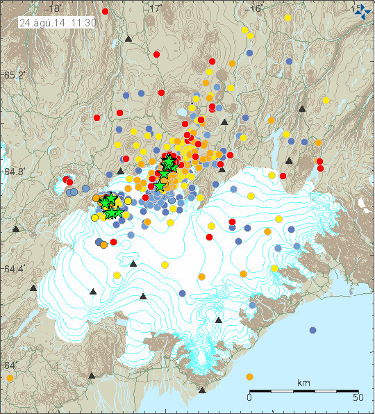
 

140824_1130
The current earthquake activity in Bárðarbunga. Copyright of this image belongs to Icelandic Met Office.

140824_1130_trace
The extremely dense earthquake activity in Bárðarbunga volcano. Copyright of this image belongs to Icelandic Met Office.
dyn.svd.24.08.2014.at.11.33.utc
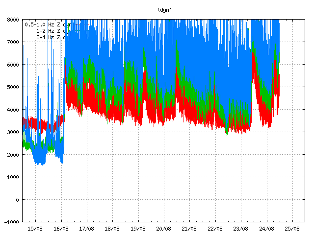
Harmonic tremor is getting off the tremor plot that Icelandic Met Office has on its website. This is the harmonic tremor at 11:33 UTC. This is Dyngjuháls SIL station. It is closest to the dyke at the moment. Copyright of this image belongs to Icelandic Met Office.
ask.svd.24.08.2014.at.11.33.utc
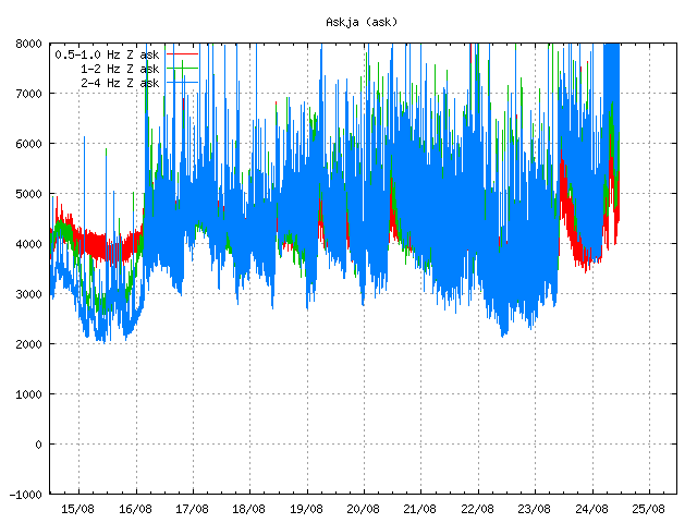
The SIL station in Askja volcano is also showing the massive activity in Bárðarbunga volcano. This is the harmonic tremor at 11:33 UTC. Copyright of this image belongs to Icelandic Met Office.
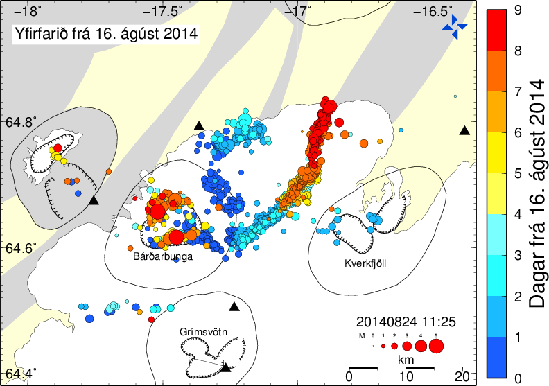
bbbeginman.svd.24.08.2014.at.11.32.utc
Current length of the dyke from Bárðarbunga volcano. Blue dots are the oldest and the red ones are the newest. This shows the earthquakes from 16-August-2014. Copyright of this image belongs to Icelandic Met Office.

The harmonic tremor seems to increase when there is a new flow of magma at depth into the dyke. Large earthquakes happens in Bárðarbunga caldera when it adjust to this flow out of the magma chamber above it. There are clues that magma at depth might have triggered this, but there is a lack of deep earthquakes in Bárðarbunga volcano so it is difficult to say for sure.
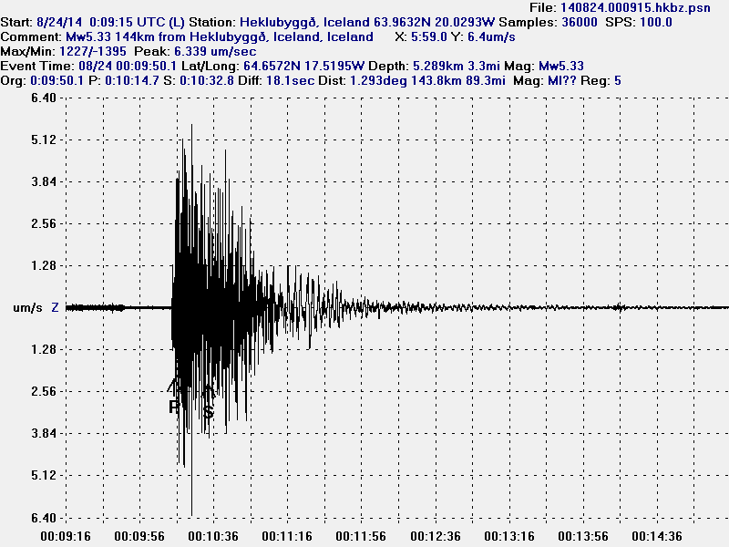
140824.000915.hkbz.psn
This is the magnitude 5,3 earthquake that took place today (24-August-2014) at 00:09 UTC. This is my geophone in Heklubyggð. This image is released under Creative Commons Licence. Please see CC Licence page for more details.
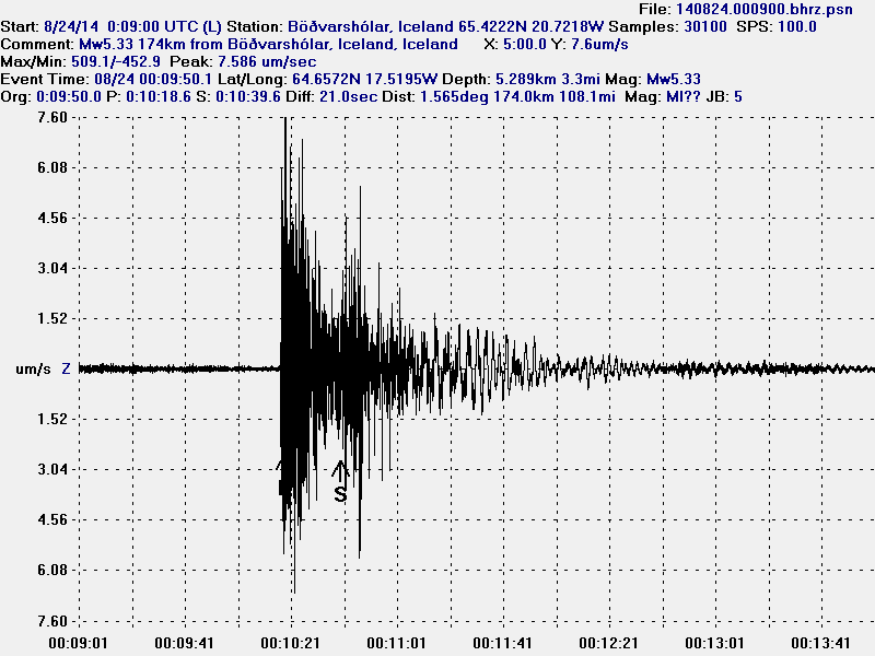
140824.000900.bhrz.psn
This is the magnitude 5,3 earthquake that took place today (24-August-2014) at 00:09 UTC. This is my geophone in Böðvarshólar. This image is released under Creative Commons Licence. Please see CC Licence page for more details.
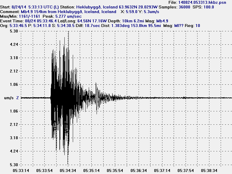
140824.053313.hkbz.psn
This is the magnitude 5,1 earthquake that took place today (24-August-2014) at 05:33 UTC. I use data from EMSC that explains different magnitude in the image. This is my geophone in Heklubyggð. This image is released under Creative Commons Licence. Please see CC Licence page for more details.
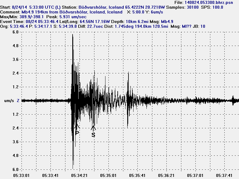
140824.053300.bhrz.psn
This is the magnitude 5,1 earthquake that took place today (24-August-2014) at 05:33 UTC. I use data from EMSC that explains different magnitude in the image. This is my geophone in Heklubyggð. This image is released under Creative Commons Licence. Please see CC Licence page for more details.

As explained above the earthquake activity is dense under Dyngjujökull at the moment. The dyke is also now in part on glacier free area, so if any minor eruptions happen they can be seen on the surface. The dyke seems to be under high pressure, but I don’t know yet if that is going to result in an eruption. But I find it highly likely at this point and given current data.

My geophones can be seen here. Some of the activity that is now taking place in Bárðarbunga appears on them. Larger earthquakes (magnitude 3,5 and above) appear always at this distance. Wind appears on my geophones if weather is bad in Iceland.

Updated at 14:12 UTC.

Smallest of eruptions so far (Bárðarbunga update at 20:43 UTC)

This is a short update and this information might go outdated quickly.

It appears that the eruption that took place in Bárðarbunga volcano was a minor one. It also looks like that the eruption was so small that it didn’t even make dent in the glacier on top of it, but the glacier in this area is around 400 meters thick. Such minor eruptions are not common in Iceland, but they do happen once in a while.

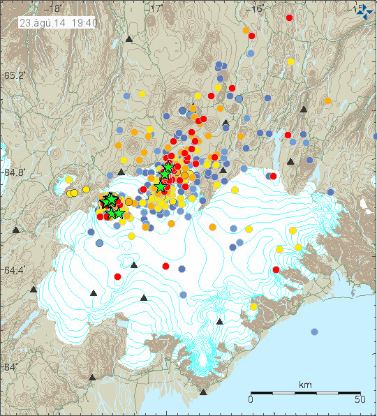
140823_1940
Earthquake activity today (23-August-2014) in Bárðarbunga volcano. Copyright of this image belongs to Icelandic Met Office.

Largest earthquake today had the magnitude of 4,5 (EMSC information here) – 4,7 (USGS). Other earthquakes that have taken place today have been smallers, few earthquakes with magnitude above 3,0 also took place today.

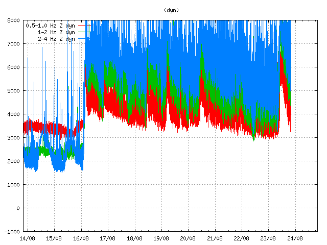
dyn.svd.23.08.2014.at.19.59.utc
The harmonic tremor that took place in Bárðarbunga volcano today. It makes a clear mark from the other magma movement that has been taking place during the past week. This is Dyngjuháls SIL station. Copyright of this image belongs to Icelandic Met Office.

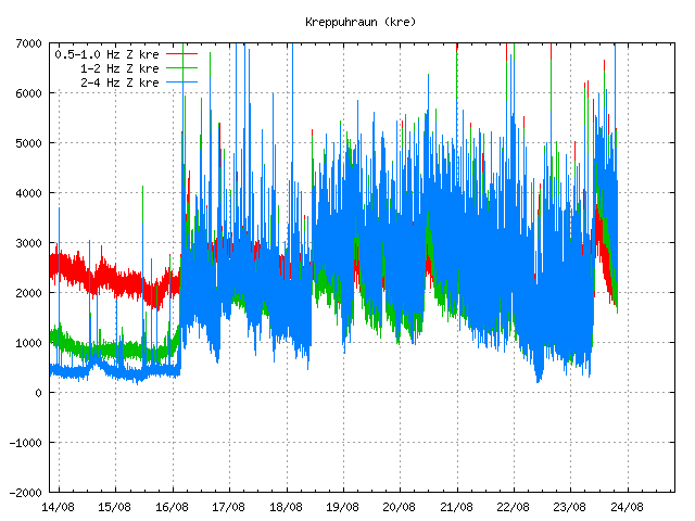
kre.svd.23.08.2014.at.20.00.utc
This harmonic tremor was also visible on Kreppuhraun SIL stations. Copyright of this image belongs to Icelandic Met Office.

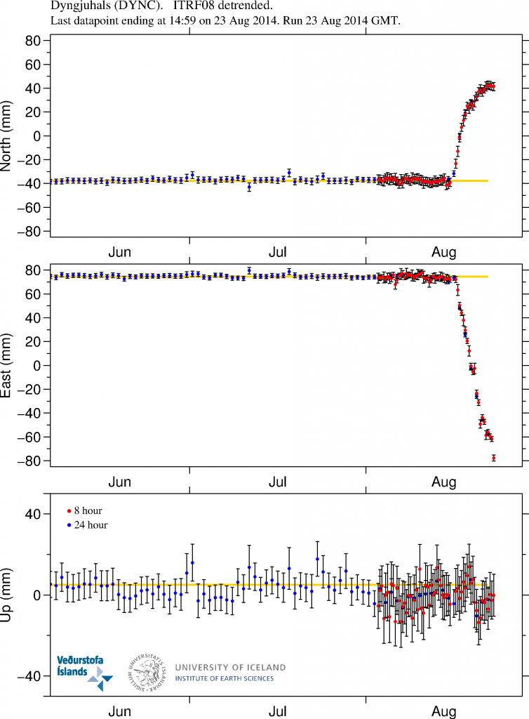
DYNC_3mrap.svd.23.08.2014.at.19.00.utc
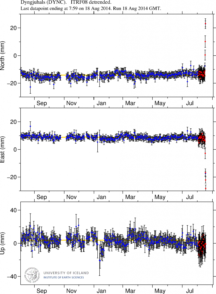
GPS data showing current inflation on Dyngjuhjáls. More plots can be found here. Copyright of this image belongs to University of Iceland.

Current GPS data show that inflation to the north has stopped, while inflation to the west has increased and up to 2 to 3 cm a day based on newest GPS data. This means that more magma is flowing into the dyke on 5 to 10 km depth. The dyke continues to extent, but now it is moving more north rather then north-east as before.

The eruption that took place today was a minor one. I am not even sure it lasted a whole hour, but since it was under a 400 meter thick glacier that is only guess work on my end based on tremor data that I have. This might however not be the last eruption in Bárðarbunga volcano, far from it. Short eruptions like this one might happen on regular basis now in Bárðarbunga volcano and not all of them are going to take place under glacier in my view.

Update on Bárðarbunga volcano at 14:37 UTC

This is a short update on Bárðarbunga volcano activity.

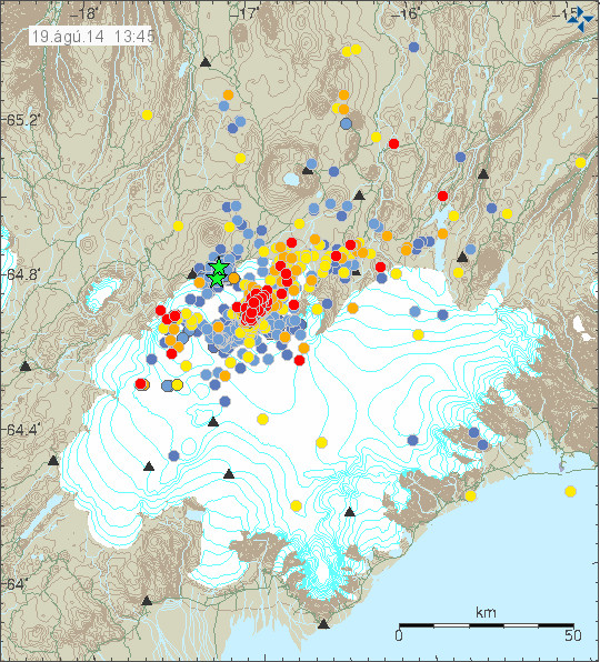
Little has changed since yesterday (18-August-2014) in Bárðarbunga volcano. Earthquake activity has been moving east and north-east since yesterday but continues at same rate as before. It is not clear why that is, but is getting close to Kverkfjöll volcano, but at the moment the earthquake swarm is inside a fissure swarm that belongs to Bárðarbunga volcano. I do not know what happens if magma from Bárðarbunga volcano gets into contact with magma in Kverkfjöll volcano.

140819_1345
Earthquake activity in Bárðarbunga volcano during the past 48 hours. During the past 24 hours (when this is written) no earthquake has had magnitude above 3,0. Copyright of image belongs to Icelandic Met Office.

140819_1345_trace
Earthquake activity remains heavy in Bárðarbunga volcano. Copyright of image belongs to Icelandic Met Office.

No major earthquake has taken place during the past 24 hours (when this is written). This means that no earthquake so far has reached the magnitude above 3,0.

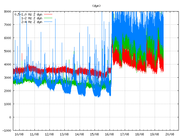
dyn.svd.19.08.2014.at.13.52.utc
Harmonic tremor remains high in Bárðarbunga volcano, even if there is no eruption taking place at the moment. Copyright of image belongs to Icelandic Met Office.

The harmonic tremor clearly shows the pulse activity that is taking place in Bárðarbunga volcano, when the earthquake activity drops, so does the tremor. When the harmonic tremor increases, earthquake activity increases soon after it. Sometimes earthquake activity increases before an increase in the harmonic tremor takes place.

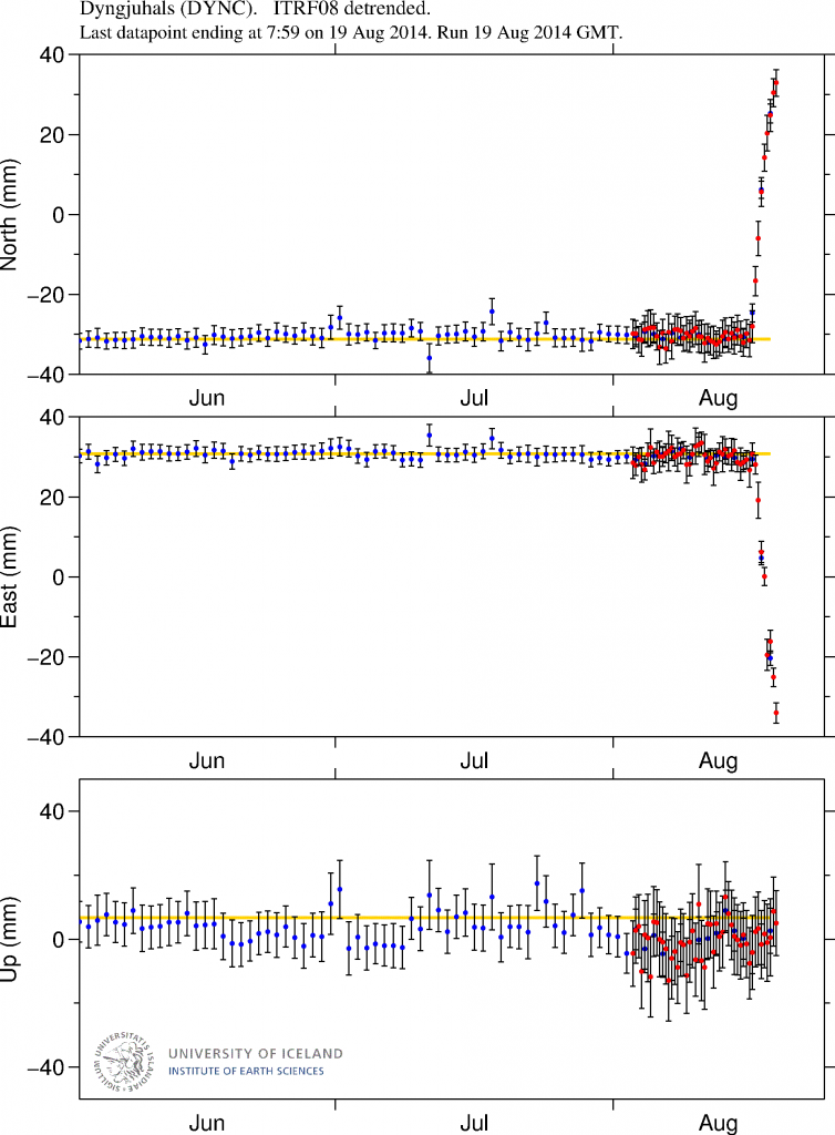
DYNC_3mrap.svd.strokkur.raunvis.hi.is.svd.19.08.2014.at.13.06.utc
GPS data from University of Iceland clearly shows the amount of magma that is flowing into Bárðarbunga volcano system at the moment. More plots can be found here. Copyright of this image belongs to University of Iceland.

The GPS data shows how fast this inflation now is. This data is just for few days. I am expecting more inflation to take place in the next few days. How much inflation is needed before an eruption starts I do not know.

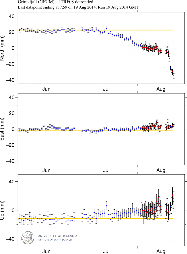
GFUM_3mrap.strokkur.raunvis.hi.is.svd.19.08.2014.at.13.34.utc
Same pattern of change can be seen in GPS data on Grímsfjall volcano. More plots can be found here. Copyright of this image belongs to University of Iceland.

There are no signs of this activity stopping. When this is going to results in an eruption I do not know. For people looking for web cameras of Bárðarbunga volcano, a new web camera has now been set-up by Míla communication company in Iceland. It sends out live from Bárðarbunga volcano (as close they can get to it). The web camera can be viewed here.

Orange alert level declared for Bárðarbunga volcano

This is short update on Bárðarbunga volcano. Due to ever changing nature of this events this information is going to get outdated quickly.

Icelandic Met Office has moved the warning level for air traffic up to Orange level (see here). GPS measurement have confirmed magma movements inside Bárðarbunga volcano and this movement is fast.

DYNC_rap.svd.18.08.2014.at.15.13.utc.raunvis.hi.is
GPS data from University of Iceland. This data shows how fast the change has been in the past few days. More GPS data can be found here. Copyright of this image belongs to University of Iceland.

Earthquake activity has remained about the same, with regular fluctuation in activity. Overall however the activity has remained constant.

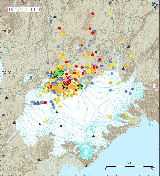
140818_1440
The earthquake activity in Bárðarbunga volcano. Copyright of this image belongs to Icelandic Met Office.

The earthquake activity in Bárðarbunga volcano has been migrating to the north-east over the past 10 to 18 hours. The activity close to Dyngjuháls appears to be stable at that location for the moment. Earthquake activity in other parts of Bárðarbunga have quieted down for the moment, that might change without warning.

140818_1440_trace
Earthquake activity has remained stable in Bárðarbunga volcano. Copyright of this image belongs to Icelandic Met Office.

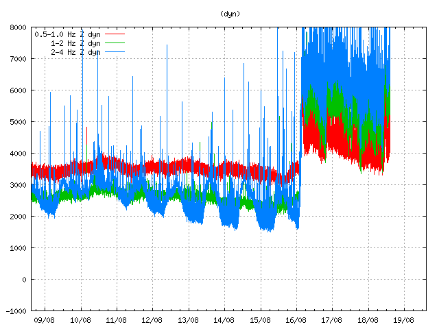
Harmonic tremor levels have remained stable since this started. They do drop a little in sync with the drop in earthquake activity.

dyn.svd.18.08.2014.at.14.46.utc
The harmonic tremor at Dyngjuháls SIL station. Copyright of this image belongs to Icelandic Met Office.

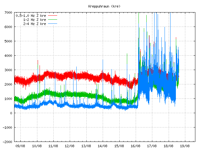
kre.svd.18.08.2014.at.14.47.utc
Kreppuhaun SIL station shows the harmonic tremor also. Along with interesting jump in the past hour of harmonic tremor activity. I am not sure why that is. Copyright of this image belongs to Icelandic Met Office.

von.svd.18.08.2014.at.14.46.utc
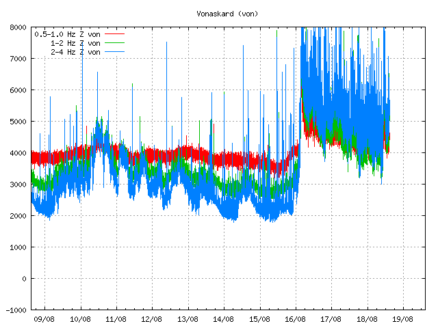
Vonaskarð SIL stations shows pattern that is close to what appears on Kreppuhraun SIL station. Copyright of this image belongs to Icelandic Met Office.

I am not sure why the harmonic tremor levels are what they are at the moment. Since no eruption has started. This might be due to changes in hydro-thermal areas under the glacier, or there might be some other reason for this that is not known to me.

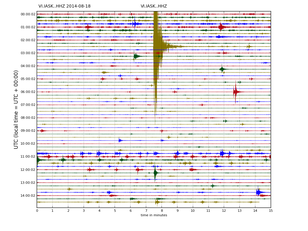
IASK.svd.18.08.2014.at.14.46.utc
Drum plot that Icelandic Met Office has on-line are showing interesting activity. Around 11:00 UTC there is a string of earthquakes, following this activity a increase in harmonic tremor takes place. Copyright of this image belongs to Icelandic Met Office.

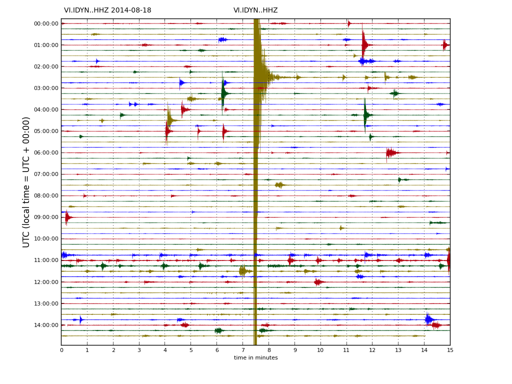
IDYN.svd.18.08.2014.at14.46.utc
This can also be seen on Dyngjuháls SIL station. Copyright of this image belongs to Icelandic Met Office.

IKRE.svd.18.08.2014.at.14.48.utc
This also appears clearly on Kreppuhraun SIL station. Copyright of this image belongs to Icelandic Met Office.

As for amount of earthquake detected today, so far the amount recorded today is around the same as yesterday, might even be slightly higher.

Updated at 16:43 UTC.

More magma in Hekla magma chamber then before 2000 eruption

According to news today on mbl.is there is now more magma in Hekla volcano then before the 2000 eruption. The news says that since the year 2006 there has been more magma in Hekla magma chamber then before the last eruption in the year 2000. This has not meant an eruption so far. Hekla volcano magma chamber have the depth of around 10 to 20 km. This means this inflation that is now taking place does not appear clearly on the surface, but changes are being measured by GPS system that Icelandic Meteorological Office has. This is also appearing on GPS instruments that geological department University of Iceland has. Even if inflation is now more in Hekla volcano then during the eruptions in the year 1991 and 2000 it does not mean that next eruption is going to be bigger. Since the size of the eruption depends on how much of the magma is mobile in the magma chamber. That amount remains unknown until eruption takes place and even then not all of the mobile magma might erupt.

It is also pointed out in the news that it is risky to go on top of Hekla volcano as is. At least while no eruption has taken place currently. Since the risk of eruption is in place and the time from magma starts to move and until eruption takes place is short. Often less then 1 hour. It is advised in this news that people should not go on top of Hekla volcano. The risk is that eruption starts and trap people on top of the volcano, with deadly consequences.

It is possible to read the Icelandic news here. Please use Google Translate with care. It’s not always correct.

Kvikusöfnun meiri í Heklu en árið 2000 (mbl.is)

Donation notice: Please remember to donate and support my work (I am having one of the bad and awful months now). Thanks!

Earthquake activity drops in El Hierro volcano

Earthquake activity in El Hierro volcano has started to drop off again. During the last 24 hour period there have only been something around 28 earthquakes. But earthquake activity did peak with 182 earthquakes during 24 hour period on Sunday 16. September 2012.


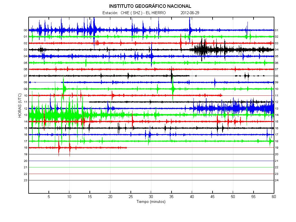
The earthquake activity in El Hierro volcano at 19:22 UTC. As can be seen here. Everything is quiet for now.Copyright of this image belongs to IGN.

It is hard to say what happens next in El Hierro volcano. But magma is still getting injected into El Hierro volcano at depth. Eruption is still an possibility while inflation continues at the rate it is going. There is always the chance that deflation is going to start in El Hierro volcano. Chance of an eruption in El Hierro volcano remains high. But when it might start it impossible to say at this point.

Update on El Hierro volcano activity

This is a short update on the activity in El Hierro volcano.

In the last 24 hours there have been no major changes in the activity of El Hierro volcano. No eruption has started yet. But earthquake activity continues with the same rate as in past few days. Magnitude of the earthquakes that are currently taking place is around ML1.5 to ML3.5, with the focal depth of around 20 km. But deepest earthquakes have the depth of around 28 km. While the shallowest earthquakes have the depth around 15 to 12 km. No harmonic tremor is currently taking place in El Hierro volcano. According to GPS data from El Hierro volcano. There is inflation taking place at the current moment. That means magma is injecting it self into the volcano at the depth of 20 km. There is already older magma from last year magma injection. Some of that magma erupted last year, but not nearly all of it. I do not know what happens if the new magma gets into contact with older magma that is in El Hierro volcano. There is also possibility that older magma from eruptions that took place thousands years ago is still in El Hierro volcano. That magma might be andesitic to rhyolitic in nature. If that is the case is impossible to know for sure. But this is always an risk with any volcano, regardless where they are located in the world.


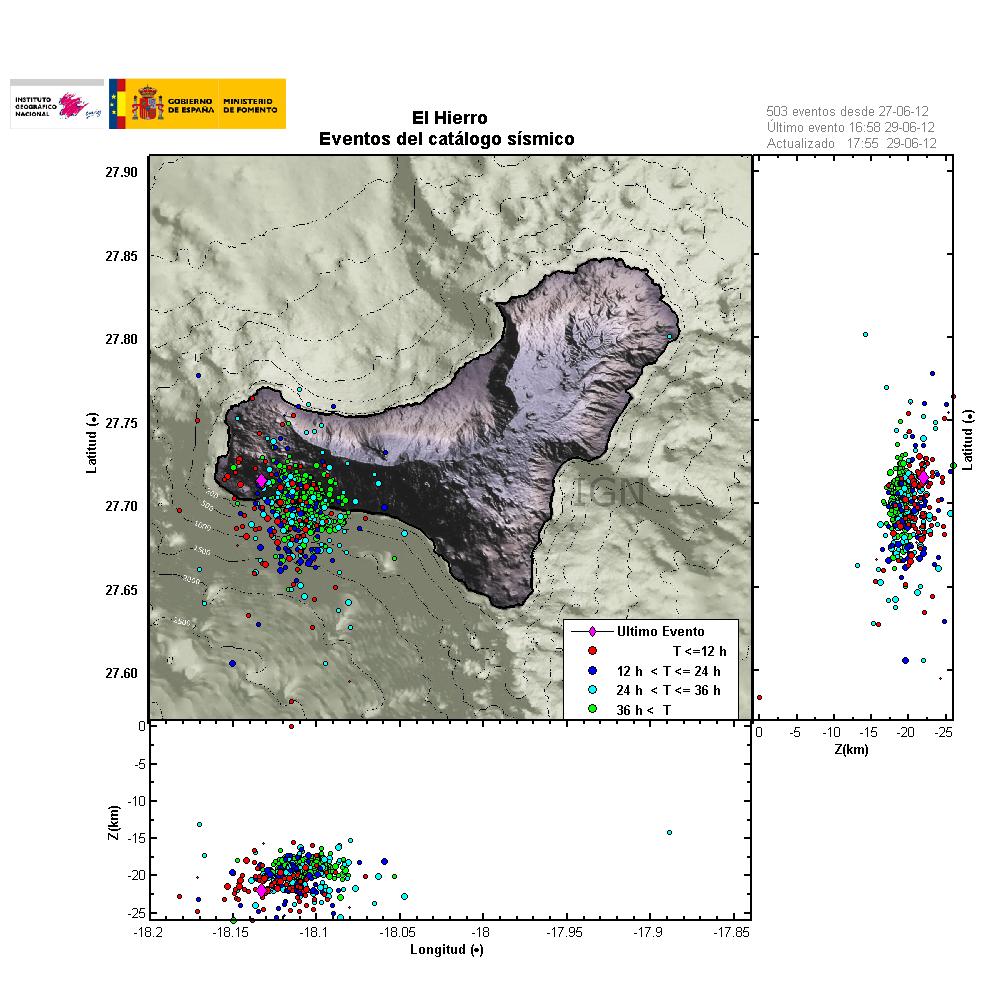
Earthquake activity in El Hierro volcano during last four days. Copyright of this image belongs to IGN.


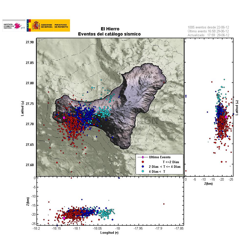
Earthquake activity during one week in El Hierro volcano. This map clearly shows the extent of the magma during this past week. Copyright of this image belongs to IGN.


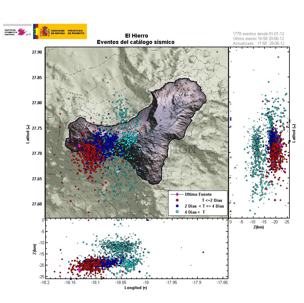
Earthquake activity since 1. January 2012 in El Hierro volcano. Copyright of this image belongs to IGN.


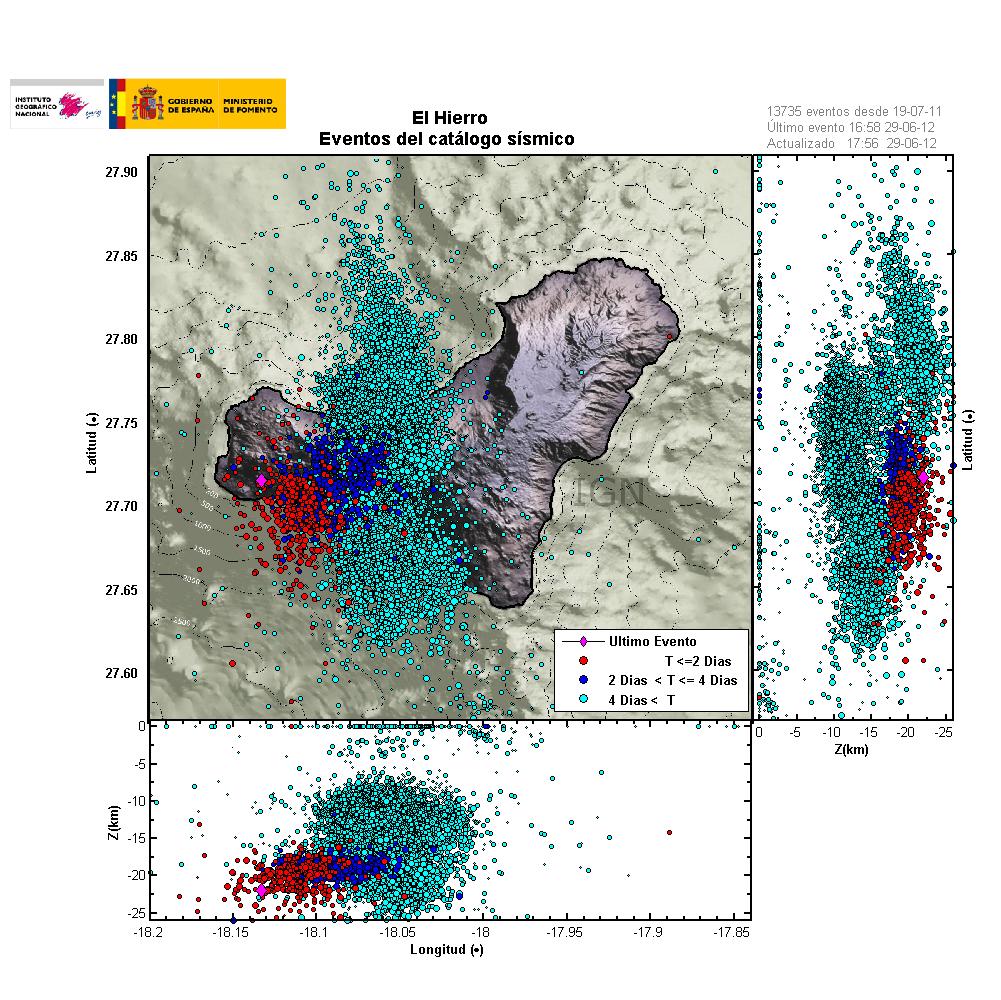
Total amount of earthquakes in El Hierro volcano since activity started last year. Copyright of this image belongs to IGN.


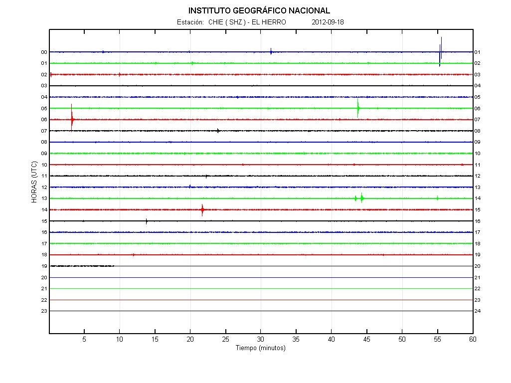
Current earthquake activity in El Hierro volcano. No harmonic tremor is currently being detected in El Hierro volcano. Copyright of this image belongs to IGN.

It is difficult to day what happens next in El Hierro volcano. But I do believe that current earthquake activity is going to continue for the next few days to weeks. That activity depends on how much magma flows into El Hierro volcano. That flow might not be constant all the time. So there is going to be period of time with low activity during current events. When this is written, total of around 130 earthquakes have taken place in El Hierro volcano today (29. June 2012) so far.

Known eruptions in El Hierro volcano

Year 4790 BC (Radiocarbon)
Year 950 BC (+- 150 years)
Year 550 BC (+- 75 years)
Year 1677 (Uncertain eruption. Not confirmed.)
Year 1692 (Uncertain eruption. Not confirmed.)
Year 1793 May to 1793 June. Erupted on NW rift, GVP says that the eruption may have taken place at Volcán de Lomo Negro (?). But that is not confirmed or established at current time.
Year 2011 September to December, off the coast. Not on GVP web page.

Source: GVP web page, Hierro

Blog post updated at 20:16 UTC on 29.06.2012.

Analyze on events in El Hierro volcano

This is a short analyze of what is happening in El Hierro volcano. What is taking place in El Hierro volcano has an simple explanation. What is taking place in El Hierro volcano is an dike intrusion. This creates earthquakes as new magma is injected into the crust. This is also creating inflation on the surface. It has been reported so far the inflation is 20mm up, 20mm east, 20mm north. This can clearly be seen on GPS data that was released today.


The inflation according to IGN. This is recent GPS data. Copyright of this image belongs to ING/AVCAN

The dike intrusion into El Hierro volcano is creating sill in it. While new magma is being injected into the volcano. It is going to mean earthquake activity and a lot of it. Currently there are three older sill that have formed in El Hierro volcano. This sill clearly appear on images that show the earthquake pattern over the past one year in El Hierro volcano.


Earthquake activity marks the sill and older magma injection areas in El Hierro volcano. Copyright of this image belongs to ING/AVCAN


Earthquake activity in El Hierro volcano as it is today. This is accumulated earthquake activity sine current earthquake swarm started. Copyright of this image belongs to ING/AVCAN

What happens if the new injection gets into contact with the old inection is anyone guess. But new magma, if it gets in contact with an older magma might mobilize it. It might not mean an eruption. But earthquake activity might get really intense for a while. A lot more intense then it already is today. With earthquake well above magnitude ML3.0 and up to ML5.0 (depending on the stress of the crust in the area).


Earthquake activity in El Hierro volcano today. So far no harmonic tremors have been detected. But that might change without warning if the magma finds a path to the surface. Copyright of this image belongs to ING/AVCAN

When I write this I see that El Hierro volcano has had it first ML4.0 earthquake as I did fear yesterday might happen. But I made a comment on that on AVCAN Facebook page yesterday (Somewhere, I have no idea where it is located).

References:

Dike (geology) (Wiki)
Sill (geology)
Intrusion triggering of the 2010 Eyjafjallajökull explosive eruption (http://geoscience.wisc.edu/)

Krísuvík volcano inflates and deflates regularly

It seems that Krísuvík volcano is inflating and deflating on regular basic. I do not know how regular this change is. But it has been noticed by Icelandic scientists how are bit puzzled by this behavior. Last inflation episode did last until end of the year 2011. Since then deflation did start again and is currently ongoing. It is uncertain if what this means. At the moment it is too early to know for sure if this means if that Krísuvík volcano is getting ready for an eruption. But if there was an eruption in Krísuvík volcano, it would be Hawaiian eruption so no volcano ash. Volcano ash eruption would only take place if an eruption started in Kleifarvatn lake. But the effects of that would be limited to local area (Reykjavík and other nearby towns). It would not create any global problems, as many would want to believe.

Inflation and deflation period have been the years 2009, from January to September. In May 2010 inflation did start again, that inflation period lasted until end of the year 2011. Since then deflation has been taking place. Today there is continues GPS monitoring in Krísuvík volcano. But it is unknown if this type of behavior has taken place before in Krísuvík volcano. But for now Krísuvík volcano is being monitored both with GPS and the SIL network. What happens next anyone guess.

Icelandic news about this.

Land rís og sígur í Krýsuvík (Rúv.is)