
This information is going to get outdated quickly.
This is the short update on status on the activity in Bárðarbungu volcano.
- Current activity is mostly unchanged. Earthquake activity remains high and there are around 1000 earthquakes every 24 hours.
- According to the news today and Icelandic Met Office data, the dyke doesn’t appear to be getting longer. It is now around 37 km long.
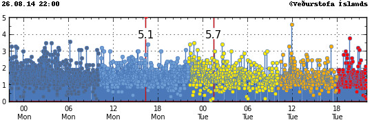
- Largest earthquake since 2008 took place in Bárðarbunga volcano on 26-August-2014 at 01:26 UTC. It had the magnitude of 5,7 and took place in Bárðarbunga caldera. Second medium earthquake took place today at 11:56 UTC and had the magnitude 4,6. It was felt in Akureyri.
- There are no signs of magma going to the surface as of writing of this article. I do expect that change quickly.
- It is now my view that after the magnitude 5,7 earthquake the risk of an eruption Bárðarbungu caldera has increased from what it was. I don’t know yet if an such eruption is going to take place. I however find it to be the most likely outcome based on current status.
The magnitude 5,7 earthquake that took place on 26-August-2014 is the strong earthquake in Iceland since 2008, when a magnitude 6,3 earthquake happened between Selfoss town and Hveragerði in the South Seismic Zone in Iceland (often just called SISZ). Earthquake activity remains high in the north end of the dyke, with strongest earthquake today having the magnitude 4,6. With many more magnitude 3,0 and stronger earthquakes taking place. There are still over 1000 earthquakes being recorded every 24 hours in area where the dyke is located (about 20 km east of Trölladyngja).
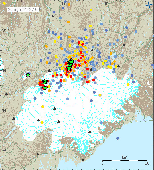
Earthquake activity in Bárðarbunga volcano today. This map is already outdated. Copyright of this image belongs to Icelandic Met Office.
Earthquake activity remains extremely dense in the dyke from Bárðarbunga volcano. Copyright of this image belongs to Icelandic Met Office.
Total lack of earthquake at the start of the dyke suggest that the flow of magma is now smooth and it is flowing without any resistance to the north end of dyke. Where the dyke seems to have hit a resistance in the crust that he is not able to break at current time. I don’t know if the earthquakes that have been taking place today are going to change that. But if this resistance in the crust holds there is a chance it there are going to be even large earthquakes that are going to take place at this location. What magnitude is to expect is difficult to know for sure, but the crust in this area is able to make earthquakes above magnitude 5,5, but how far up the scale it goes I do not know.
There has been some deep earthquake activity taking place according to the automatic data, but since it is automatic data it might be wrong. The deepest earthquake that I did see to day took place today had a automatic depth of 29,3 km with quality of 90,10. There is a chance this dyke might get into connection of other deep dyke in this area. This are dykes that form deep in the crust at depth of more then 30 km, they don’t make any earthquakes when they form since the crust material in this region of the crust is soft and is unable to break and does not make an earthquake as result. I do not know what happens if this dyke manages to connect to an dyke that might have formed in the deeper range of the earth crust in this area. It is also a highly unlikely outcome, for the moment however it is not impossible. Since the dyke now has problems pushing north, and as an result of that it seems to be pushing a little bit down as result. It is clear that once it can not extent any future down or to the sides, it is going to go up. I am not expecting the flow of magma into the dyke to drop any time soon. That might happen, it is just unlikely to happen given the current data. Estimated amount of magma is around 350 million m³ today (26-August-2014).
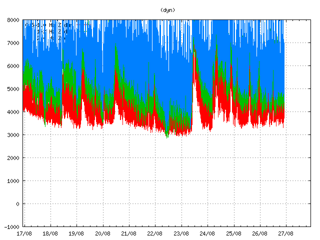
Harmonic tremor remained high in Bárðarbunga volcano due to magma flow in the dyke. This is Dyngjuháls SIL station. Copyright of this image belongs to Icelandic Met Office.
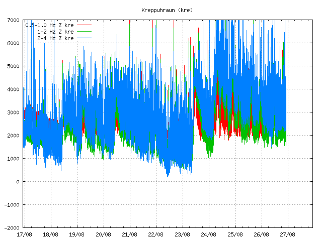
Here is the harmonic tremor in Bárðarbunga on the SIL station in Kreppuhraun. Copyright of this image belongs to Icelandic Met Office.
The harmonic tremor shows that the dyke inflow continues as I did write about above. It also shows one important thing, the flow of magma into the dyke and presumably into Bárðarbunga volcano is not even. It happens in short periods of high inflow with lower periods between them.
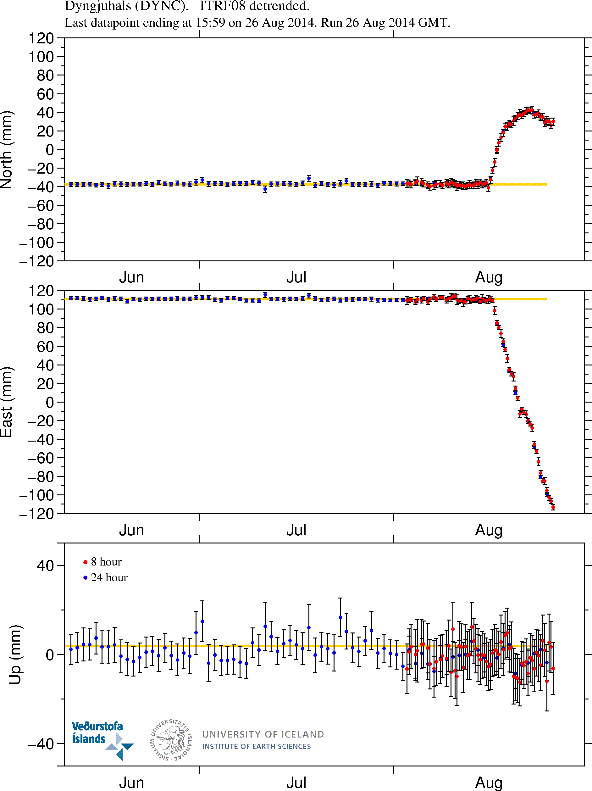
GPS data show the magma continues to flow into the dyke at 5 to 10 km depth. More GPS plots can be found here. Copyright of this image belongs to University of Iceland.
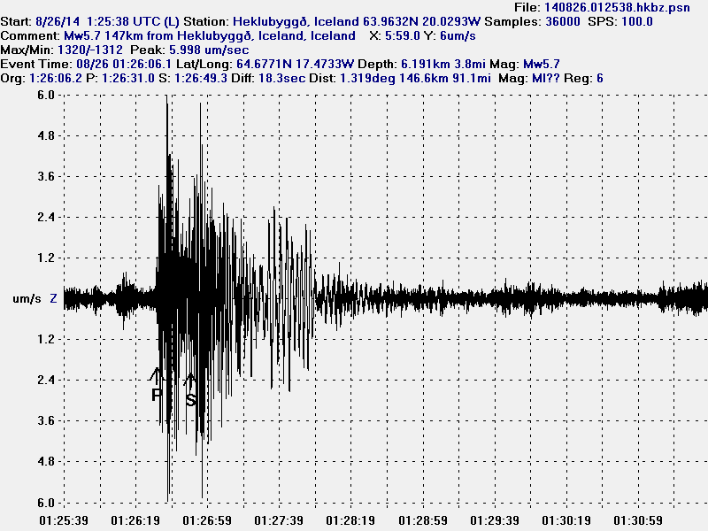
The magnitude 5,7 earthquake as it appeared on my geophone in Heklubyggð. This image is released under Creative Commons licence. See CC Licence page for more details.
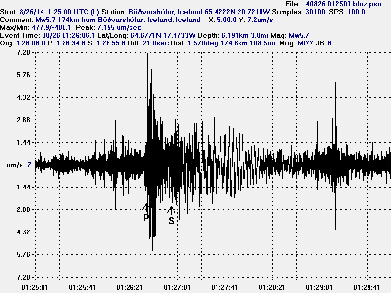
The magnitude 5,7 earthquake as it appeared on my geophone in Böðvarshólar. This image is released under Creative Commons licence. See CC Licence page for more details.
What this has told me is that there is far more magma in Bárðarbunga volcano then appear at first sight. How much of it can actually erupt in an eruption I do not know. But this seems to be far more complicated then I first thought, it is not just a dyke pushing out of Bárðarbunga volcano. There is also a lot more magma inside the magma chamber that is starting to look for an way out, at least from the looks of current activity. The glacier inside the caldera is 700 meters thick so the magma inside the magma chamber that is directly below the caldera is under this extra pressure from the glacier. Once that magma overcomes the pressure of the glacier an eruption is going to start in the caldera, until that time we might see more dyke activity going north and south of Bárðarbunga volcano. Since the magma is going to go first the easiest way out. How much pressure has to be inside the magma chamber to overcome the pressure of the 700 meter thick glacier inside the caldera I do not know. All I know is that it is a high number on any pressure scale.
As of this writing a new magnitude 5,1 (more on EMSC website here) has taken place in Bárðarbunga volcano caldera. Larger earthquake appear clearly on my geophones that can be viewed here.
Hey. I’m still following you here :-).
There was a new big earthquake of 5.2 in richers scale one hour ago or so (00:16:28) in the Bárðarbunga volcano.
http://earthquake.usgs.gov/earthquakes/eventpage/usc000s7al#summary
I suspect the pressure increase due to the glacier is often overstated. After all some 600 metres of ice creates a similar static pressure as some 250 metres of soil (density difference, give or take a bit).
One should also keep in mind that ice and water can be quite effective in “smothering out” an eruption when the supply of water is sufficient. Think of table mountains (or the el Hierro eruption). Water is a very efficient coolant and it can effectively also condense many gases. Even CO2 could be condensable at the bottom of glacier… for a while.
When water supply is more limited than magma supply, one may get a lot more trouble… How many km³ of water/ice is there within the Bárðarbunga caldera?
The best part is that for those million of cubic meters of water: to defrost a liter of water you have to provide the same amount of energy (calories)that you need to take a liter of water from 2*C to near 80*C. I that to defrost and evaporate all the ice in the caldera it’s gonna take several billions calories.
CHECK LOCATION ON THIS ONE, LOOKS LIKES IT’S ON THE MOVE;
http://www.emsc-csem.org/Earthquake/
2014-08-27 01:52:02.425min ago
65.03
N
16.99
W
2
4.2
ICELAND
JUST HAPPENED, QUAKES ALL OVER THE PLACE:
http://www.emsc-csem.org/Earthquake/
Magnitude
M 5.2
Region
ICELAND
Date time
2014-08-27 02:50:44.0 UTC
Location
64.67 N ; 16.42 W
Depth
10 km
Distances
271 km E of Reykjavík, Iceland / pop: 113,906 / local time: 02:50:44.0 2014-08-27
116 km SW of Egilsstaðir, Iceland / pop: 2,265 / local time: 02:50:44.0 2014-08-27
75 km NW of Höfn, Iceland / pop: 1,695 / local time: 02:50:44.0 2014-08-27
This might be the scenario Jón spoke about before. The extending dike strikes an older, solidified granite structure and can no longer advance. I would seriously look for any inflation in the areas that had earlier subsided.
USGS, SAID LAST QUAKE, 5.6
M5.6 – 100km WNW of Hofn, Iceland 2014-08-27 02:50:39 UTC
EMSC SAID: 5.0
http://baering.github.io/
Thought I´d point this out – In case someone had not seen this site.
If its accurate (directly linked to IMO) then pretty big quakes are happening around Askja at the moment. This is probably a new developement. Quiestion is, if this is accurate, is Askja waking up?
Quakes getting bigger in the dyke( 5.0+), and a 4.0+ up by Askja. Dyke making its way up there maybe? This should be very interesting.
There might be another thing to consider, too. Considering all of the tremor, imagine the magma being like a bottle of soda. What happens when you shake it? I am wondering if all that shaking might be causing additional de-gassing of the magma. Might also cause additional fracturing of rock that might already be nearly on the edge of fracturing anyway. All this tremor and shaking from the larger quakes might cause some instability in the surrounding area.
I find it amazing that all three earthquakes sites had different mag. for these three quakes. I watch earthquakes and really not volcanoes. I find this really interesting, the 4.2 hit high and then the next quake was down sound again, like it hit something then rebounded back. I have a feeling, that’s not good right. Thank you Jon for all you do, and for the people on this site also.
http://www.emsc-csem.org/Earthquake/
http://geofon.gfz-potsdam.de/eqinfo/list.php
http://earthquake.usgs.gov/earthquakes/eventpage/usc000s7bm#summary
was looking at is.vendur map and i think we can now see the dyke tip on Mývatn area now.
red alert soon?
is this invalidate the IMO must plausible scenario?
i guess this can take a few days up to a few weeks. or even 2 months. Its a volcano, it plays poker.
Martin, what map are you looking at?
en.vedur.is/earthquakes-and-volcanism/earthquakes/myvatn/
Askja’s tremor plot is going crazy as well as dyn and kre. I see a big eq on the rim of askja on the map.
True! looks like magma inflow is so close now to the Askja system and caldera that confirms future action will take place there…
I believe events will develop a bit faster now on, and I can’t wait to see…,and what a night! Few over M5 in very key locations all…
quakes moved about 2-5km north since my last post.
the train is on the move again
An observation: earthquakes around Askja are plotted on the Mývatn tab on the IMO website and there appears to be crossover with the earthquakes plotted on the Vatnajökull tab in the ‘time and magnitude of earthquake’ sections of both tabs.
I feel much respect and gratitude for your work Jon and all the devoted attendees here. Frejya ( or is it Odin
.) knows why I’m so interested but nonetheless its enthralling reading!
http://www.visir.is/lengist-um-fjora-kilometra-a-dag/article/2014140829176
This is a very interesting story – Ágúst Guðmundsson, professor @ Royal Halloway (https://www.royalholloway.ac.uk/home.aspx) Thinks the magma is not from Bárðarbunga but straight from the plume, much deeper than Bárðarbunga.
He also says that the amount of magma is probably three times as much than IMO says it is – (IMO says 350 million cubic metres).
What is propelling this magma?
All this talk of it escaping bunga, but the amount is increasing day by day. Surely if it’s under enough pressure to break through soilid rock many kilometres away then the pressure was strong enough to break through a few hundreds meteres of ice.
There must be other factors at play here.
The main factor is: a fluid follows the path of least resistance.
Dyke are formed trough fractures, caused by (old?) seismic activity. These fracture form an initial guide for the magma to follow, then expanding the size of the fracture to a dyke.
Also consider that the material of the crater floor can be dense volcanic granite, when it had cooled slowly and without disturbance. You often see eruptions go sideways when the path upward is obstructed.
Grimsvotn
http://cdn.theatlantic.com/static/infocus/grims052311/s_g01_14485758.jpg
You’re right about the sol analogy – obviously loess. 🙂
A phreatic explosion from a caldera could clear the overburden for 10 km radius if some pesky 700 m deep puddle were to get annoying. That should get air to about 115 thousand feet, and give the stratosphere a bit of a tropical feel. Reading the old paperback ‘Krakatoa’ was eye-opening, as to a juxtaposition of ocean meets caldera. Yes, the ocean sorta won, but not without some memorable objections, and several hundred square kilometers of solid pumice raft, that gave the ocean the ultimate lesson in rock, paper, scissors.
sorry, that reply was meant for the old thread.
https://www.youtube.com/watch?v=dQWzLPyRY8I
Very interesting video of the events in Bárðarbunga
Just a quick question. With all these earthquakes is it possible already to get an accurate image of what is underneath the surface until a certain depth?
I have two etymology-related questions.
1) The Icelandic word for ‘mountain’ is ‘fell’. Is this related to the verb ‘to fall’, ‘fallen’ in German?
2) What has become of the usual Germanic word for ‘a mountain’ – ‘berg’ – in Icelandic? Has it survived in some other meaning? In English it has survived as ‘a burrow’.
Hi
The icelandic word for mountain is “fjall” not “fell” – Fell is a hill more or less, a smaller version of a mountain. Not related to the verb fall.
The word “berg” means rock. Mountains are there fore made of berg. Magma dike is “berggangur” gangur is dike and berg the solid version of magma or lava.
The icelandic word for echo is “bergmál” – since the berg speaks back, mál is language.
thanks
Surface activity showing in webcam again !!!
Looks like hot melt water
http://baering.github.io/
What cam are you looking at??
Jay, the one in this link.
http://baering.github.io/
but I have just taken another look and it has stopped. Large amounts of steam were coming of the river in the middle of the image. Maybe it was a short outburst of hot water. When it is windy you can often see dust clouds produced from ash on the ground, but what I saw was clearly coming from the river.
Maybe the bath is about to overflow.
Looks like a sandstorm for me … and im sure it is.
Anyone know about the place of this bardabunga webcam ?
oh well, it appeared to be coming from the river and spread from the river and off the image on the right. It was a short episode and looked like steam not dust.
I thought the wind was quite calm today
The dust there is really very sensitive. You make pfffff and it goes up…
I was 2011 on the way to Askja in a sandstorm. It was very bad. Inside the caldera it was calm, no wind, but the air was full of dust that crunchs between the teeth and made a strange ligth on a sunny day.
Asja with dust in the air
I think that was a bit of fog, not steam, which can happen any time the water is warmer than the air (the water doesn’t have to be hot).
Its back again, I think I would go with fog to.
I think it’s Vaðalda, SE of Askja.
Geophysists at work for more seismometers:
https://twitter.com/fencingtobba
Thanks for the twitter account with pictures. What a great time for these people!
I have a feeling seeing the dike(dyke) moving and the latest seismic activities, these cams will be interesting to watch. I believe on one cam is exactly showing the area of interest. Anyone agree? Askja in the background?
http://vefmyndavelar.mogt.is/
Yes, in the right webcam from left to right: Askja, Herðubreid, Upptyppingar
The dyke is now very near the caldeira of Askja, the earthquake is now visible in the part of Myvatn…
http://en.vedur.is/earthquakes-and-volcanism/earthquakes/myvatn/
The dyke reached the Aska tommorow evening is the speed continue…
PS : I sorry for my bad english but i speaking only french in “Suisse Romande”. Thank you for your understanding 🙂
The plane of quakes has a more obvious linear NNE trend in it today, appeared more NE until now in 3D projection.
http://www.ruv.is/frett/cannot-rule-out-an-eruption-at-bardarbunga