
This is a short update on Bárðarbunga volcano. Due to the fast change that is now taking place in Bárðarbunga volcano this information is going to get outdated quickly.
- Earthquake activity now is extremely dense. With 3 to 5 earthquakes taking place every second (best estimate that I have made).
- Earthquakes have increased in magnitude.
- General activity appears to have increased in Bárðarbunga volcano. Even if no major eruption has yet taken place.
- There is currently no signs of this activity stopping any time soon.
- The dyke in Bárðarbunga volcano continues to get longer and wider, it is now over 40 km long (I think). Formation of this dyke has slowed due to more difficult crust in the area he is now in (that means more earthquakes).
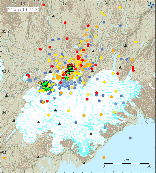
The current earthquake activity in Bárðarbunga. Copyright of this image belongs to Icelandic Met Office.
The extremely dense earthquake activity in Bárðarbunga volcano. Copyright of this image belongs to Icelandic Met Office.
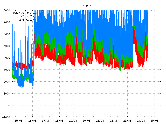
Harmonic tremor is getting off the tremor plot that Icelandic Met Office has on its website. This is the harmonic tremor at 11:33 UTC. This is Dyngjuháls SIL station. It is closest to the dyke at the moment. Copyright of this image belongs to Icelandic Met Office.
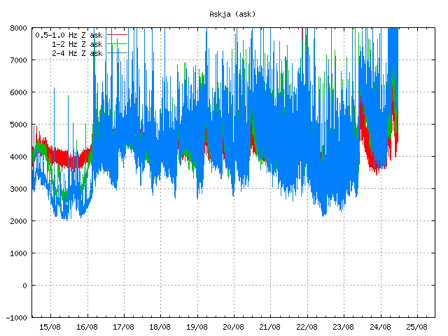
The SIL station in Askja volcano is also showing the massive activity in Bárðarbunga volcano. This is the harmonic tremor at 11:33 UTC. Copyright of this image belongs to Icelandic Met Office.
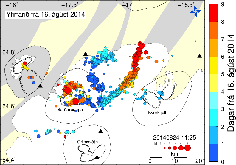
Current length of the dyke from Bárðarbunga volcano. Blue dots are the oldest and the red ones are the newest. This shows the earthquakes from 16-August-2014. Copyright of this image belongs to Icelandic Met Office.
The harmonic tremor seems to increase when there is a new flow of magma at depth into the dyke. Large earthquakes happens in Bárðarbunga caldera when it adjust to this flow out of the magma chamber above it. There are clues that magma at depth might have triggered this, but there is a lack of deep earthquakes in Bárðarbunga volcano so it is difficult to say for sure.

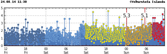
This is the magnitude 5,3 earthquake that took place today (24-August-2014) at 00:09 UTC. This is my geophone in Heklubyggð. This image is released under Creative Commons Licence. Please see CC Licence page for more details.
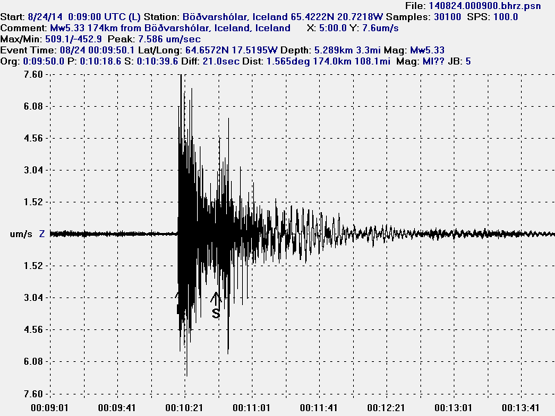
This is the magnitude 5,3 earthquake that took place today (24-August-2014) at 00:09 UTC. This is my geophone in Böðvarshólar. This image is released under Creative Commons Licence. Please see CC Licence page for more details.
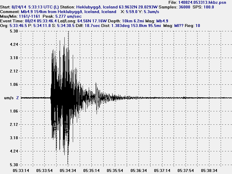
This is the magnitude 5,1 earthquake that took place today (24-August-2014) at 05:33 UTC. I use data from EMSC that explains different magnitude in the image. This is my geophone in Heklubyggð. This image is released under Creative Commons Licence. Please see CC Licence page for more details.
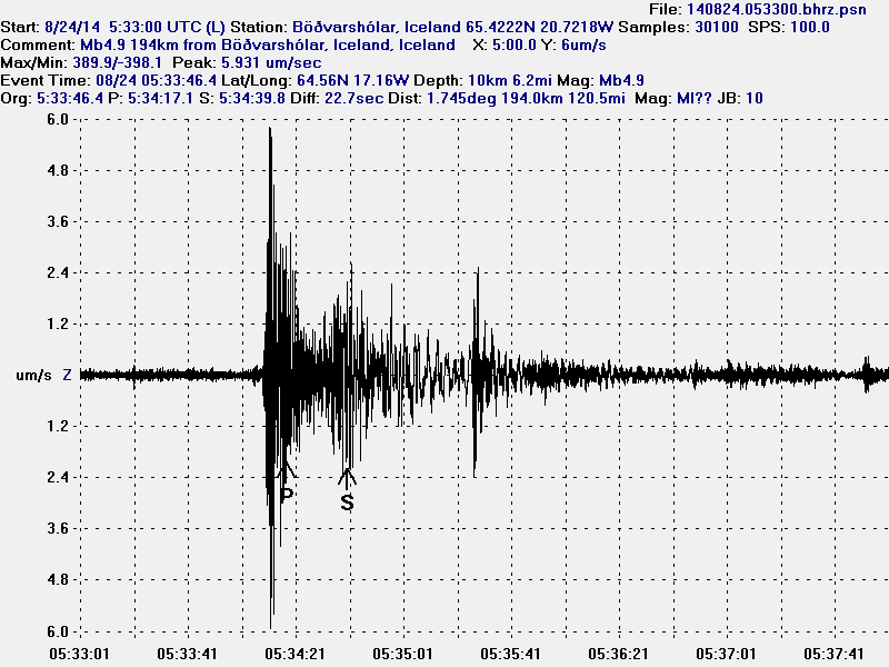
This is the magnitude 5,1 earthquake that took place today (24-August-2014) at 05:33 UTC. I use data from EMSC that explains different magnitude in the image. This is my geophone in Heklubyggð. This image is released under Creative Commons Licence. Please see CC Licence page for more details.
As explained above the earthquake activity is dense under Dyngjujökull at the moment. The dyke is also now in part on glacier free area, so if any minor eruptions happen they can be seen on the surface. The dyke seems to be under high pressure, but I don’t know yet if that is going to result in an eruption. But I find it highly likely at this point and given current data.
My geophones can be seen here. Some of the activity that is now taking place in Bárðarbunga appears on them. Larger earthquakes (magnitude 3,5 and above) appear always at this distance. Wind appears on my geophones if weather is bad in Iceland.
Updated at 14:12 UTC.
All those earthquakes may be the sound of Iceland’s trouser zipper as it goes out to take a leak.
Do you accept the mantle plume idea? Something has to be feeding this and sustaining the heat in the magma for this level of fluidity.
It’s not that long since we had a tidal wave in askja, it sounded daft to start with, but is askja going to be involved, it has been heating up since last year, and that why IMO increased monitoring it.
When you look at the north atlantic picture
http://en.vedur.is/earthquakes-and-volcanism/earthquakes/atlantic/
it looks like everything over a wide radius is focusing on Vatnajökull like a big boil.
I think the IMO should be putting extra sensory equipment into more remote currently unmonitored areas to keep a weather eye on the rear view mirror just in case.
There is no need at all to consider the heat source. There is melt, it is hot, it is voluminous to an extent unseen.
When you open the crust fast to depth it creates intense decompression melting and its rise. What’s solid hot rock under high confining pressure turns partially to liquid. No further heating needed.
Carl at Volcano Cafe has a post up today that says it all far better than I could and provides the actual context. No point rehashing the same story with different words.
All we need to know is accelerating crustal hinging and apparent decompression melting is apparently happening before our eyes.
And note the lack of mag 6 or mag 7 so far, this is tension-driven, not transient impulse punches.
So, in laymans terms, what does all this mean? In reading a CNN new article, it says the aviation alert level was dropped to orange and that scientists state that currently there is no volcanic activity and that there was not an eruption as previous thought. The article almost sounds like “the coast is all clear”, nothing to see here, nothing to worry about anymore. I read somewhere that the UK MET complained about the red alert as it was affecting confidence in many areas such as travel. So, what is happening in this volcano. Is it cooling down now ? (IMO says no more tremors) and an eruption no longer appears immanent?
The meaning of the Orange alert is explicitly defined in the legend on their Aviation alert page, didn’t you read it? It says:
“ORANGE: Volcano shows heightened or escalating unrest with increased potential of eruption.”
“Heightened” and “increased potential” is what IMO are saying.
As for your assertion, “… (IMO says no more tremors) …”, that could not be any more inaccurate. The IMO website is overflowing with thousands upon thousands of earthquakes occurring, up to this minute, with no sigh at all of them easing. Instead they are intensifying at a rate and for a duration that’s never been seen before, and the observed activity has been steadily accelerating each day for 9 days straight.
It is a lot higher now than it was than two days ago, when they thought the activity was surging so much an eruption was probably occurring.
How you came to this conclusion IMO are saying its all over is indifferent to the observed facts.
The potential for a much larger eruptive sequence is being openly discussed at this time, both at IMO, at the seismic oriented site you are now reading, and a detailed discussion of the rapidly developing large eruption volcanology options are on-going in this page right now:
http://volcanocafe.wordpress.com/2014/08/24/bardarbunga-nature-of-the-beast/
Yes carls data is good. Seems to be heading for askja.
When IMO say there is no tremor they are referring to tremor less than 1Hz. That is what they look at for eruption evidence. I guess they think people don’t understand what they are on about a yay so why bother be more specific
Tungafellsjökull has shown small signs of awakening for over a year. Time will tell.
One of the last times a went to Iceland (a few years ago now) i was told that Tungafellsjökull was presumed dead!
Mind you humans have been caught out that way before…
There seems to be widespread quakes around Askja, and the dike is still moving towards it. Any idea when it reaches the Askja magma chamber? Askja has shown elevated geothermal activity during recent years, so the magma chamber is not solid.
There was also strong earthquake (3.0 at 1,9km depth) and aftershakes in Tungnafellsjökull volcano. As far as I know, that volcano hasn’t erupted during the holocene, could be dormant.
Seems like Tungnafellsjökull had some activity before. Found posts from this blog about its activity in 2012. There was few quakes at the depth of 10-12 km, strongest being ML1.6. Another swarm was in 1996 and it was linked to activity in Grímsfjall and Bárðarbunga.
http://icelandgeology.net/?p=2430
Because the volcano seems to be dormant, there is now way knowing what could happen.
I copy and paste this so try to answer this;
According to Gunnar B. Gudmundsson, earth scientist with jarðvárdeild IMO, the magma intrusion has already entered Askja’s fissure swarm so there’s little reason to think it will go anyway other than along this dyke all the way to Askja.
http://www.ruv.is/frett/kvikuinnskotid-nalgast-sprungukerfi-oskju
Jon, have you seen this:-
https://www.repository.cam.ac.uk/bitstream/handle/1810/245154/Hartley%20and%20Thordarson%202013a%20-%201875%20volcanotectonic%20episode%20at%20Askja%20lateral%20flow.pdf?sequence=1
No. I had not. Thanks for this paper. I am going to study it later.
Is there any conclusion to be drawn from the lack of quakes in Bardarbunga today?… It seems they’re all in the northern end of the dike towards Askja. If there is still a flow of magma (judging by tremor plots), does that mean there must be a flow of magma from the mantle, or could it still be sourced from Bardarbunga’s chamber and we’re building towards a larger decompression collapse than we’ve had in the recent activity?
Looks about ready for the next pulse, the DYN tremor is showing sign of flattening and curving back up again, and the quake plot has been showing very small quakes for the last 4 hours, and in the last half hour they got a bit bigger again, with 4 in the mag 2 range.
Then we will know better what is going on.
We could find it’s travel has been quite a long way indicating no earthquakes has meant few obstructions, or it my be stationary indicating it has got stuck, in which case unless it breaks through (big earthquake) it will gradually end altogether.
Yeah, I think the steep curve back up is the indicator of more yielding terrain to propagate into (or opens up for), otherwise you get the transient jumps after a structural break through.
Yes a burst of activity. We will have to see whether it keeps it up.
Ok, harmonic is definitely rising fast.
Hello everyone!
Great to see so much traffic in this blog again Jon!
I was wandering if IMO has some sort of temperature measurements in the Askja lake? It seems to me the flow has or is about to enter the Askja system, isn`t the water going to warm up?
They do them manually once to twice a year. At least that is how I think it is done. As for live temperature measurements I don’t think they are done. I just don’t think they are possible to do.
If someone has pic’s of the lake from 3 days or so ago i think the lake ice is melting off,,,
I think..
So the lake is covered with ice all year? If not, why should there be ice now since its still summer?
He meant another Lake in the Kverkfjöll-Mountains.
Askja had no ice. There was a Landslide in July:
http://en.vedur.is/about-imo/news/nr/2919
…but at the Askja Lake could be rest of ice in summer, because it’s also in the mountains.
Now estimated to be 300 million cubic meters of magma in the system.
http://en.vedur.is/earthquakes-and-volcanism/articles/nr/2947
The thing I would be looking for is any GPS indication that the area around the caldera is re-inflating after having deflated when the dike(s) filled with magma. If it starts to re-inflate and we start seeing some deeper EQ activity, that might indicate a fresh injection of new mantle material. I am not an expert but it would seem that all these shallow-ish quakes indicate more of a redistribution of magma already within the system more than it indicates more new material coming up from below.
Keep in mind that extension can cause it to drop too, I’m not entirely satisfied with the explanation of the quakes there, as it doesn’t have to be less magma. Look at DYNC’s WSW and GSIG’s ESE. That could make the crater open a E-W a bit.
And where did the 5.3 and 5.0 quakes occur? Only on the W and ESE sides. In which case, not slumping but a bit of undermining.
Great work Jõn, can you gives me the latest update. Is the fissure still progressing towards Askja, and do still think there will be an eruption.
Hello Jon
perhaps a new question
it seems that no one really knows what’s going on
we had the red alert, now it has been orange again
the whole region seems to be shaken by all kind of earthquakes
so what’s so special about this event
why is it so hard to see what happens under the surface
after all those years of investigation by many experts
are the no other tools like GPS or earthquake monitors
developed to look under the surface
Regards
perhaps I should say gps and earthquake monitors are the most important tools today, so perhaps the have develop some thing else
Anyone know what will happen when the dyke reaches Askja? It seems to be pretty close according to this image:
http://media.tumblr.com/bcd2a3b61129ee27bc836fccb584638e/tumblr_inline_navacrkYCU1rqro4i.png
Must say, I’m kind of impressed that they can get any information, and interpret it through several kilometres of solid rock.
A few years ago this would have born been impossible and anything that happened would have been a huge and probably unpleasant surprise.
Another strong quake…
M4.9 at Bardabunga 2km depth.
M5.1 at Bardarbunga, at 2km depth. 99% quality. Very interesting!
Very interesting indeed. Thank you for your informative blog posts Jon!
Looks like it’s been adjust from M4.9.
Can the strong earthquakes, those who are larger than 5.0 and so on, be felt elsewhere in Iceland? For example, in Reykjavik?
Someone has written that he had not felt the 5+ in Akureyri in 130 km distance.
Not really. Iceland base rock is so fractured that it blocks the P-waves pretty efficiently. In fact you could felt such quake in only countries where quakes are rare, where base rock is more solid.
Ok. That is interesting and also good in terms of how many quakes Island meets periodically. I can now see from the website to Iceland met office that one of the quakes last evening (sunday) had a size of 5.3. So far, as I have noticed, it has been registered 4 quakes of 5.0 or more!
I was with a group of people in Veiðivötn last weekend – some 70 km SW of Bárðarbunga. We did not feel a thing.
spoken to my family there. They haven’t felt anything as yet.
So the cycle continues, the lava meets resistance the pressure builds and is released by a big quake around M5. Right afterwards the things calm down until the pressure increases again, This will continue until we see an eruption somewhere which will act as a pressure vent. Honestly I do hope for an erruption within the glacier and not outside of the glacier. Will be much more of a show.
I vacillate between the fear of the consequences for the Icelanders and the interest seeing how the landscape reshapes.
Only 14 days ago I was at the top of the Laki. Thinking of it…
I was driving from Askja via Dyngjufjalladalur to Goðafoss on Aug. 2nd. A part of that route may change quite dramatically until I’m there next time…
I am working on a new post about Bárðarbunga. The dataset has gone awfully big now given what has and is going on.
Thats fine. Waiting to read your opinion beyond carefull scientists and sensationalist writers. 🙂
The last big EQ was located near Bárðarbunga and not to the north-east. Why is that?
Australian in Riga huge devotee of Mammut (band) is now intimately following every intricate detail, checking blog and comments repeatedly! – big respect to Jon and all vulcanologists dilettante or pro 🙂 i love you, O Saga bearing ones 🙂 the Elder Fulthark lives 🙂
Quakes at Bardabunga Caldera are due to pressure changes there. Don’t know if they are all the caldera sinking or if some are magma flowing from below. That one is relatively near the surface so is probably subsidence of rock no longer supported by magma.
The ice pressure is strong but it is working its way up. Will be intresting if the old lady goes first then no need of a fissure. Maybe the magma gets in direct contact with dyke. Exiting this.
Starting to see some deeper (>15 km depth) small quakes under the main caldera.
Harmonic is on the way up yet again.
Nice animation of the “crawling” dyke:
http://www.youtube.com/watch?v=Zybc0wYg2v4
Superb, you can see the next stop, its making a beeline for it.
Nice animation mafl. In the last days there were higher quakes at the north dyke. I guess that it seems to be massive rocks and the magma cannot go throug. In my eyes that would explain the high earthquake at the bardarbunga caldera today. But i’m not an expert 🙂
No one knows realy, mot even the experts. Thats why we all speculate. With EKG you can see a lot about the status of the human hart. But you can not know where the blood vessels are blocked if you do not x-ray or ultrasound. Man is small.
The animation was realy nice.
amateur volcanologists convention!
I predict this will die down without eruption unless it joins with Askja of erupts back at the caldera. My reason is that the activity in the dyke is getting gradually deeper as it extends further north.
New article is up on Bárðarbunga volcano.