It seems that on many SIL station around Katla volcano that the harmonic tremor has gone mostly down to background levels, on other stations it continues to drop. This are mostly SIL stations that are at the most distance to the source of the area that this minor eruption took place during the night. But at the moment this seems to be over. The main source of the activity appears to be where the eruption took place in the year 1918, or so scientists think at the moment.
According to the news there was an flood wave around 04:00 UTC during the night. When the water meters did show an rise of 5 meters suddenly. Soon after that the bridge over Múlakvísl river was lost in the glacier flood. This did close the main road 1 in this area, that area of the main road is going to remain closed for the next few weeks while they fix the damage done in the flood (build an new bridge).
Even if the harmonic tremor seems to be dropping. This does not seem to be over, as an earthquake activity did resume from around 13:00 UTC in the Katla. Since then the earthquake activity seems to have been building at slow rate.
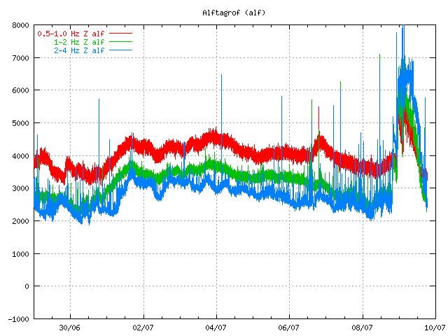
Tremor plot at 18:23 UTC. The tremor is dropping. It also shows that earthquakes are taking place (spikes the tremor chart). Copyright of this picture belongs to the Icelandic Met Office.
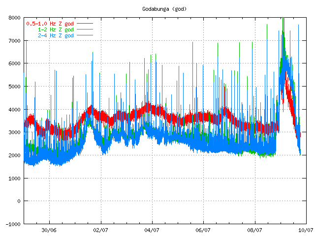
Tremor chart from Goðabunga at 18:24 UTC. Copyright of this picture belongs to the Icelandic Met Office.
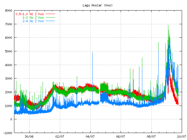
Dropping harmonic tremor on Lágu Hvolar. Earthquakes appear as spikes here. Copyright of this picture belongs to Icelandic Met Office.
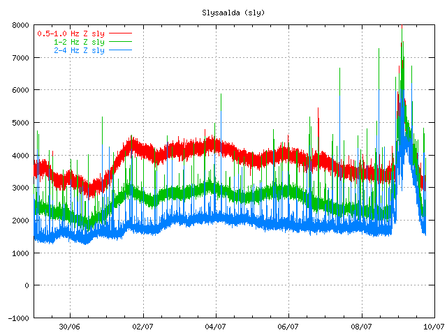
Dropping tremor and earthquakes as before. Copyright of this picture belongs to Icelandic Met Office.
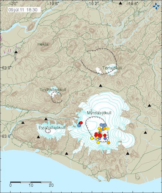
Earthquakes as they are tonight. The southern part of the caldera is having earthquake swarm, even if it is just an small one. Copyright of this picture belongs to Icelandic Met Office.
I am waiting too see how this develops. Something larger might happen. But nothing else might happen for an while in Katla volcano. The only thing that can be done is too wait and see what happens in Katla volcano.
Icelandic News about the road damage.
Meiri skemmdir en talið var (Rúv.is, Picture, Icelandic)

Ok guys enough of me being a voyeur (1 year)! I love this blog and hello! Jon you may not be an expert but show an understanding that most blogs and press do not. I am a Geologist but have only studied Iceland for my phd final. First thing I have Learnt is Iceland is well reasurched but little understood! Second thing I have Learnt is there is NO rule book when it comes to volcano`s
Keep up the good work an nice to find like-minded non Katla mongers!
And the third thing I have now learnt iis how to spell researched without spellcheck!
DoHH!
That’s why I like to say “studied”, it’s far easier to spell.
Some interesting comments by a few readers lately. They range from fear mongering to genuine curiosity.
Peter Pan “I guess the Katla will erupt within 48 hours.”
Zakos “Is there a possibilty of a full scale eruption of katla in the near future? ( by that I mean in the next few weeks)”
Noname “Could this potentially mean a bigger eruption is on the way?”
Volcanoes tend to behave and erupt in a similar way to how they historically behave…. except when they don’t.
Looking at Katla’s history, you should note that on average it erupts about every 64.5 years. This is using data from the Global Volcanism Program website. Looking at the data more closely, you will see that Katla only erupts within 20 years of it’s last event 12.3% of the time. The last noted event that could be called an eruption was in 1999, twelve years ago.
Can it happen? Yes. Is it going to? That really depends on Katla. You can’t say for sure.
Taking the long view, and looking only at events that are known to be VEI-3 or higher, things look differently.
Here are the normal distribution curves for events that match that criteria.
http://i52.tinypic.com/rhph7a.png
Two separate views of the data are here. The first is looking back to 920 AD to the present. In that case, on average, there is a VEI 3+ event every 78 years or so. Looking even further back, to 1920 BC, that number inches up to an average of 186 years.
The problem is that the further you go back, the less reliable the data is.
This can skew the numbers higher, since you are relying on a field geologist locating a tephra layer, doing the analysis on it and submitting the data. Nothing wrong with it, but there is a greater chance that the “more info” hasn’t been found yet.
Is it “overdue”? Not by a long shot. Notice that the 920 to present curve (probably the more accurate one) has a standard deviation of 137 years. Even though we are near the peak where the “average” is at… most of us will probably be long dead before we get beyond that “one standard deviation” realm.
Now… looking at the quakes under Katla, and updating my plot with the most recent, this is what you get.
View North
http://i51.tinypic.com/2m6mudf.png
View East
http://i52.tinypic.com/hte2q0.png
Perspective View looking North East
http://i55.tinypic.com/30kzqqp.png
There are three diffuse area where the quakes are clustered. Nothing really focused that can point at a pathway or chamber. The most recent “grouping” are the ones that show up in July.
Others here are better at pondering what these plots mean… so I will stop for now.
Enjoy.
Jon we all appreciate your hard work keeping the world informed. You are very honest and factual.
I am reposting this just in case some News of the World Ex- journalists are reading these posts. Maybe this will keep them off Jon’s and other hard working people’s backs.
As Stated this was the Google translation earlier today when I went to the IMO site…
All India – earthquakes during the last 48 hours.
(Preliminary results)
MapTable
Location shaky 09th July 14:35
Errrrm ! The above iscopied and pasted from my Google translation for Iceland Tremor Map title, Icelandic to English this evening!
They certainly got the ” locations are shaky”, bit correct. I wonder which newspaper will be first to send their Journalist to cover the Indian earthquakes?
Wise words Jack! Who needs sepel chuck anytwas!
http://www.youtube.com/watch?v=xVNBhRNWLpM
Video of the Glacial flood from this morning.
found it on youtube because RUV, doesnt works in my browser
Looks like tremor might be rising slightly again at Lágu Hvolar?
http://hraun.vedur.is/ja/oroi/hvo.gif
I think what happened was probably one or two phreatic explosions (caused by magma very close to surface), increased heat on the soil and melting ice, and probably also degasing, from the magma. Wasn’t the Civil Protection referring to strong sulphur smell and the presence of hydrogen sulfide in the areas around the glacier? But I don’t think we should call it an eruption. I think magma has probably pushed close to surface, and caused those phreatic explosions and degasing. But I dont think it reach surface. If it would, I guess this would open a path for a full scale eruption!
I think this minor activity happens “all the time” in Katla if you take a deep look at the history of the region there. People have talked for centuries about the danger of glacial floods from Myrdalsjokull – I guess these floods should had occurred more often that the big eruptions that we have the historic record (every 40-80 years).
This type of activity, specific to Katla, makes me think that this particular volcano has the routine of magma pushing close to surface and not erupting, hence the build up of pressure, and hence its powerful eruptions when the pressure cannot hold anymore.
Now, as we discuss this, we know that inflation has built under Katla for several years, it has even increased in past weeks (someone pointed out to the jump in the inflation in Oldufell, NE of Katla). This makes me think, that sooner or later there is going to be a large eruption. So far, the fact that this event has occurred could mean nothing (like 1999). Now, you ask whether this could also mean a full eruption. I guess we have to compare to what happened in 1999: were there any earthquakes swarms following the glacial month in that July 1999, or does this mean something else?
Finally, to finish my last speculative train of though (and this is just speculation), some scientists have raised the point that the Westman Islands could be connected to the Katla system. If this is so, then we would understand that the build-up in 1955 lead to the eruption in Surtsey in 1963, and the build-up in 1999 lead to the eruption of Eyjafjallajokull. As these eruptions happened, the pressure on Katla was reduced, and the eruption “delayed”. Naturally, I would now think this build-up of pressure in 2011 could mean that the full scale eruption of Katla could be very likely within the next years but could be still a few years ahead. But this is my personal dose of speculation.
I like your thinking.
http://vmkerfi.vedur.is/vatn/VV_Frame.php?r=27888&load_graph=1&direct=1&station_id=218&station_name=Su%F0urland&page_id=265
There is the charts for the waterlevel on the Múlakvísl. That was indeed a very sharp increase in the waterlevel and also in the conductivity of the water
i just looked at the conductivity levels for a 2 week timeframe of the river Múlakvísl and i found one very curious thing:
The conductivity has risen steadily since the 4. juli and later in the night from friday to saturday the conductivity has risen exponentionaly. (together with the waterlevel as the glacial flood)
My guess is that it was just the start of an eruption. There is less pressure on the magma chamber without the ice, so the real movement can begin now.
That did not happen in 1955 or 1999.
An eruption might occur tomorrow, in 2 months, or only 5 years from now.
I think an eruption will occur after a period of earthquakes, which signal that magma is breaking through the upper crust. This seems to be the case now. But if pressure from below is not enough, this will be delayed months or years.
So, as you can see, no one can control that pressure from below. The eruption might occur only years from now. My guess still goes for this autumn or later next year.
Grímsfjall / Grímsvötn behaved in a similar way in early November 2010
Not really. Grímsvötn has regular floodings, when the lake below the glacier overflows. At Katla you have these floodings only when you have some kind of activity.
Grimsvötn 2010 was due to increased hydrothermal activity caused by a magmatic intrusion. The evidence was harmonic tremor, which indicates magma movements.
Katla volcano is quiet for now. I am going to post new update soon on the current status.
So many magmatic intrusions in recent weeks !!
Since mid May: Askja, Grimsvotn (eruption), Hekla (2 days ago), Katla (today)
Katla cam more fun than television! Just watched from 23:55 to 00:25 11/7/10
Watching those low clouds forming around the hills in the center foreground,,,stunningly beautiful. The 4×4 with Puppydog running behind, the icing on the cake. Iceland looks a truly wonderful country.
Hi Jón & everyone-
Your blog is fantastic Jón! It is reminding me how science is not always a concrete form of knowledge, and that human instinct still has a place! Just wondering if there is a good book/website laypeople can go to learn about basic terms and how to read graphs you are all discussing, or a centre in Iceland for volcanoes? Following some of it, but a lot is beyond me. I’m an artist looking at making an exhibition about the Iceland volcanoes (& glaciers). Trying to get find a way to meet an Icelandic vulcanologist or local enthusiast (who can speak english) while in Iceland who can give more information about life with volcanoes- the science, and day to day realities when they erupt. Not sure if Jón or Irpsit know anyone or would be interested? If so please let me know. Thank you.
Question, but not quite sure what I am asking yet…
You know how some of the earthquakes are really shallow depth, but their depth is measured under the rock rather than under the top of the glacier. Well, does the shape of the rock match the shape of the glacier, or is the glacier “shallower” in some places, with underlying rock more uneven.
I ask because the Katla cam looks lovely and smooth, but volcanoes like Etna that aren’t under a glacier are kind of jagged.
I think that I am asking how accurate the very shallow depth earthquakes are. How reasonable is it to record an earthquake at 100m (0.1Km) deep when there might be 200m or 300m of ice above it?
New blog post is up!