Magnitude 3.3 earthquake in Bárðarbunga volcano during the night

At 02:55 UTC today (18.12.2012) there was a magnitude 3.3 earthquake in Bárðarbunga volcano system. Earthquakes are common in this area so this activity is no surprise. Origins of this earthquakes are due to tectonic movements in the area. Not magma related changes.


Green star marks the magnitude 3.3 earthquake in Bárðarbunga volcano system. Copyright of this image belongs to Icelandic Meteorological Office.

Aftershocks have followed this earthquake. So far the largest one got the magnitude 2.2. More earthquake activity can be expected in this area. But that is normal and not unexpected.

Weak harmonic tremor pulse from Hamarinn volcano

Since around 19:00 UTC (16.10.2012) a harmonic tremor pulse has been taking place in Hamarinn volcano (Bárðarbunga volcano). There is in my view no eruption taking place at the moment. This is most likely a dike intrusion of magma somewhere in the area of Hamarinn volcano. That might however trigger an eruption. But we just need to wait and see on that for the time being. This activity is interesting, as there was a small eruption in this area in July 2011.


The harmonic tremor pulse is strongest on this SIL station. But it is weak regardless. The signal suggest this event is taking place close to this SIL station location. Copyright of this image belongs to Icelandic Meteorological Office.


The harmonic tremor pulse also appears on Skrokkalda SIL station. But is weak and can hardly be detected on it. Copyright of this image belongs to Icelandic Meteorological Office.

The harmonic tremor pulse can be seen at the end of the above SIL station traces. The harmonic tremor pulse is higher then normal background noise (wind, ocean waves, human traffic, etc) on the SIL station. I do not expect this to be noise. The signal is too strong for that. It also hard to travel in this part of Iceland in October due to bad weather and difficult conditions in the high areas of Iceland.

Minor dike intrusion into Bárðarbunga volcano and earthquakes deep south of Iceland

Yesterday (03.02.2012) at 10:42 to 10:47 UTC there was an minor dike intrusion into Bárðarbunga volcano. Based on the earthquake activity and the depth that they where on. It seems that they did not go close to the surface. Based on the earthquake pattern, the dike intrusion did only go up to the depth of 12 km. But this dike intrusion did rise up from the depth of 22 km.


The dike intrusion into Bárðarbunga volcano. It can be seen by the dense earthquake swarm in Bárðarbunga volcano. Copyright of this picture belongs to IMO.

It is hard to know what this means. But it is for sure an clear sign of more activity in Bárðarbunga volcano. But this is no clear sign that an eruption might be about to take place in the nearby future.

Reykjanes Ridge

Yesterday (03.02.2012) there was an earthquake swarm deep south of Iceland. This earthquake swarm was located on the Reykjanes Ridge. It is impossible to know for sure what was going on at this location due to distance from land. But the average distance of this earthquake swarm is about 450 km south of Eldeyjarboða on the Reykjanes Ridge. The recorded size of this earthquake swarm was from ML3.1 to ML3.3. But that is most likely an underestimate of the earthquake size due to distance from the SIL network.


The star mark the earthquakes. Copyright of this picture belongs to IMO.

Other then this it has been quiet in Iceland. But that has more to due with storms and bad weather. But it has also been quiet in Iceland during the past few weeks. It might continue like that for some time now. When this ends is impossible to know for sure.

Earthquake swarm in Bárðarbunga volcano

During the night there was an small earthquake swarm in Bárðarbunga volcano. The largest earthquake in this earthquake swarm was ML3.04 in magnitude. It had the depth of 8.5 km. This might have been a n dike intrusion. But it is hard to know that for sure at the moment. This earthquake swarm only lasted for an about 2 to 3 hours before it stopped.


The location of the earthquake swarm in Bárðarbunga volcano. Copyright of this picture belongs to Iceland Meteorological Office.


The earthquake swarm also did appear clearly on the tremor plots on the SIL stations that are close to Bárðarbunga volcano. The second set of spikes there are from Hamarinn volcano. Copyright of this picture belongs to Iceland Meteorological Office.


This earthquake swarm was also seen on Grímsfjall volcano SIL station. The rise in harmonic tremor is due to a storm that is passing over Iceland at the moment (going to go over Iceland today). Copyright of this picture belongs to Iceland Meteorological Office.

Hamarinn volcano

Following the earthquake swarm in Bárðarbunga volcano an earthquake swarm did start in Hamarinn volcano. This earthquake swarm is so far small and the largest earthquake so far is an ML1.9 in magnitude. But Hamarinn volcano had an minor eruption in July 2011. That minor eruption created an glacier flood that was larger then the flood that did come from Mýrdalsjökull glacier the week earlier. Activity after that has however been little and few earthquakes have taken place. It is impossible to know if there is going to be any more eruptions in Hamarinn volcano. But it cannot be ruled out given current activity in it.

Year in review on Rúv News

Rúv News has put up an page with major events in Iceland during the year 2011.

Grímsfjall volcano eruption in May 2011 can be viewed here.
The glacier flood from Mýrdalsjökull glacier due to the small eruption in Katla volcano can be found here. Sadly there is no mention of glacier flood from Hamarinn volcano yet.

This video should be available outside Iceland. If it is not. Please let me know I can send an complain email to Rúv News about it.

Tremor pulses in Hamarinn volcano (most likely)

During the past two weeks there have been tremor pulses in Hamarinn volcano (is claimed to be part of Bárðarbunga volcano system), at least most likely that volcano. But it might also be a volcano that I call Skrokkalda Volcano (other name might be Hágöngur volcano) (it has no entry on GVP web page, I do not know why). But given recent history I find it unlikely to be the case.

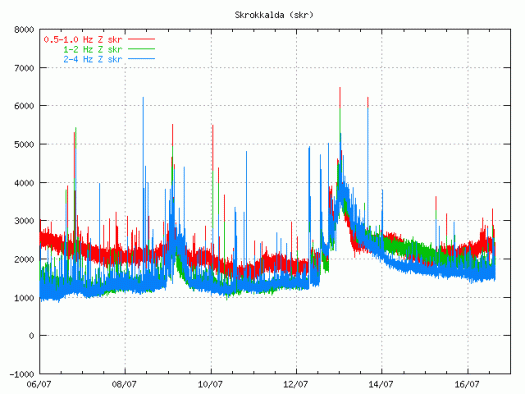
This harmonic tremors might be due to dike intrusions. I find it unlikely to be from a man made lake called Hágöngulón that is in this area. The harmonic tremor pulses look like sharp spikes on the tremor plot on the Skrokkalda SIL station.


Harmonic tremor spikes from Hamarinn volcano. Copyright of this picture belongs to Iceland Met Office.

This pattern of harmonic tremor spikes was seen all last year and all of the year 2009 from what I can remember. I do not have tremor charts from that period. But however this suggests that more magma has now started to flow into Hamarinn volcano. But there was a small volcano eruption (it seems so, given the flood that took place in July) in Hamarinn volcano last summer (summer 2011). What happens next is a good question.

This process of inflow of magma seems to without earthquakes, or close to it. I do not know why that is and I have no ideas that explain it.

Overview of Hamarinn volcano current activity

Here is a short overview of the Hamarinn volcano activity this summer. From what I can gather in the current data this is most likely not over. During the past few days there have been at least suspected two minor eruption in Hamarinn volcano. But it hard to confirm it due to glacier that is covering this area.

This all starts on 12. July 2011 at 07:30 UTC with this event here.


The tremor spike on 12. July 2011 at 07:49 UTC. Copyright of this picture belongs to Icelandic Met Office.

When the clock is around 19:10 UTC the same day the tremor chart looks like this.


The tremor spikes are now three on 12. July 2011 at 19:09 UTC. Copyright of this picture belongs to Icelandic Met Office.

On the 13. July 2011 the tremor plot looks like this. But at that time the glacier flood had started and broken from the Vatnajökull glacier.


The tremor chart at 13. July 2011 at 01:10 UTC. Copyright of this picture belongs to Icelandic Met Office.


The tremor chart at 13. July 2011 at 12:59 UTC. Copyright of this picture belongs to Icelandic Met Office.

Then there was a short period of break when nothing interesting happened in Hamarinn volcano. That break did last until 16. July 2011 when a new, but smaller spike did appear on Skrokkalda SIL station.


The tremor at 16. July 2011 at 15:22 UTC. It is not fully clear what did happen at this time. But this was most likely a earthquake in Hamarinn volcano. But that is yet unconfirmed at this time. Copyright of this picture belongs to Icelandic Met Office.

Then there is a new break that lasts until 1. August when a earthquakes happens deep under Bárðarbunga volcano. But the deepest earthquake had the depth of 25.2 km. But it is also important to notice this earthquake that took place on 13. July 2011 and it is from Hamarinn volcano.


The earthquake from Hamarinn volcano. This picture is released under Creative Commons licence. Please see licence web page for more details.

On the 3. August 2011 around 02:00 UTC a new harmonic tremor spike starts to be visible on Skrokkalda SIL station.


The tremor plot at 01:55 UTC on 3. August 2011. Copyright of this picture belongs to Icelandic Met Office.

This day two minor harmonic tremor happens. A change in Skaftá glacier river is noticed. That is higher conductivity and slightly more water. It was announced in the news that a Skaftá glacier river flood was about to start from the eastern glacier cauldron that is formed above the Hamarinn volcano. Today however that does not seem to be the case. As no glacier flood has taken place so far.

Today (5. August 2011) there was a new harmonic tremor spike on Skrokkalda SIL station. It did follow the same pattern as before. It started and lasted for about 20 to 60 minutes or about that long.


The tremor chart 5. August 2011 at 17:38 UTC. Copyright of this image belongs to Icelandic Met Office.

So far today only one harmonic tremor has been detected. But given the past experience that is unlikely to hold for a long time now. But it is impossible to know when a new event starts or how big it is going to be.

The original event on 12. July 2011 did create new cauldron in the glacier. This map from Icelandic Met Office shows the location of those new cauldrons. But it has been marked with a star on the map. The coloured dots are earthquakes in this area over the past few years.


Map of the area that is currently active in Hamarinn volcano. Copyright of this image belongs to Icelandic Met Office.

Given the current data I am expect a full scale eruption in this area soon. When is hard to know for sure. But until that happens there are going to be more smaller eruptions in this area. I do not know why there is a lack of earthquakes following this events. I cannot explain it. But because of that this can only be seen after it has started on the tremor charts.

Sharp rise in harmonic tremor on Skrokkalda and Grímsfjall SIL station (among others)

There is a sharp rise in harmonic tremor on the Skrokkalda and Grímsfjall SIL station. I do not know yet what volcano is responsible for it. But the Hamarinn volcano is a suspect at the moment.

Current tremor plot.


The tremor spike is at the end of this tremor plot. Copyright of this picture belongs to Icelandic Met Office.


The tremor spike is at the end of this tremor plot. Copyright of this picture belongs to Icelandic Met Office.

I am going to post more information about what is going on when I know more. This blog post might get updated soon if needed.

Interesting earthquakes in Bárðarbunga volcano system (Hamarinn volcano)

At 02:06 and 02:07 UTC there where interesting earthquakes in Bárðarbunga volcano system. What makes them interesting is that fact they did happen at 0.6 km depth one of them. But this area did see some volcano related activity (speculated) earlier this summer, that did result in large glacier flood. But it has been suggested that a minor eruption took place there around 10. July 2011.


The two earthquakes can be seen as spikes at the end of this tremor plot from Icelandic Met Office. Copyright of this picture belongs to Icelandic Met Office.

What makes this earthquakes so interesting is that they seem to have a low period component in them. But it was seen on the Kálfafell SIL station, and other SIL station that was decent distance from the source of the earthquake.


The two earthquakes can be seen as spikes at the end of this tremor plot from Icelandic Met Office. Copyright of this picture belongs to Icelandic Met Office.

Currently there is nothing that suggests that a eruption is about to start in this area. But that can change without warning given the current status of Hamarinn volcano system.

Small harmonic tremor spike from Hamarinn volcano

There seems to be a small harmonic tremor spike taking place in Hamarinn volcano (Bárðarbunga volcano) at the moment. This tremor spike is not strong at the moment. This tremor spike appears to have been pre-seeded by few long period earthquakes (not all of the earthquakes seen on Skrokkalda are from Hamarinn volcano, few are from Katla volcano), but that suggests that magma is on the move in Hamarinn volcano. But this would the second harmonic tremor in a time period of 48 hours it seems.


The harmonic tremor spikes can be seen at the end of this tremor plot. Copyright of this picture belongs to Icelandic Met Office.

Currently it is impossible to know what happens in Hamarinn volcano. As it’s pre-eruption behaviour is rather unknown. But if there is a eruption in this area I am expecting a lot of earthquakes, with size well over ML3.0.

Blog post updated at 16:20 UTC.

Possible minor eruption in Hamarinn volcano yesterday. Update on Katla volcano

There appears to be more in this new hydrothermal activity in Hamarinn volcano then at first sight. It seems that this actually might have a eruption in Hamarinn volcano (Bárðarbunga volcano). If this event is confirmed, this is the first eruption in Hamarinn volcano since the year 1910.

This also mean that there is a chance of more activity in this area in coming weeks or months. But when it might happen is impossible to know.


The new cauldrons are marked with a “X” on this map. Copyright of this picture belongs to Icelandic Met Office.

This eruption was really small and did just last for few hours. But it was able to melt a lot of ice and create rather large glacier flood from Vatnajökull glacier. If the activity resumes in this area this is going to repeat it self in terms of glacier flood.

Icelandic News about this event.

Innskot af kviku (Rúv.is, Icelandic)
Eldgos gæti hafa brotist upp við Hamarinn (Vísir.is, Icelandic, Pictures)
Fundu nýjan sigketil (mbl.is, Icelandic, Pictures)

Sigketill við Lokahrygg (Icelandic Met Office, Icelandic, Pictures)

Update on Katla volcano

Here is a short update on Katla volcano. There have been repeated short burst of harmonic tremors taking place inside the Katla volcano caldera. This harmonic tremor spikes have been small and they are hard to see on the harmonic tremor graph that Icelandic Met Office has on-line. Other then this it has been quiet so far in Katla volcano.