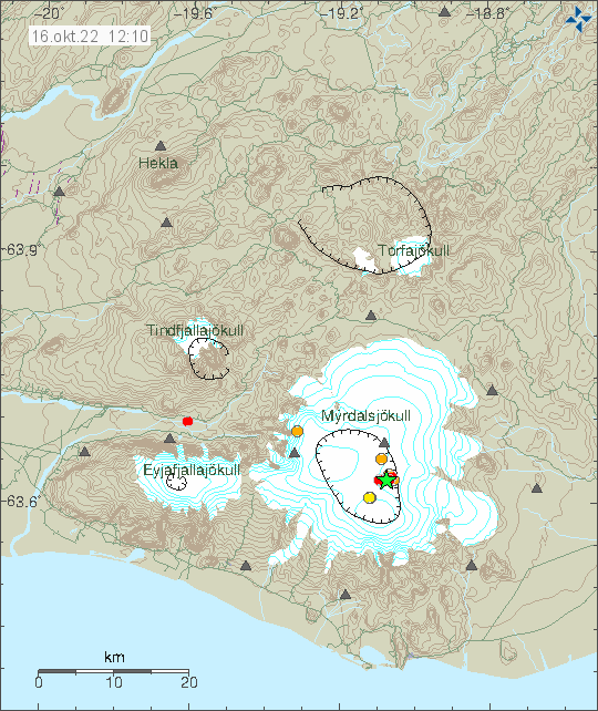
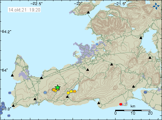
Today (16-October-2022) an earthquake swarm started in Katla volcano in Mýrdalsjökull glacier. Largest earthquake at the writing of this article had a magnitude of Mw3,8. I don’t know if it was felt in nearby towns and farms. Second largest earthquake had a magnitude of Mw3,0.
Earthquake activity in Katla volcano. Copyright of this image belongs to Icelandic Met Office.
This earthquake swarm is ongoing at the writing of this article and the situation can change quickly. This might be a normal earthquake swarm and nothing more might happen. This type of earthquake swarm is not uncommon and I am not sure what is required for an eruption to start in Katla volcano.
The earthquake today (11-November-2021) at 13:21 UTC with the magnitude of Mw5,2 seems to align it self with faults that are part of SISZ rather than being part of Hekla volcano system. The high frequency tone on 2 – 4Hz that I did see on few nearby SIL stations has started to lower again after the main earthquake. Earthquake activity in the area is currently dropping but it might increase again without warning.
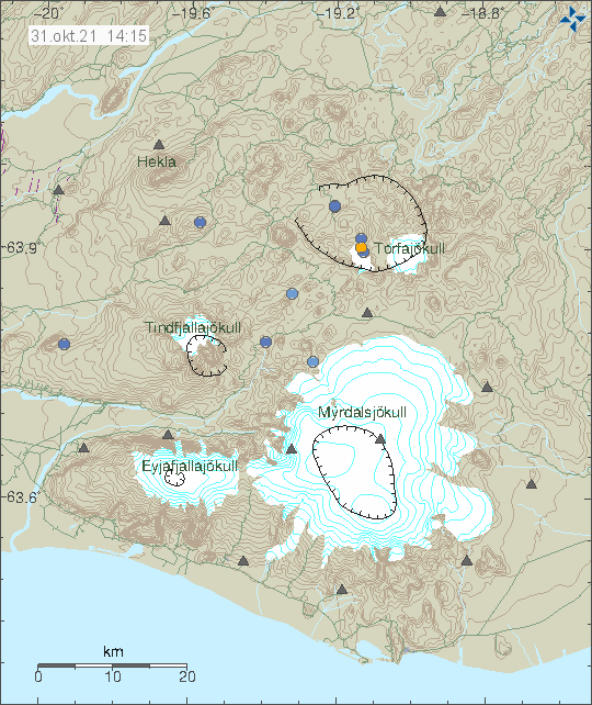
Around 10:00 UTC this morning (31-October-2021) the earthquake activity of long period and low frequency earthquakes increased this morning in Torfajökull volcano. The current swarm now seems to be coming from the glacier part of the caldera, the earlier activity seems to have taken part some place in north part of the Torfajökull volcano caldera. Location of the this earthquake activity is difficult if not impossible because of the type of earthquake activity being generated in Torfajökull volcano.
The located earthquake activity in Torfajökull volcano. Copyright of this image belongs to Icelandic Met Office.
The situation is difficult to figure out just by looking at seismometer data. Icelandic Met Office is going to make a flyover today with the help of Icelandic Coast guard and try and see what is going on in Torfajökull volcano. Last eruption in Torfajökull volcano was in the year 1477 and I don’t have any idea what happens before an eruption in this volcano.
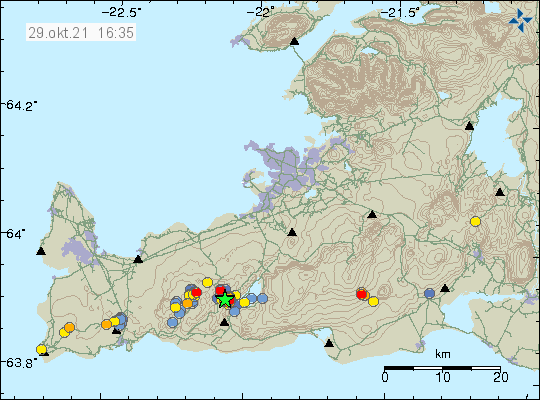
Yesterday (28-October-2021) two earthquakes with magnitude of Mw3,6 and Mw3,0 took place west of Kleifarvatn lake (in Krýsuvík-Trölladyngja volcano system). The first earthquake with magnitude of Mw3,6 took place at 18:36 UTC and the second earthquake with magnitude of Mw3,0 took place at 23:11 UTC. Other earthquakes that took place where smaller in magnitude.
The earthquake activity in Krýsuvík-Trölladyngja volcano system. Copyright of this image belongs to Icelandic Met Office.
This earthquake activity seems to be connected to magma movements in the area. It has not yet and might not result in a eruption since this is in a different fissure area. It is unlikely that this activity is connected to the magma movements that are ongoing close to Fagradalsfjall mountain.
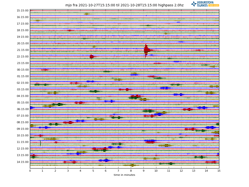
According to an announcement made by Icelandic Met Office there has been a swarm of low frequency earthquakes in Torfajökull volcano since midnight of 28-October-2021. The earthquakes don’t appear clearly on the Icelandic Met Office map but they can be seen on nearby SIL stations. According to Icelandic Met Office the rate of earthquake activity is about 1 – 2 earthquake every 15 minutes.
Earthquake activity in Torfajökull volcano. Copyright of this image belongs to Icelandic Met Office.
Harmonic tremor activity showing the earthquake activity. Copyright of this image belongs to Icelandic Met Office.
There are two things that can create this type of low frequency activity. The first one is water that has been superheated in the crust. The second option is that magma is now moving in Torfajökull volcano. This type of activity has happened before without any eruption happening. I think that is going to be the same now at the writing of this article. Since this is an active volcano the situation can change quickly and without warning.
There are no web cameras in the area that I know of. It is remote and there is almost no mobile coverage at this location. If there is a mobile connection, it is limited to 2G (GSM) or slow 3G connection.
Earthquake activity continues close to Keilir mountain. But it remains at depth of 5 to 6 km and doesn’t show any sign that it is about to move to the surface. More than 10000 earthquakes have been recorded and 18 earthquakes have been recorded with magnitude above Mw3,0. This is according to Icelandic Met Office.
Earthquake activity close to Keilir mountain on Reykjanes peninsula. Copyright of this image belongs to Icelandic Met Office.
The eruption in Fagradalsfjall mountain (more information at Krýsuvík-Trölladyngja website at Global Volcanism Program) has not been active since 19-September-2021 and there are no signs that the eruption is about to restart soon. Global Volcanism Program no longer updates its information for this volcano as an active eruption. Icelandic scientists in eruptions have not declared the eruption over. It should be expected that the eruption in Fagradalsfjall mountain is over for now, but it can start again at the same location or at new location in few weeks time or maybe even few years from now.
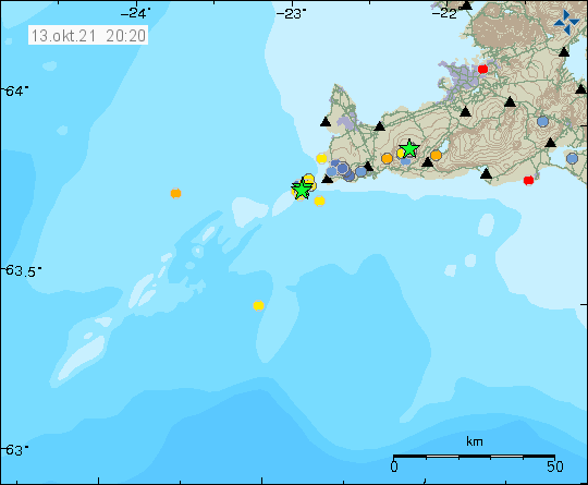
Yesterday (12-October-2021) an earthquake swarm took place in Reykjanes volcano. Largest earthquake in this swarm had a magnitude of Mw3,3 and the earthquake swarm was out in the ocean not far from the coastline.
Earthquake activity out in the ocean on Reykjanes ridge. Copyright of this image belongs to Icelandic Met Office.
It is impossible to know for sure if this earthquake activity is directly connected to magma movements in this area. It is possible, but there have been some sign of magma moving in the crust in this area. The magma is moving but is not erupting or starting an eruption. Earthquake activity seems to be growing in this area of Reykjanes peninsula and Reykjanes ridge after the eruption in Fagradalsfjall mountain stopped.
Inflation has been increasing in Askja volcano over the last few weeks. According to latest news that inflation is now at 14 cm, since the inflation was detected at the end of August. On Saturday 9-October-2021 an earthquake with magnitude of Mw3,2 was detected in Askja volcano (I’ll try and add the picture later if I remember). This is was the strongest earthquake in Askja volcano in the last 20 years according to the news.
Askja is remote and there are no or limited amounts of web cameras in the area. With winter arriving going there is impossible for most people. If an eruption happens this winter the best view is probably going to be harmonic tremor data until pictures appears from Icelandic Met Office or someone with an air plane (if the weather allows for that).
Cookie acceptance
We use cookies on our website to give you the most relevant experience by remembering your preferences and repeat visits. By clicking “Accept”, you consent to the use of ALL the cookies.
This website uses cookies to improve your experience while you navigate through the website. Out of these cookies, the cookies that are categorized as necessary are stored on your browser as they are essential for the working of basic functionalities of the website. We also use third-party cookies that help us analyze and understand how you use this website. These cookies will be stored in your browser only with your consent. You also have the option to opt-out of these cookies. But opting out of some of these cookies may have an effect on your browsing experience.
Necessary cookies are absolutely essential for the website to function properly. This category only includes cookies that ensures basic functionalities and security features of the website. These cookies do not store any personal information.
Functional cookies help to perform certain functionalities like sharing the content of the website on social media platforms, collect feedbacks, and other third-party features.
Performance cookies are used to understand and analyze the key performance indexes of the website which helps in delivering a better user experience for the visitors.
Analytical cookies are used to understand how visitors interact with the website. These cookies help provide information on metrics the number of visitors, bounce rate, traffic source, etc.
Advertisement cookies are used to provide visitors with relevant ads and marketing campaigns. These cookies track visitors across websites and collect information to provide customized ads.