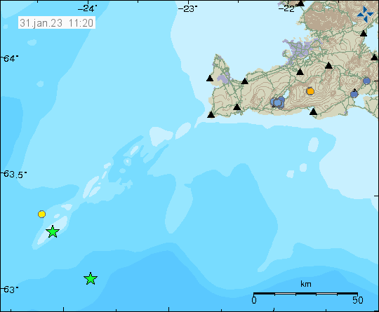
Yesterday (30. January 2023) had two earthquakes with magnitude Mw3,2 far off the coast on the Reykjanes ridge. Only one smaller earthquake was detected. Distance from the SIL network makes detection of smaller earthquakes is impossible or really difficult.
Earthquakes on the Reykjanes ridge yesterday. Copyright of this image belongs to Icelandic Met Office.
Besides this earthquake activity, it remains quiet in Iceland. Bad weather has also been blocking detection of earthquake activity for the last two weeks.
Few inflation related earthquakes have taken place in Bárðarbunga volcano this evening. This earthquake activity shows that Bárðarbunga volcano continues to inflate at a fast rate since end of the eruption in February 2015. Continue reading “Earthquake in Bárðarbunga volcano”
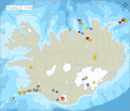
Today (15. December 2022) an earthquake swarm has been going around 45 km east of location known as Fonti in eastern Iceland. This location is out in the ocean and its unclear why this earthquake activity is happening. There are no volcanoes in this part of Iceland and no known fault areas. Since this is among the oldest parts of Iceland.
Largest earthquake in this swarm recorded so far, had the magnitude of M2,9. Distance from the SIL network prevents detection of smaller earthquakes in this area.
Earthquake swarm far east of Fonti in eastern Iceland. Copyright of this image belongs to Icelandic Met Office.Close up image of the earthquake activity from Skjálfta Lísa earthquake viewer on Icelandic Met Office website. This only shows reviewed earthquakes. Copyright of this image belongs to Icelandic Met Office.
There is a risk of stronger earthquakes in this area. If this earthquakes are going to be felt in populated areas is unlikely unless this earthquake activity gets really big. Since this earthquake activity is far from the coastline and there’s almost no population in this parts of Iceland.
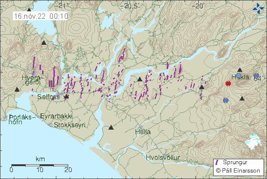
This started on Monday (14-November-2022) with an earthquake of magnitude Mw2,0 at 25,6km depth. This depth is as deep as the crust goes in this location of Iceland. This earthquake activity has been followed by two micro-earthquakes of magnitude of Mw0,5 and Mw0,6 at 11,5 km depth.
Earthquake activity in Hekla volcano. Picture from Icelandic Met Office.
There are no clear or obvious signs that Hekla volcano is about to do anything. But this deep earthquake activity suggests magma movements at depth or pressure changes maybe. This is clearly not a big activity and at the writing of this article I don’t expect anything to happen.
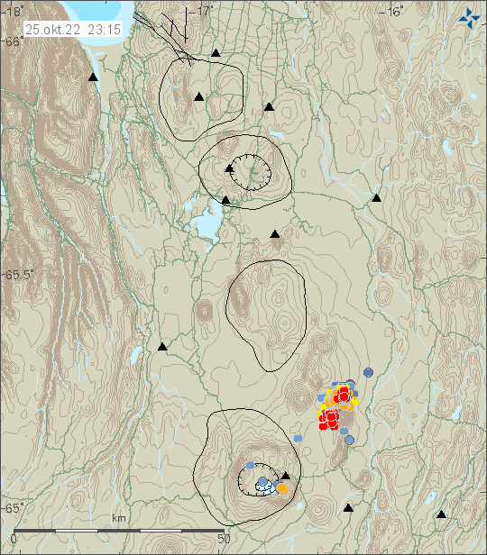
Sometime yesterday (24-October-2022) a change happened in the earthquake swarm close to Herðubreið mountain. I am not sure when that change happened and it probably took few hours to happen before I detected it. But the change seems to be that now the earthquake swarm is at two locations and not just one. The second change is that the earthquake swarm is now getting more intense. The earthquakes at the writing of this article are minor, only magnitude Mw0,0 to Mw2,7 at the strongest. Nothing above Mw3,0 so far, but that might change without warning. Depth of this earthquake swarm is around 2 to 3 km at the writing of this article.
Earthquake activity close to Herðubreið mountain. Picture from Icelandic Met Office.
What is going to happen next is impossible to know. An eruption in this area has not happened for at least 12.000 years or even longer. I don’t know if stronger earthquake activity is required for this area for an eruption to happen. It already is rather fractured from older earthquake activity and rift activity, that makes it possible for magma to have easier paths to the surface without much earthquake activity. That is at least one idea on the situation in this area. I might be wrong on this, since I don’t have information on the finer details of the crust around Herðubreið mountain.
This earthquake activity is ongoing at the writing of this article.
I normally don’t write article this late unless I think it is important.
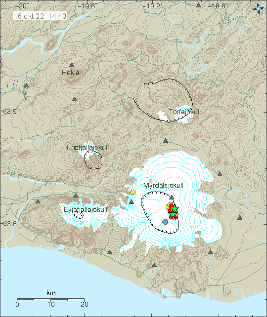
This earthquake activity in Katla volcano seems to be at that nature that it is worth writing a short article about it this late. At 00:46 UTC an earthquake with magnitude of Mw3,6 (this is early reviewed earthquake magnitude, it might change when reviewed later tomorrow at Icelandic Met Office). Few smaller earthquakes have happened following this earthquake. Currently the earthquake activity is slow and it is possible that nothing more might happen.
Earthquake activity in Katla volcano. Picture from Icelandic Met Office.
I don’t know if this is a sign of an eruption that is going to happen or if this is just an earthquake activity that happens regularly in Katla volcano. There are now 104 years since last major eruption in Katla volcano and the situation is unclear on what is going on. If anything more happens I am going to write an update tomorrow. There’s a good chance nothing more might happen, but it is worth keeping a watch out for this if anything changes suddenly.
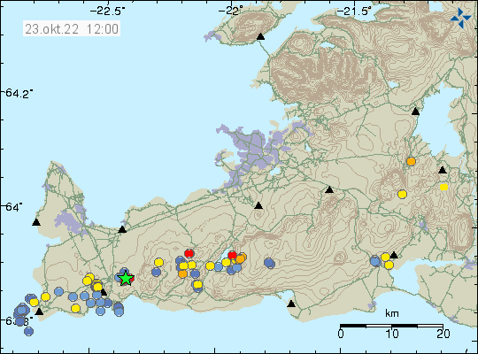
This morning on 23-October-2022 an earthquake swarm took place in west part of Fagradalsfjall volcano. Largest earthquake in this swarm so far had a magnitude of Mw3,0.
Earthquake activity west of Fagradalsfjall volcano. Picture from Icelandic Met Office.
This earthquake activity is the result of magma pushing up into the crust at around 5 km depth. This is not a large dyke intrusion and possibly won’t result in a eruption, unless there’s a sharp increase in earthquake activity and that has happened (the August 2022 eruption started this way). This is currently a situation that requires monitoring for changes. If anything is going to happen is impossible to know.
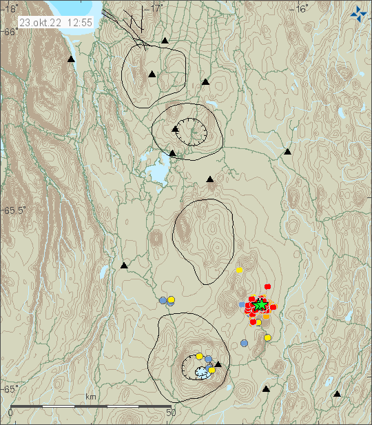
During the night of 23-October-2022 an earthquake swarm started north of Herðubreið mountain. This looks like a tectonic earthquake swarm, rather then a magma related activity. At the writing of this article, over 500 earthquakes have been recorded.
Earthquake activity north of Herðubreið mountain. Picture is from Icelandic Met Office.
Largest earthquake at the writing of this article had a magnitude Mw4,0 and one magnitude Mw3,1 earthquake took place. Second largest earthquake had a magnitude of Mw3,3. This earthquake swarm is ongoing at the writing of this article and there’s still a risk of larger earthquakes happening north of Herðubreið mountain. The largest earthquake was felt in Akureyri according to news reports.
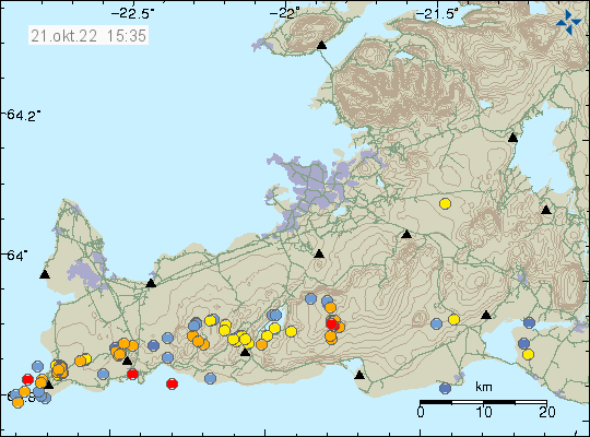
Today (21-October-2022) an earthquake swarm took place in Brennisteinsfjöll volcano. Largest earthquake had a magnitude of Mw3,0 at 10:23 UTC. This earthquake swarm is possibly over, it is however difficult to be sure.
Earthquake activity in Brennisteinsfjöll volcano and other nearby volcanoes. Picture is from Icelandic Met Office.
This is probably just a tectonic earthquake activity. But it is worth noting that volcano activity as has been seen in Fagradalsfjall volcano (Iceland newest volcano) is going to move east on Reykjanes peninsula. How fast and how long that change is going to happen is not known because of lack of data and written records from 700 to 900 years ago are incomplete and vague on details at best.
The police and Icelandic Met Office have now advised people not to go to Mýrdalsjökull glacier. This is after the earthquake swarm earlier today. According to Icelandic Met Office this earthquake swarm is similar to what happened before the minor eruption in Katla volcano in July 2011 that resulted in a glacier flood down Mýrdalssand and destroyed the bridge over the glacier river in that area. All trips to see ice caves in Mýrdalsjökull glacier have been temporarily forbidden by the Icelandic Police.
Earthquake activity in Katla volcano. Copyright of this image belongs to Icelandic Met Office.
In July 2011 it took around 24 hours from the start of the earthquake activity then until something happened. If that is going to be case now I don’t know. That this activity is similar to July 2011 eruption is worrying. The eruption in July 2011 was minor and didn’t break the glacier, but it resulted in damage in that area from the glacier flood.
Largest earthquakes now have the magnitude of Mw3,8 and Mw3,0 (few of them). Other earthquakes have been smaller in magnitude but that might change without warning.