This is a short update. Information there might go outdated quickly and without warning. This article is written on Wednesday 22. November 2023 at 21:32 UTC.
There’s little news to report at this moment. Mostly because of bad weather. The progress of the dyke has also stalled from earlier, or this might be it for now. It is difficult be sure currently.
The risk zone around Grindavík. Copyright of this image belongs to Icelandic Met Office.
The inflation at Svartsengi (upwards movement) stopped in the last 24 hours. This either means this series of events is stopping for now or something major is about to happen. I am not sure. Risk of this being a error are small, but this might be interference from weather (rain, snow).
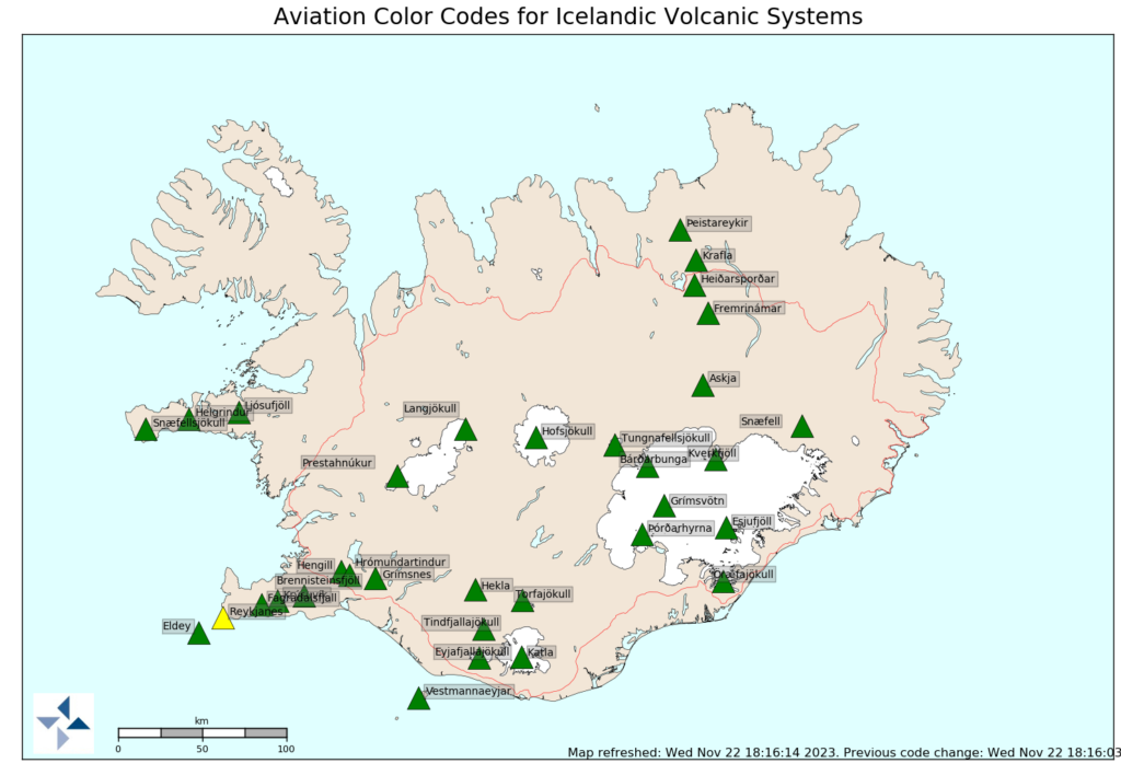
The air code for Reykjanes volcano has been downgraded to yellow.
The aviation colour code of volcanoes in Iceland. Copyright of this image belongs to Icelandic Met Office.
The situation in Grindavík and in Sundhnúkagígar and the nearby area can still change without much warning. Since the ground is very fractured there and is not going to be much resistance to any magma movements in the near future.
If anything more happens. I’ll update soon as I can.
This is a short update on the situation in Grindavík. This article is written on 20. November 2023 at 22:22 UTC.
Storm warning
There’s a storm in Iceland until 23. November 2023. When the wind is going to start die down again. This means that Icelandic Met Office is going to record fewer earthquakes because strong ocean waves and wind.
Daily update
There has not been much change since yesterday. This is normal.
Inflation in Svartsengi is up to 30mm/day and this is a increase, since inflation used to be around 15mm/day.
Since Friday 10. November 2023 the inflation in Svartsengi has been around 150mm over the last 11 day time period.
It took 17 days from start on October 25 of the magma inflow into the Svartsengi dyke until it broke on 10. November and the created the Sundhnúkar to Grindavík dyke.
It is a question what happens when next 17 days come up. Because whatever the hold is for the magma in the dyke in Svartsengi is going to break it is going to start the process as happened on 10. November 2023 and possibly into the current dyke, or possibly create a new dyke next to the current one (its a possibility, not a large one, but it is there).
Other updates
There has not been a lot of information released today and I don’t see a lot on seismometers and other instruments around Grindavík town currently.
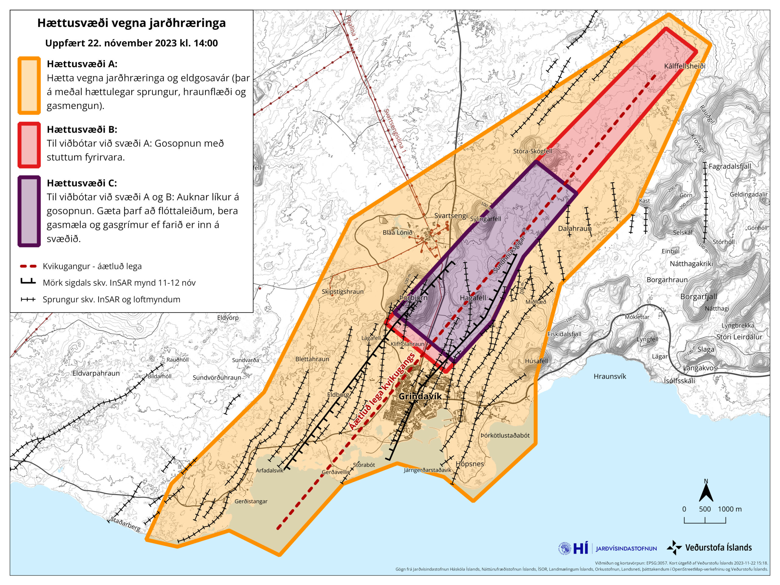
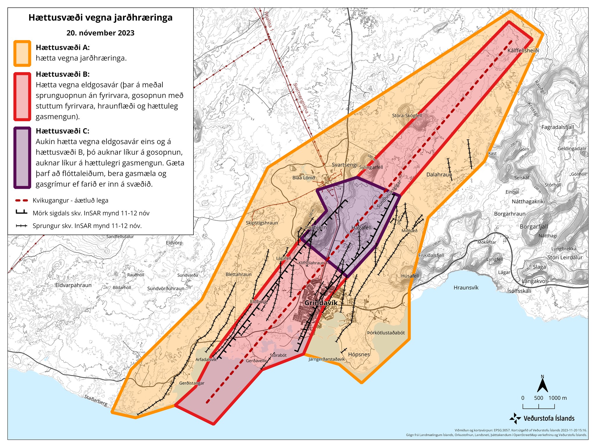
The current danger zone map from Icelandic Met Office. Zone A (orange) is the least dangerous area. Zone B (Red) is a dangerous zone, risk of fissures opening up, erupting crates, lava flows and gas pollution. Zone C (purple) is the most dangerous zone, Its close to same as zone b, but increased risk of dangerous volcano gases and entering it requires wearing a gas mask, have a gas and have gas measurement tool when going into the zone. Red dotted line is the estimated location of the dyke. This map also shows fissures in this area and the rift valley. Copyright of this image belongs to Icelandic Met Office.
This type of quiet period before an eruption are common. Why is not well understood. Eruption might not happen, but it is not likely that nothing is going to happen in this. Both is magma too close too the surface and there’s too much inflow of magma into the dyke at Svartsengi. This is how I see the current situation.
If anything happens. I’ll post update soon as I can.
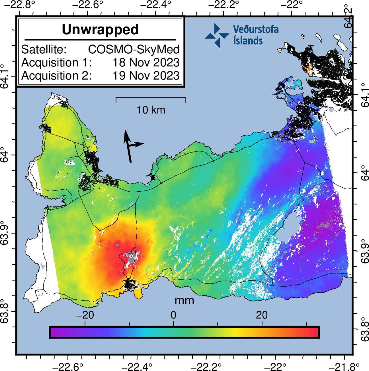
This is a short update on the activity in Grindavík on 19. November 2023. Information here might go out of date without warning. This article is written at 22:28 UTC.
Krýsuvík earthquake
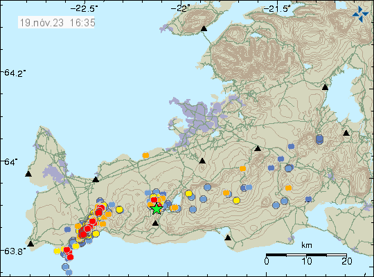
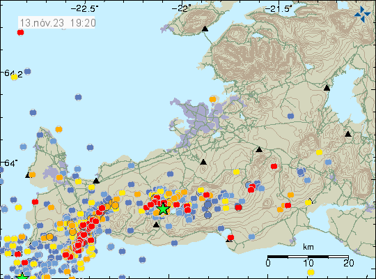
This morning an earthquake with magnitude of Mw3,7 took place in Krýsuvík-Trölladyngja volcano. This earthquake was felt in Reykjavík area. This earthquake happens because of all the displacement that is now happening next to Grindavík town.
The earthquake activity in Krýsuvík-Trölladynga volcano. Copyright of this image belongs to Icelandic Met Office.
Daily update
This is also an update for 18. November 2023. I was trying to get a little time off from writing.
Little has changed in last two days. Parts of Grindavík town continue to sink or rise depending on location. Most measured movements is around 25 cm last I did see. If that is correct today I am not sure.
Inflation in Svartsengi is around 130mm since Friday 10. November 2023 according to GPS measurements and satellite measurements.
Inflow of magma into Svartsengi is estimated to be around 50m3/sec when this article is written according to the news. Inflow of magma into the dyke was 75m3/sec or more few days ago. That has possibly changed to a lower number in last few days.
Earthquake activity remains about the same in the dyke. Around 800 to 2000 earthquakes a day along the 15 km long dyke.
Inflation on the Reykjanes peninsula. Copyright of this image belongs to Icelandic Met Office.
It is impossible to know when this area is going to erupt. It can take up to three to four weeks to happen. It might be a shorter time period, it is impossible to know what happens when it comes to volcanoes and dyke activity.
If anything happens. I’ll post an update quickly as I can.
This is a short update on what is happening in Grindavík on 16. November 2023. Information here can go outdated quickly and without warning.
The situation is mostly the same as yesterday (15. November 2023), but few things have happened and that is enough for me to publish this article.
Sulfur dioxide has been detected in a drilling hole in Svartsengi. This drilling hole is such that it end point is close to Hagafell mountain east to Svartsengi power plant. I think this might be a cold water hole. It has a depth of 2,5 km. This means that magma is at or close to that depth. Ground water in this area doesn’t go deeper than 1,9 to 3 km I think (I am not sure on how the fresh water ground level works in this area).
Eruption is expected from hours to day based on most recent measurements from Icelandic Met Office.
Grindavík town continues to sink according to news today (16. November 2023). Difference between days can be as much as 25 cm.
Mbl.is (Morgunblaðið) has a video of the damage done by this sinking on their website here. Its in Icelandic.
The situation for now is quiet, but that might only last for few hours to days longer before an eruption starts. Since earthquake activity strongly suggests that magma is looking for a way to the surface. While some magma is at shallow depth of 400 to 500 meters. There’s not enough of it to start an eruption. That can change without any warning at any time in this situation.
I’ll write updates if anything more happens here as quickly as I can.
This is a short update. Information here can go outdated quickly and without warning. I am sorry for the Google Adsense popup ads. They turned them on without telling me and I can’t turn it off. I never run this type of ads because this is just annoying pop-up and I don’t allow that on my website. Google Adsense ads are going to be gone by the end of this month anyway (regardless of anything else).
The situation is similar to yesterday. Earthquake activity continues to drop for now. But that might be a short quiet because the dyke and the rift valley continues to grow. Inflow of the magma continues, at slightly slower rate than on Friday 10. November 2023.
The inflow of magma on Friday 10. November 2023 was 1000 cubic meters per second according to Icelandic Met Office and experts.
The rift zone that is lowering is on the western side of the Grindavík town. The east side is rising up to almost the same amount. Parts of Grindavík have lowered around 1 to 2 meters. Some of the cracks in the grounds are up to 20 meters deep or deeper.
There is a lot of damage in Grindavík to many houses. If not from earthquakes, then from the formation of the rift valley.
Eruption risk remains high and the dyke seems to holds its length at 15 km. This can change without warning.
The rift valley is now around 2 km wide according to the news. The rift valley continues to get wider according to measurements.
There has not been any drop in harmonic tremor on SIL stations next to the dyke, even if earthquake activity has lowered. This is because of the ongoing inflow of magma into the dyke.
The earthquake activity in the dyke appears clearly. Copyright of this image belongs to Icelandic Met Office.
It is not possible to know what happens next. It is my view that an eruption is going to start in this area. This is a start of a activity that is going to last for a while until it quiets down.
This dyke activity might also upset the volcanoes Fagradalsfjall and Reykjanes and what is happening in them. Anything can happen in them without warning. If not eruption, then earthquake activity.
I’ll post update when I have some new information about this situation.
This is a short article. Its going to outdated quickly.
Dyke has or is forming under Grindavík town. This dyke starts at Sundahnjúkar in north-east of Grindavík town and is going to down to Grindavík. This is at the moment around 4 to 7 km long dyke. It might get longer and reach the ocean.
There’s a mandatory evacuation order in place. Everyone in Grindavík town has two hours (from around 23:00 UTC) to leave the town. Many people had already left because of the heavy earthquake activity today (10. November 2023).
Earthquake activity remains heavy, but is lower than it was at around 17:00 to 19:00 UTC. This might change again without warning.
GPS data suggests this is more magma than in all of last three eruptions combined.
This magma might be from Fagradalsfjall volcano. This is currently only an idea. That means the magma in Reykjanes volcano has not started to move to the surface. That might also happen without warning at any time, since that inflation continues.
I’ll post more information when I got them. The situation is unclear and there’s a lot of wrong information out there so check your sources.
This is a short update on the eruption in Fagradalsfjall mountain in Krýsuvík-Trölladyngja volcano system.
There has not been any major change since last update. In this week four new craters started erupting and I write an article about that earlier in this week for more details.
It was reported today (16-April-2021) that lava has now started to flow outside of Geldingadalir and to the east. This lava is now flowing over a walking path that people used to get close to the eruption. Getting close to the eruption might not be possible any more. There is also a chance that lava is going to is going to flow to the south of the craters more than it already has done.
Swarm of small earthquakes took place north-east in Fagradalsfjall mountain early morning around 06:00 UTC. Largest of those earthquakes had a magnitude of Mw2,8.
There is no sign of the eruption ending.
There continues to be a high risk of new vents opening up and start erupting without warning.
There are no more reports this week outside of what I did write about what was happening earlier in the week. If anything major happens I am going to post an update soon as possible.
This is a short article about the eruption in Fagradalsfjall mountain that is part of Krýsuvík-Trölladyngja volcano system.
This week has been busy and please read the older articles about what happened earlier in this week.
Lava output is now 50% more according to University of Iceland measurements compared to start of the eruption (19-March-2021). Gas output is also more then in start of the eruption. It has resulted in problems depending on wind direction.
There is a high risk that an eruption might start south of Geldingadalir valley eruption. There is also a high risk that new eruption is going to start north of the 5-April-2021 eruption.
There is no change in inflation in the area. It has slowed down but remains the same.
There continues to be low level earthquake activity along the dyke from Keili to Fagradalsfjall mountain.
Any change that is going to happen without warning and might not happen without any earthquake or little earthquake activity.
Next update is going to be on 16-April-2021 unless something major happens. This eruption is always changing and this weekend and next week might get interesting. If anything happens I am going to write new article soon as possible.
Update at 22:43 UTC
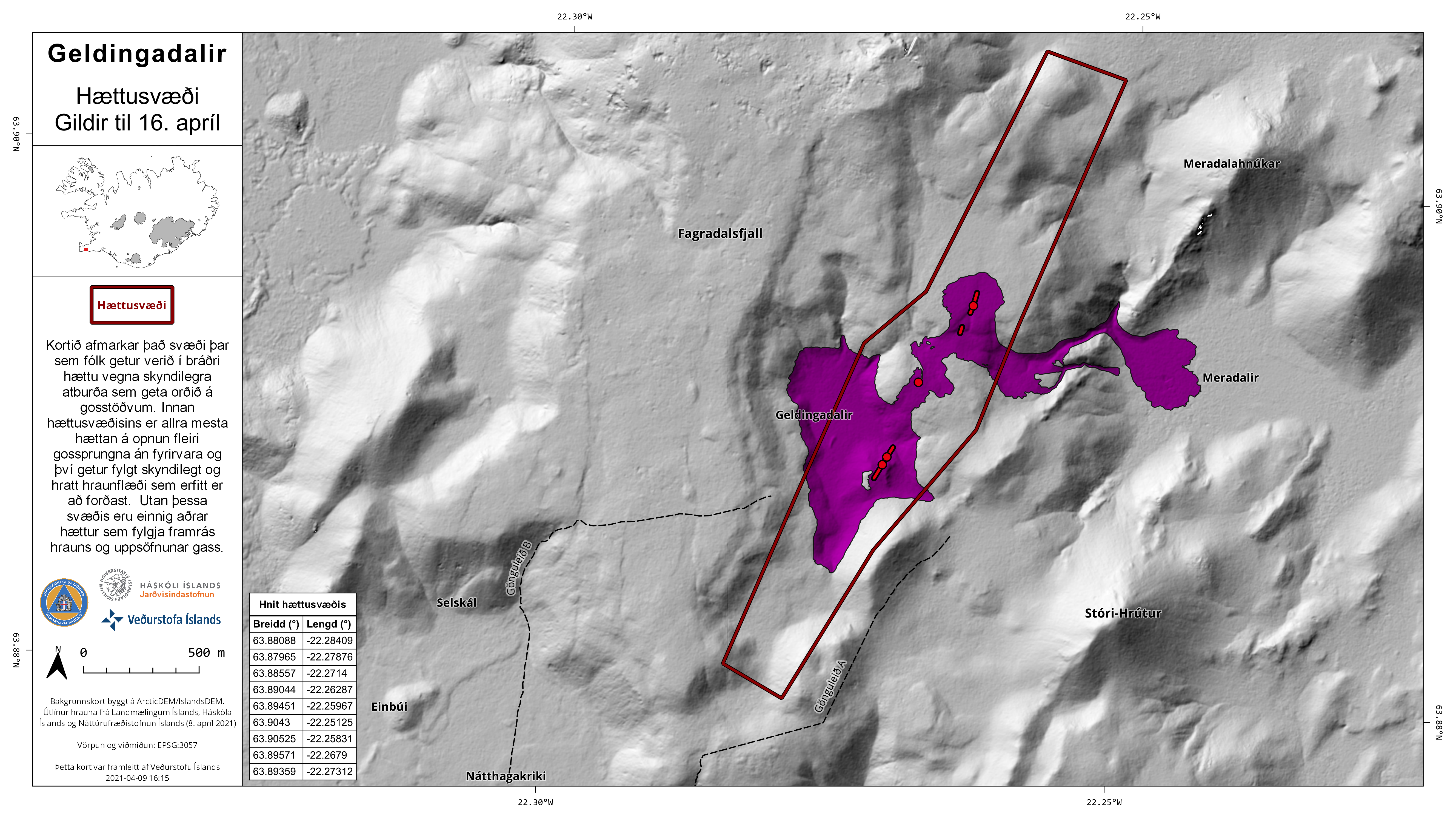
Icelandic Met Office released this map and press release (in Icelandic only) about the risk new fissures can open up both north and south the the current craters that are erupting. This page is updated regularly so if you are looking at this later than 9 to 10 April 2021 you might have to look for this information.
The new area that has a risk of new fissures opening up without warning. Copyright of this image belongs to Icelandic Met Office.
The map shows the area that is now at risk of new fissures opening up without warning.
Update 10-April-2021 at 15:20 UTC
Around 03:14 UTC on 10-April-2021 fissure number 4 did open up between fissure number 2 (5-April-2021) and fissure number 3. The eruption from this crater doesn’t seem to be large but it did happen under a new lava that had flowed over that same area few days before from fissure 2. In fissure/crater 1 the amount of erupting lava did drop a little just before the new eruption.
I am noticing that it seems new fissures are opening up more frequently then before. This seems to have changed after opening up of fissure 3.
Timeline of fissure openings so far.
1st fissure 19-March-2021
2nd fissure opened 5-April-2021
3rd fissure opened 7-April-2021
4th fissure opened 10-April-2021
Time period between new fissures opening up currently seems to be 3 to 4 days. I suspect that this is going to change soon and it is possible that new fissure that opens up might get larger as the eruption goes on. There seems to be phase in this eruption that is happening in Fagradalsfjall mountain. I am not perfectly sure what that phase is now since I’ve never seen this before and I don’t have any data on this type of eruption behaviour from other volcanoes outside of Iceland. That I know of.
This is a short update of the activity in the eruption in Geldingadalir valley (former, as the valley has now filled up with lava or close to being filled with lava). The eruption is taking place in Krýsuvík-Trölladyngja volcano system. The eruption has been stable all week. On Sunday 28-March-2021 other side of the craters that had built up collapsed into the lava stream that has formed below the erupting craters. Both craters are now about equal erupting size.
The lava that is now erupting is primitive Tholeiitic magma based on the chemical analyse from University of Iceland. That report can be found here (pdf).
Both craters are unstable and often suffer a collapse and rock slides and that often changes their look suddenly and drastically in a moment.
Icelanders continue to act like idiots in front of the web cameras that show the eruption online (I think all of them). The Rúv web camera is a large structure there that is easy to avoid (with solar panels and everything).
Lava boiling is a common occurrence that often breaks up through the newly formed crust in the new lava field. This happens without warning and often reshapes the lava field in a instance.
Spatter activity in the eruption craters often drops but the flow of lava seems to be stable based on the web cameras and observation reported in the news by volcano scientists according to the latest news I was able to find.
It is unclear when lava is going to start flowing out of Geldingadalir valley (former). It might start to happen this weekend or by next week.
Based on what I am observing on the web cameras at the writing of this article. A collapse might happen in the erupting crater on the right side on the screen (I don’t know what is north and south on the web camera). When that or if that happens is impossible to know, but the whole structure that I am seeing doesn’t look that stable when I write this article.
At the writing of this article a large collapse took place in the erupting crater on the left side on the camera. Resulting in block of the erupting vent and resulting in a lot of spatter activity as a result as it clears it self of the rock that fell into it.
Currently there are no signs of this eruption about to end. This eruption might go on for a long time. Next update about the eruption in Geldingadalir valley (former) should be on 9-April-2021 unless something major happens in the eruption.
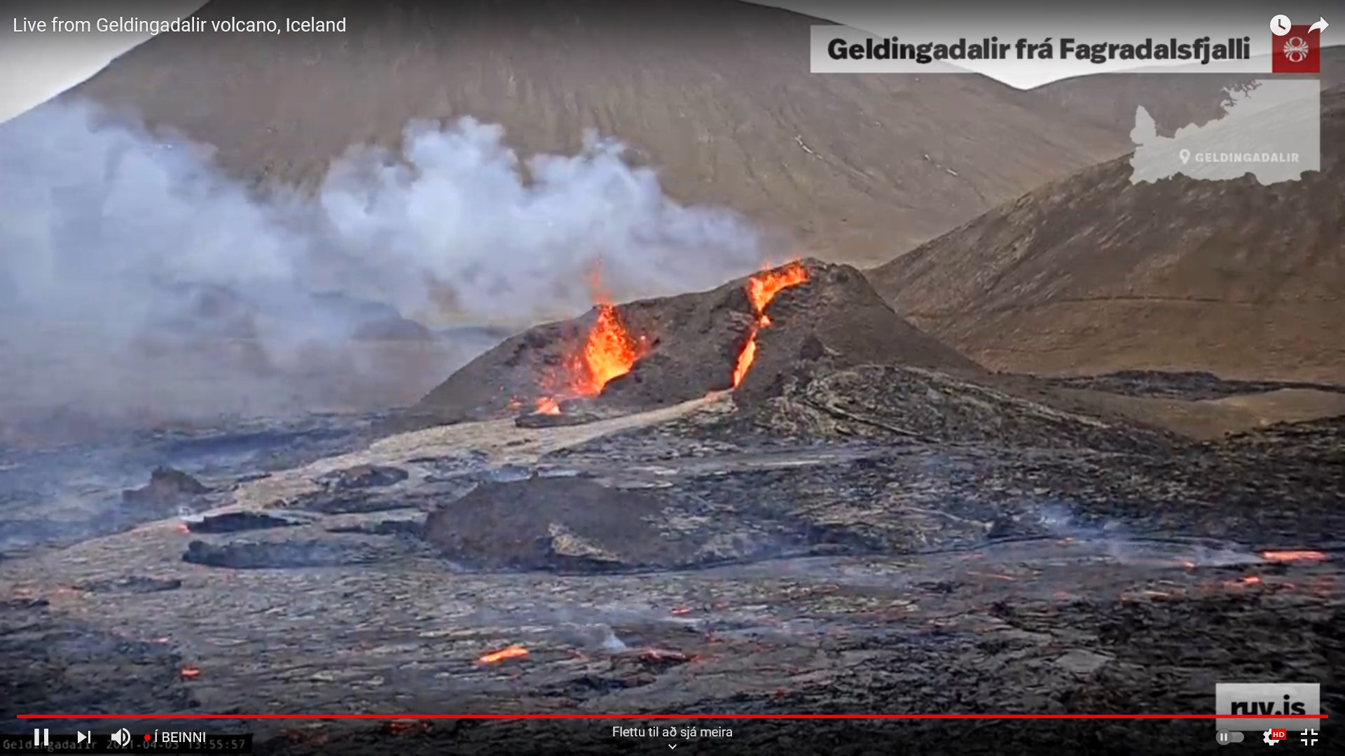
Update 14:12 UTC on 3-April-2021
The eruption craters at 13:56 UTC on 3-April-2021. Copyright of this image belongs to Rúv. From Rúv YouTube stream of the eruption.
There is now in the northern crater (right side on screen?) a small lava fall. Its not big but it is few meters high. There are variations in spatter activity and the whole crater structure remains unstable. There are many collapses and changes now over one day.
Donations
Please remember to support my work with donations. It helps me keeping everything going. Thanks for the support. 🙂
Cloudflare
I have now added Cloudflare to this website. That should prevent any problem with using it when a large spike in traffic happens as was the case when the eruption in Geldingadalir valley first started.
Advertisements
I re-applied to Amazon Associate accounts and that is now active but my website has to make a sale in next 180 days to make that permanent again. This rule also applies to old accounts. If you shop from Amazon using the Amazon banners (United Kingdom, United States, Germany) gives me a little extra income.
This is a short article about the eruption in Geldingadalur. The volcano that is erupting continues to be Krýsuvík-Trölladyngja volcano system. This might change at later date. This article is written on 22-March-2021 at 17:30 UTC.
The eruption is now mostly just in one crater. There is some activity in two other craters but it seems to be getting smaller as the eruption goes on.
This eruption is tiny and one of the smallest eruption observed in Iceland.
There is risk of new eruption opening up once this eruption ends or starts to get close to ending.
There is a fissure in the ground on the right side of the main crater (as seen on the web camera). A lot of volcanic gas comes from that fissure but no eruption has taken place so far.
There has not been any noticeable deflation according to GPS data from today (22-March-2021).
The main crater is now estimated to be 30 meters high but it is unstable and collapses often.
The lava is estimated going to fill Geldingadalur valley in 10 to 14 days if the eruption continues this long.
Earthquake activity has almost stopped on Reykjanes peninsula after the eruption started. Once the eruption stops earthquake activity might increase again.
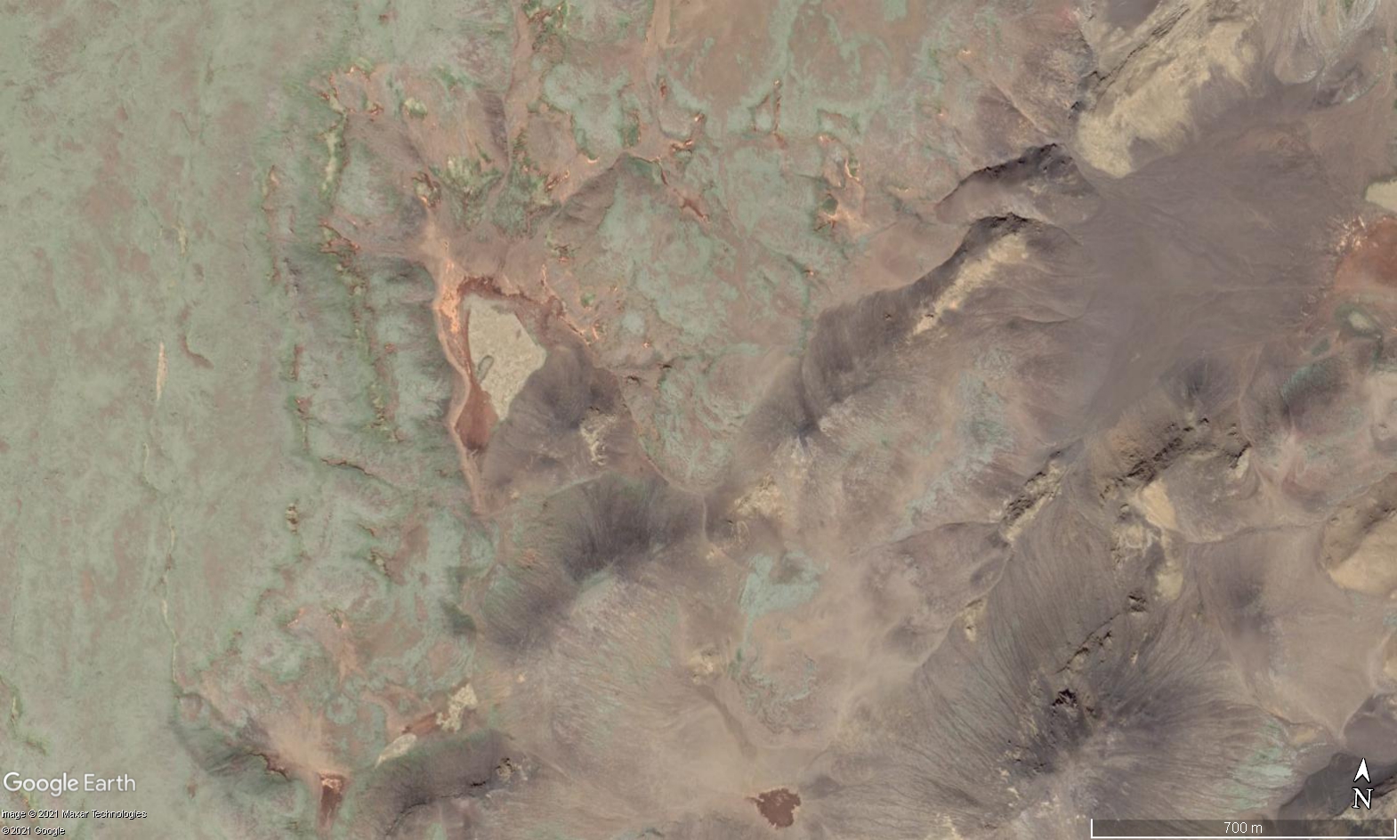
This is a image from Google Earth and shows Geldingadalur valley that is now being filled slowly with lava. Copyright of this image belongs to Google Earth/Google and other companies that Google has made this image available with its Google Earth program.
The last eruption period on Reykjanes peninsula lasted from the ~700 to the year ~1400. It can be estimated that current eruption period that has now started on Reykjanes peninsula is going to last until the year ~2400 to the year ~2600. During this time shortest time between eruptions is 1 year but the longest time between eruptions might be up to 10 years. How this going to be exactly is a big question but this estimate of mine is based on the limited historical data that I have read somewhere (I no longer remember where that was).
According to the evening news on Rúv the lava and magma that is now flowing into the valley of Geldingadalur is around 1200C and is a primitive magma of Tholeiitic magma series (Wikipedia). The source of this eruption is a magma chamber with the depths of 17 km to 20 km and the origins of the magma it self is far deeper into the hotspot below Iceland. This magma has a lot of CO and CO2 gases that are highly dangerous. There is also a lot of SO2 gas in the eruption and that is dangerous gas.
News in Icelandic about this
Since the eruption is now in stable activity I am going to limit update to if anything major happens. Next update about the eruption should be on Friday 26-March-2021. Other activity in Iceland is going to be reported as normal if anything happens.
Donation
Please remember to support my work with donations. Google Adsense remains limited on my website and I don’t know when it might get back to normal. Thanks for the support. 🙂
Article updated at 18:32 UTC. New web camera added. Article updated at 20:50 UTC. Web camera information updated. Article updated at 23:57 UTC. Information added about the eruption.
Cookie acceptance
We use cookies on our website to give you the most relevant experience by remembering your preferences and repeat visits. By clicking “Accept”, you consent to the use of ALL the cookies.
This website uses cookies to improve your experience while you navigate through the website. Out of these cookies, the cookies that are categorized as necessary are stored on your browser as they are essential for the working of basic functionalities of the website. We also use third-party cookies that help us analyze and understand how you use this website. These cookies will be stored in your browser only with your consent. You also have the option to opt-out of these cookies. But opting out of some of these cookies may have an effect on your browsing experience.
Necessary cookies are absolutely essential for the website to function properly. This category only includes cookies that ensures basic functionalities and security features of the website. These cookies do not store any personal information.
Functional cookies help to perform certain functionalities like sharing the content of the website on social media platforms, collect feedbacks, and other third-party features.
Performance cookies are used to understand and analyze the key performance indexes of the website which helps in delivering a better user experience for the visitors.
Analytical cookies are used to understand how visitors interact with the website. These cookies help provide information on metrics the number of visitors, bounce rate, traffic source, etc.
Advertisement cookies are used to provide visitors with relevant ads and marketing campaigns. These cookies track visitors across websites and collect information to provide customized ads.