This is a super short update. Since there’s too much happening at the writing of this article for me to write anything useful about current situation.
There’s a super dense earthquake swarm happening north-west of Grindavík town. There’s also an earthquake swarm north-east of Grindavík town.
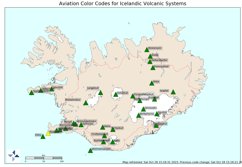
Almannavarnir have declared danger level for Reykjanes volcano and Grindavík town.
There’s a lot of earthquakes with strong magnitudes. Useful list is not possible at the writing of this article.
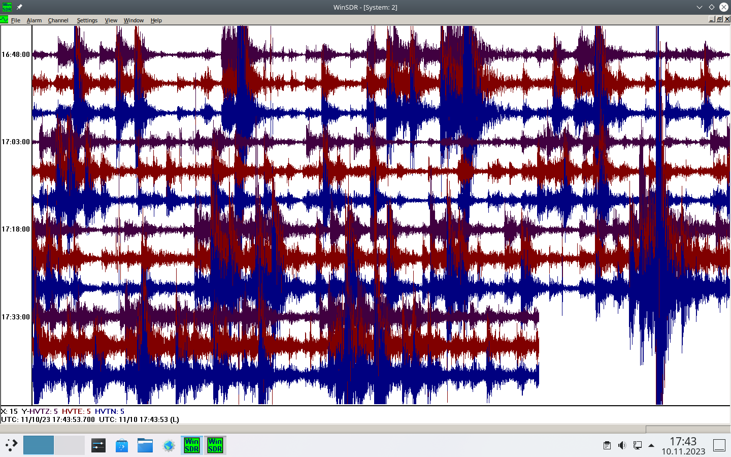
Dense earthquake activity at distance of 187 km.
This is what I am recording at the distance of 187 km from the source at Reykjanes peninsula. This is the most dense earthquake activity I’ve ever seen.
This is a short article. It might get outdated quickly.
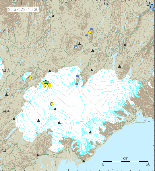
Around midnight of 9. November 2023 an strong earthquake started close to Þorbjörn mountain, in the same area that has been having an earthquake and dyke intrusion since 25. October 2023. At the writing of this article, the largest earthquake had a magnitude of Mw5,0 and with a lot of smaller earthquakes taking place.
Strong earthquake activity in Reykjanes volcano. Copyright of this image belongs to Icelandic Met Office.
It is unclear if this earthquake activity is the start of the eruption or just normal inflation related earthquake activity. The magma is still at depth of 5 km. If it has started to move upwards trough the crust, it is going to take several hours to reach the surface. That means nothing might happen on the surface until late tomorrow or on 10. November at the earliest. Depending on how quickly the magma goes up through the crust.
I’ll post updates tomorrow if anything more happens.
This is a short update and this information can go out of date quickly and without warning.
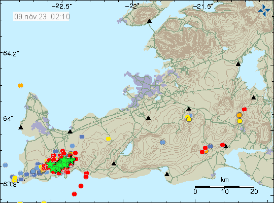
Earthquake activity continues in Svartsengi and close to Þorbjörn mountain. This earthquake activity is either tension earthquakes because of the dyke on either side (north-east and south-west) or in the dyke it self.
Inflation in Svartsengi and nearby area is extremely high and has been increasing much as 10mm a day in last few days.
There has been magma building up in the crust in the Reykjanes volcano since at least year 2020. It might have started few years earlier at more depth, but that is unclear.
There’s a risk of large eruption in this area, that might go on for few months in the worst case.
Largest earthquakes so far have had the magnitude of Mw4,7. Larger earthquakes remain a possibility.
It is impossible to know when a eruption starts or if it starts. But the likelihood of an eruption is extremely high.
Morgunblaðið reported that ground heat has been seen on thermal cameras. The news can be found about this here in Icelandic. There’s a YouTube video of this in both Icelandic and English (with more footage).
I’ll post new information about what is going on when it happens. As is, the situation does not change a lot from one day to another so I don’t have a lot to report on.
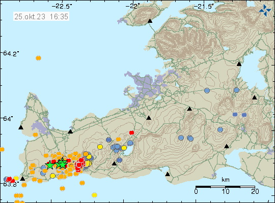
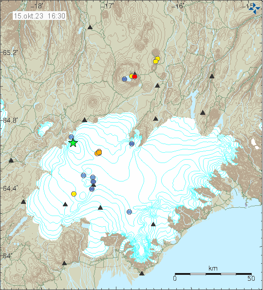
Today (31. October 2023) at around 08:00 UTC an magma movement was detected by Icelandic Met Office. This started an earthquake swarm that had a largest earthquake with magnitude of Mw3,7. The magma seems to be at depth of 1,5 km where it is the shallowest. Few days ago, that magma was at depth of 5 to 8 km. This change is rather quick movement of magma, that suggests higher pressure compared the magma that erupted in Fagradalsfjall volcano. This might result in a larger eruption when it happens. The inflation at Fagradalsfjall volcano, south part of it has not lowered. The only thing that has happened there is that earthquake activity has dropped to almost nothing. Earthquake activity has moved to western part of Fagradalsfjall volcano. Eruption also happening in Fagradalsfjall volcano should not be ruled out, but the events close to Þorbjörn mountain might delay the progress of that magma.
Earthquake activity because of magma movements in Reykjanes volcano. Copyright of this image belongs to Icelandic Met Office.
It is difficult to know what is going to happen next. But an eruption is highly likely, when and where is almost impossible to know even if GPS data gives good clues on where it might happen. This situation is complex and it is uncertain what is going to happen next with this activity in Reykjanes volcano and Fagradalsfjall volcano.
I’ll post information soon as I know something. A list of web cameras of Icelandic volcanoes can be found on the YouTube page that I set up a while ago.
The Reykjanes volcano has been placed on yellow warning level. This is because of sudden inflation that is now taking place north-west of Þorbjörn mountain. In slightly less than 24 hours the inflation did reach 30mm. This is the fifth time (as reported by Morgunblaðið) that inflation has happened in this area since the year 2020. This inflation now is a lot faster than earlier when this has happened.
The alert status for Reykjanes volcano is now yellow. Copyright of this image belongs to Icelandic Met Office.
This inflation in the Reykjanes volcano has the risk of creating stronger earthquakes in new locations on the Reykjanes peninsula and on the Reykjanes ridge in next few days to weeks. There is a ongoing inflation in Fagradalsfjall volcano and that has not stopped or slowed down since it started on 25. October 2023. It is not possible to know when or if an eruption in going to start in Reykjanes volcano, but how quickly this inflation is happening suggests that might happen. The location is not that good, if it erupts where the inflation is happening. The blue lagoon is nearby along with power plant and hot water energy plant in this area. Eruption in this location can result in major damage to infrastructure in this area.
Only thing that can be done now is to wait and monitor what is happening in this area.
Current activity is also complicated and might not behave in the same way as earlier eruptions did. Largest earthquakes at writing of this article have had magnitude of Mw3,5 and Mw4,5. Larger earthquakes can be expected without warning. There have been around 1000 smaller earthquakes at the writing of this article.
Earthquake activity in Fagradalsfjall volcano and Þorbjörn mountain. Copyright of this image belongs to Icelandic Met Office.
There is a good chance this events are not going to behave the same way as happened in earlier eruptions, because the location is little bit difference and that can result in a lot of change on what happens when magma pushes it self up through the crust. The earthquake activity close to Þorbjörn might be a mixed earthquake activity of tension breaking earthquakes and magma pushing it self up. GPS data doesn’t show any inflation close to Þorbjörn mountain at the writing of this article.
Earthquake activity is increasing in south part of Fagradalsfjall volcano, this is area in Nátthagi, Nátthagakriki and other nearby area. There is a dyke intrusion in that area and has been a while. That dyke intrusion might be about to erupt. There is a lot of uncertainty going on at the writing of this article. There is also a pattern of high and low in the earthquake activity, this has been the pattern in the earthquake activity before the earlier eruptions.
I’ll write updates about this activity as needed. It might take a while, since I always try to figure out what is going on before an article is written.
Yesterday (24. October 2023) at 22:19 UTC an earthquake with magnitude of Mw4,9 took place in Bárðarbunga volcano north eastern part of the volcano. This time it was not in the caldera as is the most common location for this earthquake activity.
Earthquake activity in Bárðarbunga volcano. Copyright of this image belongs to Icelandic Met Office.
This is a inflation connected earthquake activity in Bárðarbunga volcano. This is the second earthquake this year that reaches magnitude of Mw4,9. There is no risk for an eruption in Bárðarbunga volcano at current time.
Yesterday (14. October 2023) an earthquake with magnitude of Mw3,6 took place in Bárðarbunga volcano. This is one of many inflation earthquakes that have taken place in Bárðarbunga volcano since end of the eruption in 2015. This earthquake activity is going to continue for the next 50 to 100 years if nothing changes, but with rate of earthquakes getting lower as the time passes.
The activity in Bárðarbunga volcano. Copyright of this image belongs to Icelandic Met Office.
This earthquake activity is normal and won’t result in a eruption. This type of earthquake or larger happen currently every two to three months in Bárðarbunga volcano.
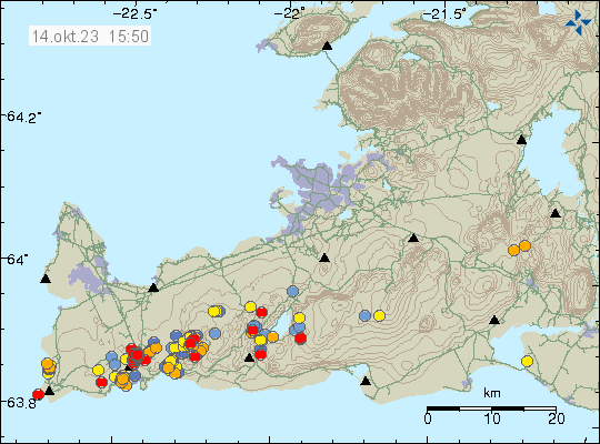
Icelandic Met Office reported today (14. October 2023) that an new eruption in Fagradalsfjall volcano or nearby is now expected to happen before or close to Christmas. After the end of the eruption on 6th August 2023 the inflation that has been happening is now faster then before earlier eruptions. At the writing of this article, an earthquake with magnitude of Mw2,7 took place north of Grindavík town and was felt in Grindavík.
Earthquake activity north of Grindavík town and in Fagradalsfjall volcano. Copyright of this image belongs to Icelandic Met Office.
In the last two eruptions, after the first eruption ended. There have been around ten months between eruption. That does not seem to be the case now. Since it seems that next eruption is going to happen at four to six months time. A half or close to it from when the last eruption took place. This situation is dangerous, because this means that an eruption can start without much warning and not a lot of earthquake activity. Icelandic Met Office advice is that people travel around and in Fagradalsfjall volcano carefully.
For the last few years I’ve been running a basic email postlist that seeks out new articles from this website few hours after I post them. Because of changes from mailchimp that I’ve been using I’ve made the chose to close down the postlist from next Saturday. I recommend that people find a RSS client to get updates when I post new articles about earthquake and volcano activity in Iceland.
Update 14th October
I have now closed down the email poslist and deleted my mailchimp account (that I had been using since 2013). I only used the free version of the email since that was the only thing I needed. If I ever create a new email postlist. It has to be a solution that I can run my self. If that happens is I don’t know yet. Since technical solutions can be difficult when it comes to email subscription lists.