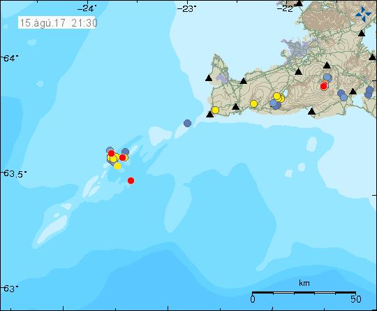
Yesterday (14-August-2017) and today (15-August-2017) there has been a minor earthquake activity around 60 km off the coast on Reykjanes ridge. The area has a volcano (not named as such), but the area is often named after island named Eldeyjarboði.

The earthquake activity close to Eldeyjarboði on Reykjanes ridge. Copyright of this image belongs to Icelandic Met Office.
Largest earthquake in this swarm so far had the magnitude of 2,8 and other earthquakes have been smaller in magnitude. There is a chance this earthquake swarm might increase in magnitude and number of earthquakes. The Icelandic Met Office SIL network has slight problem properly locating earthquakes at this distance (~60 km). Last eruption in this area took place on 1.May-1783 when a new island called Nýey was formed, it vanished few weeks later. Information on Wikipedia in Icelandic only (second language is Danish) can be found here.
Donations
Please remember to support my work with donations. This month like any other month in 2017 and until the end of the year 2017 I am really broke. First part of 2018 is going to be better but I won’t get rid of this being broke until July-2018 and after that I should be free of my current money problems. Thanks for the support. 🙂

And now a swarm on Reykjanes Peninsula as well. 5km and below though. Something is definitely brewing in that entire area…
Looking tectonic so far but that can change:
http://hraun.vedur.is/ja/drumplot/drumplot/san_highpass_2.0.png
Is this what’s causing earthquakes in Katla at the moment, as didnt the last time Reykjanes last month had a swarm with stronger earthquakes the similar thing happened?
Yes, but we have lava at 5km depth in cracks in the region and these earthquakes now seems to move closer to the surface.
We’ll have to see what happens here…