
This article is going to be updated as needed.
Since yesterday (30-September-2016) Katla volcano has been quiet. For the last 24 hours no major earthquakes (above magnitude 3,0) has happened. Only few minor earthquakes have happened in this period and almost all of them where less then magnitude 2,0 earthquakes. Only two earthquakes had the magnitude above 2,0 and none above 3,0.
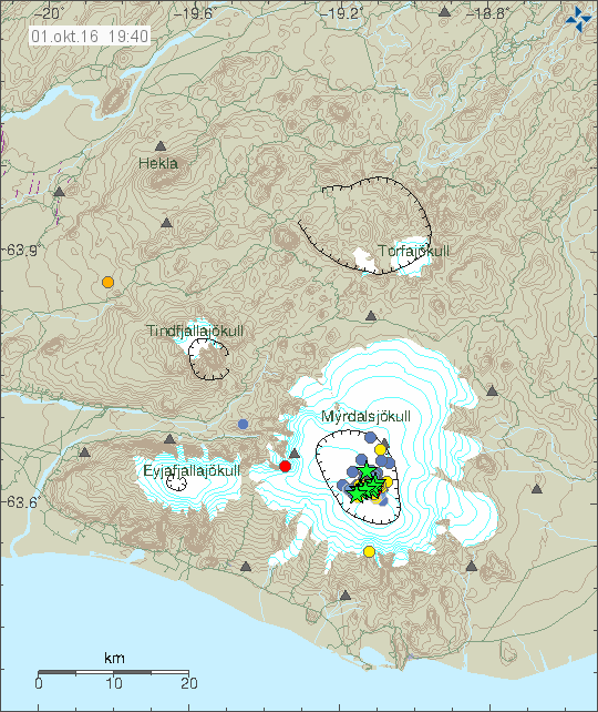
The earthquake map of Katla volcano for the last 48 hours. Copyright of this image belongs to Icelandic Met Office.
Conductivity in Múlakvísl glacier rivers continues to be high and the glacier river has unusual low amounts of water in it. When this is written the value has dropped down to 104 µS/cm from the high of 221 µS/cm. The folk tale for this are is that sometimes Múlakvísl glacier river goes dry just before an eruption. I don’t know if that phoneme gets confirmed or not when a eruption starts in Katla volcano.
The reason for this earthquake activity in Katla volcano is due to magma trying to push it self to the surface from depth. If experience is anything to go by it is clear that current activity is not over, even if there is a drop in activity at the moment. I’ve seen this type of drop in activity before, few hours before the eruption (the first one) in Eyjafjallajökull 2010 and in Bárðarbunga volcano 2014. The lack of earthquake can have many reasons behind it. The magma might now be flowing without a resistance, the pressure has equalised for the next few hours (if that time is not running out already) or something else. Currently all that can be done is to wait and see what happens next.
Streaming web cameras of Katla volcano
Here are two streaming web cameras for Katla volcano.
Rúv live web camera of Katla volcano.
Live from Iceland web camera of Katla volcano.
Storm warning for Iceland Sunday to Monday
On Sunday and Monday there is going to have strong storm in Iceland with wind gusts up to 40m/s in south Iceland to start with. Heavy rain is going to follow this storm according to the weather forecast at the moment.
Article updated at 22:16 UTC. Links to live cameras of Katla added.
Were these two up by the time you wrote the article Jon?
Saturday 01.10.2016 05:01:02 PM 63.618 -19.1 0.1 km 2.6 99 4.3 km N of Hábunga
Saturday 01.10.2016 04:23:20 PM 63.646 -19.346 0.0 km 2.2 99 4.8 km W of Goðabunga
or are they new?
Yes, I knew about those two earthquakes when I wrote the article.
Thanks Jon for this update.
Updated German information see below:
http://www.lukas-gawenda.de/erdbeben-am-vulkan-katla-auf-island/
List of links with reliable sources and inforamtion:
Earthquakes:
http://www.lukas-gawenda.de/island-aktuelle-erdbeben/
Volcano status:
http://www.lukas-gawenda.de/island-aktuelle-vulkanausbrueche/
Realtime information via Twitter:
http://www.lukas-gawenda.de/aktuelles-aus-island/
Alright, I’ve made a decision.
Please contrite to the discussion, not just post links. Next time I see this (comments with a lot of links to your website) the comment is going straight to the trash bin. You can have a link to your website in your name as you already do. That should be enough for you and anyone else.
If you are posting links to science papers that is fine or other science website with information.
Well Lukas, where is the link to Jón’s website on your site? The way you are promoting your own site is beyond polite behaviour.
Jón, thank you for the great update!
Hear, hear. I agree, Jen, on all counts.
There are two links to Jons site 🙂
I agree Jen! at least I post the link on my facebook page since I dont have a working website.
Please see above – there are at least two links on my site reffering to Jons great website.
Great information here.i am off to iceland for the first time on wednesday so following this page with great interest!
The rifting of Bárðarbunga also involves Katla.
No. It doesn’t. Katla and Bárðarbunga volcano fissure swarm don’t touch at all. Katla is more in line with Grímsvötn volcano system, as the sit on the same fissure swarm area, but the fissure swarms don’t touch each others far as I know.
Looks like there is a lot of activity all over Iceland right now. Whats up with this for instance the swarm of 1+s in the Langjökull region
The Langjökull volcano earthquake activity is just earthquake activity. Far as I know there isn’t anything happening in that volcano.
Jon these last 4 are all outside the area that the swarm was taking place in but could they be proof that there is still some room for inflation around Katla?
Saturday 01.10.2016 23:29:00 63.590 -19.699 5.7 km 0.9 90.01 12.1 km WNW of Skógar
Saturday 01.10.2016 22:02:57 63.604 -19.408 5.1 km 1.4 67.8 8.8 km WSW of Goðabunga
Saturday 01.10.2016 21:53:13 63.721 -19.278 6.8 km 1.0 32.77 9.1 km N of Goðabunga
Saturday 01.10.2016 21:52:00 63.689 -19.332 7.7 km 1.2 31.14 6.8 km NW of Goðabunga
Some of those earthquakes are errors, or at least not properly located. The earthquake at Skógar is a interesting one. It might just be Eyjafjallajökull volcano complaining about Katla volcano activity.
Or maybe cheering for big brother??
I normally dont post but thats funny!
Another Jen? 😉
Ya ha. Im following this thread as im very interested in volcanism in general. I used to want to be a volcanologist as a child. I have a strange facination with them lol
I actually also amazed at how little we know about the relationship between the eyjafjallajokull volcano and katla. In this day and age with all that we do know we cant disginguish the exact relationship between the two
Haha, I totally feel the same. What’s in a name 😉
Conductivity in Múlakvísl glacier river has again gone up to 211 µS/cm.
I agree it could be a calm time before eruption, but I have a question: if this is the case why no tremor has been detected indicating magma is aproaching to surface?
Best from Chile
This seems related to your observation about increased conductivity and decreased river volume:
https://www.researchgate.net/publication/241272657_Real-Time_Monitoring_of_Glacial_Rivers_in_Iceland
When I’m looking at the ve – god seismogram right now, the bottom few rows look like there is always a slight background tremor, there is almost no white space between the lines but the ones at the top have well defined white space, is that possibly harmonic tremor?
Or wind
Ah thank you for the clarification, I do recall someone mentioned that bad weather may be inbound.
For Katla caldera tremor, it’s better to look at the fairly new Austmannsbunga (AUS) station, on the northern edge of Katla caldera. Just a recommendation!
(GOD picks up most of the activity at Katla, for certain, but is located on top of Godabunga, which really is a separate volcanic system.)
I am not any good at reading these tremorgraphs but i do see that it is increasing in volume as we speak, “http://hraun.vedur.is/ja/oroi/aus.gif” it can be seen here. Does this mean anything, maybe some harmonic tremors inbound?
bad weather
oh yea that’s right, thanks
There was quite a burst of tremor on the 30th to the 1st, what chances a glacial flood prior to eruption given the reduced flow in Múlakvísl Jon?
Is this scaremongering? It popped up in a search.
http://www.express.co.uk/news/science/701489/Yellowstone-fears-violent-eruption-devastation-volcano?_ga=1.235648514.2099853783.1473565906
Yes, this is scaremongering. The Sunday Express has to write about something so they just make it up when don’t have anything.
Thank you Jon for updating the current situation in Katla. I found this site accidentally while planning our trip to Iceland in mid-October. We’re going to stay a couple of nights in Vik, so naturally it feels very special to read now about what’s happening inside the volcano. Jon – or any local – could you please suggest us a link or the best way to be updated about latest Katla information while we are on the road? Keep up with this great and informative site, Jon, and greetings from Finland
Alerts are going to be on the following websites.
http://www.almannavarnir.is/
http://www.ruv.is/
I’ll also post rapid updates once an eruption sequence is confirmed. Local warning is also to be issued in Vík í Mýrdal and nearby area. Please be advised that the police says that people should not sleep in tents out in the open south of Mýrdalsjökull due to sudden flood risk if an eruption starts suddenly and without warning. It takes time to clear the area and the flood can be down from Mýrdalsjökull in as short time, no less then 2 hours after an eruption starts.
Please also be advised that the weather in Iceland can be rather bad during the month of October in Iceland. A lot of storms with strong wind.
I think they need to get a life
Sunday
02.10.2016 14:01:26 66.278 -17.540 13.6 km 3.1 99.0 18.4 km NE of Flatey
http://en.vedur.is/earthquakes-and-volcanism/earthquakes/tjornes-small/
Jon what do you think is going on in Katla at the moment?
Nothing at the moment. Nobody is sure what is going on in Katla volcano.
Thanks Jon just a waiting game then.
The department of Civil Protection closed the road to Sólheimajökull glacier yesterday adn the road is also closed today. It is forbidden to walk onto the glacier. However, only a few small earthquakes have been detected in the Katla area in the last 24 hours.
According to South Iceland police the situation will be assessed again on Monday.
People are also asked to not camp anywhere between Skógar to Dyrhólavegur and not from the east edge of the town of Vík to Kúðafljó river.
No quakes over the magnitude of 3 have been detected in Katla since Friday.
http://icelandmonitor.mbl.is/news/nature_and_travel/2016/10/02/roads_close_due_to_katla_eruption_warning/
Hi Jón,
The tremor line that we have to follow for see if an eruption starts is the red one, isn’t it? In the Hvo and Aus stations is going a little bit up but is it because of the weather? Thanks for your fantastic work.
Yes, that is correct. If an eruption starts the red line on the tremor plots is going to move in the same direction as the other colours. Weather can affect this if a strong storm goes over Iceland that is going to be the case for the next 24 hours, but if an eruption starts in that time period the eruption tremor is going to be a lot higher in amplitude then the weather noise.
This is an extremely low frequency signal. 0.5 Hz is a period length of 2 seconds. It must feel strange to be standing close to a very high red signal. Is it wind that make the blue one raise sharply at the moment.
You are looking for a signal that looks something this, those signals are from Grímsfjall 2011 eruption and that was the largest eruption in 140 years in Grímsfjall volcano.
http://icelandgeology.net/?p=960
Interview with Pall Einarsson on understanding the current activity:
http://www.ruv.is/frett/skjalftarnir-minna-a-undanfara-eldgosa
This article does not translate well in Google. In the paragraph 3rd from the bottom, I believe (not sure) he is saying that they hope to distinguish between harmonic tremors and magma quakes in order to predict an impending eruption indicating that the picture may not be perfectly clear. I know Katla can give very little warning as well and just pop without a lot of harmonic tremors, correct?
Far as I know all the or most of the earthquakes that have happened in Katla volcano long-period earthquakes. Suggesting they are result of magma pushing it self (forming cracks) in the upper layer of the crust.
You can read more about those earthquakes here.
https://volcanoes.usgs.gov/vhp/earthquakes.html
It’s twilight in Iceland and the Katla cam has gone black. I am assuming this is because he cam lens is covered in wet snow.