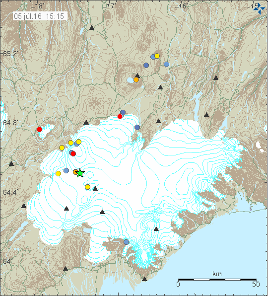
Today (05-July-2016) at 05:56 UTC an magnitude 3,4 earthquake took place between Bárðarbunga and Grímsfjall volcanoes.

The green star is the magnitude 3,4 earthquake between Bárðarbunga and Grímsfjall volcano. Copyright of this image belongs to Iceland Met Office.
This earthquake suggests that an complication is on the way. The question here is if an interaction between Bárðarbunga volcano and Grímsfjall volcano is on the way. Since both volcanoes are preparing for an eruption. [Speculation!] All that I get from my models (in my mind, since I don’t have the computer power or the skills to make them PC friendly at the moment) is confusion. At worst a magma dyke from either Bárðarbunga volcano might enter Grímsfjall volcano or an dyke might come from Grímsfjall and enter Bárðarbunga volcano (hint: A result of either of such event is rather catastrophic eruption, even if just for a short time). What can also happen is nothing, just earthquakes and nothing more. However, increase in the earthquake activity at this location suggests that no such luck is on the way. When and if such event happens is impossible to know, what can be done is to keep monitoring, day and night. This is going to happen the when and the way it wants to happen, all that can be done as humans is to wait and see. [/Speculation!]
Donations
Please remember to support Iceland Geology so that I can keep writing this articles (so I can buy food to keep writing). Thanks for the support.

Is this near the Gjalp fissure?
This earthquake is too far west compared to Gjálp location. I can’t find a good map for this.
On this map you can turn levels on and off
Turn off the 1995 to 2016 level and you will clearly see the Gjalp fissure marked . Today’s M3.4 quake is on this map just to the west of the fissure
https://vatna.cartodb.com/viz/2c9d8c08-c2b6-4efa-afad-d4f0b078b025/public_map
great site man!
Wednesday
06.07.2016 03:06:23 63.897 -22.109 5.3 km 2.8 99.0 2.4 km WNW of Krýsuvík
Please remember to donate. I just had to buy news shoes and it blew a hole in my budget (sight). I’ve also not been able to buy new hard drive for my PC and a PSU for my main earthquake computer yet (annoying) or go to the dentist as I need to.
Jon, if you remember when the holuhraun eruption was ending you predicted it may push to the south, whilst I predicted west, as borehole strain gauge at Hekla were mirroring bardarbunga eqs.
Now it seems that could be right in your part. Correct me if I’m wrong, but was there a subglacial lake around the area of these latest eqs?
Not far from this location are Skaftárkatlar cauldrons. They have been growing bigger in the last year according to latest measurements. The reason for that is increased ground heating from magma in the Hamarinn volcano.
Now there’s something you don’t see very often; a small swarm in Þeistareykir!
Earthquakes do happen in this area once in a while. This activity now is slightly deeper then normal. I don’t think it is nothing to worry about for now, however due to recent history of dyke activity it is clearly something to watch.
Please remember to donate to support me. Not getting to the dentist is not fun (they cost awful lot of money. I hate this system as it is today.) :-/
Thanks for the support. 🙂