
This is going to be short update on the activity in Tungnafellsjökull volcano. I just don’t have the time to write long article about it, doing so takes up to two hours to write. A time that I just don’t have at the moment due to work (and school) tomorrow.
Today (23-September-2015) there has been a sharp increase in earthquake activity in Tungnafellsjökull volcano. Largest earthquake so far had the magnitude of 3,0. Other earthquakes have been smaller in magnitude. Most of the earthquakes that have been taking place are shallow, but all of them (at least that appear on my geophones) are appearing to be long-period earthquakes. Suggesting that magma created them, rather than tectonic forces in the crust.
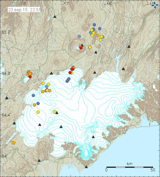
The earthquakes in Tungnafellsjökull volcano. Copyright of this image belongs to Iceland Met Office.
It is the official view of the Iceland Met Office that this activity is due to tectonic stresses in the volcano, due to adjustment of Bárðarbunga volcano. This is true, that is not the whole story in my view. Some of the earthquakes taking place in Tungnafellsjökull volcano are due to tectonic adjustment of the crust (stress changes). What adds complexity to this image is the fact that magma is involved in Tungnafellsjökull volcano, the problem that since there are no documented eruptions from Tungnafellsjökull volcano, it’s impossible to know for sure what happens before an eruption in it. If the current influx of magma results in an eruption is difficult to say for sure, at the moment I don’t rule it out. It is my view that there is now more chance, rather than less of an eruption in Tungnafellsjökull volcano.
Jon you kinda forget one thing. The helicorders are not so close. And when you go further out, the signal amplitude generally weakens and gets that prolonged teleseismic look, like long period events.
You should have known that.
Since the signals on the closest VON station are looking more tectonic.
I would go with IMO on this one. But given some past quakes, there is magmamovement under Tungna.
This is not the first time we’ve seen unrest in the Tungnafellsjökull area lately.
Given the current situation, shouldn’t IMO consider setting up a seismometer closer to the area?
I can still see over a good distance ( up to 240 km) what type of earthquake took place if the wave form is clear enough. That is not always the case depending on the fault breaking relative to my geophones location. Not all of the earthquakes are long period earthquakes, most of them are tectonic in nature.
Current activity reminds me a little bit of Eyjafjallajökull volcano. The different is that Tugnanafellsjökull volcano shape is more like Hekla volcano (based on images).
Strongest EQ of this Tungnafellsjökull event so far occurred at 04:09.
Still not manually checked, but I’d say it is atleast M3,5, maybe <4.
http://hraun.vedur.is/ja/alert/2015/sep/24/008.html
Oops, that will be >4.
Also, calling this an ‘event’ is maybe not the correct term.
Apparently, I can never write a comment without making some spelling error or forgetting something.
A star almost certainly, but a 4+ definetly not. Probably not even over 3.5.
Tho it is true that depth plays a role. The signal is generally stronger on the tremor plots, but is not an M4+ strong.
You are probably right. I happened to wake up and check the early warning maps right after the EQ was registered, it wasn’t even showing in the usual tremor plots yet.
Basically, the only data I based my hasty judgement upon was the number given in the early warnings ‘mag.’ column: yesterday’s 3.0 had 473, and the EQ this morning a staggering 1170.
All in all, very scientific of me!
Tho I do wonder, since ASK and KRE signals look a bit different. Around 10x stronger signal on a different frequency range, so probably it could be a bit deeper than the 0.1km as yesterdays M3, atleast 1.5km or deeper, or something else is damping the signal if its very shallow.
Lets wait and see first. 🙂
So much for the exhilarated comment-bombing.
M2.6 ?!
I’ll get my hat.
It was an M3 at least, because the signal was overall stronger than yesterdays M3, and it was at the same depth and location. Thats a fault on the IMO side.
It juuussst didn’t make headlines. Let’s say it’s a hoax.
That should read but only just. Manual check completed.
Jón, I really comment you for finding the time to research and write in circumstance where you are under such intense time pressure. Many thanks for your efforts.
The above should realy “I really commend” not comment!
Here’s the abstract from a very interesting and informative article that may help shed light on current events.
“The volcanic system of Tungnafellsjökull lies in the Central Iceland volcanic zone near the center of the hot spot and the triple junction where the Eurasian Plate, the North-American Plate and the Hreppar Microplate meet. Holcene activity in the Tungnafellsjökull system has been very low, only two small lavas are associated with the system. The Tungnafellsjökull fissure swarm is rather short and wide compared with fissure swarms of other volcanic systems at the divergent plate boundary, 40 km long and 20 km wide. Earthquakes are not common, with usually fewer than 10 being registered per year. Due to these facts, it came as a surprise when InSAR measurements detected movements on faults in the fissure swarm of Tungnafellsjökull during the Gjálp
eruption in Vatnajökull in 1996 at a distance of around 37 km from the eruption site. Ground check in 2009 and 2010 revealed evidence of recent movements on faults in the area in the form of fresh sinkholes and fractures, some of which had moved as recently as the spring of 2010. Fresh sinkholes are known to form mostly during faulting events. They are formed when surface soil is washed into underlying, widening cracks in the bedrock. Based on earthquake data and InSAR images these fault movements occurred during three tectonic events, in October 1996 during the Gjálp eruption, in August 2008 and in November 2009. The events are expressed by increased seismicity in the Tungnafellsjökull area, both in terms of number of recorded earthquakes as well as rate of seismic moment release. The earthquakes were all small. The total released seismic moment is equivalent to that of a single earthquake of magnitude 3.4. The widespread evidence of recent fault movements and the small magnitude of the earthquakes suggests that the fault activity is related to magma movements rather than tectonic faulting.”
From: “Evidence of recent fault movements in the Tungnafellsjökull fissure swarm in the Central Volcanic Zone, Iceland” – by Þórhildur Björnsdóttir and Páll Einarsson in JÖKULL No. 63, 2013, p. 17. Available freely online.
It is evident that the activity described in the paper is historically anomalous. I also infer that the EQ activity we have been seeing in the immediately recent period is anomalous relative to that described in the paper. The authors’ argument that the recent fissures and sink-holes require to be explained by magmatic activity in addition to tectonic seems to imply “watch this space” – though maybe for a long time!
Sorry, should have mentioned that the paper is about the same area as that in which the current earthquakes are taking place.
Good read. I guess we will just have to wait and see what this brings to us. More sinkholes,and cracks or even a small eruption in tunga or even barda himself having a blowout. This rifting event certainly involves not just one volcano
I’ve been keeping an eye on the http://baering.github.io/ site the last week or so. To my eye it looks like there has been three instances where there is a M2 to 3 quake at 5 to 10 km depth under Bardarbunga. Then there’s a 6 to 8 hour delay followed by a vertical line of quakes at Tungnafellsjökull.
Is this sort of delay common in tectonic stress transfer? Or does it take 8hrs for magma to move that distance?
Our friend “Tungna” has wake up of his little rest …
It’s a new age for Island… 🙂
Wake up? Not at all.
“Rolling in its sleep” would be the correct thing to say. 😉
Some localised tremorish signal appearing at VON.
http://shrani.si/f/32/13J/44EwrUx0/von.png
Hi! Can this be due the strong gale of the storm that is hitting Iceland?
This is due to a storm in Iceland at the time. The storm season in Iceland has started and tonight there is going to be storm passing over Iceland, it is going to pass over quickly with a lot of noise and strong winds.
Ok, so now there are a lot of EQs being registered at a pretty precise point down in South Icelandic fracture zone. Haukadalur and Saurbaer seem to be the closest IMO stations, but it’s pretty far from any volcano (closest would be Hekla).
What might be causing this?
This is part of SISZ. This are tectonic earthquakes, not volcanic. SISZ is a fracture zone.
The earthquake activity is appearing clearly on my Heklubyggð geophone and you can see the activity here.
http://www.jonfr.com/webicorders/tremoren.htm
http://icelandmonitor.mbl.is/news/nature_and_travel/2015/09/29/glacial_river_flood_under_way/
Thanks for posting that. It’ll be interesting to see how things develop.
I imagine that this could be related to the activity that we have seen recently east of Hamarinn, which is where the Skaftá cauldrons are.
Thx Mike!
IMO on their website on this topic:
http://en.vedur.is/about-imo/news/nr/3199
http://icelandmonitor.mbl.is/news/nature_and_travel/2015/09/29/scientists_study_glacier_river_flood/
Last sentence: “There is no doubt that this is a glacial river flood. The GPS station on the glacier has subsided and this happens when water empties out from the cauldron.”
We can see the subsidence ourselves here: http://brunnur.vedur.is/pub/vatnavakt/skafta/
This was always an event related to resurgence of a shallow body of high viscosity magma in my opinion,not that ,my opinion is worth anything.
the cauldron is falling faster in last hours… http://brunnur.vedur.is/pub/vatnavakt/skafta/ska2_cauldron_gps.html
I’m sorry for lack of update today. I was working until 18:00 UTC today and I just don’t have any energy to write anything.
Keep watch on the harmonic tremor. Glacier floods in this area are known to create disturbance in the volcano system that powers the hydrothermal systems under the glacier when the pressure drops. In current state that result might be interesting.
This night it fals even more: http://brunnur.vedur.is/pub/vatnavakt/skafta/ska2_cauldron_gps_all.html
vertical fall now…
here: http://brunnur.vedur.is/pub/vatnavakt/skafta/ska2_cauldron_gps.html
Almannavarnir @almannavarnir 13m13 minutes ago
Uncertainty phase declared due to the possibility of a fast rising flash flood in Skaftá, S-Iceland, 1/2
I think we just reach 10m fall since yesterday…
Almannavarnir @almannavarnir 3m3 minutes ago
2/2 The rate of subsidence is increasing progr. (9,8m), reflecting discharge from the lake. #Skaftarjokull
Gisli Olafsson @gislio 33m33 minutes ago
Scientists expect the glacial flood from #Skaftarjokull to occur late tonight #Iceland
tremors from the glacier flood already well visible: http://hraun.vedur.is/ja/oroi/grf.gif
Almost 42 metres now!
The flood has reached the first waterlevel-station “Skaftá við Sveinstind” in the morning!
http://vmkerfi.vedur.is/vatn/vdv_gmap.php
Click on the pin or choose in the list on the left –> graph.
Seemsto have stopped at 46.4. Either it has stopped or the measuring system is not working anymore as predicted by vedur.is could happen.
The GPS graphic just stop…
working again!
49.2! :))
Jon, no worries about not updating/writing articles all the time. In fact, I usually skip your article and go directly to the comments for the latest update 🙂
When this is over will the crater recover the lost metres over time or will it stay sunken, i.e for example 60 metres lower?
Skaftá River reaches 1000 m³/s with 5,35m waterheight now!
Experts from IMO awaits rising levels until Saturday morning.
And further: “Those floods can peak with 1500 m³/s”, they say.
The flow at Sveinstind is now almost 900 cubic meters per second and growing at the fastest pace ever measured.
This could be a big flood.
http://ruv.is/frett/hradasti-voxtur-sem-vid-hofum-sed
At the moment the water level is still rising. More than 1400 cubic meter per second at Sveinstind. Its near 1450 cubic meter per second. With a water hight near 650cm.
The Iceland Met Office make a note that this can be the largest water flood in this river from the time the Sveinstind station had been placed in 1971.
Experts are expecting this to be possibly the largest ever discharge from the eastern Skaftá couldron. Article in Icelandic: http://www.ruv.is/frett/haettustigi-lyst-yfir-vegna-skaftarhlaups
WOW!
Possibly the largest jökulhlaup ever measured from Eystri Skaftárkatli.
Read http://en.vedur.is/about-imo/news/nr/3207
Does anybody has moving pictures of the event?
http://www.utvarpsaga.is/frettir/3180-h%C3%A6ttustigi-l%C3%BDst-yfir-vegna-skaft%C3%A1rhlaups.html#.Vg14E2yhf4j
http://www.vulkane-islands.de/2015/10/01/bilder-und-videos-vom-gletscherlauf/
hi everyone . do you know any webcam in this area .
http://www.utvarpsaga.is/frettir/3180-h%C3%A6ttustigi-l%C3%BDst-yfir-vegna-skaft%C3%A1rhlaups.html#.Vg14E2yhf4j
This is the largest glacier run in the history of Iceland. 1930m / 3 per second date. (Since there are records) WHO IS JOHN ??????
I’m working 10 hours a day (when I’m not in school learning Spanish) in a slaughterhouse at the moment, it is going to be like this until at least middle of October, the work is until end of October. When I come home I just don’t have the energy to write anything. I’m going to write about this on Saturday (if I have time) or Sunday.
This is the largest glacier flood from Skaftárkötlum cauldron (eastern). This is not the largest glacier flood in history of Iceland. Those happens when a eruption takes place under Vatnajökull glacier and can top this easily.
If people want to support me, please do so. I am currently saving up money before I move back to Denmark.
WoW. Something just shaked in Iceland that left a tremor pulse troughout the stations in and around Vatnajokull. Could be perhaps related to the flood, but the output and subsidence were not out of the ordinary.
You can see the tremor pulse in the brownish color on the bottom of the drumplot.
http://shrani.si/f/3L/PP/3h2fuODK/dyn.png
It is also seen nicely on the tremor plots as a strong spike of low to mid frequencies. Also seen nicel is the tremor caused by the flood.
[img]http://shrani.si/f/1h/cA/3ZzwIifh/von2.gif[/img]
Something definetly moved/shaked under Vatnajokull. More precisely somewhere around Bardarbunga. It could be the glacier due to the emptying lake. Interesting anyway.
There it is again…Shortly past 11UTC….
Thanks Jón, of course you are exhausted! Be great to have another article over the weekend if possible though.
Link to new article in Icelandic
http://www.ruv.is/frett/thetta-er-alveg-gridarlegt-flod-0
Last night there were times when the flow rate briefly reached 2000 M3 per second. It is being stated that not all of the escaping water has flowed in a way which can be measured. However, this unmeasured water is then expected to flow into the river lower down. It is stated this flood will be massive (but there have been far, far larger floods).
From where is this graph ?
http://brunnur.vedur.is/pub/vatnavakt/skafta/ska2_cauldron_gps_all.png
A fall of 70m in 3 days…
Ey John ! Puedo ayudarte con tus clases de español haha.
The eastern of the two Skaftá cauldrons. There are maps floating round on the IMO and/or Icelandic media pages which show precisely where the two cauldrons are.
More Pictures and Videos can be found here:
http://www.vulkane-islands.de/2015/10/02/weitere-bilder-und-videos-vom-gletscherlauf/
Greetings
Amazing shot of the guy doing the sampling from the glacier snout. It’s a bit surprising (to me) that the water isn’t following the obvious channel to the R of the person.
The last hours the GPS station is falling again some meters. Total it droped 73.7 meter sinds Tuesday. The water levels remain still very high.
We were expecting one year ago with the +-50m of subsidence in BB …
… and now we see 70m and ..
isn’t interesting ? 😕
Different causes, as I understand things.
Bardarbunga drop in the caldera was due to the draining of magma from one of the sill chambers uderground. That was slower given the Holuhraun output.
The cauldron drop is due to the draining or leaking of water from a subsurface glacier lake. As it empties, the roof above it normally subsides like we see now.
The water will return eventually, as the hydrothermal activity from Hamarinn melts the glacier and creates new meltwater. The top of the cauldron will refill with snow and ice again, and it will also uplift some as the watwr returns, but not much, since glacier meltwater doesnt realy have as much pressure as magma from depth, especially when mixing with more evolved ones like Dacite or Rhyolite.
When you look at tremor graphs at http://hraun.vedur.is/ja/oroi/index.html you’ll see some peculiar activity between 26/09 and 27.09, few days before the flood ocurred. And even before the cauldrons started to deepen. It’s clearly visible only on recordings from stations around Vatnjökull (see Vöttur – http://hraun.vedur.is/ja/oroi/vot.gif, Jokulheimar – http://hraun.vedur.is/ja/oroi/jok.gif and so). What could be that? Water moving under the glacier or something else?
Between 26 and 27, there was wind noise.
The tremor pulses continue with a decent amplitude. More than likely due to the flooding. Could be due to changes in the glacier itself. The signal seems to be coming from around the Bardarbunga/Hamarinn area. The frequency of the tremors is actually quite in the mid to low range.
http://shrani.si/f/1b/zI/4soxpFD1/grjot-1.png
http://shrani.si/f/G/EH/2e71b6OR/von.gif
http://shrani.si/f/k/Fo/3IkL3XE0/von.png
Given how the new M2+ looks like, the one that emerged just now in Bardy, its kinda obvious that it is emerging from the similar region as the tremor pulses, and just like yesterday, the recent tremor pulse was followed by an M2+ in Bardarbunga. Very soon after this M2+, a new tremor pulse emerged almost instantly from Bardarbunga area at 21:30, sending a loud signal across Vatnajokull and beyond.
http://shrani.si/f/3K/QZ/160oQhjJ/grjot-1.png
There is a strong smell in the northwestern parts and midlands of Norway at the moment, described as sulphur/rotten eggs. There is also strong winds coming in from the west (Iceland) towards Norway. Could this be related to current events?
The volcanic gas from the glacier flood is going to north-east at the moment, in the direction to Norway. I would guess that due to distance that the amount in the atmosphere would be less than what human can smell. I might be wrong about this since atmosphere is not my science.
There is not enough SO2 being released for you to smell it in Norway. Not even the currents are supportive for that.
A norwegian state meterologist is now saying that he is absolutely positive that the sulphur smell comes from Iceland and that gases have been transported by fast winds relatively high in the atmosphere. I agree with you though that it seems this would require a considerable amount of gas. The strange thing is that there has been reports from a lot of people all the way from the town Molde and up to Trondheim. Difficult to imagine any other explanation..
Anyone know the amount of SO2 released? (if it hasn’t been mentioned already).
Blocked drains? 🙂
That would cause methane.
😀
Melting permafrost? I would assume that would be a release of methane, though….
Why has nobody mentioned the mag 3?
http://en.vedur.is/earthquakes-and-volcanism/earthquakes/vatnajokull/