
During the night of 9-April-2015 an earthquake swarm started on Hekla volcano – SISZ boundary. This has been for most part a minor earthquake swarm so far. With largest earthquake only having the magnitude of 2,8. This earthquake activity has appeared clearly on my Heklubyggð geophone.
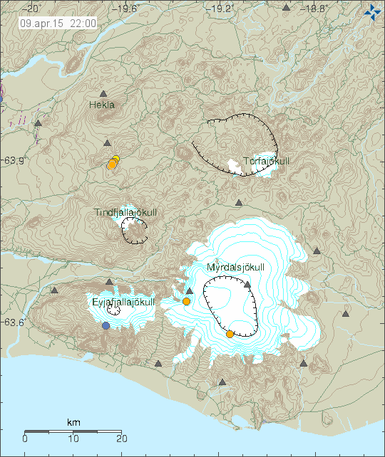
The earthquake swarm is located north of Mýrdalsjökull and Eyjafjallajökull. South of Hekla volcano. Copyright of this image belongs to Icelandic Met Office.
This earthquake swarm appears to be tectonic in nature. This means there is a higher chance it might be related to stress changes in SISZ (South Icelandic Seismic Zone), rather then any activity in Hekla volcano. There is little chance in my view that this activity is going to trigger any eruption in Hekla volcano, I just can’t rule it out at the moment. Currently it appears that this earthquake swarm is ongoing. This earthquake swarm doesn’t appear to be moving quickly at the moment, that might change but I am doubtful that is going to happen while minor earthquakes are just taking place. If stronger earthquakes start to happen this minor earthquake swarm might grow into a middle sized one or a big one. Largest known earthquakes in this area have reached magnitude Mw7,0. Such earthquake has not taken place in this part of SISZ for the past 103 years. Currently there is nothing indicating that earthquake with that type of magnitude is about to take place.
Donations: Please remember to donate to support my work. It can be done with the PayPal button or by shopping truth the Amazon banners that I have here. Donations regardless of the form they are in help me to do this work and inform people what is going on in Iceland when it comes to geology. Thanks for the support. 🙂
Article updated at 00:20 UTC on 10-April-2015.
Thanks for the update as always, Jon 🙂
It’s been mentioned a few times on FB, but as time passes I’m thinking the glitch or ice on antennae explanation for the reading of inflation near these quake sites is questionable? Other GPS readings appear normal, and the one nearest to the quake site, MJSK, appears to show nothing significant, though it has been offline a lot. I don’t know, so merely asking what people here think.
http://strokkur.raunvis.hi.is/gps/SODU_rap.png
http://strokkur.raunvis.hi.is/gps/MJSK_rap.png