Felt earthquake on South Icelandic Seismic zone

During the night of 30-December-2021 at 04:16 UTC an earthquake with magnitude of Mw3,0 was felt in Selfoss town and Hveragerði town. This earthquake was part of a swarm in the area that is ongoing at the writing of this article.

Green star on the far right on the map with few red dots, showing the earthquake activity in SISZ
Earthquake activity in SISZ. Copyright of this image belongs to Icelandic Met Office.

There are no volcanoes in this area so this is only a tectonic activity. It is not possible to know when this earthquake swarm ends. This might be a aftershock activity after the Mw6,3 earthquake in SISZ that took place in this location in the year 2008. I expect this earthquake swarm to continue to few more days to weeks and then just end quietly.

Update on the Mw5,2 earthquake south of Hekla volcano

The earthquake today (11-November-2021) at 13:21 UTC with the magnitude of Mw5,2 seems to align it self with faults that are part of SISZ rather than being part of Hekla volcano system. The high frequency tone on 2 – 4Hz that I did see on few nearby SIL stations has started to lower again after the main earthquake. Earthquake activity in the area is currently dropping but it might increase again without warning.

Continue reading “Update on the Mw5,2 earthquake south of Hekla volcano”

Earthquake north of Hveragerði town

At 01:28 UTC on 27-October-2021 an earthquake with magnitude of Mw3,3 took place 4 km north of Hveragerði town. This earthquake was clearly felt in Hveragerði and nearby area. No damage has been reported because of this earthquake according to earliest news.

Earthquake north of Hveragerði shown with a green star
Earthquake north of Hveragerði. Copyright of this image belongs to Icelandic Met Office.

There is a chance there is going to be more earthquake activity in this area. But few earthquakes with no more activity is also common in SISZ.

Earthquake swarm close to Hveragerði (South Icelandic Seismic Zone)

Today (10-Januar-2020) at 13:10 UTC a earthquake with the magnitude of Mw3,9 took place just 4,9 km outside of Hveragerði town in south Iceland. This earthquake was felt over a wide area. Several small aftershocks have taken place following the first earthquake.


The earthquake activity in SISZ just 4,9 east of Hveragerði town. Copyright of this image belongs to Icelandic Met Office.

It is unclear if this earthquake is a foreshock or just normal earthquake for this area. Its been 12 years since two Mw6,3 earthquakes (May 2008) took place in SISZ and the shortest time between earthquakes of this size on SISZ is around 10 to 13 years.

Currently my geophones are offline due to technical issues that I am going to fix in March after I have moved back to Iceland.

Donations

Please remember to support my work with donations. It helps me to keep this website going and continue to work on monitoring earthquakes and volcano activity in Iceland. Thanks for the support. 🙂

Small earthquake swarm on SISZ 6 km north-east of Selfoss town

Today (13-February-2018) at around 08:00 UTC a earthquake swarm started in SISZ just 6 km north-east of Selfoss town. This earthquake swarm is currently ongoing. Largest earthquake so far had the magnitude of 2,8 and was felt in Selfoss and nearby farm.


Earthquake swarm in SISZ today. The red dots show the location of the earthquake swarm. Copyright of this image belongs to Icelandic Met Office.

Last earthquake swarm in this area was in 21-October-2017 in this exact same location (article here). No damage has been reported following this earthquake and in Iceland no damage is to be expected from a magnitude 2,8 earthquake.

Strong earthquake swarm in south Iceland yesterday (20-October-2017) – minor damage reported

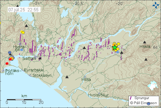
Yesterday (20-October-2017) a strong earthquake swarm happened in south Iceland on the SISZ fault zone. This earthquake swarm is currently ongoing and stronger earthquakes cannot be ruled out at this point.


The earthquake swarm as of the writing of this article. Copyright of this image belongs to Icelandic Met Office.

Largest earthquake that has happened so far had the magnitude of 4,1 and four magnitude 2,9 earthquakes have happened at the writing of this article. During the strongest earthquake yesterday some minor damage has been reported, items falling out of shelves and breaking, picture frames getting skewed on walls. For a short time the village of Stokkseyri lost all line phone communication, I don’t know how long that outage lasted but phone service was restored quickly according to the news on Rúv. Largest earthquake was felt over a wide area, all the way to Reykjavík and up to Akranes village and east to Hella village.


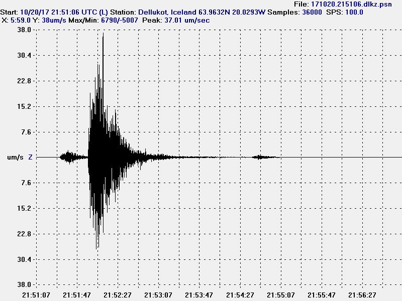
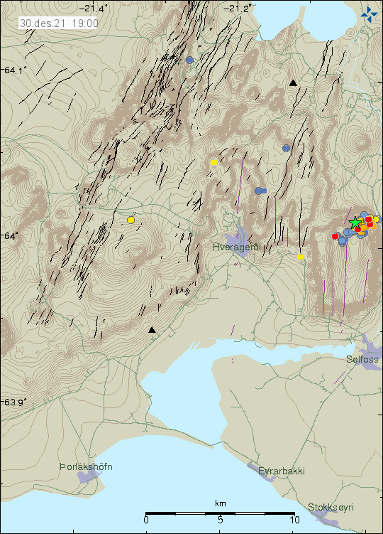
The magnitude 4,1 earthquake as it appeared on my geophone in Dellukot. This image is under Creative Commons Licence, please see CC Licence page for more details.


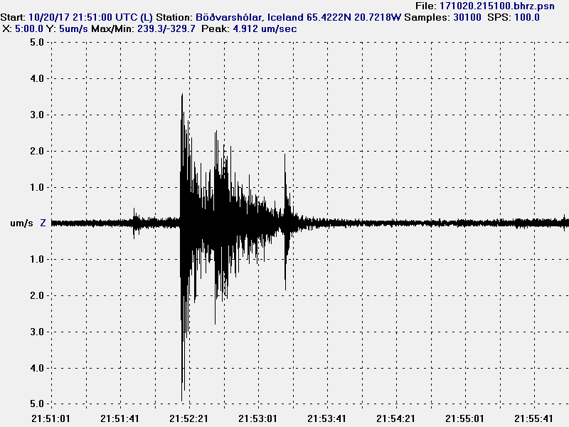
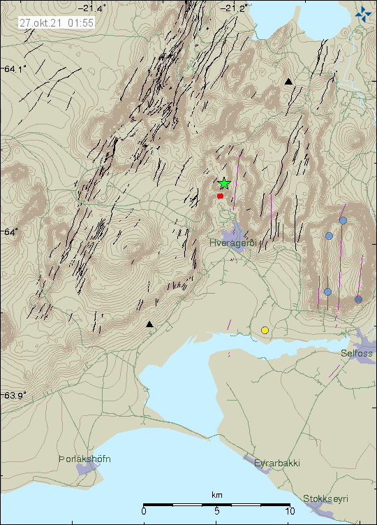
The magnitude 4,1 earthquake as it appeared on my geophone in Böðvarshólar. This image is under Creative Commons Licence, please see CC Licence page for more details.

I don’t know if this earthquake activity signals a new period of earthquake swarm in SISZ. I have listed large history of earthquakes of the SISZ in a article from 2011 here.

Donations

Donations help me running this website properly and keep everything going properly. Donations also help me to buy food and pay the bills so I can write more articles about earthquakes in Iceland and future eruptions that are going to happen in Iceland. Thanks for the support. 🙂

Earthquake swarm in SISZ (South Icelandic Seismic Zone)

Today on 6-May-2017 a magnitude 4,4 – 4,5 earthquake hit South Icelandic Seismic Zone (SISZ) at 12:08:58 UTC. This earthquake was felt over a wide area, a magnitude 3,3 earthquake also took place around one minute after the main earthquake. The earthquake took place on a fault that might have last moved in the year 1623 or 1624, as is detailed here. Current earthquake activity does classify as a “Suðurlandsskjálfti”, only earthquakes with magnitude above 5,5 are classified as such. This is regardless a strong earthquake activity in SISZ for a long time now.


The earthquake activity on SISZ. The green stars mark the location of the magnitude 4,4 – 4,5 and the magnitude 3,3 earthquakes. Copyright of this image belongs to Icelandic Met Office.


The magnitude 4,4 – 4,5 earthquake as it appeared on my geophone in Böðvarshólar, north-west Iceland. This image is under Creative Commons Licence, please see CC licence page for more details.


The magnitude 4,4 – 4,5 earthquake as it appeared on my geophone in Heklubyggð, the earthquake happens just west of this geophone location. The geophone is saturated by incoming earthquake signal. This image is under Creative Commons Licence, please see CC licence page for more details.


The magnitude 3,3 earthquake as it appeared on my geophone in Heklubyggð, the earthquake happens just west of this geophone location. This earthquake also saturates the geophone (just a little). This image is under Creative Commons Licence, please see CC licence page for more details.

More aftershocks are expected in this are for the next few hours to days. It is difficult to know if this means there is going to be a larger earthquake activity at this location or nearby. It’s always a chance, but it is not possible to know that for sure.

Donations

Please remember to support my work with donations. May is rather difficult month for me financially. Thanks for the support. 🙂

Article has been updated at 15:55 UTC. Minor text fixes.