
There is been a highly localized earthquake swarm in Kistufell area in the highland. This area is well known in Iceland for high earthquake activity and often makes earthquakes that are close to Mb5.0 in size. The current earthquake swarm is rather small in comparison to many earthquake swarms that have taken place in this area before.
This does not mean that there is going to be a eruption there. As this area is highly activate in regards to tectonics forces in this area. But this area can erupt and has done so in the past. But this area belongs to the Bárðarbunga volcano and it has fissure types of eruptions when it erupts.
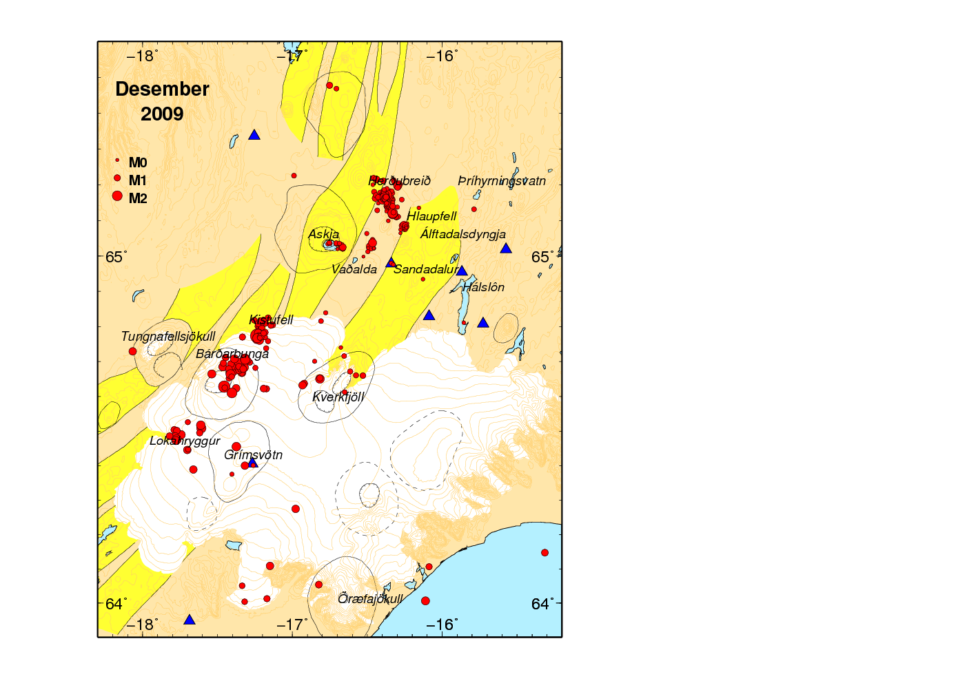
Here is a picture with the activity of this area in December 2009. As can be seen there, this area has a lot of earthquake activity almost all of the time. The text with the picture can be found here in Icelandic. Use Google Translate with the normal risks involved.
😮 With 90%
Thursday
03.02.2011 23:54:43 64.747 -17.250 3.2 km 2.8 90.04 4.2 km SSW of Kistufell
Thursday
03.02.2011 23:49:40 64.754 -17.252 2.5 km 3.0 90.04 3.6 km SW of Kistufell
The magnitude is slightly less than stated above
3.7 km SV af Kistufelli, Feb 03 2011 23:54:44 GMT 64.76 -17.27 Mag 2.5R
2.3 km S af Kistufelli, Feb 03 2011 23:49:41 GMT 64.76 -17.22 Mag 2.4R
Early news of the quakes last morning
http://mbl.is/frettir/innlent/2011/02/03/jardskjalftar_vid_kistufell/
Wow, Kistufell is certainly a bit lively at the moment. Perhaps an eruption might follow soon!
we don´t think so.
the area is known for quite intense tectonic quakes – so far the swarm seems to be minor.
at the moment the seismicity beneath myrdalsjökull looks more interesting.
What is going on at Snaebyli?
http://hraun.vedur.is/ja/oroi/snb.gif
Thats not wind for sure.
Never mind…It was a few days ago. Just noticed.
No worries. Depending on which of two activities you where refering to it is either a storm that passed over, or some activity that happened after a large quake (well, relatively) in the south east of Katla caldera.
This was the part i was referring to.
http://i52.tinypic.com/2ymdmok.jpg
I have a hard time believing that it was caused by wind. It seems more like the EQ caused this.
That was the quake that caused that. It was rather large, I think it was about 2,5, nice depth and in the southeast rim of the caldera.
It made Snaebyli and Lagu-Hvolar “bubble and burp” a bit.
My interpretation was that Katla tok a zip of beer, vomited in her mouth, swallowed it down and went back to bed. Ie, another aborted eruption.
These abortions seems to be going around a lot right now.
But, sooner or later the “vomeratoria ultima icelandica” will open for business again.
Just wondering. The must be some magma chambers which have never erupted ever yet. Do we know where they are? I guess Godabunga is one of them? How about others?
Hm, good question. I think Askja has a crypto-dome to, but I am not sure.
I think there is a lot of unknowns concerning the locations of crypto-domes in Iceland.
But there should be some around. One of them is probably under Burfell/Isakot at Hekla. But the place I would guess there are quite a few of them would be at the new volcanic zone (new only in the sense of geological ages) in the eastern part of Iceland. Ie, where you have Esjufjöll and those more unknown dudes. I would guess there are crypto-domes all the way from Esjufjöll upwards.
But, I am guessing about the eastern zone, and there is only secondary evidence for Askja, and Hekla could also be a dyke with sill intrusions towards Hekla proper.
It would indeed be interesting to know but probably very hard to confirm the prescence of any magma chambers. It is difficult enough to determine the mechanics and size of the well known ones. 🙂
But an eruption from a so far unknown chamber in a remote place would be very nice to see. A volcano buildup before our eyes..
Well, I think that Godabunga is our best bet for that.
Would be cool to see a third volcano come to life between Gudnasteinn and Katla.
(Sorry Renato, Eyja is a shemale. The male volcano of Gudnasteinn (Godstone) lives in the female body of the Eyjafjallajökull (Island mountain glacier) 🙂
And sofar I haven’t really seen hard proof of Godabunga belonging to either Gudnasteinn or Katla. It might after all even be a separate one. And yes, I know what others say about it, but I have my view here;)
It woud be really awesome to see a new volcano erupt!
There was a very interesting research article I read recently re: the suspected cryptodome under Godabunga but the link I had is now broken. Isn’t there a strong consensus that due to the level of activity there this would be the next likely eruption site?
Here’s that article
http://www.sciencedirect.com/science?_ob=ArticleURL&_udi=B6VCS-4J3WS9F-2&_user=10&_coverDate=05%2F15%2F2006&_rdoc=1&_fmt=high&_orig=search&_origin=search&_sort=d&_docanchor=&view=c&_acct=C000050221&_version=1&_urlVersion=0&_userid=10&md5=6bfb37541dd76d82eae78a69c498393b&searchtype=a
@RonF:
No not really.
There is 4 camps (at least!).
1. Gudnasteinn erupts again.
2. Gudnasteinn Erupts again, and Katla follows at number 4.
3. Godabunga erupts, being either a volcano on its own, a part of Gudnastein, or being a part of Katla. Or showing itself to be the “hidden graal” of connection between Gudnasteinn and Katla.
4. Katla erupts at Austmannsbunga, that seems to have the most votes among the icelandic volcanologists.
and then there is five…
My own theory, that Katla will erupt at the south-eastern rim. That is after all the place that had the weird burpy tremorsignature after the mid-sized quake earlier this week.
Askja volcano had a crypto dome. It blew up in a eruption in the 19th century that created the caldera that we see today.
Here’s that article on the suspected cryptodome forming under Godabunga
http://www.sciencedirect.com/science?_ob=ArticleURL&_udi=B6VCS-4J3WS9F-2&_user=10&_coverDate=05%2F15%2F2006&_rdoc=1&_fmt=high&_orig=search&_origin=search&_sort=d&_docanchor=&view=c&_acct=C000050221&_version=1&_urlVersion=0&_userid=10&md5=6bfb37541dd76d82eae78a69c498393b&searchtype=a
is there a possibility to get some kind of access to that document? i don’t have an university student id or something like that.
it would nice to have a discussion about cryptodomes, because for me this is still a very unknown topic. i mean, i dont really got what exactely a cryptodome is.
as far as i understand it, its some kind of a very viscose body of magma – thinking of obsidian or another type of magma like that – which hasn’t broken trough the surface, yet. as an example for this kind of magma i would point to the obsidian lava flow in landmannalaugar, with the difference that this one has made its way to the surface.
so my question is, have i got i right or is there a flaw in my theory about a cryptodome?
As far as I have understood a crypto dome, it is formed by warmer then normal magma that melts the bedrock ontop. If the body of magma is large or hot enough it will sooner or later eat it’s way up to the surface and then becomes a normal volcano.
http://qvsdata.wordpress.com/learning-links/icelandic-research-links/
4th item under Myrdalsjokull
I think this is the PPS version of that.
Interesting PPT, thanks.
Cryptodomes. I remember that from last year’s discussions.
Cool stuff! 🙂
cryptodomes… had to google it up…. veeerrrrrry interesting….
but somewhat self limiting….(if You know about it, it’s no longer crypto)..;)
Best!motsfo
Mots Fo:
Much of what volcanology concerns is cryptic to my layman eyes.
We do live in a cryptoplanet, in a cryptouniverse.
🙂
Yeah, i used to have all the answers….
.
.
.
little did i know that i didn’t even know the
questions yet…… 🙂
Best!motsfo
I infer from the contributions to this blog that actually understanding what the physical structure is like beneath the surface,(i.e. detection of Cryptodomes or if dykes or magma chambers are filling or subsiding) is still a black art is largely inferred.
A discussion on the current state of play wrt to subterranean imaging/mapping would be helpful. What are the current limitations/problems to be overcome, what progress has been made in the last 40 years, what new technologies are emerging that will benefit volcanologists in the future. I would have though the mining industry has made significant advances in this area and some of these advances could assist in getting a better picture of what structures lie beneath the surface. Carl, you may have some ideas on this last point.
Actually you can do it.
It is sadly more a question of money, then a question of technology.
To my knowledge there is only one volcano that has had it’s innards mapped out. The current cost of making a 3D map of a volcanos magma reservoir landed at 3 years and 8M€.
What we used was 10 pieces of 0-150 hertz arrayed sonographs combined with 3D-accelerometers drilled down into the mountain and then packed in liquid nitrogen. Then we used explosive charges around the mountain. Then we just summed up the wave-fronts as they interacted with each other and the various materials and how they reflected. Ontop of that initial map we have used the mountains natural quakes do get an ever higher degree of precision.
Let me just say that after seeing that map, I will never again say magma-chamber. Magma-reservoir is slightly better, but I would use the world tubinged-layered magma infiltration instead. It looks like the innards of an anthill down there.
A good analague would be the plumbing system of Empire State Building, but 36 kilometres high, and with magma instead of water and crap in it.
I would say we have the technology, some was developed by the large oil-companies, and some from the mining industry. We just scaled it up.
The thing is to get the cost down. We blew off more than the combined US/EU seismology/volcanology budget on doing that map, so prices have to go down with a factor of at least 100. As a big energy company it is peanuts, but for science it is humongous amounts of cash.
Even if we could get rid of the liquid Nitrogen it would still be too expensive.
My guess is that it will take at least 10 more years before it is feasible to make maps of volcanos innards. And then I would guess it would be done as a mobile unit that is carted around as needed in Europe. Equipment like that will probably never be economical for all of the volcanos in Europe, and Europe is currently the only part of the world with the economy to pull it off to beginn with.
Which volcano was that?
I watched a doku where they mapped the magma chamber of the Soufriere Hills at Monserat.
Mt Fako.
Crap, forgot that noone knows that name. It is also known as Mount Cameroon.
It is the most active of the west-african volcanos, and the only volcano with heards of wild elephants and a runners competition.
Thanks for detailed reply. Explains why eruption prediction is such a black art, no one can actually see whats going on. hopefully the cost will come down and our understanding will take a great leap forward.
p.s any pics of Mt Fako,
I did google up something called Audiomagnetotelluric profiling, which has been done at Stromboli and the Azores, but it the website did not allow me to get more detail.
Sorry, skipped the occasional word and left a typo or two.
Simplified, I am asking \Where is our equivalent of an MRI Scan for a Volcano, not a mathematical model turned into graphic, but an actual picture.\ If we don’t have this now, will we ever?
Ah, an MRI scanner is impossible, what we are doing is the same as when a submarine builds up an image.
Think sidescan-sonar hear. We first used the rig as a soner to get a base-map, and then we went into passive and used it as a hydrophone to get the finer details.
Short anser, we have it, but it is to expensive to use if you are not counting on making a profit on it.
Carl,
do you mean bouncing sound waves through the crust, where the earth is the medium for carrying the signal, like water is the medium in a submarine sonar? Does this method capture the detail within the medium, like seeing fish in the water with sonar or does simply reflect back when there is a change in the medium, i.e like the ocean floor? Are there examples you could direct me to where this has been applied to a Volcano?
i think i may have found some interesting papers about the seismicity near Myrdalsjökull:
Habits of a glacier-covered volcano: Seismicity patterns and
velocity structure of Katla volcano, Iceland
http://www.igsoc.org/annals/45/a45a068.pdf
The Skerin ridge on Eyjafjallajökull, south
Iceland: Morphology and magma-ice
interaction in an ice-confined silicic fissure
eruption (very interesing and informing)
http://www.raunvis.hi.is/~mtg/nemritg/BV-MS_2009.pdf
Volcano geodesy and magma dynamics in Iceland (very interesing and informing)
http://notendur.hi.is/~heidi/Data/Article-richard/Sturkelletal06a.pdf
the last one is especially interesting because it covers almost every volcano in iceland including hekla and the borehole strain levels from the 2000 eruption. you almost have to take a look at it, if you dont know the document already;)
damn, you can find quite a hell of stuff if you end up at the right place to search (not google)
Physical process of cryptodome formation by precise DEM analysis- Mt. Usu (1977-82)
and Mt. St. Helens (March-May, 1980)
http://wwwsoc.nii.ac.jp/jepsjmo/cd-rom/2007cd-rom/program/pdf/V156/V156-007_e.pdf
Internal structures of a subaerial dacite cryptodome
at Usu volcano, Hokkaido, Japan
http://www.lib.muroran-it.ac.jp/kiyo/54go/54_irai01.pdf
Google Scholar?
i searched on some of the staff websites of universitys from there i went a little further but it took me almost two hours to find some of the more interesting stuff. i also found a book somewhere on the USGS Website about Mt. Helens. Somewhat about 20 Chapters or more you could go through, wuth lots of mathematical formulas and much more, but i wanted to have the center of interest on iceland, so it was a bit difficult to get what i was looking for.
http://notendur.hi.is
http://www.raunvis.hi.is
are two icelandic pages where you could look for further infos, i wasnt able to search all of it yet.
http://www2.norvol.hi.is/
that would be the Nordic Volcanological Center, i’ve forgot to put that up to, somehow the link notendur.hi.is doesnt work, and i don’t know why.
I am now in Denmark. Things should start going to normal update rate soon. I am not sure when exactly that might happen. But it is something less then two weeks away I think.
@Jón:
Good luck!
Hope you settle in well in your new home in Denmark!
The Goðabungu activity is looking more and more interesting, I must say. Any thoughts on this? Where we earlier could observe quakes related to the ice cap, we’re now to a certain extent seeing more of the deeper quakes.
Ehm… there have been unusually few quakes related to Godabunga lately.
So I have a bit of trouble following your reasoning on that one. Lately the center of activity have been at Katla.
you can look one the summary page of quakes here to get a more realistic oversight over the quake activity near Godabunga and Barbadunga.
http://hraun.vedur.is/ja/viku/2010/dec/index.html#mark
[Fyrri mán.] this one means last month
[Næsti mán.] this one means next month
[Aðrir mánuðir og vikur] with this link you go back to the whole database, from there you can select a specific year and then either get the map for a specific week or month of a year.
for example: click on 2004 (http://hraun.vedur.is/ja/viku/2004/)
then on vika 01, you then get the map for week 1 of 2004… its very interesting and you really can get a realistic view of the quake activity in iceland over a week, a month, a year or even over a whole decade ; ) it depends on how much clicks and time you want to spend ; )
so you can click through years of quakes
All the way into late summer, EQ activity around Katla was almost all related to icecap subsidance with very rare quakes deeper than 4 or 5km. If my memory is correct, its been the last several months that we’ve seen a large increase in the # of deeper quakes near Katla.
Lurking, have you done any plots recently for Katla that would span 1 year?
Well.. yeah. But I tend to make them up on the fly as needed.
So… from 2010 to present, setting the western boundary at Fimmvorduhals so that that activity is out of the way,
View North:
http://i55.tinypic.com/2yxi4w7.png
View East:
http://i52.tinypic.com/hug3ls.png
And, a time vs depth vs magnitude (ML):
http://i55.tinypic.com/2yxi4w7.png
All of these plots use the same data boundaries (as annotated on the time plot)
#$#$#$ … the time plot, correct link:
http://i52.tinypic.com/dpwi92.png
Montserrat now has a race.
http://www.volcanorunner.com/
I’m sure that SOufriere hills volcano was mapped internally too.
That was a reply to Carl.
We have sailed past that volcano..day and night passages. I don’t think a race on Montserrat is very smart!
The race doesn’t enter the exclusion zone as far as I know. The closest it gets is the entrance to Air Studios.
Hey Jon!
Good that you have arrived in Denmark. I hope you can get settled soon and feel at home in your new country.
Is the sun out?
it was -20 C this morning and i’m looking at 2foot of snow.
(like up to Your knees in metric) 😉
Best!motsfo
3.4 mag earthquake at Hamarinn: Sunday 06.02.2011 01:07:07 64.501 -17.609 1.1 km 3.4 90.1 9.7 km E of Hamarinn
Let’s see if there are any more coming….
Yes there are more!, some of the are poorly located though so guess depth and strength will change, so far 3 above mag3 in kistufell region and quite some smaller quakes
Sander
Quite activ at the moment….
some a poor quality, but several with 99,90, i.e. reviewedand okay.
Interesting…
I haven’t been around much lately. I hope your move to Denmark went smoothly, Jon, and that the move brings all you wish in a good way.
Not volcano photos but Icelandic water ones – beautiful nonetheless.
http://www.mymodernmet.com/profiles/blogs/dramatic-waters-of-iceland-12
A new blog post is up! 🙂
I signed up for USGS ENS (Emergency Notification System) which sends emails when quakes occur. I didn’t get notified for the 3.3 Sunday, 07:51:25. If I remember, someone posted that USGS only registers quakes >= 4.0. Is this correct?
I would like to get a more timely notification of any quakes larger than 3.0 in Iceland. Is there a public notification service in Iceland similiar to the USGS ENS system that one can subscribe to? Thanks in advance!
I use the ENS for my community of worldwide cruising stations–since the Chile earthquake. As far as i can tell, USGS does not update some quakes but they show on the GFZ Potsdam EQ notification. But I also think you can set your ‘threshold” and get some of the smaller quakes..but only in some areas (USA). I would be interested in another source as well, as some of the smaller islands in the Pacific or Caribbean really need valid tremor information — Nuie for example– in the case of tsumanis.