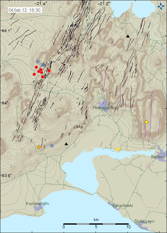
There was an earthquake swarm starting in Hengill volcano. This earthquake swarm is at the usual location, close to the hydro-thermal power plant. But this earthquakes happen as the hydro-thermal power plant pumps down cold water into the ground.
This earthquake swarm started at 18:08 UTC on 04.02.2012. The largest earthquake so far in this earthquake swarm is an ML2.5 in magnitude according to automatic results from Iceland Met Office.

The earthquake swarm in Hengill volcano. Copyright of this picture belongs to IMO.
It is hard to know for sure if this is just the start of the earthquake swarm or not. But earthquake swarm have been common in this area over the past few months due to water being pumped down into the ground.

Wide spreaded EQs in Katla area right now. Looks strange.
yes, it looks like an earthquake swarm.. but it looks unusual..
perhaps an error?
I too think this is unusual. hengil swarm and these widespread quakes round Katla. Very odd
Agreed, it doesn’t look like the usual patterns we see there. Too spread out and not in the usual locations. Surely the fracking near Hengill can’t have caused earthquakes this far out though? Also they seem to be quite shallow depths. Definitely something to be keeping an eye on over the next few hours.
Follow on from the EQs on the Reykjanes Ridge may be?
http://en.vedur.is/earthquakes-and-volcanism/earthquakes/atlantic/
Strange all this earthquakes in the South of Iceland !
I think this is just a LOT of noise from bad weather and a swarm at Hengill. I am not sure if something happened in Katla. Actually, tremor graphs show only a couple of earthquakes and nothing else. Maybe there was also a small swarm in Katla.
About an hour ago I felt what it seemed a small earthquake (I am in Grimsnes). I did not give it importance as I was busy doing a work. Maybe it was the 2.5-3.0 at Hengill.
PS: there is also a gale starting now. So, bad weather makes a mess.
An hour ago, at 19:24 there was a quake said to be R5, you can see it at the N-Atlantic map, the one you talked about was at 18:14
Look at the Geysers in California. Water injected for power and over 100 earthquakes a week.
Today (Sunday) and we now see wide spread EQs but this time in the north….all rather random! Any thoughts anyone?
They cover three “volcanic centers” – Hengill (inkl Krísuvík et.al), Katla (incl Tindfjallajökull, Torfajökull, Eyjafjallajökull) and Askja (incl Herdubreid et.al). Most of them are shallow to very shallow, i.e. above the arbitrary 4½ km delineation between magmatic (below) and hydrothermal (above) employed by IMO. The one exception being Hengill where we know the reason – ongoing human activity at Hellisheiði Geothermal Power Plant.
Of course someone somewhere will claim that these quakes are proof of at least three “supervolcanic” eruptions on Iceland on or around December 23rd…
Even if I do not believe in “super” eruptions, it would be interesting to know why these earthquakes happen in this way – even if there are errors in the measurement.
Has anybody been over the top of Katla to see what the caldera is like since the summer ?
You cannot see the caldera since it is covered by 700 meter thick ice cap. You just see a flat ice plateau over the top of Katla, and curving down on all sides, from where outlet glaciers “fall” down.
It looks like this at the top
http://iceland.nordicvisitor.com/resources/Images/Iceland/travel-guide/south-iceland/myrdalsjokull/Super-Jeep-at-Myrdalsjokull.jpg
And like this from the eastern side of Katla, some 20km away
http://cdn.c.photoshelter.com/img-get/I0000HHzhJqvcKbI/s/750/750/Hofdabrekka-MWL0025407.jpg
And like this from the top aerial view (viewed from the north)
http://robertwcorkery.files.wordpress.com/2010/04/katla-img_33961.jpg
manythanks some beautiful photos
There seems to be something about frost-quakes now in Iceland, due to cooling weather. This is creating a lot of earthquakes on IMO automatic maps.
I found this about frostquakes in USA:
https://en.wikipedia.org/wiki/Cryoseism
Fresh earthquake swarm in Katla this evening… 1822Z judging by Jon’s helicorder…
New blog post is up! It is about Greenland for an change.