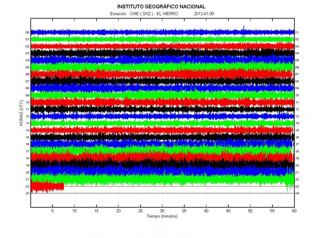
The eruption in El Hierro volcano continues with on and off rhythmic at the moment. So fluxuations in the harmonic tremor plots can be rather huge. That is from considerable amount of tremors down to no harmonic tremors at all.

The harmonic tremor in El Hierro volcano. Copyright of this picture belongs to IGN (Instituto Geográfico Nacional).
Here is also an video of the eruption in El Hierro volcano. I do believe that this pictures are rather new. But I am not sure. The audio is Spanish.
It is impossible to know for how long El Hierro volcano is going to keep up the current eruption pattern. But this pattern might stop at any time, without any warning at all.

Fracking has recently gained increased public interest in the USA, here’s one review on it: http://desmogblog.com/year-dirty-energy-fracking
And some background: http://en.wikipedia.org/wiki/Fracking
Off-topic: total storm weather in Iceland. Blizzard and winds up to 150km/h for the third day in a row. Power was disrupted in some places and most sections of the ring road are today closed. Its quite crazy outside. So, most earthquakes cannot be detected today.
Trausti Jonsson is saying that a storm from Greenland called Piterak may reach Iceland.
http://visir.is/graenlenskt-ofsavedur-gaeti-nad-til-islands/article/2012120119995
http://www.vedur.is/um-vi/starfsfolk/persona/80/fyrirtaeki/1
Good news. I do not have to buy new monitor since I have some old monitors in storage that I can use (they are not good, but can be used for this). But I have to buy new keyboard, mouse, wireless network hardware and DVI to normal screen adapter. It is cheaper, but the cost is going to be around 500 DKK with current estimates that I have made.
M 7.3, off the west coast of northern Sumatra
Date: Tuesday, January 10, 2012 18:37:01 UTC
Wednesday, January 11, 2012 12:37:01 AM at epicenter
Depth: 29.10 km (18.08 mi)
Was watching some interesting stuff on CO2/SO2 emissions and how they can be used to predict or gauge an eruption. Seems that SO2 emissions are typically indicative of smaller eruptive episodes while larger quantities of CO2 denote a larger eruption. So I’m watching CO2 emissions. Currently they are on the rise, which I suspect may indicate decompression of CO2 deep within the magma chamber, could mean El Hierro is gearing up for more action!
Where did you get the CO2 figures?
Seems they are hard to get.
i notice all the canary island graphs picked up the large earthquake off Sumatra Except for the Tenerife one? how come?
It might be an short period seismometer.
Here you can find information about sil stations in spain, catecorized by type of connection:
http://www.ign.es/ign/layoutIn/volcaListadoEstaciones.do
For example initial settings of CHIE:
http://www.ign.es/ign/none/sismoRespuestaEstaciones.do?respuesta=RESP.ES.CHIE..SHZ&ver=si
Hope someone ha suse of this…
Many of the SIL stations have solar panels to provide power. How do they manage when there is heavy snowfall as there is today? Do people have to go out to clear them?
🙂 Yes, they have some Asian lady’s to clean, No joke! 🙂
They have solar + wind generators + 2-4 weeks batteries.
So that is usually enough . The sun is not doing much at this time of year so the wind generators have to stay fit. Sometimes they brake in heavy storms with icing. But the solar panels are vertical, so no cleaning.
The radio links sometimes brake down by icing or lightnings.
Ups.
Break down
Thank you for that Wagabond 🙂
When they have a vacancy for SIL cleaning duties let me know 🙂 My cleaning skills are excellent 😀 . I could ride Icelandic horses if the roads are bad, and I need to visit Iceland 😀
Nice video – thanks Jon. Activity seems to be steady all day at El Hierro – this seems different from the past where it has been mixed with explosive activity. Just outpouring of material – perhaps through a widened vent ?
I think iceland and england have swapped weather! We normally get storms, snow, rain etc..!
Not really. Storms (and heavy storms) are not unusual in the winter in Iceland. Although this one was pretty hard.
I didnt realist el hierro and katla were connected!? They are both on the mid atlantic ridge; does this mean anything at all or are most of the population (!) scare mongering again? Surely if there are deep shakes along this ridge it affects the whole picture; Just like the fragility of the earths ecosystem?
he never said they were connected!
The Canaries are not on the Mid Atlantic Ridge (MAR)
Even if it was , such connection seems to be very abstract to say the least.
Like with the ashes of Grimsvotn and Eyjafjalla provided by our host here, i did SEM images of samples from el Hierro.
My fotostream
http://www.flickr.com/photos/birgitha/
sample 1 was emitted before nov 26 http://www.flickr.com/photos/birgitha/sets/72157628826638247/
and sample 2 emitted on nov 27 http://www.flickr.com/photos/birgitha/sets/72157628825547273/
Hallo Birgit,
danke für die Links.
Ich habe gesehen, dass Du in Linz einen Vortrag gehalten hast:
“Unbezähmbare Naturgewalt: Vulkane_Die Eruptionen von Eyjafjallajökull und Merapi und ihre Auswirkungen aus der Internetperspektive”.
Kann man den irgendwo lesen?
Ja hab ich auf der Kunstuni und ich durfte auch bei einem Deep Space live darüber mitwirken. Nachlesen kann man den nicht, den Text gabs nur in meinem Kopf. Ich habe aber ein Video dazu geschnitten, das gebe ich gerne her und falls jeamand in der Gegend ist… ich treffe mich gerne und erzähls privat oder mache eine Führung durchs Museum für Jeden dens interessiert.
Hört sich spannend an? Wie könnte man Kontakt aufnehmen? Über das AEC?
Oder email birgit punkt hartinger @ aec.at