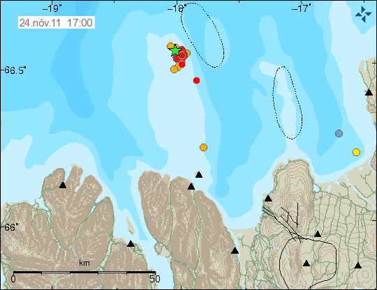
Today there has been a earthquake swarm in Grímsey Island. But this tiny Island is off the north coast of Iceland. Around 100 people live on the Grímsey Island. This earthquake swarm is small. But its location makes sure that it is felt. But it is directly under the village on the Grímsey Island. So far the strongest earthquake recorded is a ML3.3 in size with the depth of 9.1 km.

The earthquake swarm in Grímsey Island. The Island is located where the earthquake swarm is on this map. Copyright of this picture belongs to Iceland Met Office.
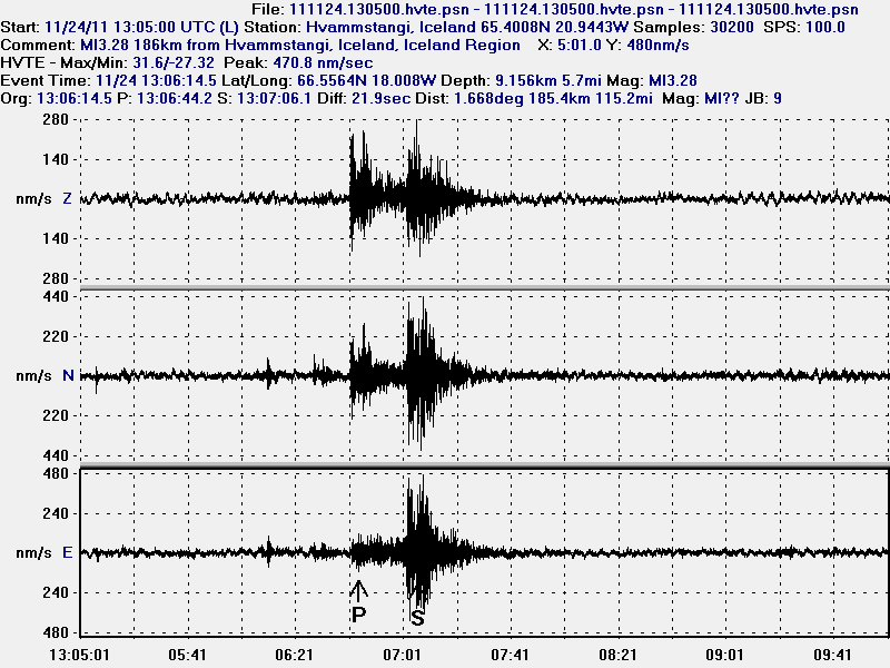
The largest earthquake so far was recorded on my Hvammstangi geophone clearly.

The earthquake as recorded on my Hvammstangi geophone. This trace is filtered at 4Hz. This picture is released under Creative Commons licence. See top bar for more information.
The earthquake swarm appears to be ongoing. I am sure that this earthquake swarm is felt in the village because it is directly under it. But depth of the earthquakes might however play a role in it how well the earthquakes are felt in the village. So far there have not been any news reports on this earthquake swarm in Icelandic Media.
Blog post updated at 00:25 UTC on 25 November, 2011

Could this be related to the hvammstangi earthquake earlier today? Sorry gatecrashing posts but been following the blogs for a while! Main interest- Katla
The Hvammstangi earthquake was yesterday and the answer is no to the question. This are unrelated events.
Took a look at yesterdays “log” at UTI. nothing to be seen except a tiny quake at 19:20 (21 min. later than your meter shows) seen here
http://hraun.vedur.is/ja/alert/2011/nov/23/055.html
and registrered at Gilhagi as well as Hveravellir and Vestmannaeyjar (you see that if you look at detail).
Swarms of EQs like that can’t be very nice. If these are tectonic, are they related to the other EQs that we have seen on MAR?
Checked out Grimesey; it is made of basalt and sandstone. So, if the island is not volcanic, there must be / have been a volcano near it once. It looks an interesting place to visit.
The island is actually on the Arctic circle the only inhabited piece of Iceland that is, I agree it looks like an interesting place. I bet the people feel a little vulnerable in an earthquake though. The area around the island has quite a lot of quake swarms that I have noticed since I started watching a year or so ago.
I see some quakes near Katla as well, Iceland is getting back to normal from all this quiet 🙂
Why is no Grímsey a volcano? It is in the continuity of the mid Atlantic rift, and the north volcanic zone. I do know that in that area, we have a different kind of tectonic rift, with mostly only earthquakes, like in South Iceland, near Selfoss. But even in South Iceland, there is also off-rift volcanoes, like Grimsnes, Hestfjall or Burfell (near Selfoss).
The storm is now over in Faeroe Islands. Top wind speed was recorded to be 54 m/s according to the news.
It’s a bit strange tremor of ESK in Katla, and takes a few hours with alterations in all frequencies and is isolated only for this season, I see a problem weather, could be the course of the water?
By the way, here’s an article that appeared in Norwegian media today:
http://www.aftenposten.no/nyheter/uriks/Katla-rumler-eksperter-frykter-utbrudd-6706515.html
That storm is a low pressure of 945mb, that is very deep for a low pressure system.
The winds no doubt effected the EQ and tremor equipment in Iceland.
It is quite common for depressions near Iceland in winter to get down to 960mb. Sometimes they even go lower, like now, so this is not at all that rare. Last year, I recorded 948mb during a storm in February. But further south, at the British or Portuguese coasts, storms very rarely get even to 960mb, usually they get only to 980mb.
Iceland is a very windy place at times, I don’t know how you cope with it, all the trees in the UK would blow down in a 945mb stor :lol:.
945mb storm that should have said…
Iceland has very little trees, but it is mostly because humans cut them, and to grow them back it takes many years.
The native forests are dense birch trees, the only native tree to Iceland, and they only grow up to 2m high. So it feels a forest with very short trees. They are well adapted to the winds. In some sheltered places, the forest can be much higher, up to 8m.
There are planted forests in Iceland with pines that grow much taller, and those are beautiful, and they also stand the winds.
In flat areas or mountains the wind often top 100km/h and sometimes up to 200km/h. If you happen to be in an open area, you cannot walk in these blowing storms. You must wait so the storm passes. These gusts are also dangerous in driving.
El Hierro… GPS interpretation (23 Nov) via AVCAN:
http://www.avcan.org/varios/20111123desplazamientosGPS.pdf
I saw this too, can you explain the results in lay mans terms.. I think I have a fair idea, but as a layman what are the impending risks of this movement?
Not too sure as it is not clear whether the readings are daily or cummulative.
But the maps indicate the direction of displacement. Frontera, Valverde and Restinga contine to move north eastward and Sabinosa to the northwest. Frontera is also showing elevation (the plots for the others are not so clear).
The start date for the maps is not 1 Nov – so the maps do not show November’s motion. The datum date is not stated so the maps are useless.
(We can see that is we compare Frontera map (30mm north) with the graph – which is flat.)
The graphs are more useful – they have dates. But the date scales are all different so we cannot easily compare time courses. The whole lot need replotting on a common time course.
New blog post about bogus news story about Katla volcano is up!
This data obove does not really fit together with those: http://i42.tinypic.com/1zlxbew.png
Think the difference is due to difference time periods; Lurking can confirm if I am right or not.
Update 25/11 – 13:32
– PEVOLCA has decided that all evacuated people are allowed to return to their houses. As the La Restinga people were already allowed to sleep at home, this decision was taken to allow the return of the families of the Las Puntas area who had to be evacuated after the M 4.6 earthquake from a couple of weeks ago.
Pevolca maintains however the Red Alert for La Restinga (municipality of El Pinar) and the yellow alert for the rest of the island.
The only Civil Protection extraordinary measures that are currently maintained is the closure of the beaches of Puerto Naos and Tacorón as well as the maritime NO-GO area (radius 4 km).