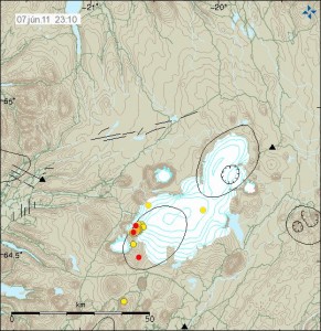
Today has been spotted with earthquake swarms in Iceland. This earthquake swarms have not been big so far in both terms of earthquakes and size of the earthquakes. With the biggest earthquakes in South Langjökull volcano (Presthnjúkar). The biggest earthquakes in South Langjökull volcano have been around ML2.5 in size. With the average depth of 10 to 5 km. Total number of earthquakes is something around 39 and that is an small earthquake swarm.
The area in question is known for earthquake activity. Few years ago there was an earthquake swarm in this area with several ML4.0+ earthquakes. This area did also see earthquake swarm earlier this year. So far nothing suggests that an eruption is close in this area.

Map from Icelandic Met Office showing the area with the earthquake swarm. Click on the picture to get full size. Copyright of this picture belongs to Icelandic Met Office.
Krýsuvík volcano did also have an minor earthquake swarm today. The largest earthquake in Krýsuvík volcano was ML2.1 with the depth of 3.9 km. So far this earthquake swarm has been an minor one. With just over 32 earthquakes happening today.
Other earthquake activity in Iceland is currently not an lot. A ML3.1 earthquake took place few days ago in TFZ in an area that commonly has earthquake swarms. That area does not have any volcanoes, so earthquakes there are only connected to faults in the fault lines in that area.
Blog post updated at 23:29 UTC on 7. June 2011.
Blog post updated at 23:35 UTC on 7. June 2011.

Presthnjúkar, that’s the shield volcano you can see from Thingvellir national park right? I was told that volcano was dead.
Presthnjúkar is an lava dome. But the volcano that did create this lava dome is just dormant.
But so far nothing indicates that this volcano is about to erupt.
I think it’s still considered active due to hot springs at the base of the mountain. But if you check the link from Jón’s blog you will see that the 13 cubic km eruption in 3350 BC(wikipedia says 7550 BC http://en.wikipedia.org/wiki/List_of_volcanoes_in_Iceland) is not a possibility today with the current knowledge of only a small magma chamber under the volcano.
Wikipedia goes on to quote the existance of a fissure system going on an axis NE and SW from the volcano under the small glacier to the south and the much larger Langjökull to the north.
So it seems to be listed as active, but not with any solid data on eruptions in settled times(I guess there is a posssibility of smaller subglacial eruptions that’s hidden by the ice in the rifts).
Does anyone know if the springs (geothermal or otherwise) in Iceland have any radioactivity to them? Alot of the springs here in Somerset are mildly radioactive, as is the case for some springs in other parts of the UK & the rest of the world (due to radon gas in the water).
Not that I had ever heard of it. Radon emissions are connected to areas which have natural uranium resources, which is not the case for Iceland.
Thanks for the reply Chris.
Some marked EQs around vatnajokull – which look like more tectonic activity; there seems to be an unusually high level of EQs over iceland as a whole at the moment?
I am going out on a limb and saying thats its about normal to below avg, As for the Eq’s around Kistufell, think that is normal too.
Off topic for the icelandic volcanoes, but otherwise interesting:
The USGS published a free ebook on the volcanism in Hawaii. Looks very interesting at a first glance: http://pubs.usgs.gov/gip/117/
You can get a free copy if you pay 5$ handling fee, unfortunately its more complicated to get a copy outside of the US, so I will have to stick to the ebook.
@ Chris: I hadn’t any problems downloading it. Click on the link on the righthand side – ” Report PDF (80,5 MB)”
Very interesting!
Downloading was no problem. But I would like to have a hardcopy, but outside the US I need a customer number of a shipping company (Fedex or DHL number) which I don’t have.
Hi – the 1987 Hawaii book is available on Amazon at reasonable prices
Very high levels of SO2 emissions over iceland in recent days.
http://so2.gsfc.nasa.gov/pix/daily/0611/iceland_0611z.html
Compare and contrast to images of e.g. Chile where an eruption is current
http://so2.gsfc.nasa.gov/
I think those are the emissions from the grimsvötn eruption. It’s well known that gases from volcanic eruptions stay quite a while in the atmospere.
If you take a look the preceding days to June 6th did not have the same high levels of SO2 emissions; this was a highly concentrated new release on this date, that had not dispersed in any way. In fact if you look backwards the amount of emissions over the last 14 months, emissions on June 6th exceed that released or in the atmosphere in a single day at any stage of the Grimsvoten eruption or indeed that of Ejaf last year.
Volcanoes frequently degas without eruptions, but whatever the source of this (could be Grimsvoten still releasing material) it was a very large release.
Just an observation.
Additional information and self-correction: the emission on the 6th seems to have covered the largest physical area above iceland, but was still a large release, especially if not associated with an eruption – however, those associated with the Grimsvoten eruption were larger and more concentrated on 4 days of its eruption.
6th June SO2 Max 6.21 DU
22nd May SO2 Max 257.17 DU
23rd May SO2 Max 4.17 DU
27th May SO2 Max 30.37 DU
28th may SO2 Max 16.13 DU
29th May SO2 Max 14.75 DU
30th May SO2 Max 4.98 DU
All other days in the last month to 6 weeks did not exceed the 2.0 DU scale maximimum.
New off-topic blog post is up. 🙂