Update on activity in Fagradalsfjall – Keilir mountains on 9th July 2023 at 16:11 UTC

This is a short update, because there’s little to report.

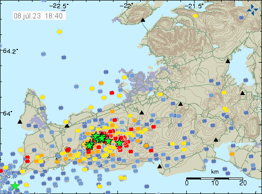
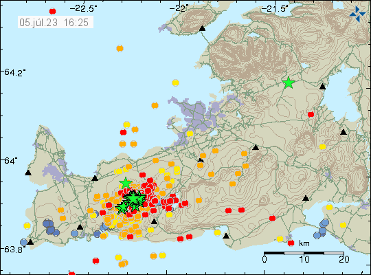
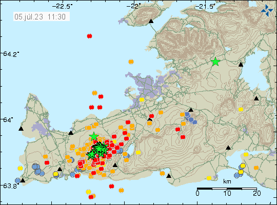
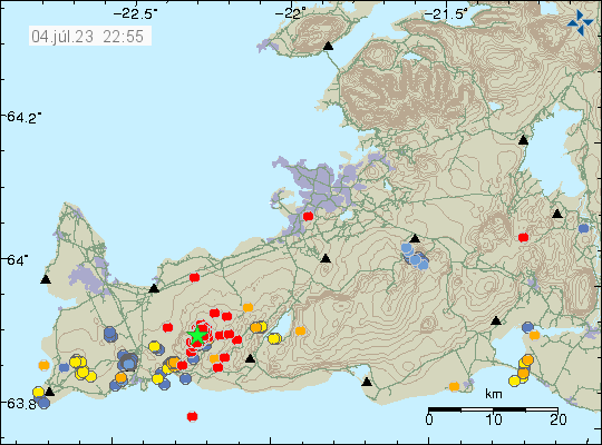
  • Three earthquakes with magnitude above Mw4,0 took place north east of Keilir mountain in the last 24 hours.
  • Earthquake activity is increasing north-east and north of Keilir mountain. Why is unclear, it is a possibility that magma is creating a path for it self that way.
  • The magma seems stuck in the crust and there doesn’t seems to have stopped the inflow of magma from the deep mantle. This is going to result in increased pressure in the dyke until an eruption happens.
  • Risk of strong earthquakes is high and might get higher until an eruption starts.


Heavy earthquake activity remains in Fagradalsfjall - Keilir area. With the new activity area north-east of Keilir mountain. Time on map is 9 July 2023 at 15:55 UTC.
Heavy earthquake activity in Fagradalsfjall – Keilir mountain. Copyright of this image belongs to Icelandic Met Office.

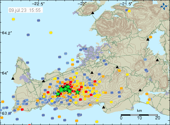
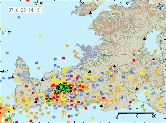
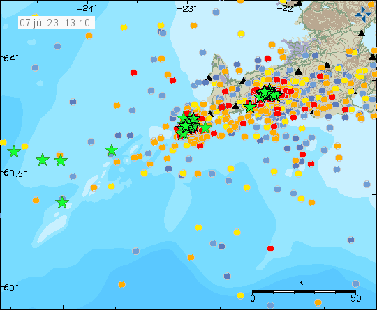
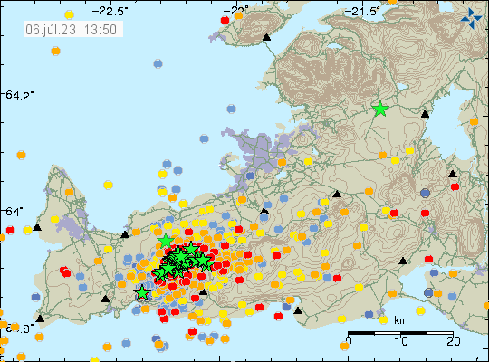
Since the start of this activity, around 12000 earthquakes have been recorded by Icelandic Met Office according to the news. Strongest earthquake at the writing of this article is at magnitude Mw4,8.

Stress related earthquake in Krýsuvík-Trölladyngja volcano system

Today (8. July 2023) at 17:57 UTC an earthquake with magnitude of Mw4,5 took place in Krýsuvík-Trölladyngja volcano system. This is a stress realted earthquake because of the inflation between Keilir and Fagradalsfjall mountain.

Difficult to see in all the activity, on the right there is a green star and a lot of red dots below it. That is where the earthquake took place. There's a lot of activity on this map because of Fagradalfjall mountain.
The earthquake activity in Krýsuvík is on the right on this map. A green star with a lot of red dots under it. Copyright of this image belongs to Icelandic Met Office.

More of this earthquakes are going to happen both east and west of the dyke between Keilir and Fagradalsfjall mountains. Both before an eruption and after it ends. This type of earthquakes can have magnitude above Mw5,0 and they can happen in areas that have been quiet so far.

Update on the activity in Fagradalsfjall mountain on 7th July 2023 at 14:28 UTC

This is going to be a really short article. Because an eruption might be about to start. Difficult to be sure, but there’s a chance. Eruption has not started at the writing of this article.

  • Largest earthquake in the last 24 hours seems to be a magnitude Mw4,3. I no longer can keep up with all this earthquake activity.
  • Inflation in area close to Keilir has reached 200mm (20cm) in less than 48 hours when this started.
  • Inflow of magma is estimated to be 88m3/s and that is a lot of magma moving and moving fast.
A lot of earthquakes in Fagradalsfjall mountain. Too many earthquakes too count and too many green starts.
Heavy earthquake activity in Fagradalsfjall mountain. Copyright of this image belongs to Icelandic Met Office.

It is unclear where the eruption is going to happen. But there has been a drop in earthquake activity that strongly suggest that magma is close to finding a path to the surface. According to measurements, the magma is now less than 1 km away from the surface.

Update on earthquake activity close to Eldey island on Reykjanes ridge on 7th July 2023 at 13:31 UTC

This is a short update because there’s a lot going on.

  • Largest earthquake during the last 24 hours close to Eldey island had a magnitude of Mw4,5.
  • This earthquake swarm looks like a dyke intrusion. Since the area is out in the ocean it is impossible to be sure.
  • Difficult to know if an eruption is going to happen in this area. If an eruption happens, effects are unlikely to be big because of ocean depth.
A lot of green stars all over the place and a lot of red dots. Since there has been heavy earthquake activity on Reykjanes ridge and Reykjanes peninsula in last few days.
Strong earthquake swarm activity on Reykjanes ridge and Reykjanes peninsula. Copyright of this image belongs to Icelandic Met Office.

It is my opinion that is unlikely to be an earthquake activity that is connected to the inflation in Fagradalsfjall mountain. Those earthquakes are closer to Fagradalsfjall mountain. It can’t be ruled out, but is unlikely to be the reason for this activity. Earlier activity in this same area also makes this unlikely to be a tectonic earthquake activity. It can’t be ruled out. Areas out in the ocean are always more difficult to figure out than activity on land with easier access.

Update on activity in Fagradalsfjall mountain on 6th July 2023 at 14:20 UTC

This is a short update because there’s a lot going on.

  • Earthquake activity started to drop around 04:00 this night according to Icelandic Met Office and seems to continue to drop at the writing oft his article. This suggests that an eruption might be getting close in time.
  • Strong earthquakes might still happen even if earthquake activity is dropping.
  • Movement on GPS is close to 50mm in some locations. That’s a lot more than in earlier eruptions. When it was at most from 15mm to 25mm in some locations. Movement is not equal in all directions and location on GPS.
  • During the day the earthquakes started to move south again towards Fagradalsfjall mountain. At the same time, number of earthquakes dropped.
  • Here are the web cameras I know of as writing of this article. Rúv, Reykjanes North, Reykjanes south, Live from Iceland, Fagradalsfjall, Live from Iceland, Langihryggur, Morgunblaðið, Perlan.
  • It is impossible to know when an eruption starts.


A lot of green stars and red dots in Fagradalsfjall mountain and on Reykjanes peninsula because of misplaced earthquakes.
Strong earthquake activity in Fagradalsfjall mountain. Copyright of this image belongs to Icelandic Met Office.

How long the wait until an eruption happens is impossible to know. Because of activity in this area in the last two years, the crust around Fagradalsfjall mountain and nearby areas is weak and can allow magma to pass more easily then it otherwise would. It remains a question if there’s some type of block that the magma can’t get trough close to Keilir mountain. Magma is always going to find path of least resistance and erupt at that location. That location is now somewhere between Keilir and Fagradalfjall mountains.

Increased conductivity in Múlakvísl glacier river from Mýrdalsjökull glacier

Currently there’s a unusual high conductivity in Múlakvísl glacier river. There’s almost no earthquake activity in Katla volcano at the writing of this article. What is expected is that a new glacier flood might happen in next few days in Múlakvísl glacier river and other nearby glacier river possibly.

Few dots and a green star just west of Mýrdalsjökull glacier that is a ghost earthquake from Fagradalsfjall mountain activity in Katla volcano.
All quiet in Katla volcano. The green star is a ghost earthquake. Copyright of this image belongs to Icelandic Met Office.

Currently there are no clear signs that Katla volcano is about to start erupting.

Earthquake swarm close to Eldey and Eldeyjarboða á Reykjanes ridge

It seems that sometimes in the last 24 hours an earthquake swarm started close to Eldey and Eldeyjarboða on the Reykjanes ridge. Largest earthquakes seems to be around Mw3,2 to Mw3,7 or in around that magnitude. Since it is close to impossible to see the earthquakes on the map in all the activity that is happening close to Keilir mountain and Fagradalsfjall mountain.

Green stars out in the ocean is the activity on the Reykjanes ridge. There's a lot of activity on this map and the whole thing is a mess to read.
Heavy earthquake activity on the Reykjanes peninsula and Reykjanes ridge. Copyright of this image belongs to Icelandic Met Office.

I don’t know if this earthquake swarm is connected to what is happening in Fagradalsfjall mountain and Keilir mountain. It seems unlikely, but this activity might have been triggered by that earthquake swarm. What is going on there is unclear. Since this is out in the ocean.

Update on Fagradalsfjall mountain activity at 16:35 UTC on 5th July 2023

This is a short update since there is a lot going on.

  • Largest earthquake recorded at the writing of this article is Mw4,8 from earlier this morning.
  • Larger earthquakes are growing in numbers. There is now also a warning for possible Mw6,3 earthquake on Reykjanes peninsula following this earthquake swarm and dyke intrusion into Fagradalsfjall mountain.
  • The dyke intrusion is coming up just south of Keilir mountain.
  • Based on what I am seeing, it is possible that current dyke intrusion into Fagradalsfjall mountain is larger than the first eruption in March 2021. If this is accurate is a wait and see situation until an eruption starts.
  • It is possible to view the earthquake activity in real time here, at Raspberry Shake website.


A lot of green stars and red dots in Fagradalsfjall mountain on Reykjanes peninsula. Time on map is 5. July 2023 at 16:25 UTC.
Heavy earthquake activity in Fagradalsfjall mountain. Copyright of this image belongs to Icelandic Met Office.

All data now suggest that an eruption is going to happen. Where it is going to start erupting is impossible to know and it is not possible to know when it is going to start erupting.

I’ll try to post update when more is known about what is going on.

Update on Fagradalsfjall activity at 11:40 on 5. July 2023

This is a short update since this situation is changing quickly.

  • Largest earthquake recorded so far had a magnitude of Mw4,8 and was felt over a wide area.
  • Uncertainty level has been declared for Fagradalsfjall mountain area because of this earthquake activity and the risk of an eruption.
  • Current depth of the magma is now 3 to 6 km and is getting shallower by each hour.
  • Over 2000 earthquakes have been recorded at the writing of this article.


A lot of earthquakes in Fagradalsfjall mountain. Time on image is 11:30 on 5th july 2023.
Earthquake swarm activity in Fagradalsfjall mountain. Copyright of this image belongs to Icelandic Met Office.

The only web camera that I know of at the moment and is showing Fagradalsfjall mountain is this one here. When the eruption starts, it should be visible in some part on this web camera. I hope that other closer web cameras are going online soon. Those where run by Rúv and mbl.is in last eruption.

Update on the activity in Fagradalsfjall mountain

This is a short update on the activity in Fagradalsfjall mountain.

Currently there have been around 200 earthquakes that have happened at the writing of this article. The first magnitude Mw3,1 took place at 22:45 UTC. This magnitude is automatic and is going to change when the earthquake is reviewed.

Green star and a lot of red dots in Fagradalsfjall mountain.
The heavy earthquake activity in Fagradalsfjall mountain. Copyright of this image belongs to Icelandic Met Office.

There’s a lot going on at the writing of this article and the situation can change without warning. I’ll post updates as best I can.