Strong earthquake 1,4 km east of Keilir mountain

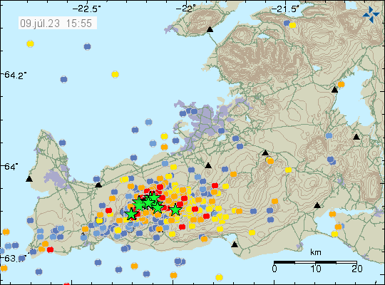
Today (9. July 2023) at 22:22 UTC an earthquake with magnitude of Mw5,2 happened 1,4 km east of Keilir mountain. This earthquake did shake Keilir mountain and resulting a small dust cloud. This earthquake is connected to inflation that is happening just south of Keilir mountain, rather than being connected directly to magma movements in this area.

A lot of green stars close to Keilir and Fagradalsfjall on Reykjanes peninsula map. Time on map is 9th July 2023 at 23:15 UTC.
Strong earthquake activity in Fagradalsfjall mountain and Keilir mountain. Copyright of this image belongs to Icelandic Met Office.

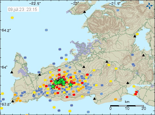
There’s a risk of more strong earthquakes like this in this area until an eruption starts.

Update on activity in Fagradalsfjall – Keilir mountains on 9th July 2023 at 16:11 UTC

This is a short update, because there’s little to report.

  • Three earthquakes with magnitude above Mw4,0 took place north east of Keilir mountain in the last 24 hours.
  • Earthquake activity is increasing north-east and north of Keilir mountain. Why is unclear, it is a possibility that magma is creating a path for it self that way.
  • The magma seems stuck in the crust and there doesn’t seems to have stopped the inflow of magma from the deep mantle. This is going to result in increased pressure in the dyke until an eruption happens.
  • Risk of strong earthquakes is high and might get higher until an eruption starts.


Heavy earthquake activity remains in Fagradalsfjall - Keilir area. With the new activity area north-east of Keilir mountain. Time on map is 9 July 2023 at 15:55 UTC.
Heavy earthquake activity in Fagradalsfjall – Keilir mountain. Copyright of this image belongs to Icelandic Met Office.

Since the start of this activity, around 12000 earthquakes have been recorded by Icelandic Met Office according to the news. Strongest earthquake at the writing of this article is at magnitude Mw4,8.