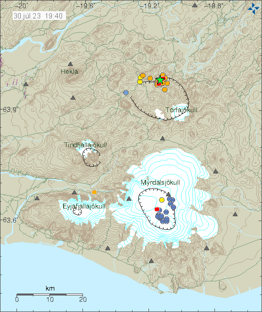
Today (30. July 2023) an earthquake swarm took place in Torfajökull volcano. This volcano is located north of Katla volcano (Mýrdalsjökull glacier). This area has had regular earthquake swarms over the year. Why is not clear. There is no clear signal of magma movement in this area. Torfajökull erupts highly Felsic magma that’s mostly explosive and some type of magma that can flow as a lava flow (maybe in later stage of an eruption, I don’t know for sure).
Earthquake activity in Torfajökull volcano. Copyright of this image belongs to Icelandic Met Office.
The largest earthquake in this swarm had a magnitude of Mw3,2. It was felt in nearby tourist areas and caused few rock slides. Icelandic Met Office is still warning against rock slides because of this earthquakes close to the earthquake swarm location. There is a ongoing risk of more stronger earthquakes in this area of the volcano at the writing of this article.
Rúv News and Earth Science at University of Iceland is reporting that the eruption in Fagradalsfjall at Litli-Hrútur might end in one or two weeks time. This is based on how much the lava flow from the crater is currently decreasing. This would also be mostly in line with the eruption in Meradalir valley in 2021, that lasted for two weeks. This eruption has been slightly longer than that eruption, since it has been slightly larger in volume of magma erupting.
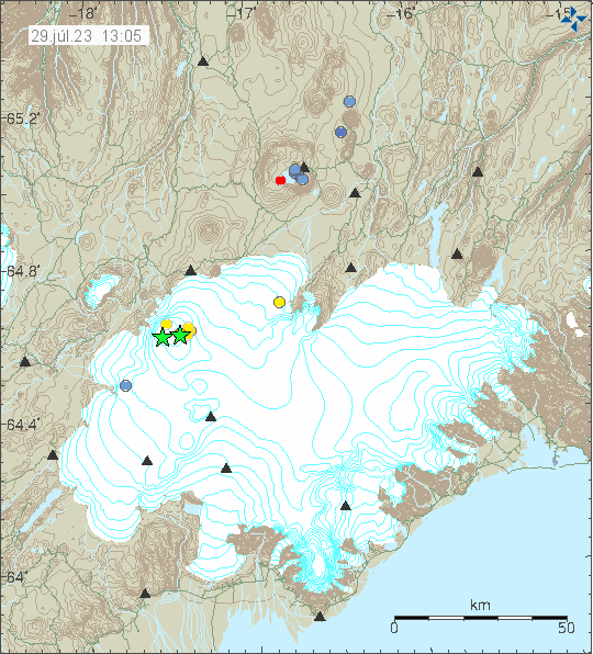
Yesterday (28. July 2023) at 23:42 UTC and 23:55 UTC two earthquakes with magnitude of Mw3,2 and Mw3,6 took place in Bárðarbunga volcano. EMSC is reporting the earthquake at 23:55 as Mw4,7 and that information can be found here.
Earthquake activity in Bárðarbunga volcano. Copyright of this image belongs to Icelandic Met Office.
There where few smaller earthquakes following this larger earthquakes. This is normal inflation activity in Bárðarbunga volcano and this is going to continue for next 30 to 70 years (based on earlier history).
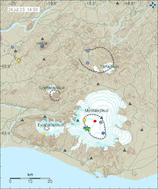
Yesterday (23. July 2023) at 23:17 UTC an earthquake with magnitude of Mw3,5 took place in Katla volcano. This earthquake was felt to Hvolsvellir town in south Iceland.
Earthquake in Katla volcano. Copyright of this image belongs to Icelandic Met Office.
No other earthquake or activity took place following this earthquake. Katla volcano remains quiet at the writing of this article.
This is a short update. Since there is not a lot of information about this.
The crater might collapse at any time without warning. Geologists that monitor the eruption have noticed that the crater has started to get larger and is now full of lava. This means it is going to collapse. What direction is not known. It is my view that it is going to collapse to the east because of least resistance in that direction.
When the crater collapses the lava is going to flow more than 100m/s in whatever direction it flows.
Tourists are in high danger close the crater because of this collapse risk.
Dyke intrusion has been detected east of Keilir mountain. Along with increased ground temperature, that means the magma is at shallow depth in the crust. This area might erupt soon in similar way as is now happening close to Litli-Hrútur.
This is all the information I have now and only thing that has changed in the eruption in the last 13 days.
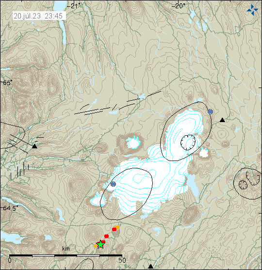
Since 14. July 2023 there has been a minor earthquake swarm close to Skjaldbreið lava shield just south of Presthnjúkur volcano. Largest earthquake took place yesterday (20. July 2023), with a magnitude of Mw3,0.
Earthquake activity close to Skjaldbreið lava shield. Copyright of this image belongs to Icelandic Met Office.
This is tectonic earthquake swarm and its just normal activity. Its not connected to eruption in Fagradalsfjall mountain, because its outside of that area influence. This earthquake swarm is ongoing at the writing of this article.
This article is short. The eruption is mostly stable at the writing of this article but the situation can change quickly without warning.
The eruption has changed in last few hours. It seems to be in only one crater that is slowly forming. The eruption has stopped at the north most end of the eruption fissure. At the writing of this article.
The dyke now extends 1 km under Keilir mountain in the direction of north-east. This might be a new dyke intrusion and not connected to the dyke that started the current eruption. This might result in a second eruption soon, but its too early to know for sure at the writing of this article.
The eruption started large fires in the moss and other plants in this area around Litli-Hrútur. This has resulted in massive toxic smoke in this area.
There’s a high risk of the volcano gas from the eruption, along with the toxic smoke from all the plants and moss burning.
Interestingly, while earthquake activity has dropped it has not stopped. Why that has happened is a bit of a mystery, it might be connected to the possible new dyke that has formed under Keilir mountain.
Yesterday (10. July 2023) the longest the fissure extent was at 1500 meters or 1,5 km. Since then it has gone down to one erupting crater that seems to be 50 meters to 100 meters long.
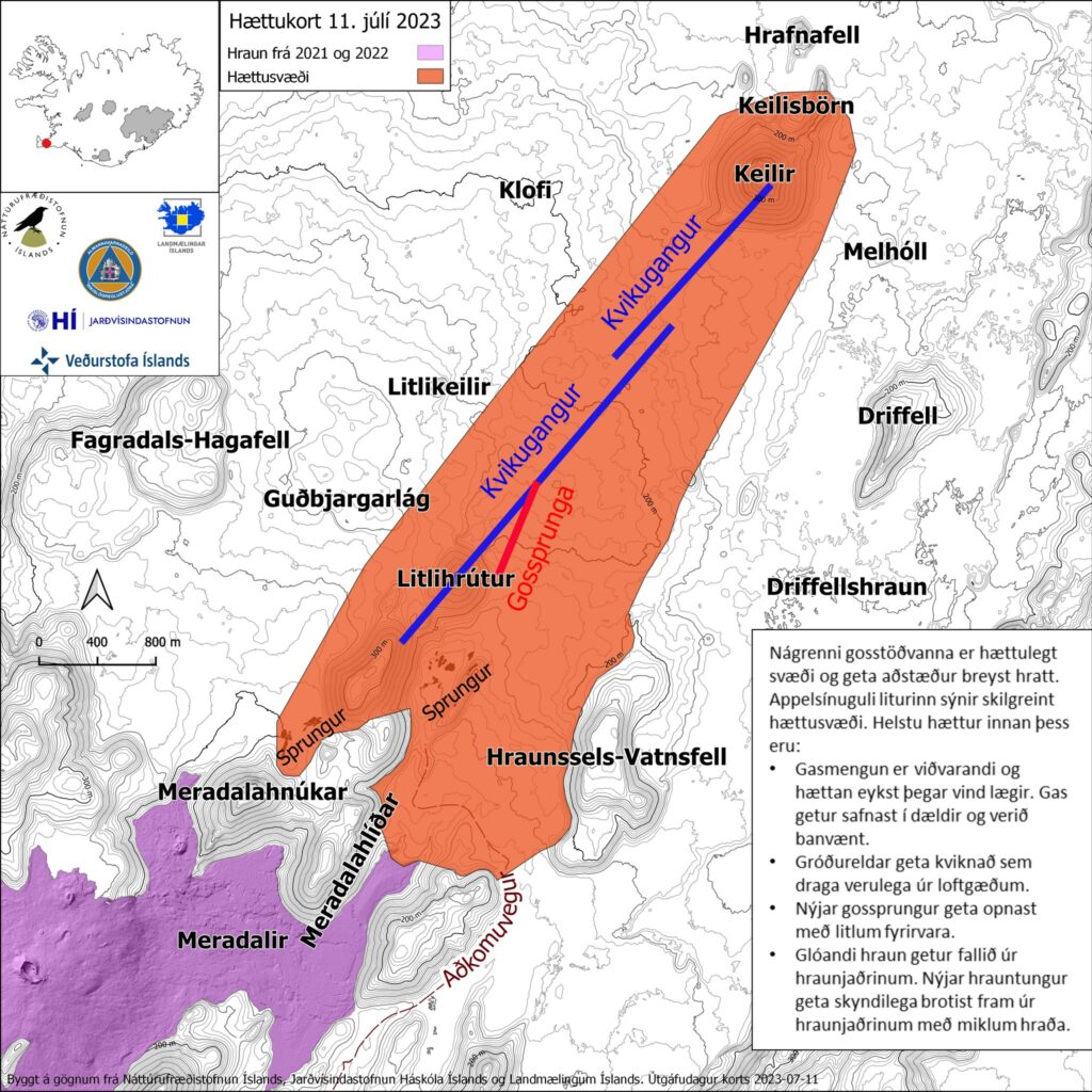
Map of the danger area around the eruption. The orange area is the danger zone that people should not travel over. Copyright of this image belongs to Icelandic Met Office and others.
It is impossible to know how long this eruption is going to last. Since dyke intrusions are poor magma containers this eruption might be a short one if there isn’t a constant supply of fresh magma from the deep mantle. Its too early to know if that is the case here. I have also noticed that once the eruption ends in any area, that area is not going to erupt again. When the eruption ends, it ends forever and that makes this a single eruption activity or crater rows. This area might be Monogenetic volcanic field (Wikipedia).
Since this type of eruptions are mostly uneventful and just continue. I plan on only posting updates when there are some news or changes to the eruption happen.
Update at 17:41 UTC
ISOR is reporting that their station called FAF (Fagradalsfjall) has to be moved because the lava is flowing directly at it. They are going to find a new location for this station. This report can be seen here on Facebook in Icelandic.
This is a short update because events are changing quickly.
Length of the eruption fissure is uncertain, reports are conflicting. The numbers I’ve seen are from 200 meters to 900 meters long. This also might be a case of growing fissure eruption.
Harmonic tremor on the SIL station Fagradalsfjall continues to grow. Suggesting that the eruption is increasing in power since it started. This sometimes happens in lava eruptions.
The lava is flowing to the south. It might reach Meradalir valley in about one week to three weeks. Some of the lava is flowing to the north, but a lot of less of it and is only expected to flow in the nearby area. There is no risk at current time for any damage to infrastructure or property.
There’s a risk of new fissures opening up in this area without warning.
This area is remote and difficult to go towards. Police has closed roads for the time being for safety reasons.
I’ll post new update soon as I have any new information or if anything changes. Experience has shown that this type of eruptions are rather uneventful for a longer time periods. I’ll adjust my updates in accordance with that.
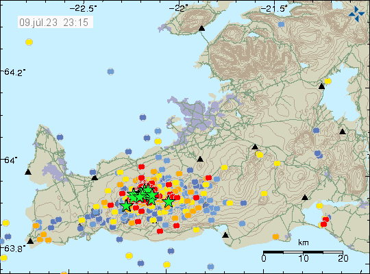
Today (9. July 2023) at 22:22 UTC an earthquake with magnitude of Mw5,2 happened 1,4 km east of Keilir mountain. This earthquake did shake Keilir mountain and resulting a small dust cloud. This earthquake is connected to inflation that is happening just south of Keilir mountain, rather than being connected directly to magma movements in this area.
Strong earthquake activity in Fagradalsfjall mountain and Keilir mountain. Copyright of this image belongs to Icelandic Met Office.
There’s a risk of more strong earthquakes like this in this area until an eruption starts.